| Type |
Château |
Commune |
Protection |
Notes |
Coordonnées |
Illustration |
|---|

 |
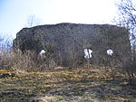
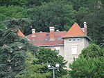
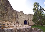
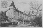
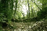
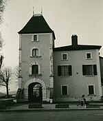
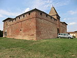
Vieux Bourg de L'Abergement-Clémenciat |
L'Abergement-Clémenciat |
 Classé MH (1994) Classé MH (1994)
Notice no PA00132969 |
XIVe siècle |
46° 09′ 33″ N, 4° 55′ 11″ E |
 |
 |
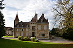
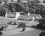
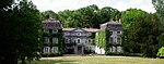
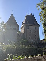
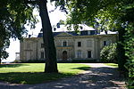
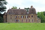
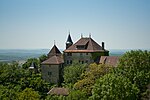
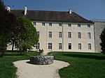
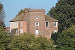
Château de L'Abergement-Clémenciat |
L'Abergement-Clémenciat |
|
vers 1700 et XIXe siècle |
46° 09′ 31″ N, 4° 55′ 08″ E |
 |
|
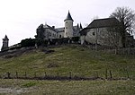
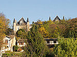
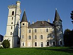
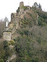
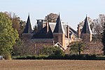
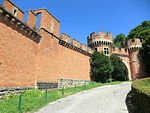
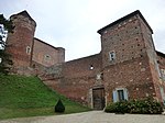
Château des Allymes |
Ambérieu-en-Bugey |
Classé MH (1960, 1993)
Inscrit MH (1967)
Notice no PA00116288 |
XIVe et XVIe siècles |
45° 58′ 25″ N, 5° 24′ 37″ E |
 |
|
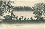
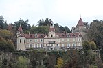
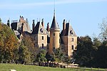
Château d'Ambérieux-en-Dombes |
Ambérieux-en-Dombes |
Classé MH (1905)
Inscrit MH (2019)
Notice no PA00116290 |
XVe siècle,
trois tours ont été conservées |
45° 59′ 50″ N, 4° 54′ 11″ E |
 |
 |
Château d'Ambronay
(Château de Blains) |
Ambronay
(Mairie d'Ambronay) |
|
XVIe siècle |
46° 00′ 28″ N, 5° 21′ 40″ E |
 |
|
Château d'Andert |
Andert-et-Condon |
Inscrit MH (1990)
Notice no PA00116603
Notice no IA01000326 |
XVe et XVIIIe siècles,
château perché |
45° 46′ 55″ N, 5° 39′ 47″ E |
 |
 |
Château d'Anglefort |
Anglefort |
Inscrit MH (1974)
Notice no PA00116292 |
Moyen Age,
reconstruit en 1741 |
45° 54′ 48″ N, 5° 48′ 46″ E |
 |
 |
Château de l'Aumusse
(de Laumusse) |
Crottet
(Chemin de l'Aumusse) |
|
Moyen Âge,
était une importante commanderie templière |
46° 17′ 22″ N, 4° 54′ 07″ E |
 |
 |
Château des Avaneins |
Mogneneins |
|
XIXe siècle,
hébergement |
46° 08′ 37″ N, 4° 49′ 09″ E |
 |
 |
Fort-les-Bancs |
Virignin |
|
1840-1849 |
45° 42′ 52″ N, 5° 43′ 25″ E |
 |
|
Château de la Barre |
Brégnier-Cordon |
|
XIVe siècle |
45° 37′ 56″ N, 5° 37′ 22″ E |
 |
|
Château de la Bâtie |
Montceaux |
Inscrit MH (2006)
Notice no PA00116429 |
XIIIe et XVIe siècles,
XIXe siècle |
46° 05′ 44″ N, 4° 49′ 29″ E |
 |
 |
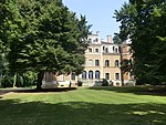
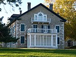
Château de Beau-Logis |
Mionnay |
|
XXe siècle |
45° 53′ 45″ N, 4° 58′ 00″ E |
 |
 |
Château de Beaujeu |
Romans
(Impasse du Château de Beaujeu) |
|
XXe siècle,
maison bourgeoise |
46° 07′ 15″ N, 5° 00′ 28″ E |
 |
|
Château de Beaumont |
Saint-Étienne-sur-Chalaronne
(Route de Thoissey) |
Inscrit MH (2006)
Notice no PA01000020 |
XIXe siècle |
46° 09′ 28″ N, 4° 51′ 32″ E |
 |
|
Château de Beauregard |
Beauregard |
|
XIIIe et XIXe siècles |
46° 00′ 02″ N, 4° 45′ 15″ E |
 |
|
Château de Beauretour |
Saint-Germain-les-Paroisses |
Inscrit MH (2003)
Notice no PA01000010 |
vers 1400 |
45° 46′ 53″ N, 5° 37′ 25″ E |
 |
|
Château de Bellevue |
Saint-Didier-sur-Chalaronne
(Chemin de Bellevue) |
|
parc à l'anglaise |
46° 11′ 25″ N, 4° 49′ 51″ E |
|
|
Château de Béost |
Vonnas |
Inscrit MH (2016)
Notice no PA01000044 |
XVIIIe et XIXe siècles |
46° 11′ 45″ N, 4° 59′ 41″ E |
 |
|
Château médiéval de Bey |
Bey
(Allée de l'Église) |
|
|
46° 12′ 46″ N, 4° 51′ 00″ E |
 |
|
Château Bouchet |
Fareins |
|
XIXe siècle,
parc avec 180 essences d'arbres |
46° 01′ 13″ N, 4° 45′ 49″ E |
 |
 |
Château de Bouligneux |
Bouligneux |
Inscrit MH (1926)
Notice no PA00116316 |
début du XIVe siècle,
maison forte |
46° 01′ 27″ N, 4° 59′ 29″ E |
 |
|
Château de Bourdonnel |
Saint-André-d'Huiriat
(Chemin du Bourdonnel) |
|
|
46° 12′ 27″ N, 4° 55′ 33″ E |
 |
|
Château de Brénon |
Saint-Just
(Rue de la Torchère) |
|
|
46° 11′ 05″ N, 5° 16′ 57″ E |
|
|
Château du Breuil-de-Monthieux |
Monthieux |
|
|
|
|
|
Château de La Bruyère |
Saint-Bernard
(48 quai Sainte-Catherine) |
Inscrit MH (1997)
Notice no PA01000007 |
XVIIIe siècle |
45° 57′ 06″ N, 4° 44′ 10″ E |
 |
|
Donjon de Buenc |
Hautecourt-Romanèche |
Inscrit MH (1974)
Notice no PA00116411 |
milieu du XIIe siècle |
46° 09′ 29″ N, 5° 24′ 27″ E |
 |
|
Château du Carillon |
Mogneneins
(Montée de Serrans) |
|
|
46° 08′ 56″ N, 4° 49′ 03″ E |
|
|
Château de Challes |
Saint-Didier-sur-Chalaronne
(Avenue des Écoles) |
 |
XVIIe et XIXe siècles |
46° 10′ 33″ N, 4° 47′ 57″ E |
|
|
Château de Champdor |
Champdor |
|
début du XVIIIe siècle |
46° 00′ 53″ N, 5° 35′ 51″ E |
 |
|
Château de Chanay |
Chanay |
|
XIVe siècle |
46° 00′ 16″ N, 5° 47′ 11″ E |
|
|
Château de Chânes |
Béligneux
(Route du Dauphiné) |
|
|
45° 50′ 55″ N, 5° 09′ 38″ E |
 |
|
Château de Châtenay |
Chanoz-Châtenay |
Inscrit MH (1987)
Notice no PA00116362 |
XIe siècle,
maison forte |
46° 11′ 10″ N, 5° 01′ 09″ E |
 |
|
Château du Chapuis |
Romans
(Route du Chapuis) |
|
|
46° 07′ 27″ N, 4° 59′ 22″ E |
|
|
Château de la Chassagne |
Neuville-les-Dames |
|
|
46° 08′ 37″ N, 4° 59′ 20″ E |
|
|
Château de Châtillon-sur-Chalaronne |
Châtillon-sur-Chalaronne |
Inscrit MH (1927)
Notice no PA00116366 |
XVe siècle |
46° 07′ 18″ N, 4° 57′ 21″ E |
 |
|
Château de Chavagneux |
Genouilleux
(Chavagneux) |
Inscrit MH (1942)
Notice no PA00116405 |
XIIIe siècle |
46° 07′ 36″ N, 4° 47′ 51″ E |
 |
|
Château de Chazey-sur-Ain |
Chazey-sur-Ain |
Inscrit MH (1987)
Notice no PA00116377 |
XIIe siècle |
45° 53′ 44″ N, 5° 15′ 12″ E |
 |
|
Château de Chenavel |
Jujurieux |
|
XIVe siècle |
46° 03′ 54″ N, 5° 23′ 12″ E |
 |
|
Château de Chevigney |
Neuville-les-Dames
(Place du Chapitre) |
Inscrit MH (1980)
Notice no PA00116441 |
XVIIIe siècle,
maison |
46° 09′ 47″ N, 5° 00′ 11″ E |
 |
|
Château Chiloup |
Dagneux
(Dagneux) |
|
XIVe siècle,
maison forte |
45° 50′ 59″ N, 5° 04′ 29″ E |
 |
|
Château de Chiloup |
Saint-Martin-du-Mont
(Saint-Martin-du-Mont) |
|
XIVe et XIXe siècles |
46° 05′ 02″ N, 5° 17′ 56″ E |
 |
|
Château de Cillery |
Jassans-Riottier |
|
XIXe siècle |
45° 59′ 43″ N, 4° 45′ 19″ E |
|
 |
Château de Clerdan |
Romans
(Allée de Clerdan) |
|
milieu du XIXe siècle |
46° 06′ 22″ N, 4° 59′ 11″ E |
|
|
Château de Coiselet |
Matafelon-Granges
(Coiselet) |
Inscrit MH (1983)
Notice no PA00116423 |
XIVe siècle,
maison forte |
46° 17′ 23″ N, 5° 35′ 15″ E |
 |
|
Château de Corcelles |
Trévoux |
Inscrit MH (1996)
Notice no PA01000004 |
vers 1840 |
45° 56′ 51″ N, 4° 45′ 42″ E |
 |
|
Château de Cordon |
Brégnier-Cordon |
|
XIIe siècle |
45° 37′ 25″ N, 5° 37′ 33″ E |
 |
|
Château de Cornillon |
Saint-Rambert-en-Bugey |
|
XIIe siècle |
45° 56′ 59″ N, 5° 26′ 17″ E |
 |
|
Château de Crassy |
Divonne-les-Bains |
|
XIXe siècle |
46° 21′ 23″ N, 6° 08′ 02″ E |
 |
|
Château de Cuchet |
Saint-Sorlin-en-Bugey |
|
XIIIe siècle? |
45° 52′ 59″ N, 5° 22′ 35″ E |
 |
|
Château de la Cueille |
Poncin
(La Cueille) |
|
XIIIe siècle |
46° 06′ 30″ N, 5° 25′ 22″ E |
 |
|
Château du Déaux |
Mogneneins
(Chemin du Deaulx) |
|
XIVe et XVIIe siècles |
46° 09′ 31″ N, 4° 48′ 52″ E |
|
|
Château de Divonne |
Divonne-les-Bains |
|
XVIIIe et XIXe siècles,
endommagé par un incendie 2017 |
46° 21′ 23″ N, 6° 08′ 02″ E |
 |
|
Château de Dorches |
Chanay
(La Dorches) |
Inscrit MH (1927)
Notice no PA00116361 |
XIIe siècle |
45° 59′ 48″ N, 5° 47′ 42″ E |
 |
|
Château de Dortan |
Dortan |
Inscrit MH (1997)
Notice no PA01000005 |
XVe et XVIIIe siècles |
46° 19′ 03″ N, 5° 39′ 36″ E |
 |
|
Château de Douglas |
Montréal-la-Cluse
(Avenue François Pierre de Douglas) |
|
|
46° 11′ 10″ N, 5° 34′ 21″ E |
 |
|
Château des Éclaz |
Cheignieu-la-Balme
(Les Eclaz) |
Inscrit MH (1988)
Notice no PA00116378 |
XIIIe et XVIIe siècles,
maison forte |
45° 49′ 30″ N, 5° 36′ 14″ E |
 |
|
Château d'Épeyssoles |
Vonnas
(Route de Mézériat) |
|
|
46° 14′ 03″ N, 5° 00′ 16″ E |
 |
|
Château de la Falconnière |
Saint-André-d'Huiriat
(Chemin de la Falconnière) |
|
|
46° 12′ 48″ N, 4° 55′ 14″ E |
 |
|
Château de Ferney-Voltaire |
Ferney-Voltaire |
Classé MH (1958)
Notice no PA00116395 |
XVIIIe siècle |
46° 15′ 21″ N, 6° 06′ 29″ E |
 |
|
Château de Fetan |
Trévoux
(Route de Saint-Bernard) |
Inscrit MH (1973)
Notice no PA00116583 |
XVIIe siècle |
45° 56′ 35″ N, 4° 44′ 59″ E |
 |
|
Château de Fléchères |
Fareins |
Classé MH (1985)
Inscrit MH (2001)
Notice no PA00116393 |
XVIIe et XIXe siècles |
46° 01′ 51″ N, 4° 45′ 30″ E |
 |
|
Château de Fleyriat |
Viriat |
Inscrit MH (2013)[1]
Notice no PA01000038 |
XVIIIe et XIXe siècles |
46° 13′ 40″ N, 5° 12′ 36″ E |
 |
|
Château de Florimont |
Gex |
|
XIVe siècle |
|
|
|
Château de la Garde |
Bourg-en-Bresse
(La Garde) |
|
|
46° 11′ 01″ N, 5° 15′ 29″ E |
|
|
Château de Genoud |
Certines
(Genoud) |
Inscrit MH (2006)
Notice no PA01000018 |
XIVe et XVIIe siècles |
46° 07′ 33″ N, 5° 16′ 03″ E |
 |
|
Château de Gourdans |
Saint-Jean-de-Niost |
|
XVIIIe siècle |
45° 49′ 45″ N, 5° 13′ 38″ E |
|
|
Château du Grand-Casset |
La Boisse
(Chemin du Grand-Casset) |
|
détruit en 2017 |
45° 50′ 53″ N, 5° 02′ 12″ E |
 |
|
Château des Greffets |
Viriat
(Chemin de l'Aigrefeuille) |
|
|
46° 15′ 10″ N, 5° 11′ 13″ E |
|
|
Château de la Griffonnière |
Bâgé-Dommartin
(Impasse de la Griffonnière, Bâgé-la-Ville) |
|
XVIIe et XIXe siècles |
46° 18′ 32″ N, 4° 56′ 29″ E |
 |
|
Château de Grillerin |
Revonnas
(Route de Tossiat) |
|
|
46° 09′ 33″ N, 5° 19′ 42″ E |
 |
|
Château de Grilly |
Grilly |
|
XIIIe siècle |
46° 19′ 41″ N, 6° 06′ 53″ E |
 |
|
Château de Groslée |
Groslée-Saint-Benoît
(Groslée) |
Inscrit MH (1992)
Notice no PA00116617 |
site archéologique |
45° 42′ 50″ N, 5° 33′ 39″ E |
 |
|
Château d'Honoré d'Urfé |
Virieu-le-Grand |
Inscrit MH (1935)
Notice no PA00116597 |
XVe siècle |
45° 50′ 51″ N, 5° 38′ 45″ E |
 |
|
Château d'Hostel |
Belmont-Luthézieu
(Belmont) |
|
|
45° 53′ 14″ N, 5° 39′ 50″ E |
|
|
Château de Jasseron |
Jasseron |
Inscrit MH (1927)
Notice no PA00116414 |
XIIIe siècle |
46° 13′ 00″ N, 5° 20′ 03″ E |
 |
|
Château de Joyeux |
Joyeux |
Classé MH (2009)
Notice no PA01000022 |
fin du XIXe siècle |
45° 57′ 58″ N, 5° 05′ 56″ E |
 |
|
Château de Juis |
Savigneux
(Juis) |
Inscrit MH (1984)
Notice no PA00116577 |
Xe et XIVe siècles |
45° 59′ 06″ N, 4° 51′ 03″ E |
 |
|
Château de Léaz |
Léaz |
|
|
46° 05′ 55″ N, 5° 53′ 20″ E |
 |
|
Château de Longecombe |
Hauteville-Lompnes |
|
XIIIe siècle |
45° 56′ 59″ N, 5° 33′ 02″ E |
|
|
Château de Longes |
Sulignat
(Longes) |
Inscrit MH (1991)
Notice no PA00116612 |
XVIIe et XIXe siècles |
46° 11′ 06″ N, 4° 58′ 34″ E |
 |
|
Château de Loriol |
Confrançon
(Loriol) |
Inscrit MH (1994)
Notice no PA00132808 |
XIXe siècle |
46° 16′ 44″ N, 5° 02′ 24″ E |
 |
|
Château de Loyes |
Villieu-Loyes-Mollon |
Inscrit MH (2008)
Notice no PA01000030 |
XIXe siècle |
45° 55′ 36″ N, 5° 13′ 50″ E |
 |
|
Château de Luisandre |
Saint-Rambert-en-Bugey |
|
XIVe siècle |
45° 58′ 41″ N, 5° 25′ 07″ E |
 |
|
Château de Luponnas |
Vonnas
(Route de Luponnas) |
|
|
46° 13′ 53″ N, 4° 58′ 35″ E |
 |
|
Château de Mâchuraz |
Vieu
(Clos de Machuraz) |
Inscrit MH (2006)
Notice no PA01000021 |
XIXe siècle |
45° 53′ 56″ N, 5° 40′ 57″ E |
 |
|
Château de la Madeleine |
Bourg-en-Bresse
(Avenue Pierre Semard) |
 Patrimoine XXe siècle[2] Patrimoine XXe siècle[2] |
|
46° 12′ 06″ N, 5° 12′ 58″ E |
 |
|
Château Marcel |
Saint-Jean-de-Niost
(Route de Port-Galland) |
|
XVIe siècle
maison forte |
45° 49′ 41″ N, 5° 13′ 08″ E |
|
|
Château de Mareste |
Chavannes-sur-Reyssouze |
Inscrit MH (1969)
Notice no PA00116371 |
XVIIe siècle |
46° 25′ 49″ N, 5° 00′ 45″ E |
 |
|
Château de Marnix |
Parves et Nattages
(Nattages) |
|
|
45° 42′ 59″ N, 5° 45′ 27″ E |
 |
|
Château de Meillonnas |
Meillonnas |
Inscrit MH (2007)
Notice no PA01000023 |
XVIe et XVIIIe siècles |
46° 14′ 38″ N, 5° 21′ 05″ E |
 |
|
Château de Meximieux |
Meximieux |
|
XIIe et XIXe siècles |
45° 54′ 26″ N, 5° 11′ 27″ E |
 |
|
Château de Miribel |
Miribel |
|
XIe siècle |
45° 49′ 45″ N, 4° 56′ 56″ E |
 |
|
Château de Montagnieu |
Montagnieu |
|
|
45° 47′ 28″ N, 5° 28′ 15″ E |
 |
|
Château de Montbriand |
Messimy-sur-Saône |
Inscrit MH (1989)
Notice no PA00116424 |
XVIIIe siècle |
46° 02′ 36″ N, 4° 45′ 52″ E |
 |
|
Château du Montellier |
Le Montellier |
Classé MH (2003)
Notice no PA00116430 |
XIIIe et XVe siècles |
45° 56′ 34″ N, 5° 04′ 28″ E |
 |
|
Château de Montépin |
Bâgé-Dommartin
(Allée de Montépin, Bâgé-la-Ville) |
|
XVe siècle |
46° 17′ 45″ N, 4° 56′ 25″ E |
 |
|
Château de Montferrand |
Lagnieu |
Inscrit MH (1990)
Notice no PA00116607 |
XVe siècley
maison forte |
45° 54′ 14″ N, 5° 20′ 46″ E |
 |
|
Château de Montgriffon |
Nivollet-Montgriffon |
|
|
|
 |
|
Maison forte de Montherot |
Balan |
|
XIVe et XVIIe siècles
accueille un établissement scolaire |
45° 50′ 02″ N, 5° 05′ 40″ E |
 |
|
Château de Montluel |
Montluel |
|
XIe et XIIe siècles |
45° 51′ 12″ N, 5° 03′ 07″ E |
 |
|
Château de Montplaisant |
Montagnat
(Montplaisant) |
Inscrit MH (1981)
Notice no PA00116428 |
XVIIIe et XIXe siècles |
46° 10′ 21″ N, 5° 17′ 38″ E |
 |
|
Château de Montréal |
Montréal-la-Cluse |
|
XIIIe siècle |
46° 11′ 10″ N, 5° 34′ 02″ E |
 |
|
Château de Montribloud |
Saint-André-de-Corcy
(Montribloud) |
|
XIVe et XVIIIe siècles
néo-classique |
45° 55′ 01″ N, 4° 54′ 52″ E |
 |
|
Château de Montvéran |
Culoz |
Inscrit MH (1946)
Notice no PA00116390 |
XIVe siècle |
45° 51′ 00″ N, 5° 46′ 38″ E |
 |
|
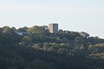
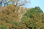
Tour de Montvert |
Lagnieu |
|
|
45° 55′ 03″ N, 5° 21′ 09″ E |
 |
|
Château de Murs |
Murs-et-Gélignieux |
|
|
45° 38′ 29″ N, 5° 39′ 58″ E |
 |
|
Château de Musinens |
Bellegarde-sur-Valserine
(Rue de Musinens) |
|
XIVe siècle
poste fortifié |
46° 06′ 55″ N, 5° 49′ 13″ E |
 |
|
Château de Noirefontaine |
Montagnat
(Noirefontaire) |
|
|
46° 10′ 01″ N, 5° 16′ 04″ E |
|
|
Château de Pennesuyt |
Bourg-en-Bresse
(Route de Ceyzeriat) |
Inscrit MH (1987)
Notice no PA00116319 |
XVIIe siècle |
46° 12′ 08″ N, 5° 15′ 16″ E |
 |
|
Château de Peyrieu |
Peyrieu
(Route du Château) |
|
|
45° 40′ 53″ N, 5° 40′ 22″ E |
 |
|
Chartreuse de Pierre-Châtel |
Virignin |
Classé MH (1999)
Notice no PA00116600 |
XIVe et XVIIe siècles |
45° 42′ 38″ N, 5° 43′ 24″ E |
 |
|
Château de Pionneins |
Illiat
(Tang) |
|
|
46° 11′ 10″ N, 4° 52′ 21″ E |
|
|
Château du Plantay |
Le Plantay |
Inscrit MH (1991)
Notice no PA00116611 |
XIVe siècle,
édifice fortifié |
46° 01′ 18″ N, 5° 04′ 53″ E |
 |
|
Château de Polletins |
Mionnay
(Chemin de la Forêt) |
|
|
45° 53′ 48″ N, 4° 55′ 02″ E |
 |
|
Château de Pommier |
Saint-Martin-du-Mont
(Saint-Martin-du-Mont) |
|
XIIIe et XVIIIe siècles |
46° 06′ 27″ N, 5° 19′ 47″ E |
 |
|
Château de Poncin |
Poncin |
Inscrit MH (1970)
Notice no PA00116531 |
XIIIe et XVIIIe siècles |
46° 05′ 13″ N, 5° 24′ 38″ E |
 |
|
Château de Pont-d'Ain |
Pont-d'Ain |
Inscrit MH (2004)
Notice no PA00116532 |
XVe et XIXe siècles |
46° 03′ 09″ N, 5° 20′ 41″ E |
 |
|
Château de Pont-de-Veyle |
Pont-de-Veyle |
Inscrit MH (1972, 2020)
Notice no PA00116533 |
XVIe siècle |
46° 15′ 57″ N, 4° 53′ 05″ E |
 |
|
Château de Prévessin-Moëns |
Prévessin-Moëns
(Route de Saint-Genis) |
|
|
46° 15′ 16″ N, 6° 04′ 28″ E |
 |
|
Château de Pyrimont |
Chanay
(Route de Pyrimont) |
|
|
46° 00′ 43″ N, 5° 48′ 17″ E |
|
|
Château des Quinsonnas |
Chanay
(Route de Quinsonnas) |
|
XIXe siècle |
46° 00′ 21″ N, 5° 47′ 10″ E |
 |
|
Château de Richemont |
Villette-sur-Ain |
Inscrit MH (1927)
Notice no PA00116596 |
XIIIe siècle |
46° 00′ 34″ N, 5° 16′ 18″ E |
 |
|
Manoir de la Rigaudière |
Jassans-Riottier |
Inscrit MH (1996)
Notice no PA01000002 |
XVe et XVIe siècles
maison forte |
45° 58′ 09″ N, 4° 45′ 21″ E |
 |
|
Château de Rivoire |
Montagnat
(Route de Tossiat) |
|
|
46° 09′ 34″ N, 5° 18′ 03″ E |
|
|
Château de La Roche |
Saint-Martin-du-Mont
(Saint-Martin-du-Mont) |
|
vers 1285 |
46° 05′ 44″ N, 5° 19′ 08″ E |
 |
|
Château de Rochefort-sur-Séran |
Cressin-Rochefort |
|
XIIIe siècle |
45° 47′ 17″ N, 5° 46′ 03″ E |
 |
|
Château de Romanèche |
Montluel
(Romanèche) |
|
|
45° 54′ 06″ N, 4° 59′ 56″ E |
 |
|
Château de Romans |
Garnerans
(Chemin de Romans) |
|
|
46° 11′ 57″ N, 4° 50′ 54″ E |
|
|
Château de Romans |
Romans |
|
XIVe et XIXe siècles |
46° 07′ 04″ N, 5° 01′ 25″ E |
 |
|
Château du Roquet |
Trévoux |
|
|
|
|
 |
Château de Rossillon |
Rossillon |
Inscrit MH (2005)
Notice no PA01000015 |
XIVe siècle,
manoir |
45° 49′ 55″ N, 5° 35′ 45″ E |
 |
|
Château de Rougemont |
Aranc |
|
XIIe siècle,
maison forte |
46° 00′ 21″ N, 5° 31′ 32″ E |
 |
|
Château de Saint-André |
Briord |
Classé MH (1862)
Notice no PA00116352 |
XIIIe siècle |
45° 46′ 27″ N, 5° 28′ 44″ E |
 |

|
Motte castrale de Saint-André-de-Corcy |
Saint-André-de-Corcy
(Rue de la poype) |
Inscrit MH (1989)
Notice no PA00116604 |
XIe siècle |
45° 55′ 28″ N, 4° 58′ 43″ E |
 |
|
Château de Saint-Bernard |
Saint-Bernard
(Au Bourguignon
152, avenue Suzanne-Valadon) |
Classé MH (1997)
Notice no PA00116614 |
XIVe et XVIIe siècles |
45° 56′ 40″ N, 4° 43′ 58″ E |
 |
|
Château de Loize |
Saint-Cyr-sur-Menthon
(Allée du Château) |
|
Xe siècle |
46° 17′ 33″ N, 4° 58′ 21″ E |
 |
|
Poype de Saint-Cyr-sur-Menthon |
Saint-Cyr-sur-Menthon
(Route de la Motte Castrale) |
|
Xe siècle |
46° 16′ 38″ N, 4° 58′ 28″ E |
 |
|
Château de Saint-Denis-en-Bugey |
Saint-Denis-en-Bugey |
Classé MH (1899)
Notice no PA00116547 |
XIIIe siècle |
45° 56′ 57″ N, 5° 20′ 02″ E |
 |
|
Château de Saint-Germain |
Ambérieu-en-Bugey |
|
XIIe et XIVe siècles |
45° 56′ 55″ N, 5° 22′ 36″ E |
 |
|
Maison forte de Saint-Germain |
Ambérieu-en-Bugey |
Inscrit MH (1984)
Notice no PA00116289 |
XIVe et XVe siècles |
45° 56′ 57″ N, 5° 22′ 22″ E |
 |
|
Château de Saint-Jean |
Mogneneins
(Chemin Saint Jean) |
|
|
46° 08′ 12″ N, 4° 48′ 29″ E |
|
|
Motte castrale de Saint-Jean-de-Thurigneux |
Saint-Jean-de-Thurigneux
(Ligneux) |
Inscrit MH (1989)
Notice no PA00116605 |
XIIe et XVIIe siècles |
45° 57′ 47″ N, 4° 53′ 01″ E |
 |
|
Château de Saint-Martin |
Saint-Étienne-sur-Chalaronne
(Chemin de Saint-Martin) |
|
grande bâtisse |
46° 09′ 07″ N, 4° 50′ 41″ E |
|
|
Château de Saint-Maurice-de-Rémens |
Saint-Maurice-de-Rémens |
|
XVIIIe siècle |
45° 57′ 23″ N, 5° 16′ 31″ E |
 |
|
Château de Sainte-Croix |
Sainte-Croix |
|
|
45° 53′ 33″ N, 5° 03′ 21″ E |
 |
|
Château de Sainte-Julie |
Sainte-Julie |
Inscrit MH (1984)
Notice no PA00116556 |
XIIIe et XVe siècles,
maison forte |
45° 51′ 54″ N, 5° 16′ 48″ E |
 |
|
Château de Saix |
Péronnas |
Inscrit MH (1987)
Notice no PA00116448 |
XIIIe et XVIe siècles |
46° 09′ 52″ N, 5° 13′ 26″ E |
 |
|
Château de Salvert |
Attignat
(Allée du Château) |
|
XIIIe et XIVe siècles |
46° 17′ 32″ N, 5° 09′ 40″ E |
 |
|
Château de Sandrans |
Sandrans |
|
|
46° 03′ 50″ N, 4° 58′ 55″ E |
 |
|
Château des Sardières |
Bourg-en-Bresse
(Avenue de Jasseron) |
|
|
46° 12′ 49″ N, 5° 15′ 32″ E |
|
|
Château de Sérans |
Mogneneins
(Montée de Serrans) |
|
|
46° 09′ 11″ N, 4° 49′ 01″ E |
|
|
Château de Sermenaz |
Neyron
(Sermenaz) |
|
XIXe siècle |
45° 49′ 05″ N, 4° 55′ 24″ E |
 |
|
Château de la Serraz |
Seillonnaz |
Inscrit MH (1978)
Notice no PA00116578 |
XIIIe siècle |
45° 48′ 05″ N, 5° 29′ 24″ E |
 |
|
Château des Seychallets |
Seyssel |
|
|
45° 57′ 07″ N, 5° 49′ 53″ E |
 |
|
Château des sires de Bâgé |
Bâgé-le-Châtel
(Chemin de Ronde) |
|
XIVe et XIXe siècles |
46° 18′ 23″ N, 4° 55′ 40″ E |
 |
|
Château du Soleil |
Beynost |
|
|
45° 49′ 47″ N, 4° 59′ 57″ E |
 |
|
Château de Sure |
Saint-André-de-Corcy |
|
|
45° 55′ 51″ N, 4° 57′ 51″ E |
 |
|
Château de Tanay |
Saint-Didier-de-Formans
(Chemin de Tanay) |
|
|
45° 57′ 21″ N, 4° 46′ 22″ E |
 |
|
Château de La Teyssonnière |
Buellas
(Chemin de la Teyssonière) |
|
XIXe siècle |
46° 12′ 12″ N, 5° 08′ 32″ E |
 |
|
Château de Thol |
Neuville-sur-Ain |
Inscrit MH (1927)
Notice no PA00116443 |
XIIIe siècle |
46° 03′ 57″ N, 5° 22′ 06″ E |
 |
|
Château de la Tour |
Neuville-sur-Ain
(RN 84) |
Inscrit MH (2006)
Notice no PA01000019 |
XIXe siècle |
46° 04′ 33″ N, 5° 22′ 27″ E |
 |
|
Château de la Tour-des-Échelles |
Jujurieux |
Inscrit MH (1949)
Classé MH (1977)
Notice no PA00116416 |
XIIe et XVIe siècles,
tour forte |
46° 02′ 18″ N, 5° 24′ 37″ E |
 |
|
Château de la Tour de Grilly |
Grilly |
Inscrit MH (1987)
Notice no PA00116408 |
XVe et XVIIIe siècles,
maison forte |
46° 19′ 53″ N, 6° 06′ 52″ E |
 |
|
Poype de Tramoyes |
Tramoyes |
Notice no IA01000266 |
IXe siècle |
45° 52′ 21″ N, 4° 58′ 06″ E |
 |
|
Château de Treffort |
Val-Revermont
(Rue du Bon Gravier) |
|
|
46° 16′ 25″ N, 5° 22′ 17″ E |
 |
|
Château de Trévoux |
Trévoux |
Classé MH (1913)
Notice no PA00116582 |
XVe et XVIe siècles |
45° 56′ 36″ N, 4° 46′ 30″ E |
 |
|
Château de Vanans |
Saint-Didier-sur-Chalaronne
(Route de Flurieux) |
|
XIXe siècle |
46° 09′ 56″ N, 4° 49′ 15″ E |
|
|
Château de Varambon |
Varambon |
Inscrit MH (2007)
Notice no PA01000025 |
XVIIIe et XIXe siècles |
46° 02′ 26″ N, 5° 18′ 50″ E |
 |
|
Château de Varax |
Saint-Paul-de-Varax |
Inscrit MH (1981)
Notice no PA00116562 |
XVe siècle |
46° 05′ 59″ N, 5° 08′ 34″ E |
 |
|
Château de Varepe |
Groslée-Saint-Benoît
(Varepe, Groslée) |
Inscrit MH (1985)
Notice no PA00116409 |
XVe et XVIe siècles |
45° 43′ 10″ N, 5° 34′ 38″ E |
 |
|
Château de Varey |
Saint-Jean-le-Vieux |
Inscrit MH (1983)
Notice no PA00116554 |
XIIIe et XVe siècles |
46° 01′ 36″ N, 5° 24′ 16″ E |
 |
|
Château de la Vénerie |
Mogneneins
(Grand rue de Flurieux) |
|
|
46° 08′ 46″ N, 4° 48′ 51″ E |
|
|
Château de la Vernay |
Revonnas
(Chemin de la Vernay) |
|
|
46° 09′ 41″ N, 5° 19′ 56″ E |
 |
|
Château de Vesancy |
Vesancy |
Inscrit MH (2016)[3]
Notice no PA01000043 |
XIVe et XVIIIe siècles |
46° 20′ 53″ N, 6° 05′ 21″ E |
 |
|
Poype de Villars |
Villars-les-Dombes |
Classé MH (1905)
Notice no PA00116595 |
XIIe et XVIe siècles |
46° 00′ 11″ N, 5° 01′ 46″ E |
 |
|
Maison forte de Villon |
Villeneuve |
Classé MH (1992)
Notice no PA00116608 |
XIVe siècle |
46° 03′ 11″ N, 4° 50′ 38″ E |
 |
|
Château de Volognat |
Nurieux-Volognat |
|
|
46° 10′ 35″ N, 5° 30′ 41″ E |
 |


,_l'entrée.jpg)

.jpg)


.jpg)

.JPG)


.jpg)


.jpg)


_-_Mas_Rillier.jpg)


_dit_Vieux_Château_-_LAGNIEU_(01150).jpg)


.jpg)


.jpg)

_-_2_-_2016.JPG)
.JPG)

_-_1.JPG)

.JPG)


_-_2021-08-15_-_2.jpg)

.JPG)


.JPG)


.jpg)


_-_2.JPG)


_2014-06-28_12.32.40.jpg)
_-_Château_de_la_Tour_de_Grilly.JPG)


.JPG)
.JPG)

_2014-06-28_13.40.57.jpg)


