Ӳкерчĕк:Is-wb-gs-gh_v3.png
From Wikipedia, the free encyclopedia
Оригиналлӑ файл ((1428 × 2289 пиксел, файл пысăкăше: 259 КБ, MIME-тĕсĕ: image/png))
Ку файлпа, на Викискладе илнӗскерпе, ытти проектсенче усӑ курма пултараҫҫӗ. Унӑн страницӑри ӑнлантарӑвӗпе аяларах паллаштарнӑ.
Кĕскен ăнлантарни
| ӐнлантарниIs-wb-gs-gh v3.png |
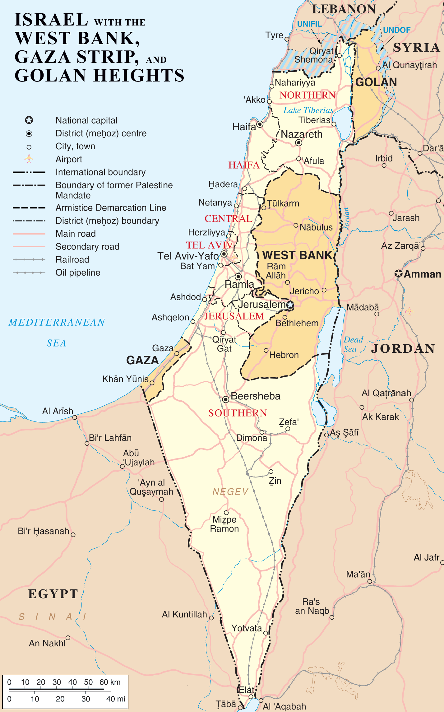
English: Map of Israel, the Palestinian territories (West Bank and Gaza Strip), the Golan Heights, and portions of neighbouring countries. Also United Nations deployment areas in countries adjoining Israel or Israeli-held territory, as of January 2004.
العربية: خريطة إسرائيل والأراضي الفلسطينية (الضفة الغربية وقطاع غزة) ومرتفعات الجولان وأجزاء من الدول المجاورة. وكذلك مناطق انتشار الأمم المتحدة في البلدان المجاورة لإسرائيل أو الأراضي التي تسيطر عليها إسرائيل ، حتى كانون الثاني / يناير 2004. |
| Дата | |
| Ҫӑлкуҫ | http://www.un.org/Depts/Cartographic/map/profile/israel.pdf (heavily modified) |
| Автор | ChrisO |
| Другие версии |
Derivative works of this file: |


Лицензилени
| Public domainPublic domainfalsefalse |
| Автор этого произведения, ChrisO из акӑлчан Википеди, передаёт его в общественное достояние. Это разрешение действует по всему миру. В некоторых странах это не может быть возможно юридически, в таком случае: ChrisO предоставляет любому право использовать данное произведение в любых целях, без каких-либо условий, если только такие условия не требуются по закону.Public domainPublic domainfalsefalse |
| Public domainPublic domainfalsefalse |
| This image is a map derived from a United Nations map.
Unless stated otherwise, UN maps are to be considered in the public domain. This applies worldwide. UN maps are, in principle, open source material and you can use them in your work or for making your own map. UN requests however that you delete the UN name, logo and reference number upon any modification to the map. Content of your map will be your responsibility. You can state in your publication, if you wish, something like: based on UN map … (map name, map number, revision number and date). See: Geospatial Information Section. And: Geospatial, location data for a better world. |
 |
Исходный журнал загрузок
- 2007-04-03 22:53 ChrisO 1428×2289×8 (264824 bytes) == Summary == {{Information |Description= {{en|Map of [[Israel]], the [http://en.wikipedia.org/wiki/Palestinian_territories Palestinian territories] ([[West Bank]] and [[Gaza Strip]]), the [[Golan Heights]], and portions of neighbouring countries. Also [[
Краткие подписи
Элементы, изображённые на этом файле
изображённый объект вырӑс
3 Ака уйӑхӗн 2007
Файл историйĕ
Вӑхӑт ҫине пуссан, ун чухнехи версине пӑхма пулать.
| Дата/Вăхăт | Миниатюра | Калӑпӑш | Хутшăнакан | Асăрхав | |
|---|---|---|---|---|---|
| хальхи | 10:54, 12 Пуш уйӑхӗн 2012 | | 1428 × 2289 (259 КБ) | Ayin leZion | Marked J'lem as capital according to en:Israel |
| 08:22, 11 Ака уйӑхӗн 2007 |  | 1428 × 2289 (259 КБ) | Liftarn | {{Information |Description=Map of Israel, the Palestinian territories (West Bank and Gaza Strip), the Golan Heights, and portions of neighbouring countries. Also United Nations deployment areas in countries adjoining Israel or Israeli-held territory, as o |
Файлпа усă курни
Ку файлпа ҫак 2 страницӑра усӑ курнӑ:
Файлпа глобаллӑ усӑ курасси
Ку файлпа ҫак викисенче усӑ курнӑ:
- ar.wikipedia.org усӑ курасси
- as.wikipedia.org усӑ курасси
- be.wikipedia.org усӑ курасси
- bg.wikipedia.org усӑ курасси
- bn.wikipedia.org усӑ курасси
- cs.wikipedia.org усӑ курасси
- de.wikipedia.org усӑ курасси
- dty.wikipedia.org усӑ курасси
- en.wikipedia.org усӑ курасси
- History of the Israeli–Palestinian conflict
- Isratin
- History of Palestine
- Palestinian rocket attacks on Israel
- User:Mr.Z-man/norefs
- User:Mr.Z-man/withrefs
- Wikipedia:Wikipedia Signpost/2014-07-30/Traffic report
- Wikipedia:Wikipedia Signpost/Single/2014-07-30
- Wikipedia:Top 25 Report/July 20 to 26, 2014
- Wikipedia:Top 25 Report/July 27 to August 2, 2014
- Wikipedia:Top 25 Report/August 3 to 9, 2014
- Talk:Israel/Archive 49
- Foreign policy of Donald Trump during the 2016 presidential election
- User:Falcaorib/Israel and Palestine
- es.wikipedia.org усӑ курасси
- fa.wikipedia.org усӑ курасси
- fi.wikipedia.org усӑ курасси
- fr.wikipedia.org усӑ курасси
- hi.wikipedia.org усӑ курасси
- hi.wiktionary.org усӑ курасси
- hu.wikipedia.org усӑ курасси
- hy.wikipedia.org усӑ курасси
Ку файлпа глобальлӗ епле усӑ курнине пӑх.
Метаданнăйсем:
Файлта цифра камерӑсем е сканерсем хушакан хушма даннӑйсем пур. Хатӗрленӗ хыҫҫӑн файла редакциленӗ пулсан хӑш-пӗр параметрсем хальхи сӑнрипе пӗр килмесӗр пултараҫҫӗ.
| Горизонтальное разрешение | 28,35 точек на сантиметр |
|---|---|
| Вертикальное разрешение | 28,35 точек на сантиметр |
| Дата и время изменения файла | 10:51, 12 Пуш уйӑхӗн 2012 |