Soubor:Is-wb-gs-gh_v3.png
From Wikipedia, the free encyclopedia
Původní soubor (1 428 × 2 289 pixelů, velikost souboru: 259 KB, MIME typ: image/png)
| Tento soubor pochází z Wikimedia Commons. Níže jsou zobrazeny informace, které obsahuje jeho tamější stránka s popisem souboru. |
Popis
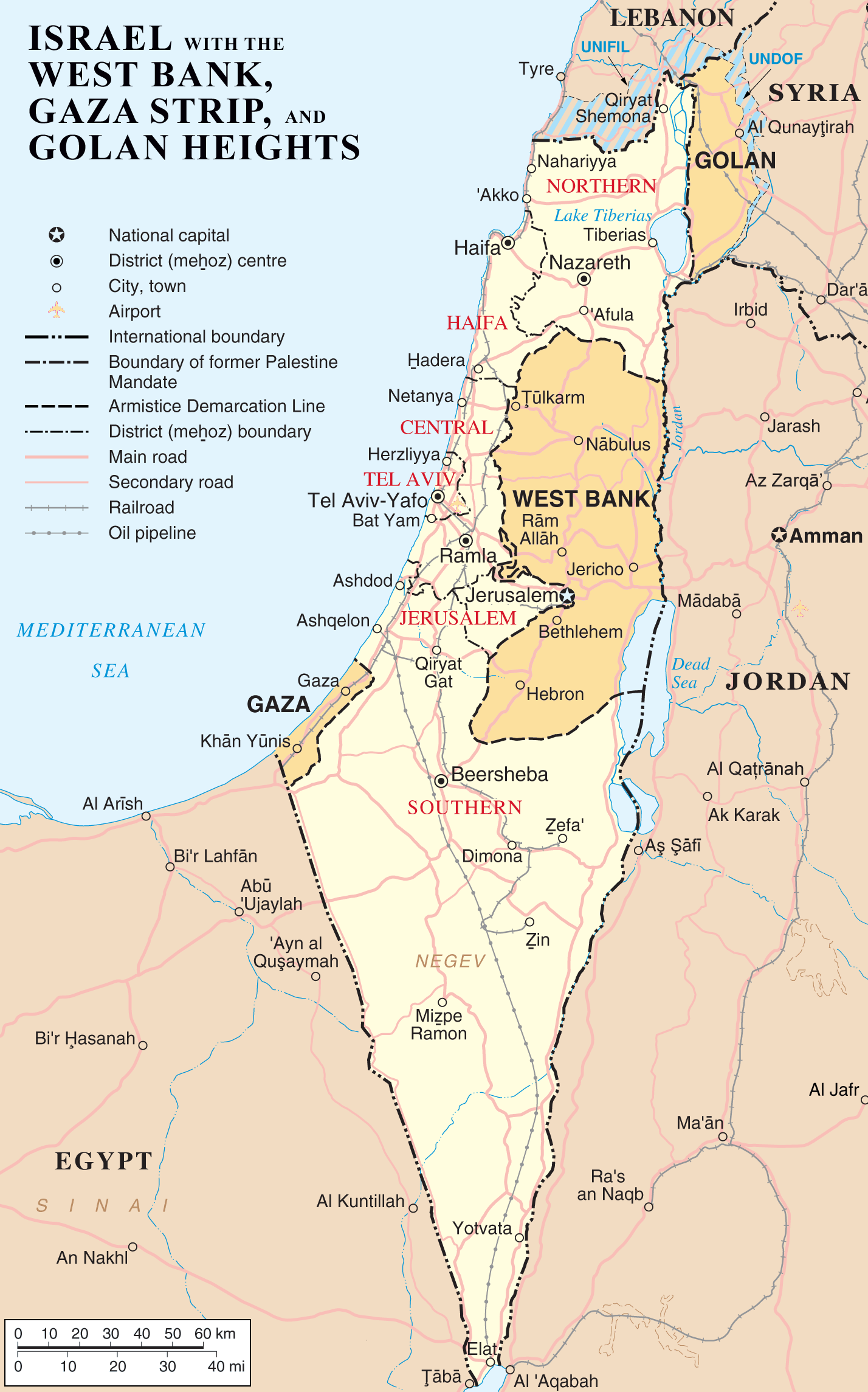
| PopisIs-wb-gs-gh v3.png |
English: Map of Israel, the Palestinian territories (West Bank and Gaza Strip), the Golan Heights, and portions of neighbouring countries. Also United Nations deployment areas in countries adjoining Israel or Israeli-held territory, as of January 2004.
العربية: خريطة إسرائيل والأراضي الفلسطينية (الضفة الغربية وقطاع غزة) ومرتفعات الجولان وأجزاء من الدول المجاورة. وكذلك مناطق انتشار الأمم المتحدة في البلدان المجاورة لإسرائيل أو الأراضي التي تسيطر عليها إسرائيل ، حتى كانون الثاني / يناير 2004. |
| Datum | |
| Zdroj | http://www.un.org/Depts/Cartographic/map/profile/israel.pdf (heavily modified) |
| Autor | ChrisO |
| Další verze |
Díla odvozená od tohoto souboru: |


Licence
| Public domainPublic domainfalsefalse |
| ChrisO na projektu Wikipedie v jazyce angličtina, autor tohoto díla, jej uvolnil jako volné dílo, a to celosvětově. V některých zemích to není podle zákona možné; v takovém případě: ChrisO poskytuje komukoli právo užívat toto dílo za libovolným účelem, a to bezpodmínečně s výjimkou podmínek vyžadovaných zákonem.Public domainPublic domainfalsefalse |
| Public domainPublic domainfalsefalse |
| This image is a map derived from a United Nations map.
Unless stated otherwise, UN maps are to be considered in the public domain. This applies worldwide. UN maps are, in principle, open source material and you can use them in your work or for making your own map. UN requests however that you delete the UN name, logo and reference number upon any modification to the map. Content of your map will be your responsibility. You can state in your publication, if you wish, something like: based on UN map … (map name, map number, revision number and date). See: Geospatial Information Section. And: Geospatial, location data for a better world. |
 |
Původní historie souboru
- 2007-04-03 22:53 ChrisO 1428×2289×8 (264824 bytes) == Summary == {{Information |Description= {{en|Map of [[Israel]], the [http://en.wikipedia.org/wiki/Palestinian_territories Palestinian territories] ([[West Bank]] and [[Gaza Strip]]), the [[Golan Heights]], and portions of neighbouring countries. Also [[
Popisky
Položky vyobrazené v tomto souboru
zobrazuje
3. 4. 2007
Historie souboru
Kliknutím na datum a čas se zobrazí tehdejší verze souboru.
| Datum a čas | Náhled | Rozměry | Uživatel | Komentář | |
|---|---|---|---|---|---|
| současná | 12. 3. 2012, 12:54 | | 1 428 × 2 289 (259 KB) | Ayin leZion | Marked J'lem as capital according to en:Israel |
| 11. 4. 2007, 10:22 |  | 1 428 × 2 289 (259 KB) | Liftarn | {{Information |Description=Map of Israel, the Palestinian territories (West Bank and Gaza Strip), the Golan Heights, and portions of neighbouring countries. Also United Nations deployment areas in countries adjoining Israel or Israeli-held territory, as o |
Využití souboru
Tento soubor používá následujících 8 stránek:
Globální využití souboru
Tento soubor využívají následující wiki:
- Využití na ar.wikipedia.org
- Využití na as.wikipedia.org
- Využití na be.wikipedia.org
- Využití na bg.wikipedia.org
- Využití na bn.wikipedia.org
- Využití na cv.wikipedia.org
- Využití na de.wikipedia.org
- Využití na dty.wikipedia.org
- Využití na en.wikipedia.org
- History of the Israeli–Palestinian conflict
- Isratin
- History of Palestine
- Palestinian rocket attacks on Israel
- User:Mr.Z-man/norefs
- User:Mr.Z-man/withrefs
- Wikipedia:Wikipedia Signpost/2014-07-30/Traffic report
- Wikipedia:Wikipedia Signpost/Single/2014-07-30
- Wikipedia:Top 25 Report/July 20 to 26, 2014
- Wikipedia:Top 25 Report/July 27 to August 2, 2014
- Wikipedia:Top 25 Report/August 3 to 9, 2014
- Talk:Israel/Archive 49
- Foreign policy of Donald Trump during the 2016 presidential election
- User:Falcaorib/Israel and Palestine
- Využití na es.wikipedia.org
- Využití na fa.wikipedia.org
- Využití na fi.wikipedia.org
- Využití na fr.wikipedia.org
- Využití na hi.wikipedia.org
- Využití na hi.wiktionary.org
- Využití na hu.wikipedia.org
- Využití na hy.wikipedia.org
- Využití na hyw.wikipedia.org
- Využití na is.wikipedia.org
- Využití na it.wikipedia.org
Zobrazit další globální využití tohoto souboru.
Metadata
Tento soubor obsahuje dodatečné informace, poskytnuté zřejmě digitálním fotoaparátem nebo scannerem, kterým byl pořízen. Pokud byl soubor od té doby změněn, některé údaje mohou být neplatné.
| Rozlišení obrázku na šířku | 28,35 dpc |
|---|---|
| Rozlišení obrázku na výšku | 28,35 dpc |
| Datum a čas vytvoření obrázku | 12. 3. 2012, 10:51 |