File:Militargrenze,_Wojwodowena_und_Banat.jpg
維基百科,自由的 encyclopedia
預覽大小:800 × 277 像素。 其他解析度:320 × 111 像素 | 900 × 312 像素。
原始檔案 (900 × 312 像素,檔案大小:115 KB,MIME 類型:image/jpeg)
| 描述Militargrenze, Wojwodowena und Banat.jpg |
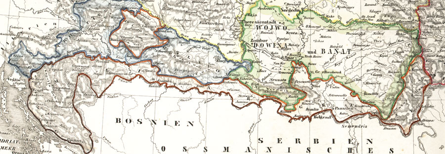
Deutsch: Karte der österreichischen Militärgrenze aus dem 19. Jahrhundert.
English: Historic map of the military frontier of Austria-Hungary, also named Krajina, and of Vojvodina
Français : Carte historique des confins militaires en Autriche-Hongrie aussi appelé Krajina |
|||||
| 日期 | 2004 | |||||
| 來源 | de:Bild:Militärgrenze.jpg | |||||
| 作者 | Scan plp | |||||
| 授權許可 (重用此檔案) |
|
|||||
| 其他版本 |
 |
|||||
| 註解 InfoField | 該圖片含有註解:在維基媒體共享資源上查看註解 |
232
233
172
29
900
312
Bosnia
514
271
246
26
900
312
Serbia
312
289
496
21
900
312
Ottoman Empire
說明
添加單行說明來描述出檔案所代表的內容
在此檔案描寫的項目
描繪內容
多媒體型式 繁體中文 (已轉換拼寫)
image/jpeg
檔案歷史
點選日期/時間以檢視該時間的檔案版本。
| 日期/時間 | 縮圖 | 尺寸 | 用戶 | 備註 | |
|---|---|---|---|---|---|
| 目前 | 2008年9月26日 (五) 04:57 | 900 × 312(115 KB) | Nikola Smolenski | {{Information |Description={{de|Karte der österreichischen de:Militärgrenze aus dem 19. Jahrhundert.}} {{en|Historic map of the military frontier of Austria-Hungary, also named w:Krajina, and of w:Vojvodina}} {{fr|Carte historique des con |
檔案用途
下列3個頁面有用到此檔案:
全域檔案使用狀況
以下其他 wiki 使用了這個檔案:
- azb.wikipedia.org 的使用狀況
- be-tarask.wikipedia.org 的使用狀況
- bg.wikipedia.org 的使用狀況
- bs.wikipedia.org 的使用狀況
- cs.wikipedia.org 的使用狀況
- da.wikipedia.org 的使用狀況
- de.wikipedia.org 的使用狀況
- en.wikipedia.org 的使用狀況
- eo.wikipedia.org 的使用狀況
- es.wikipedia.org 的使用狀況
- et.wikipedia.org 的使用狀況
- fa.wikipedia.org 的使用狀況
- fr.wikipedia.org 的使用狀況
- gl.wikipedia.org 的使用狀況
- hr.wikipedia.org 的使用狀況
- hu.wikipedia.org 的使用狀況
- id.wikipedia.org 的使用狀況
- it.wikipedia.org 的使用狀況
- ja.wikipedia.org 的使用狀況
檢視此檔案的更多全域使用狀況。
詮釋資料
此檔案中包含擴展的資訊。這些資訊可能是由數位相機或掃描器在建立時或數位化過程中所加入。
如果此檔案的來源檔案已被修改,一些資訊在修改後的檔案中將不能完全反映出來。
| _error | 0 |
|---|