దస్త్రం:Map_of_Vedic_India.png
From Wikipedia, the free encyclopedia
మరింత స్పష్టమైన బొమ్మ లేదు.
Map_of_Vedic_India.png (683 × 489 పిక్సెళ్ళు, ఫైలు పరిమాణం: 424 KB, MIME రకం: image/png)
This is a file from the Wikimedia Commons. Information from its description page there is shown below. Commons is a freely licensed media file repository. You can help. |
Dbachmann, ఈ కృతి యొక్క కాపీహక్కుదారు, దీన్ని ఇందుమూలముగా ఈ లైసెన్సు క్రింద ప్రచురిస్తున్నారు:

|
ఈ కృతి యొక్క కర్తనైన నేను, ఇక నుండీ ఈ కృతిని కాపీ చేసుకోవడానికి, పంచి పెట్టడానికి మరియు/లేదా మార్పులు-చేర్పులు చేసుకోవడానికి GFDL, లైసెన్సు వెర్షను 1.2 లేదా దాని తరువాత స్వేచ్చా సాఫ్టువేరు ఫౌండేషను విడుదలచేసే ఏ GFDL లైసెన్సు ద్వారా నయినా అనుమతి ఇస్తున్నాను; ఈ కృతిలో మార్చకూడని బాగాలు లేవు, Front-Cover పాఠం లేదు, Back-Cover పాఠం లేదు. ఈ లైసెన్సు యొక్క పత్రం నకలును "జిఎన్యూ ఉచిత డాక్యుమెంటేషను లైసెన్సు" అని పిలుస్తున్న విభాగంలో ఉంది.http://www.gnu.org/copyleft/fdl.htmlGFDLGNU Free Documentation Licensetruetrue |
| ఈ దస్త్రం క్రియేటివ్ కామన్స్ Attribution-Share Alike 3.0 Unported లైసెన్సు క్రింద లభ్యం. | ||
| ఆపాదింపు: Dbachmann | ||
| ||
| GFDL లైసెన్సు తాజాకరణలో భాగంగా ఈ దస్త్రానికి ఈ లైసెన్సింగు ట్యాగుని చేర్చారు.http://creativecommons.org/licenses/by-sa/3.0/CC BY-SA 3.0Creative Commons Attribution-Share Alike 3.0truetrue |
derivative works
Derivative works of this file: Map of Vedic India ru.png
Captions
Add a one-line explanation of what this file represents
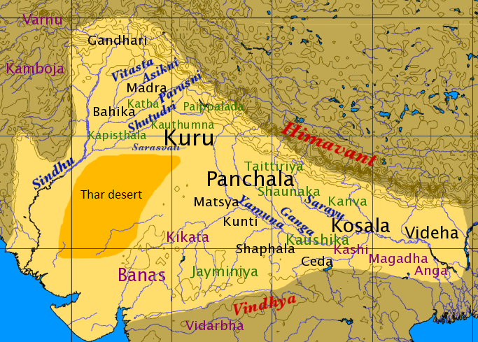
''Āryāvarta'' during the Mahajanapadas era (c. 600-300 BC)
စန္ဒသူရိယ
Items portrayed in this file
చిత్రణ
Buddhism in Thailand ఇంగ్లీష్
copyright status ఇంగ్లీష్
copyrighted ఇంగ్లీష్
media type ఇంగ్లీష్
image/png
ఫైలు చరితం
తేదీ/సమయం ను నొక్కి ఆ సమయాన ఫైలు ఎలా ఉండేదో చూడవచ్చు.
| తేదీ/సమయం | నఖచిత్రం | కొలతలు | వాడుకరి | వ్యాఖ్య | |
|---|---|---|---|---|---|
| ప్రస్తుత | 13:59, 18 ఫిబ్రవరి 2016 | | 683 × 489 (424 KB) | Mywikicommons | Reverted to version as of 13:48, 18 February 2016 (UTC) |
| 13:59, 18 ఫిబ్రవరి 2016 |  | 683 × 489 (424 KB) | Mywikicommons | Reupload - Minor addition : Thar Desert (text) added to map according to already given sources. | |
| 13:48, 18 ఫిబ్రవరి 2016 |  | 683 × 489 (424 KB) | Mywikicommons | Minor addition : Thar Desert (text) added to map according to already given sources. | |
| 11:04, 22 ఆగస్టు 2005 |  | 683 × 489 (353 KB) | Dbachmann | by en:User:Dbachmann {{GFDL}} |
లింకులు
కింది పేజీలలో ఈ ఫైలుకు లింకులు ఉన్నాయి:
సార్వత్రిక ఫైలు వాడుక
ఈ దస్త్రాన్ని ఈ క్రింది ఇతర వికీలు ఉపయోగిస్తున్నాయి:
- af.wikipedia.org లో వాడుక
- als.wikipedia.org లో వాడుక
- anp.wikipedia.org లో వాడుక
- ar.wikipedia.org లో వాడుక
- ast.wikipedia.org లో వాడుక
- az.wikipedia.org లో వాడుక
- bg.wikipedia.org లో వాడుక
- bh.wikipedia.org లో వాడుక
- bn.wikipedia.org లో వాడుక
- ca.wikipedia.org లో వాడుక
- cs.wikipedia.org లో వాడుక
- de.wikipedia.org లో వాడుక
- el.wikipedia.org లో వాడుక
- en.wikipedia.org లో వాడుక
ఈ దస్త్రపు మరింత సార్వత్రిక వాడుకను చూడండి.
మెటాడేటా
ఈ ఫైలులో అదనపు సమాచారం ఉంది, బహుశా దీన్ని సృష్టించడానికి లేదా సాంఖ్యీకరించడానికి వాడిన డిజిటల్ కేమెరా లేదా స్కానర్ ఆ సమాచారాన్ని చేర్చివుండవచ్చు. ఈ ఫైలును అసలు స్థితి నుండి మారిస్తే, ఆ మారిన ఫైలులో కొన్ని వివరాలు పూర్తిగా ప్రతిఫలించకపోవచ్చు.
| క్షితిజసమాంతర స్పష్టత | 78.74 dpc |
|---|---|
| లంబ స్పష్టత | 78.74 dpc |
| ఫైలు మార్చిన తేదీ, సమయం | 11:03, 22 ఆగస్టు 2005 |
"https://te.wikipedia.org/wiki/దస్త్రం:Map_of_Vedic_India.png" నుండి వెలికితీశారు