グレートフォールズ (モンタナ州)
アメリカ合衆国モンタナ州の都市 ウィキペディアから
グレートフォールズ(英: Great Falls)は、アメリカ合衆国モンタナ州カスケード郡の都市であり、同郡の郡庁所在地である。人口は6万442人(2020年国勢調査)で州内第3の都市である。カスケード郡全体を含むグレートフォールズ都市圏の中心都市である。グレートフォールズという名前は、1805年から1806年に挙行されたルイス・クラーク探検隊で16キロメートルの距離を31日間も掛けて陸路を進まなければならなかった一連の5つの滝に因むものである。その陸路のうち2カ所の未開発部はグレートフォールズ・ポーテージに含まれ国定歴史史跡に登録されている。
| グレートフォールズ City of Great Falls, Montana | |
|---|---|
 シビック・センター | |
| 愛称 : 電気の都市 | |
| 位置 | |
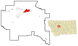
 カスケード郡内の位置 | |
| 座標 : 北緯47度30分13秒 西経111度17分11秒 | |
| 行政 | |
| 国 | アメリカ合衆国 |
| 州 | モンタナ州 |
| 郡 | カスケード郡 |
| 市 | グレートフォールズ City of Great Falls, Montana |
| 市長 | マイケル・ウィンターズ |
| 地理 | |
| 面積 | |
| 市域 | 51.6 km2 (19.9 mi2) |
| 陸上 | 50.5 km2 (19.5 mi2) |
| 水面 | 1.1 km2 (0.4 mi2) |
| 水面面積比率 | 1.32% |
| 都市圏 | 13,923 km2 (5,376 mi2) |
| 標高 | 1,015 m (3,330 ft) |
| 人口 | |
| 人口 | (2020年現在) |
| 市域 | 60,442人 |
| 人口密度 | 1171人/km2 |
| 都市圏 | 84,414人 |
| その他 | |
| 等時帯 | 山岳部標準時 (UTC-7) |
| 夏時間 | 山岳部夏時間 (UTC-6) |
| 公式ウェブサイト : City of Great Falls | |
市内にはC・M・ラッセル博物館複合施設、グレートフォールズ大学、ジャイアント・スプリングズ、ロー川(61メートルで世界最短の川)およびモンタナ視聴覚障害者学校があり、またマイナーリーグ野球のグレートフォールズ・ボイジャーズ(元はグレートフォールズ・ホワイトソックス)が本拠地にしている。地元の新聞は「グレートフォールズ・トリビューン」である。グレートフォールズにはミズーリ川に沿って近在に5カ所の水力発電ダムがあるため「電気の都市」と呼ばれている。
コールドウエルバンカー住宅価格比較指数では全米とプエルトリコを含め348の市場で、グレートフォールズは最も手頃な地域となっている。
歴史
要約
視点

グレートフォールズ地域に最初に住んだ人類は紀元前9500年から同8270年の間に移り住んできたパレオ・インディアンだった[1][2]。北アメリカ最初期の住人が山岳とローレンタイド氷河の間にある大陸分水界東のモンタナに入った[3]。しかし、この地域の人口は希薄な状態が続いた[4]。セイリッシュ族インディアンが季節によってこの地域にアメリカバイソンを狩りにくることが多かったが、先史時代はグレートフォールズ周辺に恒久的な居住地は無かった[4]。西暦1600年頃、ピーガン・ブラックフット族インディアンが西に移ってきて、セイリッシュ族インディアンをロッキー山脈に押し戻し、現在のグレートフォールズ地域の領有を主張した[4]。アメリカ合衆国が1803年にルイジアナ買収を行った時まで、この地域はブラックフット族インディアンの領地だった[5][6]。
ルイス・クラーク探検隊を率いたメリウェザー・ルイスが1805年6月13日にここを訪れたのが最初の白人の到着だった[7][8]。ウィリアム・クラークが所有しており、この探検隊に参加していたアフリカ系アメリカ人奴隷ヨークがこの地域を訪れた最初の黒人だった[9]。
1806年にルイス・クラーク探検隊が帰還した後[10]、1822年に探検家で罠猟師であるジム・ブリッジャーが訪れるまで、この地域を訪れた白人の記録は無い[5]。ブリッジャーとアンドリュー・ヘンリー少佐が1823年4月に毛皮交易業者の遠征隊を率いてこの地域に入り、キャンプをしているときにブラックフット族インディアンに襲われた[11]。イギリス人探検家アレクサンダー・ロスが1824年にここで罠を仕掛けた[12]。1838年、アメリカ合衆国政府が派遣し、ブリッジャーが案内した地図制作遠征隊がこの地域で4年間を過ごした[5]。1862年、マーガレット・ハークネス・ウッドマンがグレートフォールズを訪れた最初の白人女性になった[13]。


グレートフォールズはミズーリ川の航行可能な限界点であり[14]、1859年に最初の蒸気船がここを訪れた[15]。
後にグレートフォールズ市となる場所は19世紀の間、行政的に多様な区画に含まれており、1854年5月30日にネブラスカ準州が設立されるまで未編入のフロンティアだった[16]。1855年にアイザック・スティーブンスがインディアンとヘルゲート条約を結んだ後は、インディアンによる白人探検家や開拓者への攻撃が著しく減り、この地域に白人開拓地が造られ始めた[5]。1861年3月2日、この地域はダコタ準州の一部になった[17]。1863年3月4日にはアイダホ準州に編入された[18]。1864年5月28日にモンタナ準州となった[4]。1889年11月8日にモンタナはアメリカ合衆国の州に昇格した。
グレートフォールズの町は1883年に設立された。事業家パリス・ギブソンが1880年にミズーリ川のグレートフォールズ(滝)を訪れ、水力発電が可能な滝の近くに大きな工業都市を建設できる可能性に心を動かされた[19][20][21][22]。ギブソンは1883年に測量士を伴ってこの地を再訪し、川の南岸で恒久的開拓地の区画図を造った[5][19][20]。その年後半に最初の住人サイラス・ビーチリーが到着した[5]。鉄道会社オーナーのジェイムズ・J・ヒルや州都ヘレナの事業家チャールズ・アーサー・ブロードウォーターからの投資で、1884年に家屋、店舗および製粉所が建てられた[5][19][20][21][22]。1884年7月10日にグレートフォールズ郵便局が造られ、パリス・ギブソンが初代郵便局長に指名された[23]。1855年には製材所、貯木場、銀行、学校および新聞社ができた[19][22]。1887年までに市内人口は1,200人となり、この年10月にはグレート・ノーザン鉄道が開通した[19][21][22]。グレートフォールズは1888年11月28日に自治体として編入された。
1890年にブラックイーグル・ダムが建設され、1912年までにレインボー・ダムやボルタ・ダム(現在のライアン・ダム)が運用された[5][19][22]。
グレートフォールズは急速に工業と物流の中心として発展し、1900年代初期までにモンタナ州では最大級の都市になるところだった。西部開拓時代の有名画家チャールズ・マリオン・ラッセルの鄙びたスタジオが人気を呼び、名画『ミズーリ川のグレートフォールズ』があったので、これが市の名前になった。市内最大の雇用主アナコンダ銅山会社の製錬所に高さ508フィート (155 m) と「世界最高の煙突」が1908年に完成した。この煙突は直ぐに地域社会の目印になったが、1983年に老朽化のために解体された。しかし、解体にあたった作業者達は最初の試みではそれを成し遂げられず、半分程残ったままになった。数日後解体班が戻ってきて解体を完了した。
1940年代に近くに軍隊の基地ができてグレートフォールズはさらに繁栄したが、20世紀後半は鉄道や貨物の輸送が衰退し、周辺の農業地域の人口も減少し、1980年代には精錬所は閉鎖しマルムストローム空軍基地も縮小され、人口の成長が止まった。
グレートプレーンズやアメリカ合衆国中西部の多くの都市と同様、グレートフォールズの経済は近年の工業地帯の衰退による苦しみを味わっている。
地理と気候
要約
視点


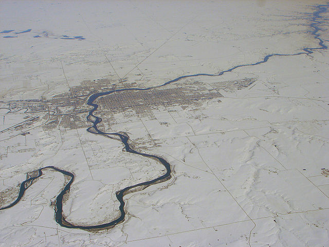
グレートフォールズは北緯47度30分13秒 西経111度17分11秒に位置し、近くにはミズーリ川の滝が幾つかある。グレートプレーンズ北部にあるモンタナ州に中心に近く、カナダ国境からは南に約100マイル (160 km) の距離にある。
グレートフォールズ市はグレートフォールズ構造プレートの上にある。このプレートは北アメリカ大陸の一部を形成した太古代期の2つの地質区基盤岩間の大陸内せん断帯である[24]。グレートフォールズは、最終氷期に北アメリカの大半を覆ったローレンタイド氷河の南端にあたっている。約150万年前、ミズーリ川は北に流れて内陸湖に流れ込んでいた[25][26]。ローレンタイド氷河がその流れを南に押しやった[25][27]。紀元前15000年から同11000年にローレンタイド氷河がミズーリ川を堰き止め、氷河湖グレートフォールズを造った[27][28][1]。紀元前13000年頃、氷河が後退し、氷河湖グレートフォールズは氷河湖決壊洪水で破壊的に水が無くなった[1]。現在のミズーリ川の流れは基本的にローレンタイド氷河の南縁に沿っている[29]。ミズーリ川は氷河を東に回り込み、現在の流れになった[25]。氷河が後退すると、氷河湖グレートフォールズから出た水はハイウッド山脈を抜けて、世界でも有名な前史溶融水浸食渓谷である深さ500フィート (150 m) の長いショーキン・サッグを形成した[30]。
グレートフォールズはグレートフォールズ構造プレートの不整合滝線上にある[31]。また過去に川、氷河および湖によって海洋性ではない砂岩が層になったクーテネー地層の上にある[32][33]。
チヌーク(冬に吹き下りる暖かい風で気温を急激に上げる)のお陰で、冬のグレートフォールズは比較的暖かいが、風がないときは−20°F (−29℃)以下の極低温になることがよくある。年間降水量は12インチ (305 mm) あり、その多くは夏の雷雨と冬の降雪である。
アメリカ合衆国国勢調査局に拠れば、市域全面積は19.9平方マイル (51.6 km2)、このうち陸地は19.5平方マイル (50.5 km2)、水面は0.4平方マイル (1.1 km2)で水域率は2.21%である。
| グレートフォールズの気候 | |||||||||||||
|---|---|---|---|---|---|---|---|---|---|---|---|---|---|
| 月 | 1月 | 2月 | 3月 | 4月 | 5月 | 6月 | 7月 | 8月 | 9月 | 10月 | 11月 | 12月 | 年 |
| 最高気温記録 °C (°F) | 19 (67) |
21 (70) |
26 (78) |
32 (89) |
34 (93) |
38 (101) |
41 (105) |
41 (106) |
37 (98) |
33 (91) |
24 (76) |
21 (69) |
41 (106) |
| 平均最高気温 °C (°F) | 0.1 (32.1) |
3.2 (37.7) |
7.4 (45.3) |
13.1 (55.6) |
18.2 (64.7) |
23.3 (73.9) |
27.8 (82.0) |
27.3 (81.2) |
20.9 (69.6) |
14.4 (58.0) |
5.6 (42.1) |
1.2 (34.2) |
13.6 (56.4) |
| 平均最低気温 °C (°F) | −11.5 (11.3) |
−9.4 (15.1) |
−5.8 (21.5) |
−1.3 (29.7) |
3.5 (38.3) |
7.8 (46.0) |
10.2 (50.4) |
9.9 (49.9) |
5.1 (41.2) |
0.6 (33.0) |
−5.3 (22.5) |
−9.8 (14.4) |
−0.5 (31.1) |
| 最低気温記録 °C (°F) | −38 (−37) |
−37 (−35) |
−34 (−29) |
−21 (−6) |
−9 (15) |
−1 (31) |
2 (36) |
−1 (30) |
−9 (16) |
−24 (−11) |
−32 (−25) |
−42 (−43) |
−42 (−43) |
| 降水量 mm (inch) | 17.3 (0.68) |
13 (0.51) |
25.7 (1.01) |
35.6 (1.40) |
64.3 (2.53) |
56.9 (2.24) |
36.8 (1.45) |
41.9 (1.65) |
31.2 (1.23) |
23.6 (0.93) |
15 (0.59) |
17 (0.67) |
378.2 (14.89) |
| 出典:USTravelWeather.com [34] | |||||||||||||
人口動態
以下は2000年の国勢調査による人口統計データである。
|
基礎データ
人種別人口構成
年齢別人口構成
|
世帯と家族(対世帯数)
収入収入と家計 |
教育
グレートフォールズ教育学区には20の学校がある。高校2校、オールタナティブ高校1校、中学校2校[38]および小学校15校である[39]。
公立高校はグレートフォールズ高校とチャールズ・マリオン・ラッセル高校であり、オールタナティブ高校はパリス・ギブソン教育センターである。
メディア
グレートフォールズで発行される新聞は「グレートフォールズ・トリビューン」である。ラジオ局としてはAM4局、FM13局がある。
軍隊
グレートフォールズにはマルムストローム空軍基地と第341ミサイル航空団がある。第341作戦群はその航空団の大陸間弾道ミサイル(ICBM)の発射、モニターし確保する部隊と、ミサイル警戒施設(MAF)を運用する部隊を抱えている。
このICBMとMAFは西半球では最大の23,000平方マイル (59,570 km2)、ウェストバージニア州の大きさに匹敵するミサイル複合施設にばらまかれている。
このグループは50億ドル以上に相当する様々な装置、施設および車両を運用している。
グレートフォールズ国際空港はモンタナ州空軍州兵の第120戦闘機航空団の基地でもある。この航空団はF-15イーグル戦闘機とこれに関連するサポート要員で構成されている。
グレートフォールズには第889アメリカ陸軍予備役隊もいる。
警察
グレートフォールズ警察署は市の法律を執行させる機関である。ここには82名の宣誓した男女と37名の市民支援スタッフがいる。特殊部隊など多くの支部もある[40]。
パトロール部門には49名の警官がおり、4シフトで勤務している。2005年には32,823回のコールに応じた。3つのパトロール隊があり、1人の中尉、2人の軍曹、および10人の警官で構成されている[41]。3匹の警察犬がおり、すべてオランダから連れてきた。ドラッグの発見や容疑者の識別に使われている[42]。バイク・パトロールは4名の警官がおり、主にマウンテンバイクを使って中心街をパトロールしている。特別機動隊は危険な状況に対応できるよう訓練されている。
警察署は1888年に設立された。ジョージ・E。ヒューイが初代巡査長になった。当時は警官2人だった。制服が無かったので平服を着ていた。1914年に自動車を導入し、1940年に送受信兼用の無線機を、1970年にコンピュータを入れた。現在自動車は65台ある。
現在の警察署長はクロイド・"コーキー"・グローブである[43]。
スポーツ
1979年から1980年にアイスホッケーシーズンには、グレートフォールズのフォーシーズンズ・アリーナがグレートフォールズ・アメリカンズの本拠地になった。このチームの戦績は2勝25敗で、その後にチームを畳んだ。グレートフォールズはボイジャーズと共に野球の豊富な歴史がある。以前はホワイトソックス、ドジャースおよびジャイアンツとも呼ばれ、ペドロ・マルティネス、ホセ・オファーマンおよびラウル・モンデシーのような大リーグ選手がグレートフォールズでプレイしたことがあった。1988年以降、パイオニアリーグで5度優勝した。2007年、バスケットボールのグレートフォールズ・イクスプローラーズがCBAナショナル・カンファランスで2位になった。
マリアナUFO事件
→詳細は「マリアナUFO事件」を参照
1950年8月に、地元野球チームのグレートフォールズ・セレクトリックスでゼネラルマネージャーを務めていたニック・マリアナが、チームの本拠地であるレギオン・スタジアム(現センティーン・スタジアム)にいたときに市の上空を飛行する正体不明の物体に気づき、16ミリカメラで動画を撮影した。後に未確認飛行物体(UFO)と呼ばれるようになったものを映像として撮影した事例としては最初期のひとつであった。この事件はアメリカ全国で広く報道された。2008年、グレートフォールズの野球チームは、マリアナUFO事件を記念してグレートフォールズ・ボイジャーズとチーム名を改めた。チームのロゴのひとつは、空飛ぶ円盤に緑色のエイリアンが乗っている。
著名出身者と住人
|
|
グレートフォールズで撮影された映画

グレートフォールズ周辺では多くの映画が撮影されている。以下はその主なものである。
- サンダーボルト(1974年)
- Telefon(1977年)
- The Stone Boy(1984年)
- アンタッチャブル(1987年)
- Amazing Grace and Chuck(1987年)
- リバー・ランズ・スルー・イット(1992年)
- Freedom(1994年)
- Holy Matrimony(1994年)
- The Slaughter Rule(2002年)
- ノースフォーク 天使がくれた奇跡(2003年)
- Iron Ridge(2008年)
- The Vessel(2009年)
姉妹都市
グレートフォールズ市は以下の都市と姉妹都市を結んでいる
 ロシア、シャリヤ
脚注
参考文献
外部リンク
Wikiwand - on
Seamless Wikipedia browsing. On steroids.
