Portal:World
Wikipedia portal for content related to the world / From Wikipedia, the free encyclopedia
Portal maintenance status: (No date set)
|
The World Portal


The world is the totality of entities, the whole of reality, or everything that exists. The nature of the world has been conceptualized differently in different fields. Some conceptions see the world as unique while others talk of a "plurality of worlds". Some treat the world as one simple object while others analyze the world as a complex made up of parts.
In scientific cosmology, the world or universe is commonly defined as "[t]he totality of all space and time; all that is, has been, and will be". Theories of modality talk of possible worlds as complete and consistent ways how things could have been. Phenomenology, starting from the horizon of co-given objects present in the periphery of every experience, defines the world as the biggest horizon or the "horizon of all horizons". In philosophy of mind, the world is contrasted with the mind as that which is represented by the mind.
Theology conceptualizes the world in relation to God, for example, as God's creation, as identical to God or as the two being interdependent. In religions, there is a tendency to downgrade the material or sensory world in favor of a spiritual world to be sought through religious practice. A comprehensive representation of the world and our place in it, as is found in religions, is known as a worldview. Cosmogony is the field that studies the origin or creation of the world while eschatology refers to the science or doctrine of the last things or of the end of the world.
In various contexts, the term "world" takes a more restricted meaning associated, for example, with the Earth and all life on it, with humanity as a whole or with an international or intercontinental scope. In this sense, world history refers to the history of humanity as a whole and world politics is the discipline of political science studying issues that transcend nations and continents. Other examples include terms such as "world religion", "world language", "world government", "world war", "world population", "world economy", or "world championship". (Full article...)
Selected articles - show another
 Image 1Globalism has multiple meanings. In political science, it is used to describe "attempts to understand all of the interconnections of the modern world—and to highlight patterns that underlie (and explain) them". While primarily associated with world-systems, it can be used to describe other global trends. The concept of globalism is also classically used to focus on ideologies of globalization (the subjective meanings) instead of its processes (the objective practices); in this sense, "globalism" is to globalization what "nationalism" is to nationality.
The term is now frequently used as a pejorative by far-right movements and conspiracy theorists, as in the New World Order; it is sometimes associated with antisemitism, as antisemites frequently appropriate the term globalist to refer to certain Jews. (Full article...)- Image 2
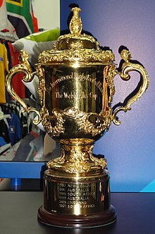 The Webb Ellis Cup, awarded to the winner of men's Rugby World Cup.
The Men's Rugby World Cup is a rugby union tournament contested every four years between the top international teams, the winners of which are recognised as the World champions of the sport.
The tournament is administered by World Rugby, the sport's international governing body. The winners are awarded the Webb Ellis Cup, named after William Webb Ellis who, according to a popular legend, invented rugby by picking up the ball during a football game and running with it. (Full article...) - Image 3

Time zones of the world
A time zone is an area which observes a uniform standard time for legal, commercial and social purposes. Time zones tend to follow the boundaries between countries and their subdivisions instead of strictly following longitude, because it is convenient for areas in frequent communication to keep the same time.
Each time zone is defined by a standard offset from Coordinated Universal Time (UTC). The offsets range from UTC−12:00 to UTC+14:00, and are usually a whole number of hours, but a few zones are offset by an additional 30 or 45 minutes, such as in India and Nepal. Some areas in a time zone may use a different offset for part of the year, typically one hour ahead during spring and summer, a practice known as daylight saving time (DST). (Full article...) - Image 4
The United Nations (UN) is a diplomatic and political international organization whose stated purposes are to maintain international peace and security, develop friendly relations among nations, achieve international cooperation, and serve as a centre for harmonizing the actions of nations. It is the world's largest international organization. The UN is headquartered in New York City, in international territory with certain privileges extraterritorial to the United States, and the UN has other offices in Geneva, Nairobi, Vienna, and The Hague, where the International Court of Justice is headquartered at the Peace Palace.
The UN was established after World War II with the aim of preventing future world wars, and succeeded the League of Nations, which was characterized as ineffective. On 25 April 1945, 50 nations met in San Francisco, California for a conference and started drafting the UN Charter, which was adopted on 25 June 1945. The charter took effect on 24 October 1945, when the UN began operations. The UN's objectives, as defined by its charter, include maintaining international peace and security, protecting human rights, delivering humanitarian aid, promoting sustainable development, and upholding international law. At its founding, the UN had 51 member states; , it has 193 – almost all of the world's sovereign states. (Full article...) - Image 5
 FIFA logo without slogan
The FIFA Women's World Cup is an international association football competition contested by the senior women's national teams of the members of Fédération Internationale de Football Association (FIFA), the sport's international governing body. The competition has been held every four years and one year after the men's FIFA World Cup since 1991, when the inaugural tournament, then called the FIFA Women's World Championship, was held in China. Under the tournament's current format, national teams vie for the remaining 31 slots in a three-year qualification phase. The host nation's team is automatically entered as the first slot. The tournament, called the World Cup Finals, is contested at venues within the host nation(s) over about one month.
The nine FIFA Women's World Cup tournaments have been won by five national teams. The United States have won four times. The other winners are Germany, with two titles, and Japan, Norway, and Spain with one title each. (Full article...) - Image 6

The Space Race was a 20th-century competition between two Cold War rivals, the United States and the Soviet Union, to achieve superior spaceflight capability. It had its origins in the ballistic missile-based nuclear arms race between the two nations following World War II and had its peak with the more particular Moon Race to land on the Moon between the US moonshot and Soviet moonshot programs. The technological advantage demonstrated by spaceflight achievement was seen as necessary for national security and became part of the symbolism and ideology of the time. The Space Race brought pioneering launches of artificial satellites, robotic space probes to the Moon, Venus, and Mars, and human spaceflight in low Earth orbit and ultimately to the Moon.
Public interest in space travel originated in the 1951 publication of a Soviet youth magazine and was promptly picked up by US magazines. The competition began on July 30, 1955, when the United States announced its intent to launch artificial satellites for the International Geophysical Year. Four days later, the Soviet Union responded by declaring they would also launch a satellite "in the near future". The launching of satellites was enabled by developments in ballistic missile capabilities since the end of World War II. The competition gained Western public attention with the "Sputnik crisis", when the USSR achieved the first successful satellite launch, Sputnik 1, on October 4, 1957. It gained momentum when the USSR sent the first human, Yuri Gagarin, into space with the orbital flight of Vostok 1 on April 12, 1961. These were followed by a string of other early firsts achieved by the Soviets over the next few years. (Full article...) - Image 7
The United Nations Educational, Scientific and Cultural Organization (UNESCO; pronounced /juːˈnɛskoʊ/) is a specialized agency of the United Nations (UN) with the aim of promoting world peace and security through international cooperation in education, arts, sciences and culture. It has 194 member states and 12 associate members, as well as partners in the non-governmental, intergovernmental and private sector. Headquartered in Paris, France, UNESCO has 53 regional field offices and 199 national commissions.
UNESCO was founded in 1945 as the successor to the League of Nations' International Committee on Intellectual Cooperation. UNESCO's founding mission, which was shaped by the events of World War II, is to advance peace, sustainable development and human rights by facilitating collaboration and dialogue among nations. It pursues this objective through five major programme areas: education, natural sciences, social/human sciences, culture and communication/information. UNESCO sponsors projects that improve literacy, provide technical training and education, advance science, protect independent media and press freedom, preserve regional and cultural history, and promote cultural diversity. The organization prominently helps establish and secure World Heritage Sites of cultural and natural importance. (Full article...)


General images - load new batch

 Image 2Last Moon landing: Apollo 17 (1972)
 Image 3Change in average surface air temperature and drivers for that change. Human activity has caused increased temperatures, with natural forces adding some variability. (from Earth)

 Image 6Empires of the world in 1898
 Image 8Japanese depiction of a Portuguese carrack. European maritime innovations led to proto-globalization.
 Image 10Pangaea was a supercontinent that existed from about 300 to 180 Ma. The outlines of the modern continents and other landmasses are indicated on this map. (from History of Earth)

 Image 13Notre-Dame de Paris, France
 Image 14Earth's land use for human agriculture in 2019 (from Earth)
 Image 15Great Pyramids of Giza, Egypt
 Image 16Benin Bronze head from Nigeria
 Image 17A pillar at Göbekli Tepe
 Image 18Artist's impression of a Hadean landscape with the relatively newly formed Moon still looming closely over Earth and both bodies sustaining strong volcanism. (from History of Earth)
 Image 20A view of Earth with different layers of its atmosphere visible: the troposphere with its clouds casting shadows, a band of stratospheric blue sky at the horizon, and a line of green airglow of the lower thermosphere around an altitude of 100 km, at the edge of space (from Earth)
 Image 22A reconstruction of human history based on fossil data. (from History of Earth)
 Image 24The pale orange dot, an artist's impression of the early Earth which might have appeared orange through its hazy methane rich prebiotic second atmosphere. Earth's atmosphere at this stage was somewhat comparable to today's atmosphere of Titan. (from History of Earth)
 Image 26A computer-generated image mapping the prevalence of artificial satellites and space debris around Earth in geosynchronous and low Earth orbit (from Earth)
 Image 28A 2012 artistic impression of the early Solar System's protoplanetary disk from which Earth and other Solar System bodies were formed (from Earth)
 Image 30Vitruvian Man by Leonardo da Vinci epitomizes the advances in art and science seen during the Renaissance. (from History of Earth)
 Image 32Angkor Wat temple complex, Cambodia, early 12th century
 Image 33Trilobites first appeared during the Cambrian period and were among the most widespread and diverse groups of Paleozoic organisms. (from History of Earth)
 Image 34Earth's western hemisphere showing topography relative to Earth's center instead of to mean sea level, as in common topographic maps (from Earth)
 Image 35Lithified stromatolites on the shores of Lake Thetis, Western Australia. Archean stromatolites are the first direct fossil traces of life on Earth. (from History of Earth)
 Image 3613th-century French historiated initial with the three classes of medieval society: those who prayed (the clergy), those who fought (the knights), and those who worked (the peasantry) (from Human history)

 Image 39Artist's conception of Hadean Eon Earth, when it was much hotter and inhospitable to all forms of life. (from History of Earth)
 Image 41Fall of the Berlin Wall, 1989
 Image 42Great Mosque of Kairouan, Tunisia, founded 670 CE
 Image 43An artist's impression of the Archean, the eon after Earth's formation, featuring round stromatolites, which are early oxygen-producing forms of life from billions of years ago. After the Late Heavy Bombardment, Earth's crust had cooled, its water-rich barren surface is marked by continents and volcanoes, with the Moon still orbiting Earth half as far as it is today, appearing 2.8 times larger and producing strong tides. (from Earth)
 Image 44Obelisk of Axum, Ethiopia
 Image 46Astronaut Buzz Aldrin on the Moon, photographed by Neil Armstrong, 1969 (from History of Earth)
- Image 47Pale orange dot, an artist's impression of Early Earth, featuring its tinted orange methane-rich early atmosphere (from Earth)
 Image 48A 580 million year old fossil of Spriggina floundensi, an animal from the Ediacaran period. Such life forms could have been ancestors to the many new forms that originated in the Cambrian Explosion. (from History of Earth)
 Image 49Artist's impression of the enormous collision that probably formed the Moon (from History of Earth)
 Image 51"Lucy", the first Australopithecus afarensis skeleton found, was only 1.06 m (3 ft 6 in) tall.
 Image 53A banded iron formation from the 3.15 Ga Moodies Group, Barberton Greenstone Belt, South Africa. Red layers represent the times when oxygen was available; gray layers were formed in anoxic circumstances. (from History of Earth)
 Image 54Dinosaurs were the dominant terrestrial vertebrates throughout most of the Mesozoic (from History of Earth)
 Image 56Peopling of the world, the Southern Dispersal scenario
- Image 58Artist's impression of Earth during the later Archean, the largely cooled planetary crust and water-rich barren surface, marked by volcanoes and continents, features already round microbialites. The Moon, still orbiting Earth much closer than today and still dominating Earth's sky, produced strong tides. (from History of Earth)
 Image 59Tracy Caldwell Dyson, a NASA astronaut, observing Earth from the Cupola module at the International Space Station on 11 September 2010 (from Earth)

 Image 62Geologic map of North America, color-coded by age. From most recent to oldest, age is indicated by yellow, green, blue, and red. The reds and pinks indicate rock from the Archean.
 Image 64Standing Buddha from Gandhara, 2nd century CE
 Image 65Earth's axial tilt causing different angles of seasonal illumination at different orbital positions around the Sun (from Earth)
 Image 66Chloroplasts in the cells of a moss (from History of Earth)
 Image 68Artist's rendition of an oxinated fully-frozen Snowball Earth with no remaining liquid surface water. (from History of Earth)
 Image 69Atomic bombing of Nagasaki, 1945
 Image 70A schematic view of Earth's magnetosphere with solar wind flowing from left to right (from Earth)
 Image 71Shanghai. China urbanized rapidly in the 21st century.
 Image 73An artist's impression of ice age Earth at glacial maximum. (from History of Earth)
 Image 74Olmec colossal head, now at the Museo de Antropología de Xalapa
 Image 75Tiktaalik, a fish with limb-like fins and a predecessor of tetrapods. Reconstruction from fossils about 375 million years old. (from History of Earth)
 Image 76Earth's night-side upper atmosphere appearing from the bottom as bands of afterglow illuminating the troposphere in orange with silhouettes of clouds, and the stratosphere in white and blue. Next the mesosphere (pink area) extends to the orange and faintly green line of the lowest airglow, at about one hundred kilometers at the edge of space and the lower edge of the thermosphere (invisible). Continuing with green and red bands of aurorae stretching over several hundred kilometers. (from Earth)
 Image 77Ajloun Castle, Jordan
 Image 78Battle during the 1281 Mongol invasion of Japan
 Image 80A composite image of Earth, with its different types of surface discernible: Earth's surface dominating Ocean (blue), Africa with lush (green) to dry (brown) land and Earth's polar ice in the form of Antarctic sea ice (grey) covering the Antarctic or Southern Ocean and the Antarctic ice sheet (white) covering Antarctica. (from Earth)
 Image 82The replicator in virtually all known life is deoxyribonucleic acid. DNA is far more complex than the original replicator and its replication systems are highly elaborate. (from History of Earth)
 Image 83A view of Earth with its global ocean and cloud cover, which dominate Earth's surface and hydrosphere; at Earth's polar regions, its hydrosphere forms larger areas of ice cover. (from Earth)
 Image 84Yggdrasil, an attempt to reconstruct the Norse world tree which connects the heavens, the world, and the underworld. (from World)
 Image 85First airplane, the Wright Flyer, flew on 17 December 1903.
 Image 86Graph showing range of estimated partial pressure of atmospheric oxygen through geologic time (from History of Earth)
 Image 88An animation of the changing density of productive vegetation on land (low in brown; heavy in dark green) and phytoplankton at the ocean surface (low in purple; high in yellow) (from Earth)
 Image 89A map of heat flow from Earth's interior to the surface of Earth's crust, mostly along the oceanic ridges (from Earth)
.jpg)


.jpg)


.jpeg)


.svg)


.jpg)


Megacities of the world - show another
.jpg)
Dhaka (/ˈdɑːkə/ DAH-kə or /ˈdækə/ DAK-ə; Bengali: ঢাকা, romanized: Ḍhākā, pronounced [ˈɖʱaka] ⓘ), formerly known as Dacca, is the capital and largest city of Bangladesh. It is the ninth-largest and seventh-most densely populated city in the world. Dhaka is a megacity, and has a population of 10.2 million residents as of 2022, and a population of over 22.4 million residents in Dhaka Metropolitan Area. It is widely considered to be the most densely populated built-up urban area in the world. Dhaka is the most important cultural, economic, and scientific hub of Eastern South Asia, as well as a major Muslim-majority city. Dhaka ranks third in South Asia and 39th in the world in terms of GDP. Lying on the Ganges Delta, it is bounded by the Buriganga, Turag, Dhaleshwari and Shitalakshya rivers. Dhaka is also the largest Bengali-speaking city in the world.
The area of Dhaka has been inhabited since the first millennium. An early modern city developed from the 17th century as a provincial capital and commercial centre of the Mughal Empire. Dhaka was the capital of a proto-industrialised Mughal Bengal for 75 years (1608–39 and 1660–1704). It was the hub of the muslin trade in Bengal and one of the most prosperous cities in the world. The Mughal city was named Jahangirnagar (The City of Jahangir) in honour of the erstwhile ruling emperor Jahangir. The city's wealthy Mughal elite included princes and the sons of Mughal emperors. The pre-colonial city's glory peaked in the 17th and 18th centuries when it was home to merchants from across Eurasia. The Port of Dhaka was a major trading post for both riverine and seaborne trade. The Mughals decorated the city with well-laid gardens, tombs, mosques, palaces, and forts. The city was once called the Venice of the East. (Full article...)Did you know - load new batch

- ... that after leaving his job promoting Qatar ahead of the 2022 World Cup, Marc Bennett alleged he was tortured before being found hanged in his hotel room?
- ... that the 2015 video game Worlds of Magic, intended as a spiritual successor to the classic game Master of Magic, failed to impress most reviewers?
- ... that Belinda Archer won Australia's first World Artistic Gymnastics Championships team medal in 2003?
- ... that at the age of 82, Kuwaiti crown prince Mishal Al-Ahmad Al-Jaber Al-Sabah is the oldest heir apparent in the world?
- ... that Chicago's Kasama is the world's first Filipino restaurant to be awarded a Michelin star?
- ... that Godwin Obasi has been described as "Africa's gift to the world of climate science"?
- ... that the "wickedest man in the world" and the creator of Winnie-the-Pooh both lived in London's Wellington Square?
- ... that telegraph operator Emma Hunter may have been the world's first electronic commuter?
Countries of the world - show another

Lebanon (/ˈlɛbənɒn, -nən/ ⓘ LEB-ə-non, -nən; Arabic: لُبْنَان, romanized: Lubnān, local pronunciation: [lɪbˈneːn]), officially the Republic of Lebanon, is a country in the Levant region of West Asia. It is bordered by Syria to the north and east, by Israel to the south, and by the Mediterranean Sea to the west; Cyprus lies a short distance away from the country's coastline. Lebanon is located at the crossroads of the Mediterranean Basin and the Arabian hinterlands. Lebanon has a population of more than five million people and covers an area of 10,452 square kilometres (4,036 sq mi). Beirut is the country's capital and largest city.
The earliest evidence of human civilization in Lebanon dates back to 5000 BCE. From 3200 to 539 BC, what was to become Lebanon was part of Phoenicia, a maritime empire that stretched the Mediterranean Basin. In 64 BC, the region of Lebanon became part of the Roman Empire, which soon became a major center for Christianity under the aegis of the Byzantine Empire. After the 7th century, the region came under the rule of different caliphates, including the Rashidun, Umayyad and Abbasid caliphates. The 11th century saw the beginning of the Crusades and the establishment of Crusader states, which later fell to the Ayyubids and the Mamluks, and eventually to the Ottomans. Under Ottoman ruler Abdulmejid I, the first Lebanese proto-state was established in the form of the Mount Lebanon Mutasarrifate, created in the 19th century as a home for Maronite Christians under the Ottoman Tanzimat period. (Full article...)
The Seven Wonders of Ukraine (Ukrainian: Сім чудес України, romanized: Sim chudes Ukraïny [ˈsʲim tʃʊˈdɛs ʊkrɐˈjinɪ]) are seven historical and cultural monuments of Ukraine, which were chosen in the Seven Wonders of Ukraine contest held in July, 2007. This was the first public contest of that kind which was followed by the Seven Natural Wonders of Ukraine, the Seven Wonderful Routes of Ukraine, and the Seven Wonderful Castles of Ukraine. All nominated sites are publicly owned protected areas of at least regional level, available for tourism.
The voting for all contests consisted of two parts: experts in Ukraine voted for their seven best sites, and internet users voted for their seven favorite sites on the official website. (Full article...)Related portals
Protected areas of the world - load new batch
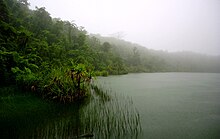
- Image 1Protected areas of Norway include:
About 17 percent of the mainland of Norway is protected. Of this, ca. 8.3 percent is national parks, 1.3 percent is nature reserves and 4.7 percent otherwise protected. (Full article...) - Image 2
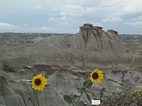
Dinosaur Provincial Park
This is a list of protected areas of Alberta. Protected areas are managed by the Government of Canada or the Government of Alberta. The provincial government owns 60% of Alberta's landmass but most of this has not been formally protected. The total protected area throughout Alberta including federal and provincial protected areas is approximately 90,700 km2 (35,000 sq mi). (Full article...) - Image 3
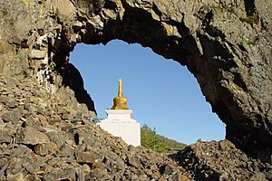
"Temple Gate" Rock formation at Alkhanay National Park
Protected areas of Russia, (official Russian title: Russian: Особо охраняемые природные территории, literally "Specially Protected Natural Areas"), is governed by the corresponding 1995 law of the Russian Federation. (Full article...) - Image 4

Ludaš Lake is a shallow lake in the province of Vojvodina in northern Serbia, near the city of Subotica. It is a special natural preserve and, since 1977, designated as a swamp area of international significance by the Ramsar Convention.
Protected areas cover around 5% of the territory of Serbia. The Law on the Protection of the Nature defines these categories of protected areas:- Strict nature reserve — Area of unmodified natural features with representative ecosystems set aside for the preservation of its biodiversity and for scientific research and monitoring.
- Special nature reserve — Area of unmodified or slightly modified natural features of great importance due to uniqueness and rarity which includes the habitats of endangered species set aside for the preservation of its unique features, education, limited tourism and for scientific research and monitoring.
- National park — Area with large number of diverse ecosystems of national value, with outstanding natural features and/or cultural heritage set aside for the preservation of its natural resources and for educational, scientific and tourist use.
- Natural monument — Small unmodified or slightly modified natural feature, object or phenomenon, easily detectable and unique, with unique natural attributes.
- Protected habitat — Area which includes habitats of one or more wildlife species.
- Landscape of outstanding features — Area of remarkable appearance with important natural and cultural value.
- Nature park — Area of well-preserved natural values with preserved natural ecosystems and picturesque landscape set aside for the preservation of biodiversity and for educational, tourist, recreational and scientific use.
- Image 5Protected areas of Tamil Nadu cover an area of 3,305 km2 (1,276 sq mi), constituting 2.54% of the geographic area and 15% of the 22,643 km2 (8,743 sq mi) recorded forest area of the state of Tamil Nadu in South India. It ranks 14th among all the states and union territories of India in terms of total protected area.
Protected areas in South India were created from private hunting grounds of the erstwhile Maharajas of the princely states. Mudumalai National Park was established in 1940 and was the first modern wildlife sanctuary in South India. The protected areas are administered by the Ministry of Environment and Forests of Government of India and the Tamil Nadu Forest Department. (Full article...) - Image 6This is a list of protected areas of Sierra Leone, including national parks, game reserves, conservation areas, wetlands, and those that are listed as proposed protected areas in the UN Environment Programme World Conservation Monitoring Centre (UNEP WCM) database. (Full article...)
- Image 7
Upolu Island, Samoa
This is a list of some protected areas of Samoa which include national parks, reservations, protected nature zones, marine reserves and other areas of significant biodiversity and conservation.
In 1994, Samoa ratified the international and legally binding treaty, the Convention on Biological Diversity to develop national strategies for conservation and sustainable use of biological diversity. In 2010, protected areas in the country cover 5% of land although the government aims to increase protected areas coverage to 15%. (Full article...) - Image 8Protected areas of Ukraine (Ukrainian: охоронні території) are special areas of Ukraine established with the goal of protecting the natural and cultural heritage of the country from excessive changes as a result of human activity. The protection of the areas is the responsibility of the government of Ukraine, specifically the Cabinet of Ministers of Ukraine.
Ukraine has several categories of protected areas of Ukraine and the protected areas include: (Full article...) - Image 9Protected areas of Tasmania consist of protected areas located within Tasmania and its immediate onshore waters, including Macquarie Island. It includes areas of crown land (withheld land) managed by Tasmanian Government agencies as well as private reserves. As of 2016, 52% of Tasmania's land area has some form of reservation classification, the majority is managed by the Tasmania Parks & Wildlife Service (about 42% of total Tasmanian land area). Marine protected areas cover about 7.9% of state waters.
Within each classification of reserve there may be a variation of IUCN categories Australia is a signatory to the Convention of Biological Diversity and as such has obligations to report the status of its National Reserve System.IUCN provides on its website a prescription for activities consistent with the categorisation system. Changes made to the Nature Conservation Act 2002 in 2014 permit timber harvesting. These changes made in addition to the already established right to access minerals means that many of the IUCN categorisations assigned to individual reserves in Tasmania are no longer fit for purpose. In addition many reserves have had their reserve status downgraded from a class excluding timber harvesting and mineral extraction to ones where these activities are now permitted. This mis-application of the IUCN protected area categories needs to be remedied or the reserves protected land class under the Nature Conservation Act 2002 should be adjusted to reflect its currently assigned IUCN category. (Full article...) - Image 10

Bonampak is an ancient Maya archaeological site in the Mexican state of Chiapas, and is a natural monument.
There are currently 225 Protected Natural Areas in Mexico, covering 93.8 million hectares in total. They are protected and administered by the National Commission of Protected Natural Areas (Comisión Nacional de Áreas Naturales Protegidas, or 'CONANP'), a federal agency. CONANP administers:- 77 Mexican National Parks
- 48 biosphere reserves
- 54 flora and fauna protection areas
- 28 Mexican Nature Sanctuaries
- 13 natural resources protection areas
- 5 natural monuments
- Image 11Protected areas of Libya include any geographical area protected for a specific use.
Most protected areas are intended for the conservation of flora and fauna. Libya's national parks and nature reserves are maintained by the "Technical Committee of Wildlife and National Parks" which was created in 1990, as part of the General Secretariat of Agricultural Reclamation and Land Reform. (Full article...) - Image 12
- Image 13This is a list of protected areas of Ontario that are administered by Government of Ontario. Ontario Parks and the Ministry of the Environment, Conservation and Parks are the provincial bodies responsible for managing these protected areas. (Full article...)
- Image 14
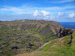
Rano Kau, Parque National Rapa Nui, Easter Island
The protected areas of Chile are areas that have natural beauty or significant historical value protected by the government of Chile. These protected areas cover over 140,000 km2 (54,054 sq mi), which is 19% of the territory of Chile. The National System of Protected Wild Areas (SNASPE by its Spanish acronym) is regulated by law #18,362 passed in 1984, and administered by the National Forest Corporation (CONAF).
There are three types of territories:- National Parks
- National Reserves
- Natural Monuments
- Image 15The main protected areas of Croatia are national parks, nature parks and strict reserves. There are 444 protected areas of Croatia, encompassing 9% of the country. Those include 8 national parks in Croatia, 2 strict reserves and 11 nature parks. The most famous protected area and the oldest national park in Croatia is the Plitvice Lakes National Park, a UNESCO World Heritage Site. Velebit Nature Park is a part of the UNESCO Man and the Biosphere Programme. The strict and special reserves, as well as the national and nature parks, are managed and protected by the central government, while other protected areas are managed by counties. In 2005, the National Ecological Network was set up, as the first step in preparation of the EU accession and joining of the Natura 2000 network.
The total area of all national parks in the country is 994 km2 (384 sq mi), of which 235 km2 (91 sq mi) is sea surface. Each of the national parks is maintained by a separate institution, overseen and funded by the government ministry of nature conservation and spatial development. The State Institute for Nature Protection provides centralized oversight and expertise. (Full article...)


Selected world maps
 Image 1A plate tectonics map with volcano locations indicated with red circles
 Image 2The Goode homolosine projection is a pseudocylindrical, equal-area, composite map projection used for world maps.
 Image 3Only a few of the largest large igneous provinces appear (coloured dark purple) on this geological map, which depicts crustal geologic provinces as seen in seismic refraction data
 Image 4Index map from the International Map of the World (1:1,000,000 scale)
 Image 5Mollweide projection of the world
 Image 6The world map by Gerardus Mercator (1569), the first map in the well-known Mercator projection
 Image 71516 map of the world by Martin Waldseemüller
 Image 8Time zones of the world
 Image 9United Nations Human Development Index map by country (2016)


World records
- List of Olympic records in athletics
- List of world records in athletics
- List of junior world records in athletics
- List of world records in masters athletics
- List of world youth bests in athletics
- List of IPC world records in athletics
- List of world records in canoeing
- List of world records in chess
- List of cycling records
- List of world records in track cycling
- List of world records in finswimming
- List of world records in juggling
- List of world records in rowing
- List of world records in speed skating
- List of world records in swimming
- List of IPC world records in swimming
- List of world records in Olympic weightlifting
Topics
Categories

Wikimedia
The following Wikimedia Foundation sister projects provide more on this subject:
-
 Commons
Free media repository -
 Wikibooks
Free textbooks and manuals -
 Wikidata
Free knowledge base -
 Wikinews
Free-content news -
 Wikiquote
Collection of quotations -
 Wikisource
Free-content library -
 Wikispecies
Directory of species -
 Wikiversity
Free learning tools -
 Wikivoyage
Free travel guide -
 Wiktionary
Dictionary and thesaurus


