Portal:Geography
Wikipedia portal for content related to Geography / From Wikipedia, the free encyclopedia
Portal maintenance status: (February 2020)
|
Other vital articles |
|---|
More featured biographies |
|---|
The Geography Portal

Geography (from Ancient Greek γεωγραφία geōgraphía; combining gê 'Earth' and gráphō 'write') is the study of the lands, features, inhabitants, and phenomena of Earth. Geography is an all-encompassing discipline that seeks an understanding of Earth and its human and natural complexities—not merely where objects are, but also how they have changed and come to be. While geography is specific to Earth, many concepts can be applied more broadly to other celestial bodies in the field of planetary science. Geography has been called "a bridge between natural science and social science disciplines."
Origins of many of the concepts in geography can be traced to Greek Eratosthenes of Cyrene, who may have coined the term "geographia" (c. 276 BC – c. 195/194 BC). The first recorded use of the word γεωγραφία was as the title of a book by Greek scholar Claudius Ptolemy (100 – 170 AD). This work created the so-called "Ptolemaic tradition" of geography, which included "Ptolemaic cartographic theory." However, the concepts of geography (such as cartography) date back to the earliest attempts to understand the world spatially, with the earliest example of an attempted world map dating to the 9th century BCE in ancient Babylon. The history of geography as a discipline spans cultures and millennia, being independently developed by multiple groups, and cross-pollinated by trade between these groups. The core concepts of geography consistent between all approaches are a focus on space, place, time, and scale.
Today, geography is an extremely broad discipline with multiple approaches and modalities. There have been multiple attempts to organize the discipline, including the four traditions of geography, and into branches. Techniques employed can generally be broken down into quantitative and qualitative approaches, with many studies taking mixed-methods approaches. Common techniques include cartography, remote sensing, interviews, and surveying. (Full article...)
 Featured article - load new batch
 Image 1
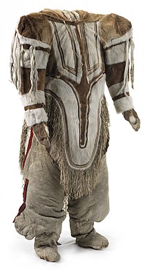
Women's traditional caribou skin outfit with amauti parka, trousers, mitts and long boots with side pouches. The back of the parka has an amaut or pouch for carrying a baby. From Baker Lake, Eskimo Point and Hikoligjuaq, west of Hudson Bay. Collected on 5th Thule Expedition, 1921–1924
Traditional Inuit clothing is a complex system of cold-weather garments historically made from animal hide and fur, worn by Inuit, a group of culturally related Indigenous peoples inhabiting the Arctic areas of Canada, Greenland, and the United States. The basic outfit consisted of a parka, pants, mittens, inner footwear, and outer boots. The most common sources of hide were caribou, seals, and seabirds, although other animals were used when available. The production of warm, durable clothing was an essential survival skill which was passed down from women to girls, and which could take years to master. Preparation of clothing was an intensive, weeks-long process that occurred on a yearly cycle following established hunting seasons. The creation and use of skin clothing was strongly intertwined with Inuit religious beliefs.
Despite the wide geographical distribution of Inuit across the Arctic, historically, these garments were consistent in both design and material due to the common need for protection against the extreme weather and the limited range of materials suitable for the purpose. The appearance of individual garments varied according to gender roles and seasonal needs, as well as the specific dress customs of each tribe or group. The Inuit decorated their clothing with fringes, pendants, and insets of contrasting colours, and later adopted techniques such as beadwork when trade made new materials available. (Full article...)- Image 2
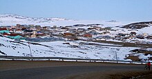
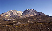 Nevados de Putre, Taapaca volcano (right)
Taapaca is a Holocene volcanic complex in northern Chile's Arica y Parinacota Region. Located in the Chilean Andes, it is part of the Central Volcanic Zone of the Andean Volcanic Belt, one of four distinct volcanic chains in South America. The town of Putre lies at the southwestern foot of the volcano.
Like other volcanoes of the Central Volcanic Zone, Taapaca formed from the subduction of the Nazca Plate beneath the South America Plate. It lies on the western margin of the Altiplano high plateau, on top of older volcanic and sedimentary units. Taapaca has mainly erupted dacite, in the form of numerous lava domes, although an andesitic stratovolcano is also present. (Full article...) - Image 3
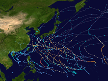
The 2002 Pacific typhoon season was a slightly above average Pacific typhoon season, producing twenty-six named storms, fifteen becoming typhoons, and eight super typhoons. It had an ACE over 400 units, making it one of the most active seasons worldwide. It was an event in the annual cycle of tropical cyclone formation, in which tropical cyclones form in the western Pacific Ocean. The season ran throughout 2002, though most tropical cyclones typically develop between May and October. The season's first named storm, Tapah, developed on January 11, while the season's last named storm, Pongsona, dissipated on December 11. The season's first typhoon, Mitag, reached typhoon status on March 1, and became the first super typhoon of the year four days later.
The scope of this article is limited to the Pacific Ocean, to the north of the equator between 100°E and the 180th meridian. Within the northwestern Pacific Ocean, there are two separate agencies that assign names to tropical cyclones, which can often result in a cyclone having two names, one from the JMA and one from PAGASA. The Japan Meteorological Agency (JMA) will name a tropical cyclone should it be judged to have 10-minute sustained wind speeds of at least 65 km/h (40 mph) anywhere in the basin, while the Philippine Atmospheric, Geophysical and Astronomical Services Administration (PAGASA) assigns names to tropical cyclones which move into or form as a tropical depression in their area of responsibility located between 135°E and 115°E and between 5°N–25°N regardless of whether or not a tropical cyclone has already been given a name by the JMA. Tropical depressions that are monitored by the United States' Joint Typhoon Warning Center (JTWC) are given a number with a "W" suffix. (Full article...) - Image 4
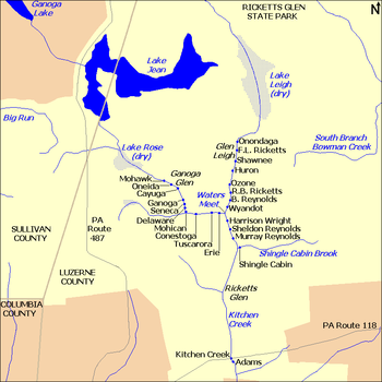
There are 24 named waterfalls in Ricketts Glen State Park in the U.S. state of Pennsylvania along Kitchen Creek as it flows in three steep, narrow valleys, or glens. They range in height from 9 feet (2.7 m) to the 94-foot (29 m) Ganoga Falls. Ricketts Glen State Park is named for R. Bruce Ricketts, a colonel in the American Civil War who owned over 80,000 acres (32,000 hectares) in the area in the late 19th and early 20th centuries, but spared the old-growth forests in the glens from clearcutting. The park, which opened in 1944, is administered by the Bureau of State Parks of the Pennsylvania Department of Conservation and Natural Resources (DCNR). Nearly all of the waterfalls are visible from the Falls Trail, which Ricketts had built from 1889 to 1893 and which the state park rebuilt in the 1940s and late 1990s. The Falls Trail has been called "the most magnificent hike in the state" and one of "the top hikes in the East". (Full article...) - Image 5
Michael was born near Apex, Iqaluit.
Simonie Michael (Inuktitut: ᓴᐃᒨᓂ ᒪᐃᑯᓪ; first name also spelled Simonee, alternative surnames Michel or E7-551; March 2, 1933 – November 15, 2008) was a Canadian politician from the eastern Northwest Territories (now Nunavut) who was the first Inuk elected to a legislature in Canada. Before becoming involved in politics, Michael worked as a carpenter and business owner, and was one of very few translators between Inuktitut and English. He became a prominent member of the Inuit co-operative housing movement and a community activist in Iqaluit, and was appointed to a series of governing bodies, including the precursor to the Iqaluit City Council.
After becoming the first elected Inuk member of the Northwest Territories Legislative Council, in 1966, Michael worked on infrastructural and public health initiatives. He is credited with bringing public attention to the dehumanizing effects of the disc number system that was used in place of surnames for Inuit, and with prompting the government to authorise Project Surname to replace the numbers with names. (Full article...) - Image 6
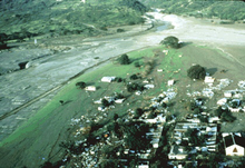 Lahars covering the town of Armero
The Armero tragedy (Spanish: Tragedia de Armero [tɾaˈxeðja ðe aɾˈmeɾo]) occurred following the eruption of the Nevado del Ruiz stratovolcano in Tolima, Colombia, on November 13, 1985. The volcano's eruption after 69 years of dormancy caught nearby towns unprepared, even though volcanological organizations had warned the government to evacuate the area after they detected volcanic activity two months earlier.
As pyroclastic flows erupted from the volcano's crater, they melted the mountain's glaciers, sending four enormous lahars (volcanically induced mudflows, landslides, and debris flows) down its slopes at 50 km/h (30 mph). The lahars picked up speed in gullies and engulfed the town of Armero, killing more than 20,000 of its almost 29,000 inhabitants. Casualties in other towns, particularly Chinchiná, brought the overall death toll to 23,000. Footage and photographs of Omayra Sánchez, a young victim of the disaster, were published around the world. Other photographs of the lahars and the impact of the disaster captured attention worldwide and led to controversy over the degree to which the Colombian government was responsible for the disaster. A banner at a mass funeral in Ibagué read, "The volcano didn't kill 22,000 people. The government killed them." (Full article...) - Image 7

The Maya civilization (/ˈmaɪə/) was a Mesoamerican civilization that existed from antiquity to the early modern period. It is known by its ancient temples and glyphs (script). The Maya script is the most sophisticated and highly developed writing system in the pre-Columbian Americas. The civilization is also noted for its art, architecture, mathematics, calendar, and astronomical system.
The Maya civilization developed in the Maya Region, an area that today comprises southeastern Mexico, all of Guatemala and Belize, and the western portions of Honduras and El Salvador. It includes the northern lowlands of the Yucatán Peninsula and the Guatemalan Highlands of the Sierra Madre, the Mexican state of Chiapas, southern Guatemala, El Salvador, and the southern lowlands of the Pacific littoral plain. Today, their descendants, known collectively as the Maya, number well over 6 million individuals, speak more than twenty-eight surviving Mayan languages, and reside in nearly the same area as their ancestors. (Full article...) - Image 8
 Rogue River from Hellgate Canyon
The Rogue River (Tolowa: yan-shuu-chit’ taa-ghii~-li~’, Takelma: tak-elam) in southwestern Oregon in the United States flows about 215 miles (346 km) in a generally westward direction from the Cascade Range to the Pacific Ocean. Known for its salmon runs, whitewater rafting, and rugged scenery, it was one of the original eight rivers named in the Wild and Scenic Rivers Act of 1968. Beginning near Crater Lake, which occupies the caldera left by the explosive volcanic eruption and collapse of Mount Mazama, the river flows through the geologically young High Cascades and the older Western Cascades, another volcanic province. Further west, the river passes through multiple exotic terranes of the more ancient Klamath Mountains. In the Kalmiopsis Wilderness section of the Rogue basin are some of the world's best examples of rocks that form the Earth's mantle. Near the mouth of the river, the only dinosaur fragments ever discovered in Oregon were found in the Otter Point Formation, along the coast of Curry County.
People have lived along the Rogue River and its tributaries for at least 8,500 years. European explorers made first contact with Native Americans (Indians) toward the end of the 18th century and began beaver trapping and other activities in the region. Clashes, sometimes deadly, occurred between the natives and the trappers and later between the natives and European-American miners and settlers. These struggles culminated with the Rogue River Wars of 1855–56 and removal of most of the natives to reservations outside the basin. After the war, settlers expanded into remote areas of the watershed and established small farms along the river between Grave Creek and the mouth of the Illinois River. They were relatively isolated from the outside world until 1895, when the Post Office Department added mail boat service along the lower Rogue. As of 2010, the Rogue has one of the two remaining rural mail-boat routes in the United States. (Full article...) - Image 9
 Glicken at work, 1980s
Harry Glicken (March 7, 1958 – June 3, 1991) was an American volcanologist. He researched Mount St. Helens in the United States before and after its 1980 eruption, and was very distraught about the death of volcanologist David A. Johnston, who was Glicken's mentor and supervisor in Spring 1980 at Mount St. Helens. Glicken was initially assigned to the USGS observation post in the weeks leading up to the eruption but was called away the night before the eruption.
In 1991, while conducting avalanche research on Mount Unzen in Japan, Glicken and fellow volcanologists Katia and Maurice Krafft were killed by a pyroclastic flow. His remains were found four days later and were cremated in accordance with his parents' request. Glicken and Johnston remain the only American volcanologists known to have died in volcanic eruptions. (Full article...) - Image 10
 False colour image of Laguna del Maule
Laguna del Maule is a volcanic field in the Andes mountain range of Chile, close to, and partly overlapping, the Argentina–Chile border. The bulk of the volcanic field is in the Talca Province of Chile's Maule Region. It is a segment of the Southern Volcanic Zone, part of the Andean Volcanic Belt. The volcanic field covers an area of 500 km2 (190 sq mi) and features at least 130 volcanic vents. Volcanic activity has generated cones, lava domes, lava coulees and lava flows, which surround the Laguna del Maule lake. The field gets its name from the lake, which is also the source of the Maule River.
The field's volcanic activity began 1.5 million years ago during the Pleistocene epoch; such activity has continued into the postglacial and Holocene epoch after glaciers retreated from the area. Postglacial volcanic activity has included eruptions with simultaneous explosive and effusive components, as well as eruptions with only one component. In the postglacial era, volcanic activity has increased at Laguna del Maule, with the volcanic field rapidly inflating during the Holocene. Three major caldera-forming eruptions took place in the volcanic field prior to the last glacial period. The most recent eruptions in the volcanic field took place 2,500 ± 700, 1,400 ± 600 and 800 ± 600 years ago and generated lava flows; today geothermal phenomena occur at Laguna del Maule. Volcanic rocks in the field include basalt, andesite, dacite and rhyolite; the latter along with rhyodacite makes up most of the Holocene rocks. In pre-Columbian times, the field was a regionally important source of obsidian. (Full article...) - Image 11
 An aerial view over Manchester city centre (top) and Trafford Park (bottom) south of the Manchester Ship Canal.
Trafford Park is an area of the Metropolitan Borough of Trafford, Greater Manchester, England, opposite Salford Quays on the southern side of the Manchester Ship Canal, 3.4 miles (5.5 km) southwest of Manchester city centre and 1.3 miles (2.1 km) north of Stretford. Until the late 19th century, it was the ancestral home of the Trafford family, who sold it to financier Ernest Terah Hooley in 1896. Occupying an area of 4.7 square miles (12 km2), it was the first planned industrial estate in the world, and remains the largest in Europe well over a century later.
Trafford Park is almost entirely surrounded by water; the Bridgewater Canal forms its southeastern and southwestern boundaries, and the Manchester Ship Canal, which opened in 1894, its northeastern and northwestern. Hooley's plan was to develop the Ship Canal frontage, but the canal was slow to generate the predicted volume of traffic, so in the early days the park was largely used for leisure activities such as golf, polo and boating. (Full article...) - Image 12

Kent is a city in the U.S. state of Ohio and the largest city in Portage County. It is located along the Cuyahoga River in Northeast Ohio on the western edge of the county. The population was 28,215 at the 2020 Census. The city is counted as part of the Akron metropolitan area and the larger Cleveland–Akron–Canton combined statistical area.
Part of the Connecticut Western Reserve, Kent was settled in 1805 and was known for many years as Franklin Mills. Settlers were attracted to the area due to its location along the Cuyahoga River as a place for water-powered mills. Later development came in the 1830s and 1840s as a result of the settlement's position along the route of the Pennsylvania and Ohio Canal. Leading up to the American Civil War, Franklin Mills was noted for its activity in the Underground Railroad. With the decline of the canal and the emergence of the railroad, the town became the home of the Atlantic and Great Western Railroad maintenance shops through the influence of Marvin Kent. In 1864 the town was renamed Kent in honor of and in gratitude for Marvin Kent's efforts. It was incorporated as a village in 1867 and became a city after the 1920 Census. Today Kent is a college town best known as the home of the main campus of Kent State University, founded in 1910, and as the site of the May 4, 1970 Kent State shootings. (Full article...) - Image 13

Edward Adrian Wilson, Robert Falcon Scott, Lawrence Oates, Henry Robertson Bowers and Edgar Evans at the South Pole
The Terra Nova Expedition, officially the British Antarctic Expedition, was an expedition to Antarctica which took place between 1910 and 1913. Led by Captain Robert Falcon Scott, the expedition had various scientific and geographical objectives. Scott wished to continue the scientific work that he had begun when leading the Discovery Expedition from 1901 to 1904, and wanted to be the first to reach the geographic South Pole.
He and four companions attained the pole on 17 January 1912, where they found that a Norwegian team led by Roald Amundsen had preceded them by 34 days. Scott's party of five died on the return journey from the pole; some of their bodies, journals, and photographs were found by a search party eight months later.
The expedition, named after its supply ship, was a private venture financed by public contributions and a government grant. It had further backing from the Admiralty, which released experienced seamen to the expedition, and from the Royal Geographical Society. The expedition's team of scientists carried out a comprehensive scientific programme, while other parties explored Victoria Land and the Western Mountains. An attempted landing and exploration of King Edward VII Land was unsuccessful. A journey to Cape Crozier in June and July 1911 was the first extended sledging journey in the depths of the Antarctic winter. (Full article...) - Image 14

Bulgaria, officially the Republic of Bulgaria, is a country in Southeast Europe. Located west of the Black Sea and south of the Danube river, Bulgaria is bordered by Greece and Turkey to the south, Serbia and North Macedonia to the west, and Romania to the north. It covers a territory of 110,994 square kilometres (42,855 sq mi) and is the 16th largest country in Europe. Sofia is the nation's capital and largest city; other major cities include Burgas, Plovdiv, and Varna.
One of the earliest societies in the lands of modern-day Bulgaria was the Karanovo culture (6,500 BC). In the 6th to 3rd century BC, the region was a battleground for ancient Thracians, Persians, Celts and Macedonians; stability came when the Roman Empire conquered the region in AD 45. After the Roman state splintered, tribal invasions in the region resumed. Around the 6th century, these territories were settled by the early Slavs. The Bulgars, led by Asparuh, attacked from the lands of Old Great Bulgaria and permanently invaded the Balkans in the late 7th century. They established the First Bulgarian Empire, victoriously recognised by treaty in 681 AD by the Byzantine Empire. It dominated most of the Balkans and significantly influenced Slavic cultures by developing the Cyrillic script. The First Bulgarian Empire lasted until the early 11th century, when Byzantine emperor Basil II conquered and dismantled it. A successful Bulgarian revolt in 1185 established a Second Bulgarian Empire, which reached its apex under Ivan Asen II (1218–1241). After numerous exhausting wars and feudal strife, the empire disintegrated and in 1396 fell under Ottoman rule for nearly five centuries. (Full article...) - Image 15

The ACFEL ice auger showing an ice core pushed up into the core remover barrel.
Ice drilling allows scientists studying glaciers and ice sheets to gain access to what is beneath the ice, to take measurements along the interior of the ice, and to retrieve samples. Instruments can be placed in the drilled holes to record temperature, pressure, speed, direction of movement, and for other scientific research, such as neutrino detection.
Many different methods have been used since 1840, when the first scientific ice drilling expedition attempted to drill through the Unteraargletscher in the Alps. Two early methods were percussion, in which the ice is fractured and pulverized, and rotary drilling, a method often used in mineral exploration for rock drilling. In the 1940s, thermal drills began to be used; these drills melt the ice by heating the drill. Drills that use jets of hot water or steam to bore through ice soon followed. A growing interest in ice cores, used for palaeoclimatological research, led to ice coring drills being developed in the 1950s and 1960s, and there are now many different coring drills in use. For obtaining ice cores from deep holes, most investigators use cable-suspended electromechanical drills, which use an armoured cable to carry electrical power to a mechanical drill at the bottom of the borehole. (Full article...)

.jpg)


.jpg)


 Vital article
.svg)
Related portals
Get involved
 |
Here are some tasks awaiting attention:
|
Selected pictures
 Image 1Map: Strebe, using GeocartThe Peirce quincuncial projection is a conformal map projection developed by Charles Sanders Peirce in 1879, while he was working at the U.S. Coast and Geodetic Survey. In the normal aspect Peirce's projection presents the Northern Hemisphere in a square; the Southern Hemisphere is split into four 90°–45°–45° triangles surrounding it so that the whole map forms a larger square.
 Image 2Photo credit: Joaquim Alves GasparIllustration of the Ptolemaic geocentric model of the Universe (the theory that the Earth is the center of the universe) by Portuguese cosmographer and cartographer Bartolomeu Velho. Taken from his treatise Cosmographia, made in Paris, 1568. Notice the distances of the bodies to the centre of the Earth (left) and the times of revolution, in years (right).
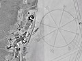 Image 3Photo credit: NASAThe world's largest compass rose, drawn on the desert floor at Edwards Air Force Base in California, United States. Painted on the dry lake near Dryden Flight Research Center, it is inclined to magnetic north and is used by pilots for calibrating heading indicators.
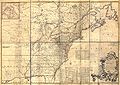 Image 4Author: John Mitchell; scan: Library of Congress, Geography and Map Division.The Mitchell Map is the most comprehensive map of eastern North America made during the colonial era. Measuring about 6.5 ft (2.0 m) wide by 4.5 ft (1.4 m) high, it was produced by John Mitchell in 1757 in eight separate sheets. The map was used during the Treaty of Paris for defining the boundaries of the United States, and remains important today for resolving border disputes.
 Image 5The geography of Australia, the world's smallest continent, encompasses a wide variety of biogeographic regions. By surface area, it is the sixth-largest country in the world, but as can be seen in this composite satellite image, much of the interior is arid desert. The vast majority of the human population is concentrated along the eastern and southeastern coasts, and it is the fiftieth most populous nation.
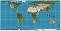 Image 6Map: Strebe, using GeocartThe Hobo–Dyer projection is a cylindrical equal-area projection commissioned in 2002 by Bob Abramms and Howard Bronstein. This projection was drafted by cartographer Mick Dyer, who based it on the 1910 Behrmann projection.
 Image 7A map of the Olmec heartland, the southern portion of Mexico's Gulf Coast region between the Tuxtla mountains and the Olmec archaeological site of La Venta. It is considered the heartland of the Olmec culture, which was widespread over Mesoamerica from 1400 BCE until roughly 400 BCE.
On this map, yellow dots represent ancient habitation sites, including San Lorenzo Tenochtitlán, La Venta, and Tres Zapotes. Red dots represent isolated artifact finds unassociated with any ancient town or village, such as the Las Limas Monument 1, the San Martín Pajapan Monument 1, and "The Wrestler". Image 8Map: Strebe, using GeocartThe Gall–Peters projection, named after James Gall and Arno Peters, is a specialization of a configurable equal-area map projection known as the cylindrical equal-area projection. It achieved considerable notoriety in the late 20th century as the centerpiece of a controversy surrounding the political implications of map design; Peters promoted it as a more faithful representation than the Mercator projection, which inflates the sizes of regions farther from the equator and thus makes the (mostly technologically underdeveloped) equatorial countries appear smaller and therefore, according to Peters, less significant.
 Image 9A world map entitled Nova totius terrarum orbis tabula Amstelodami, created in 1689 by Gerard van Schagen. This map, created in Amsterdam, measures 48.3 by 56.0 centimetres (19.0 by 22.0 in) in size and was made using copper engraving.
 Image 10Map: Strebe, using GeocartThe Craig retroazimuthal is a modified cylindrical map projection created by James Ireland Craig in 1909. It preserves the direction from any place to one other, predetermined place while avoiding some of the distortion of the Hammer retroazimuthal projection. This projection is sometimes known as the Mecca projection because Craig, who had worked in Egypt as a cartographer, created it to help Muslims find the qibla.
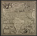 Image 11Map: Diego Gutiérrez and Hieronymus CockAmericae Sive Quartae Orbis Partis Nova Et Exactissima Descriptio is an ornate geographical map of the Americas made in 1562 by Spanish cartographer Diego Gutiérrez and Flemish artist Hieronymus Cock. The map encompasses the eastern coast of North America, the whole of Central and South America, and parts of the western coasts of Europe and Africa. This is the earliest scale wall map of the New World and the first to use the name "California". Two extant copies are known.
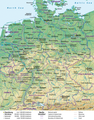 Image 12Map credit: Lencer and NordNordWestA general map, showing the geography of Germany, the seventh largest country in Europe and the second most populous. Located in Central Europe, Germany is second only to Russia in the number of borders it shares with other European countries (9).
 Image 13Map: Strebe, using GeocartThe Albers projection is a conic, equal area map projection, named after Heinrich C. Albers, that uses two standard parallels. Although scale and shape are not preserved, distortion is minimal between the standard parallels. This map is used by such agencies as the United States Geological Survey, the United States Census Bureau, and the governments of British Columbia and Yukon.
 Image 14Map: Strebe, using GeocartThe Lambert conformal conic projection is a conic map projection used for aeronautical charts, portions of the State Plane Coordinate System, and many national and regional mapping systems. It is one of seven projections introduced by Johann Heinrich Lambert in 1772. Conceptually, the projection seats a cone over the sphere of the Earth and projects the surface conformally onto the cone. The cone is unrolled, and the parallel that was touching the sphere is assigned unit scale. By scaling the resulting map, two parallels can be assigned unit scale, with scale decreasing between them and increasing outside them. Unlike other conic projections, no true secant form of this projection exists.
 Image 15Map credit: Robert WilkinsonAn 18th century map of the Iberian Peninsula illustrating various topographic features of the land. The Iberian Peninsula, or Iberia, is located in the extreme southwest of Europe, and includes modern day Spain, Portugal, Gibraltar and Andorra.


Featured biography

Caspar David Friedrich (5 September 1774 – 7 May 1840) was a German Romantic landscape painter, generally considered the most important German artist of his generation. He is best known for his allegorical landscapes, which typically feature contemplative figures silhouetted against night skies, morning mists, barren trees or Gothic ruins. His primary interest was the contemplation of nature, and his often symbolic and anti-classical work seeks to convey a subjective, emotional response to the natural world. Friedrich's paintings characteristically set a human presence in diminished perspective amid expansive landscapes, reducing the figures to a scale that, according to the art historian Christopher John Murray, directs "the viewer's gaze towards their metaphysical dimension".
Friedrich was born in the town of Greifswald on the Baltic Sea in what was at the time Swedish Pomerania. He studied in Copenhagen until 1798, before settling in Dresden. He came of age during a period when, across Europe, a growing disillusionment with materialistic society was giving rise to a new appreciation of spirituality. This shift in ideals was often expressed through a reevaluation of the natural world, as artists such as Friedrich, J. M. W. Turner and John Constable sought to depict nature as a "divine creation, to be set against the artifice of human civilization". (Full article...)Did you know
- ... that glaciation in Wisconsin 17 thousand years ago helped create its unique geography?
- ... that Johann Reinhold Forster's 1778 book Observations Made During a Voyage Round the World has been described as "the beginning of modern geography"?
Places around you
Top 10 WikiProject Geography Popular articles of the month
- Image 1Generation Z (often shortened to Gen Z), also known as Zoomers, is the demographic cohort succeeding Millennials and preceding Generation Alpha. Researchers and popular media generally use the late 1990s as starting birth years and the early 2010s as ending birth years to define the cohort. Most members of Generation Z are the children of younger Baby Boomers or Generation X. (Full article...)
- Image 2

A map of the United States showing its 50 states, federal district and five inhabited territories. Alaska, Hawaii, and the territories are shown at different scales, and the Aleutian Islands and the uninhabited northwestern Hawaiian Islands are omitted from the map.
The United States of America is a federal republic consisting of 50 states, a federal district (Washington, D.C., the capital city of the United States), five major territories, and various minor islands. Both the states and the United States as a whole are each sovereign jurisdictions. The Tenth Amendment to the United States Constitution allows states to exercise all powers of government not delegated to the federal government. Each state has its own constitution and government, and all states and their residents are represented in the federal Congress, a bicameral legislature consisting of the Senate and the House of Representatives. Each state is represented by two senators, while representatives are distributed among the states in proportion to the most recent constitutionally mandated decennial census. Additionally, each state is entitled to select a number of electors to vote in the Electoral College, the body that elects the president of the United States, equal to the total of representatives and senators in Congress from that state. The federal district does not have representatives in the Senate, but has a non-voting delegate in the House, and it is also entitled to electors in the Electoral College. Congress can admit more states, but it cannot create a new state from territory of an existing state or merge two or more states into one without the consent of all states involved, and each new state is admitted on an equal footing with the existing states. (Full article...) - Image 3
 The Blue Marble, Apollo 17, December 1972
Earth is the third planet from the Sun and the only astronomical object known to harbor life. This is enabled by Earth being an ocean world, the only one in the Solar System sustaining liquid surface water. Almost all of Earth's water is contained in its global ocean, covering 70.8% of Earth's crust. The remaining 29.2% of Earth's crust is land, most of which is located in the form of continental landmasses within Earth's land hemisphere. Most of Earth's land is somewhat humid and covered by vegetation, while large sheets of ice at Earth's polar deserts retain more water than Earth's groundwater, lakes, rivers and atmospheric water combined. Earth's crust consists of slowly moving tectonic plates, which interact to produce mountain ranges, volcanoes, and earthquakes. Earth has a liquid outer core that generates a magnetosphere capable of deflecting most of the destructive solar winds and cosmic radiation. (Full article...) - Image 4Generation X (often shortened to Gen X) is the demographic cohort following the Baby Boomers and preceding Millennials. Researchers and popular media often use the mid-1960s as its starting birth years and the late 1970s as its ending birth years, with the generation being generally defined as people born from 1965 to 1980. By this definition and U.S. Census data, there are 65.2 million Gen Xers in the United States as of 2019. Most of Generation X are the children of the Silent Generation and early Baby Boomers; Xers are also often the parents of Millennials and Generation Z. (Full article...)
- Image 5

England is a country that is part of the United Kingdom. It is located on the island of Great Britain, of which it covers approximately 62%, and over 100 smaller adjacent islands. It has land borders with Scotland to the north and Wales to the west, and is otherwise surrounded by the North Sea to the east, the English Channel to the south, the Celtic Sea to the south-west, and the Irish Sea to the west. Continental Europe lies to the south-east, and Ireland to the west. At the 2021 census, the population was 56,490,048. London is both the largest city and the capital. (Full article...) - Image 6
 River Thames and Tower Bridge with The Shard and Southwark (left), and Tower of London and City of London (right)
London (/ˈlʌndən/ LUN-dən) is the capital and largest city of both England and the United Kingdom, with a population of 8,866,180 in 2022. The wider metropolitan area is the largest in Western Europe, with a population of 14.9 million. London stands on the River Thames in southeast England, at the head of a 50-mile (80 km) estuary down to the North Sea, and has been a major settlement for nearly 2,000 years. Its ancient core and financial centre, the City of London, was founded by the Romans as Londinium and has retained its medieval boundaries. The City of Westminster, to the west of the City of London, has been the centuries-long host of the national government and parliament. London grew rapidly in the 19th century, becoming the world's largest city at the time. Since the 19th century, the name "London" has referred to the metropolis around the City of London, historically split between the counties of Middlesex, Essex, Surrey, Kent, and Hertfordshire, which since 1965 has largely comprised the administrative area of Greater London, governed by 33 local authorities and the Greater London Authority. (Full article...) - Image 7

Cartogram of the world's population in 2018; each square represents 500,000 people.[needs update?]
This is a list of countries and dependencies by population. It includes sovereign states, inhabited dependent territories and, in some cases, constituent countries of sovereign states, with inclusion within the list being primarily based on the ISO standard ISO 3166-1. For instance, the United Kingdom is considered a single entity, while the constituent countries of the Kingdom of the Netherlands are considered separately. In addition, this list includes certain states with limited recognition not found in ISO 3166-1. Also given in a percentage is each country's population compared with the world population, which the United Nations estimates at 8.12 billion as of 2024. (Full article...) - Image 8Europe is a continent located entirely in the Northern Hemisphere and mostly in the Eastern Hemisphere. It is bordered by the Arctic Ocean to the north, the Atlantic Ocean to the west, the Mediterranean Sea to the south, and Asia to the east. Europe shares the landmass of Eurasia with Asia, and of Afro-Eurasia with both Asia and Africa. Europe is commonly considered to be separated from Asia by the watershed of the Ural Mountains, the Ural River, the Caspian Sea, the Greater Caucasus, the Black Sea, and the waterway of the Bosporus Strait. (Full article...)
- Image 9Millennials, also known as Generation Y or Gen Y, are the demographic cohort following Generation X and preceding Generation Z. Researchers and popular media use the early 1980s as starting birth years and the mid-1990s to early 2000s as ending birth years, with the generation typically being defined as people born from 1981 to 1996. Most Millennials are the children of Baby Boomers and older Generation X. In turn Millennials are often the parents of Generation Alpha. (Full article...)
- Image 10

Hong Kong is a special administrative region of the People's Republic of China. With 7.4 million residents of various nationalities in a 1,104-square-kilometre (426 sq mi) territory, Hong Kong is one of the most densely populated territories in the world. (Full article...)

.jpg)

.jpeg)


Featured pictures


Main articles
 Categories
Associated Wikimedia
The following Wikimedia Foundation sister projects provide more on this subject:
-
 Commons
Free media repository -
 Wikibooks
Free textbooks and manuals -
 Wikidata
Free knowledge base -
 Wikinews
Free-content news -
 Wikiquote
Collection of quotations -
 Wikisource
Free-content library -
 Wikiversity
Free learning tools -
 Wikivoyage
Free travel guide -
 Wiktionary
Dictionary and thesaurus


