Portal:Geology
Wikipedia portal for content related to Geology / From Wikipedia, the free encyclopedia
Portal maintenance status: (No date set)
|
Other vital articles |
|---|
More featured biographies |
|---|
The Geology Portal

Geology (from Ancient Greek γῆ (gê) 'earth', and λoγία (-logía) 'study of, discourse') is a branch of natural science concerned with the Earth and other astronomical objects, the rocks of which they are composed, and the processes by which they change over time. Modern geology significantly overlaps all other Earth sciences, including hydrology. It is integrated with Earth system science and planetary science.
Geology describes the structure of the Earth on and beneath its surface and the processes that have shaped that structure. Geologists study the mineralogical composition of rocks in order to get insight into their history of formation. Geology determines the relative ages of rocks found at a given location; geochemistry (a branch of geology) determines their absolute ages. By combining various petrological, crystallographic, and paleontological tools, geologists are able to chronicle the geological history of the Earth as a whole. One aspect is to demonstrate the age of the Earth. Geology provides evidence for plate tectonics, the evolutionary history of life, and the Earth's past climates.
Geologists broadly study the properties and processes of Earth and other terrestrial planets. Geologists use a wide variety of methods to understand the Earth's structure and evolution, including fieldwork, rock description, geophysical techniques, chemical analysis, physical experiments, and numerical modelling. In practical terms, geology is important for mineral and hydrocarbon exploration and exploitation, evaluating water resources, understanding natural hazards, remediating environmental problems, and providing insights into past climate change. Geology is a major academic discipline, and it is central to geological engineering and plays an important role in geotechnical engineering. (Full article...)
Recognized content - load new batch
 Image 1
 The Blue Marble, Apollo 17, December 1972
Earth is the third planet from the Sun and the only astronomical object known to harbor life. This is enabled by Earth being an ocean world, the only one in the Solar System sustaining liquid surface water. Almost all of Earth's water is contained in its global ocean, covering 70.8% of Earth's crust. The remaining 29.2% of Earth's crust is land, most of which is located in the form of continental landmasses within Earth's land hemisphere. Most of Earth's land is somewhat humid and covered by vegetation, while large sheets of ice at Earth's polar deserts retain more water than Earth's groundwater, lakes, rivers and atmospheric water combined. Earth's crust consists of slowly moving tectonic plates, which interact to produce mountain ranges, volcanoes, and earthquakes. Earth has a liquid outer core that generates a magnetosphere capable of deflecting most of the destructive solar winds and cosmic radiation.
Earth has a dynamic atmosphere, which sustains Earth's surface conditions and protects it from most meteoroids and UV-light at entry. It has a composition of primarily nitrogen and oxygen. Water vapor is widely present in the atmosphere, forming clouds that cover most of the planet. The water vapor acts as a greenhouse gas and, together with other greenhouse gases in the atmosphere, particularly carbon dioxide (CO2), creates the conditions for both liquid surface water and water vapor to persist via the capturing of energy from the Sun's light. This process maintains the current average surface temperature of 14.76 °C (58.57 °F), at which water is liquid under normal atmospheric pressure. Differences in the amount of captured energy between geographic regions (as with the equatorial region receiving more sunlight than the polar regions) drive atmospheric and ocean currents, producing a global climate system with different climate regions, and a range of weather phenomena such as precipitation, allowing components such as nitrogen to cycle. (Full article...)- Image 2

The 1867 Manhattan earthquake struck Riley County, Kansas, in the United States on April 24, 1867, at 20:22 UTC, or about 14:30 local time. The strongest earthquake to originate in the state, it measured 5.1 on a seismic scale that is based on an isoseismal map or the event's felt area. The earthquake's epicenter was near the town of Manhattan.
The earthquake had a maximum perceived intensity of VII (Very strong) on the Mercalli intensity scale. It caused minor damage, reports of which were confined to Kansas, Iowa, and Missouri, according to the United States Geological Survey. Felt over an area of 200,000 square miles (520,000 km2), the earthquake reached the states of Indiana, Illinois, and possibly Ohio, though the latter reports have been questioned. (Full article...) - Image 3
An earthquake struck Western Greece near the coastal city of Aigio at 03:15:48 local time on 15 June 1995. The second destructive earthquake to strike Greece in a month, it measured 6.4–6.5 on the moment magnitude scale (Mw ). It was assigned a maximum Modified Mercalli intensity of VIII (Severe) and EMS-98 intensity of IX (Destructive). The horizontal peak ground acceleration reached 0.54 g and ground velocity peaked at 52 cm/s (20 in/s)—the strongest ground motion ever recorded in Greece. Fifteen minutes after the mainshock, a large aftershock struck, causing further damage to Aigio. Faulting occurred on either the Aigion fault or an unnamed offshore fault. Other faults in the region have the potential to produce earthquakes up to Mw 6.9, which poses a risk to Aigio and the surrounding Gulf of Corinth.
Monetary damages from the earthquake reached $660 million (in 1995 USD). Significant destruction occurred; the collapse of two buildings left 26 dead and up to 200 injured. In the aftermath, several countries and organizations provided disaster aid, including search and rescue and refugee assistance operations. Many countries also donated medical supplies, temporary shelter, water treatment equipment, and a ship to house survivors. The Greek government issued seismic loans to aid in the rebuilding of Aigio, though it may have encouraged the construction of taller buildings—increasing Aigio's future seismic hazard. Controversy arose over the lack of a warning for the earthquake, as several sources warned officials that a major earthquake would occur. (Full article...) - Image 4
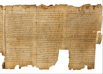
Radiocarbon dating helped verify the authenticity of the Dead Sea scrolls.
Radiocarbon dating (also referred to as carbon dating or carbon-14 dating) is a method for determining the age of an object containing organic material by using the properties of radiocarbon, a radioactive isotope of carbon.
The method was developed in the late 1940s at the University of Chicago by Willard Libby. It is based on the fact that radiocarbon (14
C) is constantly being created in the Earth's atmosphere by the interaction of cosmic rays with atmospheric nitrogen. The resulting 14
C combines with atmospheric oxygen to form radioactive carbon dioxide, which is incorporated into plants by photosynthesis; animals then acquire 14
C by eating the plants. When the animal or plant dies, it stops exchanging carbon with its environment, and thereafter the amount of 14
C it contains begins to decrease as the 14
C undergoes radioactive decay. Measuring the proportion of 14
C in a sample from a dead plant or animal, such as a piece of wood or a fragment of bone, provides information that can be used to calculate when the animal or plant died. The older a sample is, the less 14
C there is to be detected, and because the half-life of 14
C (the period of time after which half of a given sample will have decayed) is about 5,730 years, the oldest dates that can be reliably measured by this process date to approximately 50,000 years ago (in this interval about 99.8% of the 14
C will have decayed), although special preparation methods occasionally make an accurate analysis of older samples possible. In 1960, Libby received the Nobel Prize in Chemistry for his work. (Full article...) - Image 5

Life in the Ediacaran Period as imagined by researchers in 1980.
The Ediacaran (/ˌiːdiˈækərən/; formerly Vendian) biota is a taxonomic period classification that consists of all life forms that were present on Earth during the Ediacaran Period (c. 635–538.8 Mya). These were enigmatic tubular and frond-shaped, mostly sessile, organisms. Trace fossils of these organisms have been found worldwide, and represent the earliest known complex multicellular organisms. The term "Ediacara biota" has received criticism from some scientists due to its alleged inconsistency, arbitrary exclusion of certain fossils, and inability to be precisely defined.
The Ediacaran biota may have undergone evolutionary radiation in a proposed event called the Avalon explosion, 575 million years ago. This was after the Earth had thawed from the Cryogenian period's extensive glaciation. This biota largely disappeared with the rapid increase in biodiversity known as the Cambrian explosion. Most of the currently existing body plans of animals first appeared in the fossil record of the Cambrian rather than the Ediacaran. For macroorganisms, the Cambrian biota appears to have almost completely replaced the organisms that dominated the Ediacaran fossil record, although relationships are still a matter of debate. (Full article...) - Image 6
 Photograph of the eruption column, May 18, 1980, taken by Austin Post
On March 27, 1980, a series of volcanic explosions and pyroclastic flows began at Mount St. Helens in Skamania County, Washington, United States. A series of phreatic blasts occurred from the summit and escalated until a major explosive eruption took place on May 18, 1980, at 8:32 am. The eruption, which had a volcanic explosivity index of 5, was the first to occur in the contiguous United States since the much smaller 1915 eruption of Lassen Peak in California. It has often been declared the most disastrous volcanic eruption in U.S. history.
The eruption was preceded by a two-month series of earthquakes and steam-venting episodes caused by an injection of magma at shallow depth below the volcano that created a large bulge and a fracture system on the mountain's north slope. An earthquake at 8:32:11 am PDT (UTC−7) on May 18, 1980, caused the entire weakened north face to slide away, a sector collapse which was the largest subaerial landslide in recorded history. This allowed the partly molten rock, rich in high-pressure gas and steam, to suddenly explode northward toward Spirit Lake in a hot mix of lava and pulverized older rock, overtaking the landslide. An eruption column rose 80,000 feet (24 km; 15 mi) into the atmosphere and deposited ash in 11 U.S. states and various Canadian provinces. At the same time, snow, ice, and several entire glaciers on the volcano melted, forming a series of large lahars (volcanic mudslides) that reached as far as the Columbia River, nearly 50 miles (80 km) to the southwest. Less severe outbursts continued into the next day, only to be followed by other large, but not as destructive, eruptions later that year. The thermal energy released during the eruption was equal to 26 megatons of TNT. (Full article...) - Image 7
The Qayen earthquake, also known as the Ardekul or Qaen earthquake, struck northern Iran's Khorasan Province in the vicinity of Qaen on May 10, 1997 at 07:57 UTC (12:57 local time). The largest in the area since 1990, the earthquake registered 7.3 on the moment magnitude scale and was centered approximately 270 kilometers (170 mi) south of Mashhad on the village of Ardekul. The third earthquake that year to cause severe damage, it devastated the Birjand–Qayen region, killing 1,567 and injuring more than 2,300. The earthquake—which left 50,000 homeless and damaged or destroyed over 15,000 homes—was described as the deadliest of 1997 by the United States Geological Survey. Some 155 aftershocks caused further destruction and drove away survivors. The earthquake was later discovered to have been caused by a rupture along a fault that runs underneath the Iran–Afghanistan border.
Damage was eventually estimated at $100 million, and many countries responded to the emergency with donations of blankets, tents, clothing, and food. Rescue teams were also dispatched to assist local volunteers in finding survivors trapped under the debris. The destruction around the earthquake's epicenter was, in places, almost total; this has been attributed to poor construction practices in rural areas, and imparted momentum to a growing movement for changes in building codes for earthquake-safe buildings. With 1 in 3,000 deaths in Iran attributable to earthquakes, a US geophysicist has suggested that a country-wide rebuilding program would be needed to address the ongoing public safety concerns. (Full article...) - Image 8

Kathryn Dwyer Sullivan (born October 3, 1951) is an American geologist, oceanographer, and former NASA astronaut and US Navy officer. She was a crew member on three Space Shuttle missions.
A graduate of University of California, Santa Cruz, in the United States, and Dalhousie University in Nova Scotia, Canada—where she earned a Doctor of Philosophy degree in geology in 1978—Sullivan was selected as one of the six women among the 35 astronaut candidate in NASA Astronaut Group 8, the first group to include women. During her training, she became the first woman to be certified to wear a United States Air Force pressure suit, and on July 1, 1979, she set an unofficial sustained American aviation altitude record for women. During her first mission, STS-41-G, Sullivan performed the first extra-vehicular activity (EVA) by an American woman. On her second, STS-31, she helped deploy the Hubble Space Telescope. On the third, STS-45, she served as Payload Commander on the first Spacelab mission dedicated to NASA's Mission to Planet Earth. (Full article...) - Image 9
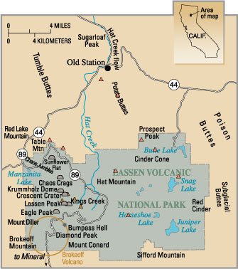
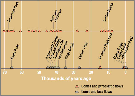
Eruptions in the Lassen volcanic area in the last 70,000 years. Circle shows base of Mount Tehama. See timeline image.
The Lassen volcanic area presents a geological record of sedimentation and volcanic activity in and around Lassen Volcanic National Park in Northern California, U.S. The park is located in the southernmost part of the Cascade Mountain Range in the Pacific Northwest region of the United States. Pacific Oceanic tectonic plates have plunged below the North American Plate in this part of North America for hundreds of millions of years. Heat and molten rock from these subducting plates has fed scores of volcanoes in California, Oregon, Washington and British Columbia over at least the past 30 million years, including these in the Lassen volcanic areas.
Between 3 and 4 million years ago, volcanic-derived mud flows called lahars streamed down several major mountains that included nearby but now extinct Mount Yana and Mount Maidu to become the Tuscan Formation. Basaltic and later andesitic to dacitic flows of lava covered increasingly larger areas of this formation to eventually form the lava plateau upon which the park is situated. About 600,000 years ago, Mount Tehama started to rise as a stratovolcano in the southwestern corner of the park, eventually reaching an estimated 11,000 ft (3,400 m) in height. (Full article...) - Image 10
 A natural diamond crystal
Diamond is a solid form of the element carbon with its atoms arranged in a crystal structure called diamond cubic. Diamond as a form of carbon is a tasteless, odourless, strong, and brittle solid that is transparent in colour, a poor conductor of electricity, and insoluble in water. Another solid form of carbon known as graphite is the chemically stable form of carbon at room temperature and pressure, but diamond is metastable and converts to it at a negligible rate under those conditions. Diamond has the highest hardness and thermal conductivity of any natural material, properties that are used in major industrial applications such as cutting and polishing tools. They are also the reason that diamond anvil cells can subject materials to pressures found deep in the Earth.
Because the arrangement of atoms in diamond is extremely rigid, few types of impurity can contaminate it (two exceptions are boron and nitrogen). Small numbers of defects or impurities (about one per million of lattice atoms) can color a diamond blue (boron), yellow (nitrogen), brown (defects), green (radiation exposure), purple, pink, orange, or red. Diamond also has a very high refractive index and a relatively high optical dispersion. (Full article...)

.jpg)

_-_Google_Art_Project.jpg)


.jpg)


 Vital article

Related portals
Get involved

 Featured biography
-Portrait-Portr_09852.tif_(cropped).jpg)
Did you know
- ... that the Danish geologist Tove Birkelund received a gold medal for her early work on fossils of Scaphites in Greenland?
- ... that from 1904 to 1911 Arthur Lewis Hall covered 17,479 miles (28,130 km), mostly on foot, to map the geology of the Transvaal?
- ... that the Central Asian Orogenic Belt is a leading laboratory of geologically recent crustal growth?
- ... that the groundwater level of a coastal aquifer system changes with the tide?
- ... that Frederick Murray Trotter had a distinguished career as a field geologist despite losing a part of his skull and an eye to shrapnel during World War I?
- ... that Karen Hanghøj, the 2023 winner of the William Smith Medal for applied geology, became the first female director of the British Geological Survey, 183 years after it was founded?
- ... that the Apollo 12 Solar Wind Spectrometer detected a gas-ion shockwave produced by the impact of the Apollo 13 S-IVB stage on the lunar surface?
- ... that the most significant rock from New Caledonia is peridotite, which comes from the Earth's mantle?
Top 10 WikiProject Geology Popular articles of the month
- Image 1The Blue Marble, Apollo 17, December 1972
Earth is the third planet from the Sun and the only astronomical object known to harbor life. This is enabled by Earth being an ocean world, the only one in the Solar System sustaining liquid surface water. Almost all of Earth's water is contained in its global ocean, covering 70.8% of Earth's crust. The remaining 29.2% of Earth's crust is land, most of which is located in the form of continental landmasses within Earth's land hemisphere. Most of Earth's land is somewhat humid and covered by vegetation, while large sheets of ice at Earth's polar deserts retain more water than Earth's groundwater, lakes, rivers and atmospheric water combined. Earth's crust consists of slowly moving tectonic plates, which interact to produce mountain ranges, volcanoes, and earthquakes. Earth has a liquid outer core that generates a magnetosphere capable of deflecting most of the destructive solar winds and cosmic radiation. (Full article...) - Image 2
Mount Everest is Earth's highest mountain above sea level, located in the Mahalangur Himal sub-range of the Himalayas. The China–Nepal border runs across its summit point. Its elevation (snow height) of 8,848.86 m (29,031 ft 8+1⁄2 in) was most recently established in 2020 by the Chinese and Nepali authorities. (Full article...) - Image 3
Animated, colour-coded map showing some continents and the region of Oceania (purple), which includes the continent of Australia. Depending on the convention and model, some continents may be consolidated or subdivided.
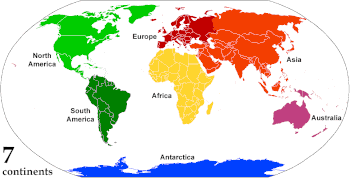
A continent is any of several large geographical regions. Continents are generally identified by convention rather than any strict criteria. A continent could be a single landmass or a part of a very large landmass, as in the case of Asia or Europe. Due to this, the number of continents varies; up to seven or as few as four geographical regions are commonly regarded as continents. Most English-speaking countries recognize seven regions as continents. In order from largest to smallest in area, these seven regions are Asia, Africa, North America, South America, Antarctica, Europe, and Australia. Different variations with fewer continents merge some of these regions; examples of this are merging North America and South America into America, Asia and Europe into Eurasia, and Africa, Asia, and Europe into Afro-Eurasia. (Full article...) - Image 4
The Chicxulub crater (IPA: [t͡ʃikʃuˈluɓ] ⓘ cheek-shoo-LOOB) is an impact crater buried underneath the Yucatán Peninsula in Mexico. Its center is offshore, but the crater is named after the onshore community of Chicxulub Pueblo (not the larger coastal town of Chicxulub Puerto). It was formed slightly over 66 million years ago when an asteroid, about ten kilometers (six miles) in diameter, struck Earth. The crater is estimated to be 200 kilometers (120 miles) in diameter and 20 kilometers (12 miles) in depth. It is believed to be the second largest impact structure on Earth, and the only one whose peak ring is intact and directly accessible for scientific research. (Full article...) - Image 5
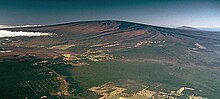 Mauna Loa as seen from the air.
Hualālai is visible in the background.
Mauna Loa (/ˌmɔːnə ˈloʊ.ə, ˌmaʊnə -/, Hawaiian: [ˈmɐwnə ˈlowə]; lit. 'Long Mountain') is one of five volcanoes that form the Island of Hawaii in the U.S. state of Hawaii in the Pacific Ocean. Mauna Loa is Earth's largest active volcano by both mass and volume. It was historically considered to be the largest volcano on Earth until Tamu Massif was discovered to be larger. Mauna Loa is a shield volcano with relatively gentle slopes, and a volume estimated at 18,000 cubic miles (75,000 km3), although its peak is about 125 feet (38 m) lower than that of its neighbor, Mauna Kea. Lava eruptions from Mauna Loa are silica-poor and very fluid, and tend to be non-explosive. (Full article...) - Image 6

Location of the Mariana Trench
The Mariana Trench is an oceanic trench located in the western Pacific Ocean, about 200 kilometres (124 mi) east of the Mariana Islands; it is the deepest oceanic trench on Earth. It is crescent-shaped and measures about 2,550 km (1,580 mi) in length and 69 km (43 mi) in width. The maximum known depth is 10,984 ± 25 metres (36,037 ± 82 ft; 6,006 ± 14 fathoms; 6.825 ± 0.016 mi) at the southern end of a small slot-shaped valley in its floor known as the Challenger Deep. The deepest point of the trench is more than 2 km (1.2 mi) farther from sea level than the peak of Mount Everest. (Full article...) - Image 7

The eight planets of the Solar System with size to scale (up to down, left to right): Saturn, Jupiter, Uranus, Neptune (outer planets), Earth, Venus, Mars, and Mercury (inner planets)
A planet is a large, rounded astronomical body that is generally required to be in orbit around a star, stellar remnant, or brown dwarf, and is not one itself. The Solar System has eight planets by the most restrictive definition of the term: the terrestrial planets Mercury, Venus, Earth, and Mars, and the giant planets Jupiter, Saturn, Uranus, and Neptune. The best available theory of planet formation is the nebular hypothesis, which posits that an interstellar cloud collapses out of a nebula to create a young protostar orbited by a protoplanetary disk. Planets grow in this disk by the gradual accumulation of material driven by gravity, a process called accretion. (Full article...) - Image 8Mount Vesuvius (/vɪˈsuːviəs/ viss-OO-vee-əs) is a somma–stratovolcano located on the Gulf of Naples in Campania, Italy, about 9 km (5.6 mi) east of Naples and a short distance from the shore. It is one of several volcanoes forming the Campanian volcanic arc. Vesuvius consists of a large cone partially encircled by the steep rim of a summit caldera, resulting from the collapse of an earlier, much higher structure. (Full article...)
- Image 9
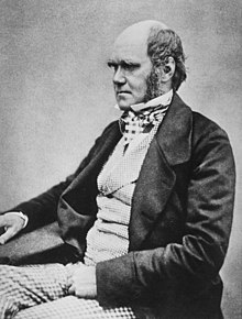 Darwin, c. 1854, when he was preparing On the Origin of Species
Charles Robert Darwin FRS FRGS FLS FZS JP (/ˈdɑːrwɪn/ DAR-win; 12 February 1809 – 19 April 1882) was an English naturalist, geologist, and biologist, widely known for his contributions to evolutionary biology. His proposition that all species of life have descended from a common ancestor is now generally accepted and considered a fundamental scientific concept. In a joint publication with Alfred Russel Wallace, he introduced his scientific theory that this branching pattern of evolution resulted from a process he called natural selection, in which the struggle for existence has a similar effect to the artificial selection involved in selective breeding. Darwin has been described as one of the most influential figures in human history and was honoured by burial in Westminster Abbey. (Full article...) - Image 10
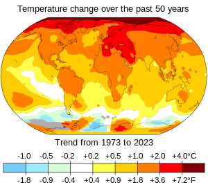
Changes in surface air temperature over the past 50 years. The Arctic has warmed the most, and temperatures on land have generally increased more than sea surface temperatures.
In common usage, climate change describes global warming—the ongoing increase in global average temperature—and its effects on Earth's climate system. Climate change in a broader sense also includes previous long-term changes to Earth's climate. The current rise in global average temperature is primarily caused by humans burning fossil fuels since the Industrial Revolution. Fossil fuel use, deforestation, and some agricultural and industrial practices add to greenhouse gases. These gases absorb some of the heat that the Earth radiates after it warms from sunlight, warming the lower atmosphere. Carbon dioxide, the primary greenhouse gas driving global warming, has grown by about 50% and is at levels unseen for millions of years. (Full article...)


Featured pictures


Main articles
 Categories
Selected pictures
 Image 1Map: Grandiose, based on a map by the United States Geological SurveyA geological map of Yosemite National Park (full size), showing the Cathedral Peak Granodiorite, the largest unit in the Tuolumne Intrusive Suite, which in turn is the largest granitic suite in the park.
Cathedral Peak Granodiorite
Rest of the Tuolumne Intrusive Suite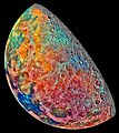 Image 2Image credit: Galileo spacecraftThis false-color mosaic showing compositional variations in the geology of the Moon was constructed from a series of 53 images taken through three spectral filters by the imaging system of the Galileo spacecraft. Bright pinkish areas are highlands materials, such as those surrounding the oval lava-filled Mare Crisium impact basin toward the bottom. Blue to orange shades indicate volcanic lava flows. To the left of Crisium, the dark blue Mare Tranquillitatis is richer in titanium than the green and orange maria above it. Thin mineral-rich soils associated with relatively recent impacts are represented by light blue colors. The monochrome band on the right edge shows the unretouched surface of the moon.
 Image 3Curiosity is a car-sized rover designed to explore the crater Gale on Mars as part of NASA's Mars Science Laboratory mission. It was launched from Cape Canaveral in November 2011 and landed on Aeolis Palus inside Gale on August 6, 2012, at 05:17 UTC. Curiosity's landing site, nicknamed Bradbury Landing, was less than 2.4 km (1.5 mi) from the center of the rover's touchdown target after a 560-million km (350-million mi) journey. The rover's goals include an investigation of the Martian climate and geology; assessment of whether the selected field site inside Gale has ever offered environmental conditions favorable for microbial life, including investigation of the role of water; as well as planetary habitability studies in preparation for human exploration.
This picture is a self-portrait of Curiosity on Mars at the "Big Sky" drilling site, where it collected a rock sample at the foothills of Aeolis Mons (Mount Sharp) in October 2015. The photograph combines dozens of images taken by the Mars Hand Lens Imager (MAHLI) camera at the end of the rover's robotic arm; the arm itself is not included, although its shadow is visible on the ground. Wrist motions and turret rotations on the arm allowed MAHLI to acquire the mosaic's component images. Image 4Map: Strebe, using GeocartThe Lambert azimuthal equal-area projection is a projection used for mapping a sphere to a disk. It accurately represents area in all regions of the sphere, but it does not accurately represent angles. It is used in scientific disciplines such as geology for plotting the orientations of lines in three-dimensional space, and by the National Atlas of the US in its online map-making application.
 Image 5Cartographic relief depiction showing the varying age of bedrock underlying North America. This image combines a geologic map and a shaded relief image. This combination reveals the geologic history of North America through the interrelation of rock type, topography and time. Regional surface processes as well as continent-scale tectonic events are exposed in the three dimensions of space and the fourth dimension, geologic time. From most recent to oldest, age is indicated by color: yellow, green, blue, red.


Associated Wikimedia
The following Wikimedia Foundation sister projects provide more on this subject:
-
 Commons
Free media repository -
 Wikibooks
Free textbooks and manuals -
 Wikidata
Free knowledge base -
 Wikinews
Free-content news -
 Wikiquote
Collection of quotations -
 Wikisource
Free-content library -
 Wikiversity
Free learning tools -
 Wikivoyage
Free travel guide -
 Wiktionary
Dictionary and thesaurus


