File:Outre-mer_en.png
維基百科,自由的 encyclopedia
本预览的尺寸:800 × 400像素。 其他分辨率:320 × 160像素 | 640 × 320像素 | 1,480 × 740像素。
原始文件 (1,480 × 740像素,文件大小:54 KB,MIME类型:image/png)
摘要
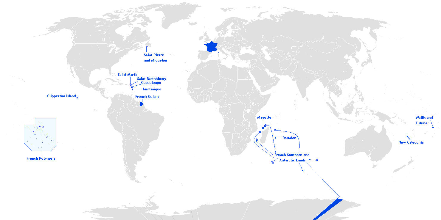
English: This is a translation from esperanto (by Hoshie) into english of User:Manchot sanguinaire's map of French Overseas départements, regions, collectivités, and territories, which is at Image:Outre-mer eo.png. The translations of the names into english are the names used in the CIA World Factbook. I also also added the five Îles Éparses that surround Madagascar. The source for their placement on the map is the CIA Factbook map of the area, which is here on Commons at Image:Iles Eparses-CIA WFB Map.png. The placement of Adélie Land is based upon Image:Antarctica territorial claims.png by User:Astrokey44. Since the original map is GFDL, this one is too.

|
此locator map图片可使用矢量图形重新创建为SVG文件。这具有很多好处;更多信息请参见共享资源:待清理媒体。如果存在此图片的SVG格式,请将其上传,然后将此模板替换为
{{vector version available|新图片名称}}。
建议您将SVG命名为“Outre-mer en.svg”,这样在使用Vector version available(或Vva)模板时就不需要填写新图片名称参数。 |
许可协议
Hoshie,本作品著作权人,特此采用以下许可协议发表本作品:

|
已授权您依据自由软件基金会发行的无固定段落及封面封底文字(Invariant Sections, Front-Cover Texts, and Back-Cover Texts)的GNU自由文件许可协议1.2版或任意后续版本的条款,复制、传播和/或修改本文件。该协议的副本请见“GNU Free Documentation License”。http://www.gnu.org/copyleft/fdl.htmlGFDLGNU Free Documentation Licensetruetrue |
| 本文件采用知识共享署名-相同方式共享 3.0 未本地化版本许可协议授权。 | ||
| 署名: Hoshie | ||
| ||
| 本许可协议标签作为GFDL许可协议更新的组成部分被添加至本文件。http://creativecommons.org/licenses/by-sa/3.0/CC BY-SA 3.0Creative Commons Attribution-Share Alike 3.0truetrue |
说明
添加一行文字以描述该文件所表现的内容
Map of France's overseas possessions as of 2020
Fransız deniz aşırı toprakları
此文件中描述的项目
描繪內容
文件历史
点击某个日期/时间查看对应时刻的文件。
| 日期/时间 | 缩略图 | 大小 | 用户 | 备注 | |
|---|---|---|---|---|---|
| 当前 | 2018年3月27日 (二) 20:27 | | 1,480 × 740(54 KB) | Maphobbyist | Upload |
| 2016年2月28日 (日) 09:12 |  | 1,480 × 740(54 KB) | Kontrollstellekundl | Polynesia colour | |
| 2013年7月24日 (三) 13:15 |  | 1,480 × 740(44 KB) | DrKay | remove dark grey areas in Antartica, Dniestr, Kosovo, Palestine, etc. | |
| 2012年2月12日 (日) 20:41 |  | 1,480 × 740(75 KB) | Spesh531 | +south sudan, antarctic territories, other lands, change color of land, fixed boudaries, added accents on e in R e union and Saint Barth e lemy, fixed islands in French Polynesia | |
| 2007年12月17日 (一) 03:12 |  | 1,432 × 742(58 KB) | Rosss | More accurate shape for French Polynesia | |
| 2007年4月22日 (日) 02:44 |  | 1,432 × 742(39 KB) | Kelvinc | fixed shading of antarctica east of adelie land | |
| 2007年4月17日 (二) 09:59 |  | 1,432 × 742(26 KB) | Tene~commonswiki | Optimised (0) | |
| 2007年3月5日 (一) 14:14 |  | 1,432 × 742(60 KB) | Hoshie | added Antarctica itself to the image and marked the French claim. The position of St.-Barth and St.-Martin has been fixed | |
| 2007年3月4日 (日) 18:26 |  | 1,357 × 628(53 KB) | Hoshie | removed labels for the Iles Eparses, since they are a part of the TAAF; see http://www.taaf.fr/rubriques/iles/iles_introduction.htm | |
| 2007年3月2日 (五) 07:11 |  | 1,357 × 628(54 KB) | Hoshie | fixed map to include St.-Martin and St.-Barth. |
文件用途
以下31个页面使用本文件:
全域文件用途
以下其他wiki使用此文件:
- af.wikipedia.org上的用途
- ar.wikipedia.org上的用途
- as.wikipedia.org上的用途
- az.wikipedia.org上的用途
- bcl.wikipedia.org上的用途
- be.wikipedia.org上的用途
- ca.wikipedia.org上的用途
- da.wikipedia.org上的用途
- de.wikipedia.org上的用途
- el.wikipedia.org上的用途
- en.wikipedia.org上的用途
- Portal:France/Geography
- Portal:France/Administrative divisions
- Template:Infobox European Parliament constituency
- Overseas Territories of France (European Parliament constituency)
- Template:Infobox European Parliament constituency/doc
- Overseas France
- File talk:Outre-mer en.png
- Template:Infobox European Parliament constituency/sandbox
- eo.wikipedia.org上的用途
- es.wikipedia.org上的用途
- et.wikipedia.org上的用途
- eu.wikipedia.org上的用途
查看此文件的更多全域用途。
元数据
此文件中包含有扩展的信息。这些信息可能是由数码相机或扫描仪在创建或数字化过程中所添加。
如果此文件的源文件已经被修改,一些信息在修改后的文件中将不能完全反映出来。
| 水平分辨率 | 37.8 dpc |
|---|---|
| 垂直分辨率 | 37.8 dpc |