File:WWI-re.png
From Wikipedia, the free encyclopedia
預覽大細:800 × 338 像素。 第啲解像度:320 × 135 像素|640 × 270 像素|1,480 × 625 像素。
原本檔案 (1,480 × 625 像素,檔案大細:42 KB ,MIME類型:image/png)
摘要
| 描述WWI-re.png |
Afrikaans: Kaart van die wêreld wat die deelnemers in die Eerste Wêreldoorlog:
Bahasa Indonesia: Peta negara-negara yang berpartisipasi dalam Perang Dunia I:
Bahasa Melayu: Peta Dunia menunjukkan peserta-peserta dalam Perang Dunia I:
Català: Mapa del Món que mostra als participants en la Primera Guerra Mundial:
Dansk: Kort over verden viser deltagerne i 1. verdenskrig:
Deutsch: Karte der am Ersten Weltkrieg beteiligten Länder:
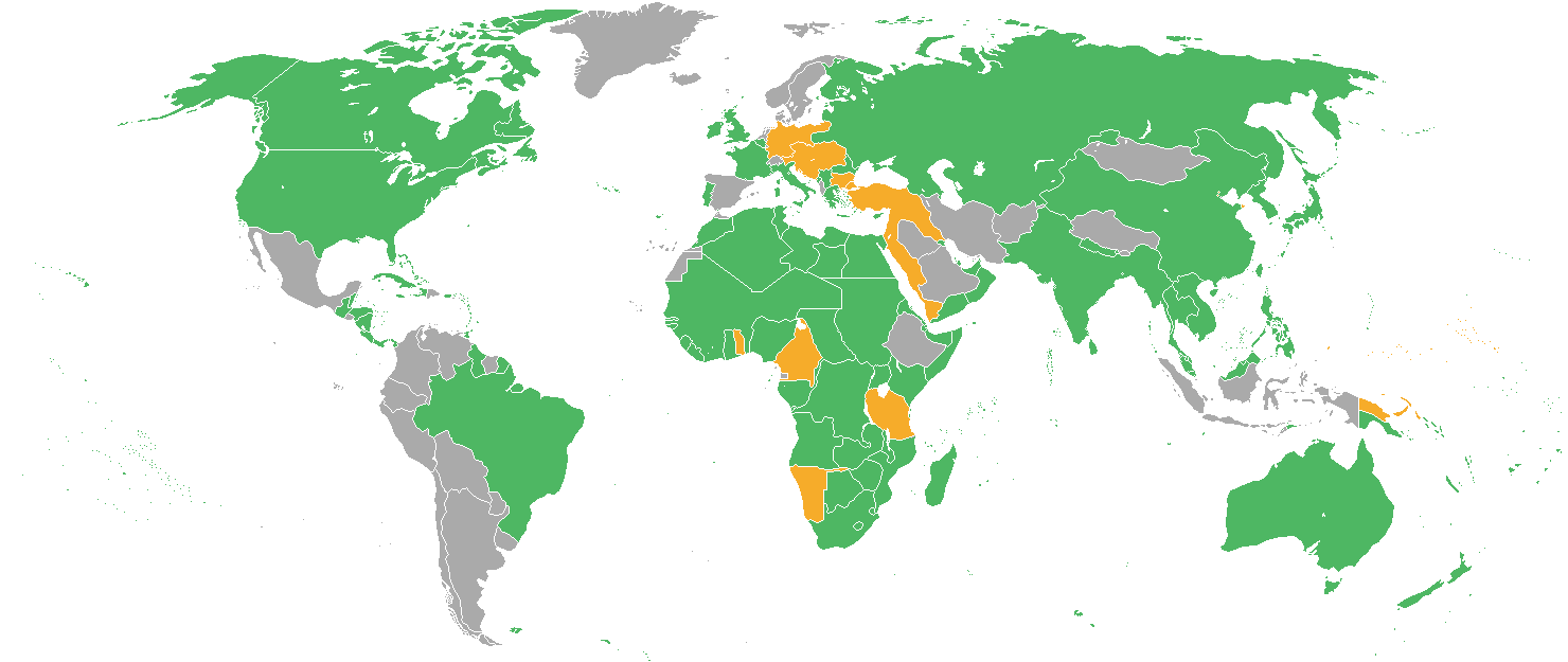
English: Map of the World showing the participants in World War I:
Español: Mapa del Mundo que muestra a los participantes en la Primera Guerra Mundial:
Français : Carte du monde montrant les participants à la Première Guerre mondiale :
Italiano: Mappa del Mondo mostrando i partecipanti nella prima guerra mondiale:
Latina: Bellum Orbis Terrarum Primum participes ostendens:
Magyar: Világtérkép mutatja a résztvevők az I. világháborúban:
Nederlands: Kaart van de Wereld met de deelnemers in de Eerste Wereldoorlog:
Română: Hartă a lumii reprezentând participanții la Primul Război Mondial:
Slovenčina: Mapa sveta ukazuje účastníkov prvej svetovej vojny:
Suomi: Maailman kartta osoittaa osallistujille maailmansota:
Svenska: Världskarta som visar deltagarna i första världskriget:
Türkçe: I. Dünya Savaşı'nda katılımcılara gösteren Dünya Haritası:
Русский: На карте мира указанны участники Первой мировой войны:
Српски / srpski: Карта света показује учесницима у Првом светском рату:
ქართული: ವಿಶ್ವಯುದ್ಧದ ಭಾಗವಹಿಸುವವರ ತೋರಿಸುವ ವಿಶ್ವ ನಕ್ಷೆ:
தமிழ் : உலக போர் நான் பங்கேற்பாளர்கள் காட்டும் உலக வரைபடம்:
ไทย: แผนที่โลกแสดงฝ่ายในสงครามโลกครั้งที่หนึ่ง:
한국어: 제 1차 세계 대전의 참가자를 보여주는 세계지도 :
日本語: 第一次世界大戦での参加国を示す世界地図:
中文(简体): 第一次世界大战参战国地图:
中文(繁體): 第一次世界大戰參戰國地圖:
עברית : מפת העולם המציגה את המשתתפים במלחמת העולם הראשונה:
العربية : :خريطة للعالم تظهر للمشاركين في الحرب العالمية الأولى
|
| 日期 | |
| 來源 | 自己作品 (originally at en.wikipedia) |
| 作者 | Thomashwang |

|
This military map image could be recreated using vector graphics as an SVG file. This has several advantages; see Commons:Media for cleanup for more information. If an SVG form of this image is already available, please upload it. After uploading an SVG, replace this template with {{vector version available|new image name.svg}}.
|
協議
Thomashwang from en.wikipedia.org, the copyright holder of this work, hereby publishes it under the following license:

|
根據自由軟體基金會發佈嘅無固定段落、封面文字同封底文字GNU自由文件授權條款第1.2或打後嘅版本,你獲授權可以重製、散佈同埋修改爾份文件。授權條款嘅副本喺章節GNU自由文件授權條款。http://www.gnu.org/copyleft/fdl.htmlGFDLGNU Free Documentation Licensetruetrue |
| 呢個檔案用共享創意 姓名標示-非商業性-相同方式分享3.0 未本地化版本條款授權。 | ||
| 姓名標示: Thomashwang | ||
| ||
| This licensing tag was added to this file as part of the GFDL licensing update.http://creativecommons.org/licenses/by-sa/3.0/CC BY-SA 3.0Creative Commons Attribution-Share Alike 3.0truetrue |
Captions
Add a one-line explanation of what this file represents
Parteien im Ersten Weltkrieg
I.Dünya savaşı başlamadan önceki birbirleriyle müttefik olan devletlerin haritası
黄色部分为同盟国及其海外殖民地
Tous les participants de la Première Guerre mondiale : les Alliés en vert, les Empires centraux en orange, et les pays neutres en gris.
Items portrayed in this file
圖中顯示嘅係
6 5 2006
image/png
檔案歷史
撳個日期/時間去睇響嗰個時間出現過嘅檔案。
| 日期/時間 | 縮圖 | 尺寸 | 用戶 | 註解 | |
|---|---|---|---|---|---|
| 現時 | 2020年10月8號 (四) 08:44 | | 1,480 × 625(42 KB) | AKS471883 | Tibet |
| 2017年11月26號 (日) 22:05 |  | 1,480 × 625(42 KB) | AHC300 | Albania | |
| 2016年5月20號 (五) 06:53 |  | 1,480 × 625(42 KB) | AKS471883 | 8+5 | |
| 2016年5月20號 (五) 06:43 |  | 1,480 × 625(44 KB) | AKS471883 | Bogd Khaanate of Mongolia (1911-1919) | |
| 2014年3月5號 (三) 05:04 |  | 1,480 × 625(53 KB) | Grachifan | marking tsingtau as german | |
| 2014年2月28號 (五) 03:47 |  | 1,480 × 625(42 KB) | Lothar von Richthofen | Reverted to version as of 15:49, 29 April 2013 reverting, too many complications and errors introduced | |
| 2014年2月27號 (四) 18:05 |  | 1,502 × 625(53 KB) | Grachifan | adding ecuador and peru | |
| 2014年2月23號 (日) 15:40 |  | 1,502 × 719(44 KB) | The Northaptonshire pins | Fixed Libya. | |
| 2014年2月23號 (日) 15:31 |  | 1,502 × 719(44 KB) | The Northaptonshire pins | Irish fixed. | |
| 2014年2月23號 (日) 15:17 |  | 1,502 × 719(44 KB) | The Northaptonshire pins | Fixes like Dafur and Persia. |
檔案用途
全域檔案使用情況
下面嘅維基都用緊呢個檔案:
- af.wikipedia.org嘅使用情況
- ar.wikipedia.org嘅使用情況
- arz.wikipedia.org嘅使用情況
- as.wikipedia.org嘅使用情況
- azb.wikipedia.org嘅使用情況
- be.wikipedia.org嘅使用情況
- bg.wikipedia.org嘅使用情況
- bn.wikipedia.org嘅使用情況
- br.wikipedia.org嘅使用情況
- bs.wikipedia.org嘅使用情況
- bxr.wikipedia.org嘅使用情況
- ca.wikipedia.org嘅使用情況
- ceb.wikipedia.org嘅使用情況
- ckb.wikipedia.org嘅使用情況
- crh.wikipedia.org嘅使用情況
- cs.wikipedia.org嘅使用情況
- cv.wikipedia.org嘅使用情況
- da.wikipedia.org嘅使用情況
- de.wikipedia.org嘅使用情況
- de.wikibooks.org嘅使用情況
- dsb.wikipedia.org嘅使用情況
- el.wikipedia.org嘅使用情況
- eml.wikipedia.org嘅使用情況
- en.wikipedia.org嘅使用情況
睇呢個檔案嘅更多全域使用情況。
Metadata
呢個檔案有額外嘅資料。佢應該係數碼相機或者掃描器整出來嘅。如果佢整咗之後畀人改過,裏面嘅資料未必同改過之後相符。
| 橫解像度 | 37.8 dpc |
|---|---|
| 直解像度 | 37.8 dpc |