File:Geostationaryjava3D.gif
維基百科,自由的 encyclopedia
此為最大尺寸。
Geostationaryjava3D.gif (220 × 220 像素,檔案大小:227 KB,MIME 類型:image/gif、循環、183 畫格、14秒)
摘要
| 描述Geostationaryjava3D.gif |
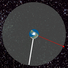
English: Top View of Geostationary orbit. To an observer on the rotating Earth (Africa on the Earth ), the satellite appears stationary in the sky as shown by the yellow radius. A red satellite is also geostationary above its own point on the Earth (Singapore)
http://weelookang.blogspot.com/2010/07/ejs-open-source-geostationary-satellite.html |
| 日期 | |
| 來源 | 自己的作品 |
| 作者 | Lookang many thanks to author of original simulation = Francisco Esquembre author of Easy Java Simulation = Francisco Esquembre |
授權條款
我,本作品的著作權持有者,決定用以下授權條款發佈本作品:
此檔案採用共享創意 姓名標示-相同方式分享 3.0 未在地化版本授權條款。
- 您可以自由:
- 分享 – 複製、發佈和傳播本作品
- 重新修改 – 創作演繹作品
- 惟需遵照下列條件:
- 姓名標示 – 您必須指名出正確的製作者,和提供授權條款的連結,以及表示是否有對內容上做出變更。您可以用任何合理的方式來行動,但不得以任何方式表明授權條款是對您許可或是由您所使用。
- 相同方式分享 – 如果您利用本素材進行再混合、轉換或創作,您必須基於如同原先的相同或兼容的條款,來分布您的貢獻成品。
說明
添加單行說明來描述出檔案所代表的內容
Top View of Geostationary orbit
Geosynchronous Orbit
ಸಾಗರದ ಮಟ್ಟದಿಂದ ೩೫೭೮೬ ಕಿಮೀ ಎತ್ತರದಲ್ಲಿ ಭೂಮಿಯನ್ನು ಸುತ್ತುವ ಭೂ ಸ್ಥಿರಪಥ ಉಪಗ್ರಹ
共享創意署名-相同方式共享3.0Unported Chinese (Hong Kong) (已轉換拼寫)
27 6 2011
多媒體型式 繁體中文 (已轉換拼寫)
image/gif
檔案歷史
點選日期/時間以檢視該時間的檔案版本。
| 日期/時間 | 縮圖 | 尺寸 | 用戶 | 備註 | |
|---|---|---|---|---|---|
| 目前 | 2013年6月12日 (三) 02:45 | | 220 × 220(227 KB) | Lookang | updated to 2013 version |
| 2011年6月27日 (一) 01:22 |  | 220 × 220(480 KB) | Lookang | Geostationary orbit.To an observer on the rotating Earth (fixed point on the Earth), the satellite appears stationary in the sky. A red satellite is also geostationary above its own point on Earth. Top Down View | |
| 2011年6月27日 (一) 01:14 |  | 280 × 280(677 KB) | Lookang | trying to make the thumbnail animated by using comtasia 7 | |
| 2011年6月27日 (一) 01:08 |  | 280 × 280(624 KB) | Lookang | Geostationary orbit.To an observer on the rotating Earth (fixed point on the Earth), the satellite appears stationary in the sky. A red satellite is also geostationary above its own point on Earth. Top Down View | |
| 2011年6月27日 (一) 01:06 |  | 300 × 300(625 KB) | Lookang | Geostationary orbit.To an observer on the rotating Earth (fixed point on the Earth), the satellite appears stationary in the sky. A red satellite is also geostationary above its own point on Earth. Top Down View. | |
| 2011年6月27日 (一) 00:57 |  | 300 × 300(653 KB) | Lookang |
檔案用途
下列頁面有用到此檔案:
全域檔案使用狀況
以下其他 wiki 使用了這個檔案:
- af.wikipedia.org 的使用狀況
- an.wikipedia.org 的使用狀況
- ar.wikipedia.org 的使用狀況
- ast.wikipedia.org 的使用狀況
- bn.wikipedia.org 的使用狀況
- bs.wikipedia.org 的使用狀況
- ca.wikipedia.org 的使用狀況
- en.wikipedia.org 的使用狀況
- es.wikipedia.org 的使用狀況
- et.wikipedia.org 的使用狀況
- fa.wikipedia.org 的使用狀況
- gl.wikipedia.org 的使用狀況
- he.wikipedia.org 的使用狀況
- hi.wikipedia.org 的使用狀況
- hr.wikipedia.org 的使用狀況
- hu.wikipedia.org 的使用狀況
- hy.wikipedia.org 的使用狀況
- io.wikipedia.org 的使用狀況
- kn.wikipedia.org 的使用狀況
- ml.wikipedia.org 的使用狀況
- ms.wikipedia.org 的使用狀況
- pl.wikipedia.org 的使用狀況
- pnb.wikipedia.org 的使用狀況
- pt.wikipedia.org 的使用狀況
- ru.wikipedia.org 的使用狀況
- ru.wikinews.org 的使用狀況
- simple.wikipedia.org 的使用狀況
- si.wikipedia.org 的使用狀況
- sl.wikipedia.org 的使用狀況
- sr.wikipedia.org 的使用狀況
- ta.wikipedia.org 的使用狀況
- te.wikipedia.org 的使用狀況
- tg.wikipedia.org 的使用狀況
- th.wikipedia.org 的使用狀況
- ur.wikipedia.org 的使用狀況
- vi.wikipedia.org 的使用狀況
- www.wikidata.org 的使用狀況
- zh-yue.wikipedia.org 的使用狀況
詮釋資料
此檔案中包含擴展的資訊。這些資訊可能是由數位相機或掃描器在建立時或數位化過程中所加入。
如果此檔案的來源檔案已被修改,一些資訊在修改後的檔案中將不能完全反映出來。
| GIF 檔案備註 | Title: geostationaryjava3d2013 Author: lookang |
|---|