File:Outre-mer_en.png
維基百科,自由的 encyclopedia
預覽大小:800 × 400 像素。 其他解析度:320 × 160 像素 | 640 × 320 像素 | 1,480 × 740 像素。
原始檔案 (1,480 × 740 像素,檔案大小:54 KB,MIME 類型:image/png)
摘要
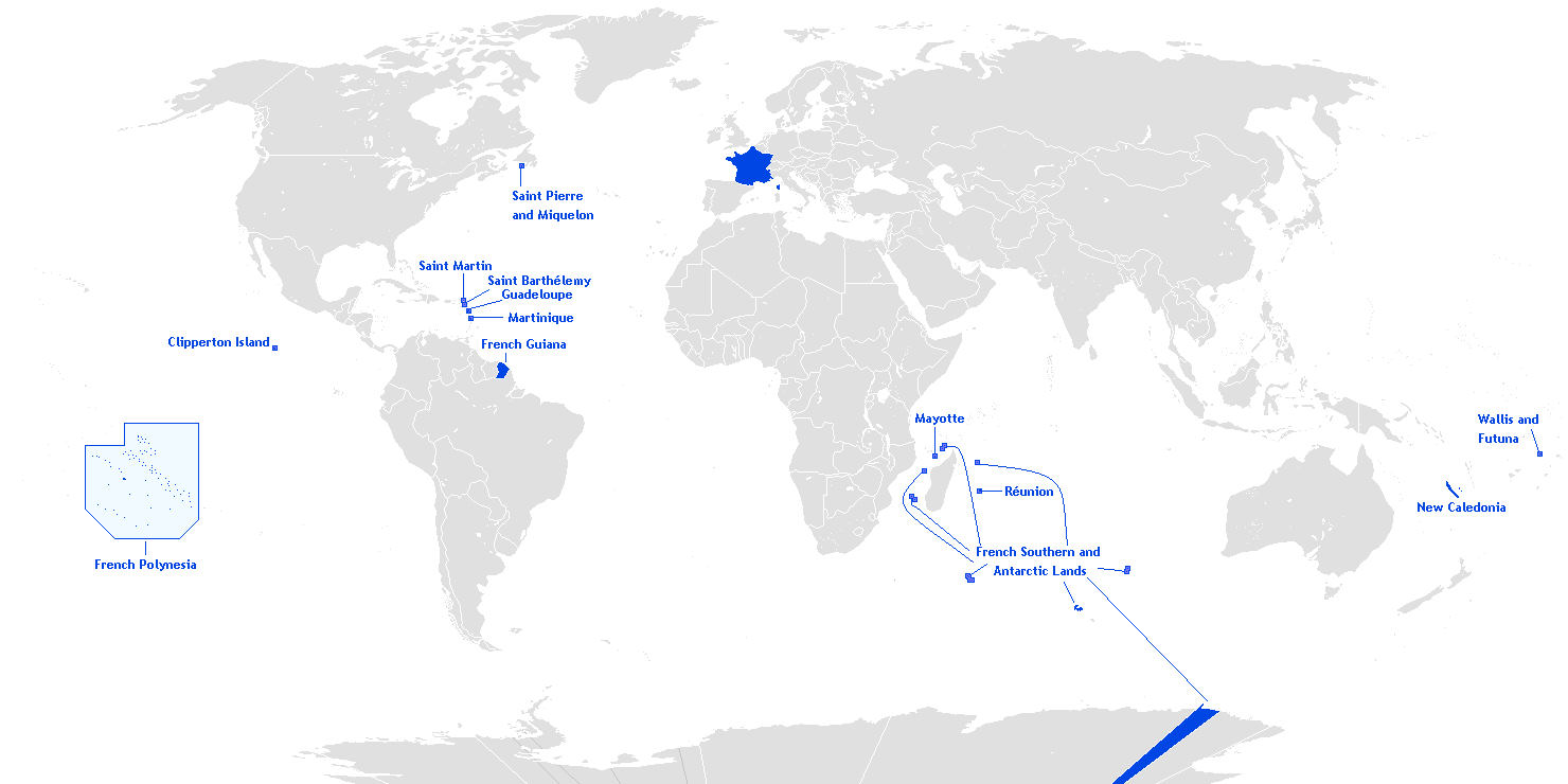
English: This is a translation from esperanto (by Hoshie) into english of User:Manchot sanguinaire's map of French Overseas départements, regions, collectivités, and territories, which is at Image:Outre-mer eo.png. The translations of the names into english are the names used in the CIA World Factbook. I also also added the five Îles Éparses that surround Madagascar. The source for their placement on the map is the CIA Factbook map of the area, which is here on Commons at Image:Iles Eparses-CIA WFB Map.png. The placement of Adélie Land is based upon Image:Antarctica territorial claims.png by User:Astrokey44. Since the original map is GFDL, this one is too.

|
本圖片是以PNG、GIF或JPEG格式上傳。然而,其中包含的資料或訊息,應該重新建立成可縮放向量圖形(SVG)檔案,以更有效率或更準確的方式儲存。如有可能,請上傳本圖片的SVG格式版本。在上傳之後,請修改維基各姊妹計畫中所有使用舊版圖片的條目(列在圖像連結章節中),替換為新版圖片,並在舊圖片的描述頁中加入{{Vector version available|新圖片名稱.svg}}模板,同時移除本模板。
|
授權條款
Hoshie,此作品的版權所有人,決定用以下授權條款發佈本作品:

|
已授權您依據自由軟體基金會發行的無固定段落、封面文字和封底文字GNU自由文件授權條款1.2版或任意後續版本,對本檔進行複製、傳播和/或修改。該協議的副本列在GNU自由文件授權條款中。http://www.gnu.org/copyleft/fdl.htmlGFDLGNU Free Documentation Licensetruetrue |
| 此檔案採用創用CC 姓名標示-相同方式分享 3.0 未在地化版本授權條款。 | ||
| 姓名標示: Hoshie | ||
| ||
| 已新增授權條款標題至此檔案,作為GFDL授權更新的一部份。http://creativecommons.org/licenses/by-sa/3.0/CC BY-SA 3.0Creative Commons Attribution-Share Alike 3.0truetrue |
說明
添加單行說明來描述出檔案所代表的內容
Map of France's overseas possessions as of 2020
Fransız deniz aşırı toprakları
在此檔案描寫的項目
描繪內容
檔案歷史
點選日期/時間以檢視該時間的檔案版本。
| 日期/時間 | 縮圖 | 尺寸 | 使用者 | 備註 | |
|---|---|---|---|---|---|
| 目前 | 2018年3月27日 (二) 20:27 | | 1,480 × 740(54 KB) | Maphobbyist | Upload |
| 2016年2月28日 (日) 09:12 |  | 1,480 × 740(54 KB) | Kontrollstellekundl | Polynesia colour | |
| 2013年7月24日 (三) 13:15 |  | 1,480 × 740(44 KB) | DrKay | remove dark grey areas in Antartica, Dniestr, Kosovo, Palestine, etc. | |
| 2012年2月12日 (日) 20:41 |  | 1,480 × 740(75 KB) | Spesh531 | +south sudan, antarctic territories, other lands, change color of land, fixed boudaries, added accents on e in R e union and Saint Barth e lemy, fixed islands in French Polynesia | |
| 2007年12月17日 (一) 03:12 |  | 1,432 × 742(58 KB) | Rosss | More accurate shape for French Polynesia | |
| 2007年4月22日 (日) 02:44 |  | 1,432 × 742(39 KB) | Kelvinc | fixed shading of antarctica east of adelie land | |
| 2007年4月17日 (二) 09:59 |  | 1,432 × 742(26 KB) | Tene~commonswiki | Optimised (0) | |
| 2007年3月5日 (一) 14:14 |  | 1,432 × 742(60 KB) | Hoshie | added Antarctica itself to the image and marked the French claim. The position of St.-Barth and St.-Martin has been fixed | |
| 2007年3月4日 (日) 18:26 |  | 1,357 × 628(53 KB) | Hoshie | removed labels for the Iles Eparses, since they are a part of the TAAF; see http://www.taaf.fr/rubriques/iles/iles_introduction.htm | |
| 2007年3月2日 (五) 07:11 |  | 1,357 × 628(54 KB) | Hoshie | fixed map to include St.-Martin and St.-Barth. |
檔案用途
下列31個頁面有用到此檔案:
全域檔案使用狀況
以下其他 wiki 使用了這個檔案:
- af.wikipedia.org 的使用狀況
- ar.wikipedia.org 的使用狀況
- as.wikipedia.org 的使用狀況
- az.wikipedia.org 的使用狀況
- bcl.wikipedia.org 的使用狀況
- be.wikipedia.org 的使用狀況
- ca.wikipedia.org 的使用狀況
- da.wikipedia.org 的使用狀況
- de.wikipedia.org 的使用狀況
- el.wikipedia.org 的使用狀況
- en.wikipedia.org 的使用狀況
- Portal:France/Geography
- Portal:France/Administrative divisions
- Template:Infobox European Parliament constituency
- Overseas Territories of France (European Parliament constituency)
- Template:Infobox European Parliament constituency/doc
- Overseas France
- File talk:Outre-mer en.png
- Template:Infobox European Parliament constituency/sandbox
- eo.wikipedia.org 的使用狀況
- es.wikipedia.org 的使用狀況
- et.wikipedia.org 的使用狀況
- eu.wikipedia.org 的使用狀況
檢視此檔案的更多全域使用狀況。
詮釋資料
此檔案中包含其他資訊,這些資訊可能是由數位相機或掃描器在建立或數位化過程中所新增的。若檔案自原始狀態已被修改,一些詳細資料可能無法完整反映出已修改的檔案。
| 水平解析度 | 37.8 dpc |
|---|---|
| 垂直解析度 | 37.8 dpc |