From Wikipedia, the free encyclopedia
رنگا ریڈی ضلع (انگریزی: Ranga Reddy district) بھارت کا ایک ضلع جو تلنگانہ میں واقع ہے۔[1]
రంగా రెడ్డి జిల్లా | |
|---|---|
| District of Telangana | |
| سرکاری نام | |
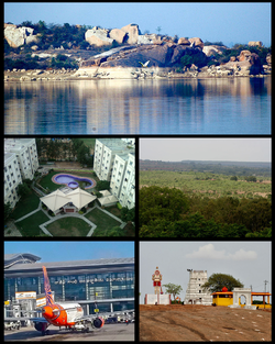
 Rangareddy District Montage. Clockwise from Top Left: شامیر پیٹ lake view, Ananthagiri Forests at وقار آباد, Keesaragutta Temple, راجیو گاندھی بین الاقوامی ہوائی اڈا at شمس آباد, Residential buildings in میاپور. | |
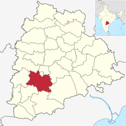
 Location in Telangana, India | |
| ملک | |
| ریاست | تلنگانہ |
| وجہ تسمیہ | Konda Venkata Ranga Reddy |
| رقبہ | |
| • کل | 7,493 کلومیٹر2 (2,893 میل مربع) |
| آبادی (2011 Census) | |
| • کل | 5,296,741 |
| زبانیں | |
| • دفتری | تیلگو زبان, اردو |
| منطقۂ وقت | بھارتی معیاری وقت (UTC+5:30) |
| ڈاک اشاریہ رمز | 500 xxx |
| رمز ٹیلی فون | 91- |
| گاڑی کی نمبر پلیٹ | TS-07, TS-08 |
| Climate | بھارت کے موسمی خطے (کوپن کی موسمی زمرہ بندی) |
| بارندگی | 603 ملیمیٹر (23.7 انچ) |
| Avg. annual temperature | 26.0 °C (78.8 °F) |
| Avg. summer temperature | 45.9 °C (114.6 °F) |
| Avg. winter temperature | 23.5 °C (74.3 °F) |
| ویب سائٹ | rangareddy |
رنگا ریڈی ضلع کا رقبہ 7,493 مربع کیلومیٹر ہے اور اس کی مجموعی آبادی 5,296,741 افراد پر مشتمل ہے۔
Seamless Wikipedia browsing. On steroids.
Every time you click a link to Wikipedia, Wiktionary or Wikiquote in your browser's search results, it will show the modern Wikiwand interface.
Wikiwand extension is a five stars, simple, with minimum permission required to keep your browsing private, safe and transparent.