File:Hurricane_katrina_damage_gulfport_mississippi.jpg
From Wikipedia, the free encyclopedia
Dokument origjinal ((përmasa 3.008 × 2.000 px, madhësia skedës: 2,64 MB, lloji MIME: image/jpeg))
| Kjo skedë është prej Wikimedia Commons dhe mund të përdoret nga projekte të tjera. Përshkrimi në këtë skedë në këtë faqe nuk është treguar më poshtë. | Shko tek faqja përshkruese në Commons |
Përmbledhje
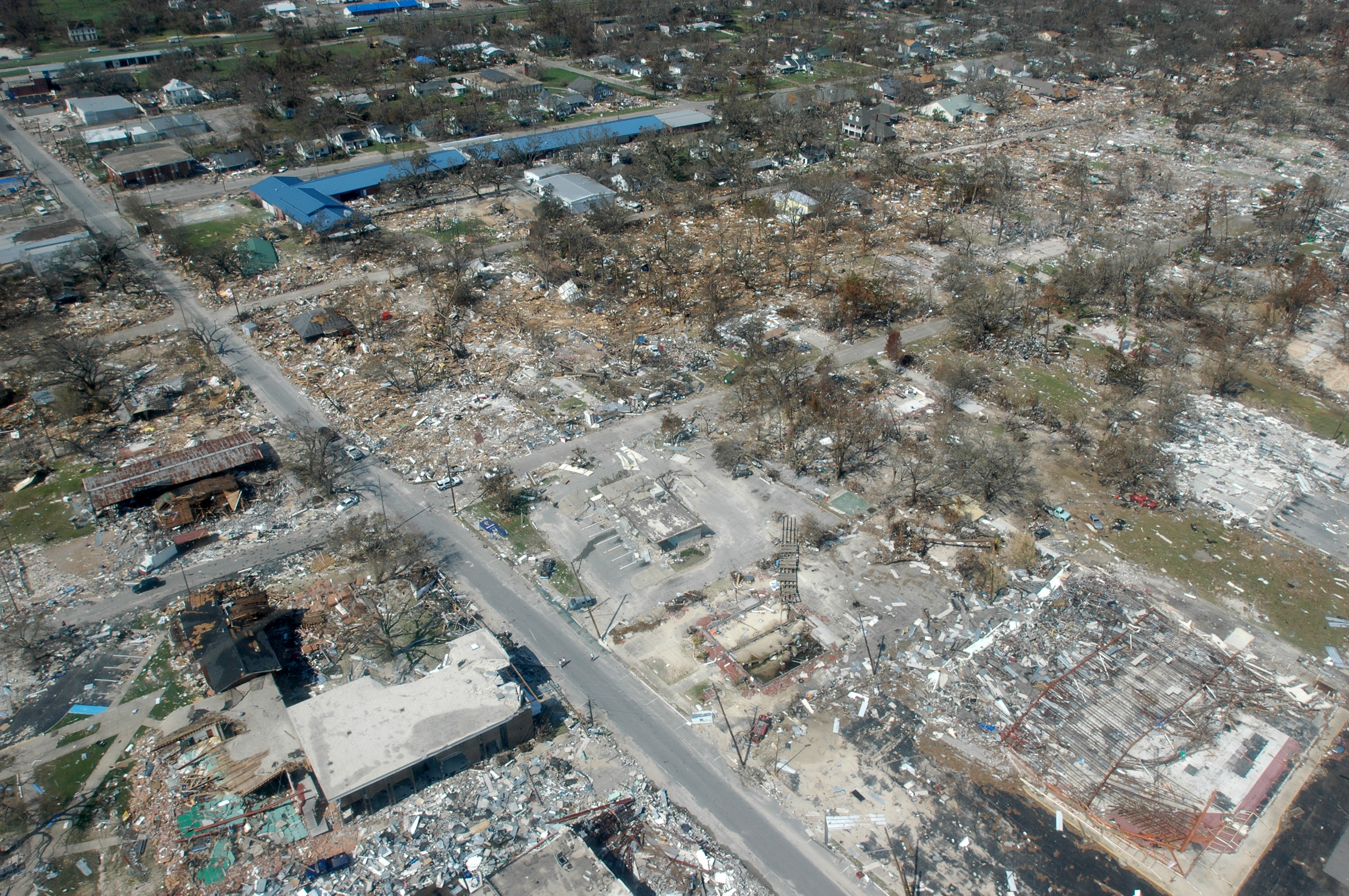
Long Beach, Mississippi, September 6, 2005 -- Destroyed businesses and municipal buildings on Jeff Davis Avenue in Long Beach, Mississippi from Hurricane Katrina (Long Beach is west of Gulfport and east of Pass Christian.) This photo shows the street at an angle but Jeff Davis actually runs North (upper left edge of the picture) to South (lower right) with the South part of the street at the photo's edge being approximately 200 yards from the Gulf of Mexico to approximately half-a-mile from the Gulf on the North end. The long, blue building is Harper McCaughan Elementary School, which appears to be shifted off of its foundation. To the north of that is Long Beach Public Library, with Long Beach City Hall to the north of the library. Although these building appear to be standing, upon closer inspection, they were heavily damaged and most had to be destroyed and re-built or re-located. The East-West streets showing are (going north) 5th Street, 4th St., and 3rd St. (the school and library intersection), 2nd St., then a little of the railroad tracks. There used to be as many houses on 4th and 5th streets as on 3rd St. and all the roads used to have a heavy cover of trees. The debris piles do not show very much in this photo because a lot of debris had been cleared from the area during the week between when the storm hit and this photo was taken, but the water-line debris piles created by the storm surge were at least 10-15 feet high in places (the debris line is more noticeable if you look at the roofs of the buildings.) Many of the businesses never came back but the City of Long Beach has done a very nice job of rebuilding the street much nicer than it was before.
The area in this photo is a fairly low-lying area. Hurricane Katrina caused extensive damage all along the Mississippi Gulf Coast with Waveland, Mississippi taking the strongest hit of the entire storm as it was right along the Northeast edge of the eye wall where the strongest winds of a hurricane reside.
From a long-time Beach resident... (edit by K. Dubuisson on 8/30/2011 not completed due to time constraint)
The section of Long Beach north of the railroad tracks is making a very speedy recovery, thanks to the diligence of City workers and all of the many volunteers in the area. The outpouring of support from all over the country has been incredible and greatly appreciated.
The section of Long Beach south of the tracks is a different story, although debris removal is coming along and a very few people have moved back into their homes. All (but one) of the people on Highway 90 lost their homes completely (gone with no trace), almost all on 5th and 4th streets have lost their homes completely, and most of the homes on 2nd and 3rd streets are heavily damaged, either by wind or by water. Most did not have flood insurance, except on Highway 90.
Some of us are having to get structural engineers to tell us whether or not it is feasible to repair our home or better to tear it down and start over. People have also hired structural engineers to try to prove that the wind took their home before the tidal surge brought all of the damaging water. If they can prove the wind took it, then their homeowner's insurance should pay. Otherwise ... FEMA is supposed to help with either low interest loans or grants. Most of us have not gone that far yet. Everything is still up-in-the-air (Oct 15, 2005), even after all of this time. (Volunteer structural engineers would be a blessing!)
Source
Photo courtesy FEMA/Mark Wolfe
This image is from the FEMA Photo Library (obsolete as of 2019).
An archived copy may be found at the Wayback Machine (note: link may be permanently dead, as not all photos were backed up in this way).
If the FEMA link is permanently dead, the photo can be found at NARA Access to Archival Databases (only works if photo was taken between 1989 and October 2004), or at City-data.com.
Licencim
| Public domainPublic domainfalsefalse |
This image is a work of a Federal Emergency Management Agency employee, taken or made as part of that person's official duties. As works of the U.S. federal government, all FEMA images are in the public domain in the United States. Additional media usage information may be found at https://www.fema.gov/photo-video-audio-use-guidelines
čeština ∙ English ∙ eesti ∙ italiano ∙ 日本語 ∙ македонски ∙ മലയാളം ∙ Nederlands ∙ polski ∙ sicilianu ∙ Türkçe ∙ українська ∙ 简体中文 ∙ 繁體中文 ∙ +/− |
Historiku skedës
Shtypni mbi një datë/kohë për ta parë skedën siç ishte atëherë.
| Data/Koha | Miniaturë | Përmasat | Përdoruesi | Koment | |
|---|---|---|---|---|---|
| e tanishme | 7 shtator 2005 05:42 | | 3.008 × 2.000 (2,64 MB) | Tom | {{PD-USGov}} http://www.photolibrary.fema.gov/photodata/original/14801.jpg Gulfport, Miss., September 6, 2005 -- Destroyed houses in Gulfport, Miss. Hurricane Katrina caused extensive damage all along the Mississippi gulf coast. New Orleans is being eva |
Lidhje skedash
Këto faqe lidhen tek kjo skedë:
Përdorimi global i skedës
Kjo skedë përdoret nga Wiki të tjera në vijim:
- Përdorimi në ar.wikipedia.org
- Përdorimi në ast.wikipedia.org
- Përdorimi në bn.wikipedia.org
- Përdorimi në de.wiktionary.org
- Përdorimi në el.wikipedia.org
- Përdorimi në en.wikipedia.org
- Geography of the United States
- Actuary
- Hurricane Katrina
- Wikipedia:Today's featured article/September 10, 2006
- Hurricane Katrina effects by region
- Effects of Hurricane Katrina in Mississippi
- Tropical cyclone preparedness
- Portal:Tropical cyclones
- Wikipedia:Today's featured article/September 2006
- Effects of tropical cyclones
- User:Alex1996Ne/Neat Pictures
- User:E. Brown/Hurricane Hall of Fame, continued
- List of costliest Atlantic hurricanes
- Portal:Business/Selected article
- Portal:Business/Selected article/6
- Përdorimi në en.wikiversity.org
- Përdorimi në es.wikipedia.org
- Përdorimi në es.wikinews.org
- Përdorimi në he.wikipedia.org
- Përdorimi në hi.wikipedia.org
- Përdorimi në hr.wikipedia.org
- Përdorimi në ia.wikipedia.org
- Përdorimi në id.wikipedia.org
- Përdorimi në it.wikipedia.org
- Përdorimi në ja.wikipedia.org
- Përdorimi në kk.wikipedia.org
- Përdorimi në kn.wikipedia.org
- Përdorimi në kw.wikipedia.org
- Përdorimi në li.wiktionary.org
- Përdorimi në lv.wikipedia.org
- Përdorimi në mn.wikipedia.org
- Përdorimi në ms.wikipedia.org
- Përdorimi në mwl.wikipedia.org
- Përdorimi në nl.wikibooks.org
- Përdorimi në nn.wikipedia.org
Shikoni më shumë përdorim global të kësaj skede.
Metadata
Kjo skedë përmban hollësira të tjera të cilat mund të jenë shtuar nga kamera ose skaneri dixhital që është përdorur për ta krijuar.
Në qoftë se skeda është ndryshuar nga gjendja origjinale, disa hollësira mund të mos pasqyrojnë versionin e tanishëm.
| Titulli i figurës | Gulfport, Miss., September 6, 2005 -- Destroyed houses in Gulfport, Miss. Hurricane Katrina caused extensive damage all along the Mississippi gulf coast. FEMA/Mark Wolfe |
|---|---|
| Prodhuesi i kamerës | NIKON CORPORATION |
| Modeli i kamerës | NIKON D70 |
| Autor | Mark Wolfe |
| Kohëzgjatja e ekspozimit | 1/400 sek (0,0025) |
| Numri F | f/10 |
| Data dhe koha e prodhimit të të dhënave | 6 shtator 2005 16:05 |
| Gjatësia e vatrës | 17 mm |
| Orientimi | Normale |
| Madhësia horizontale | 300 dpi |
| Madhësia vertikale | 300 dpi |
| Softueri i përdorur | Adobe Photoshop CS Windows |
| Data dhe ora e ndryshimit të skedës | 6 shtator 2005 17:55 |
| Pozicioni Y dhe C | Bashkë-Faqet |
| Zbuloni programin | Program normal |
| Versioni Exif-it | 2.21 |
| Data dhe ora e digjitalizimit | 6 shtator 2005 16:05 |
| Lloji i ngjeshjes së figurës | 4 |
| zbuloni vijat e pjerrëta | 0 |
| Hapje maksimale e tokës | 3 APEX (f/2,83) |
| Mënyra e matjes | Model |
| Burimi i dritës | I panjohur |
| Blici | Flashi nuk u ndez |
| Nën-sekondat DataKoha | 90 |
| Nën-sekondat DataKohaOrigjinale | 90 |
| Nën-sekondat DataKohaOrigjinale | 90 |
| Hapësira e ngjyrave | sRGB |
| Metoda Sensing | Zona e sensorit one-chip kolor |
| Përpunim i fotografisë Costum | Proces normal |
| Mënyra e ekspozimit | Ekspozim automatik |
| Balanca e bardhë | Balance e bardhe automatike |
| Zmadhim dixhital | 1 |
| Gjatësia fokale në 35 mm film | 25 mm |
| Shtrirja e largësisë | Standarte |
| Kontrasti | Normale |
| Mbushja | Normale |
| Ashpërsia | Normale |
| Shtrirja e largësisë së subjektit | E panjohur |