Ankara
From Wikipedia, the free encyclopedia
Ankara is the caipital o Turkey an the kintras's seicont maist muckle ceety efter Istanbul. The ceety haes a mean elevation o 938 metre abuin sea level, wi varyin elevations frae 900 metre tae 1,300 metre abuin sea level.[3] At 2008 the ceety haed 4,500,000 fowk. Ankara is the caipital o Ankara Province an aw.
Ankara | |
|---|---|
City | |
 | |
 Ankara Location o Ankara | |
| Coordinates: 39°52′N 32°52′E | |
| Kintra | Turkey |
| Region | Central Anatolie |
| Province | Ankara |
| Govrenment | |
| • Mayor | Mansur Yavaş [1] (CHP) |
| • Govrenor | Vasip Şahin |
| Area | |
| • City | 2516 km2 (971 sq mi) |
| Elevation | 938 m (3,077 ft) |
| Population (2010)[2] | |
| • Density | 1551/km2 (4,020/sq mi) |
| • Metro | 4,431,719 |
| Time zone | UTC+2 (EET) |
| • Summer (DST) | UTC+3 (EEST) |
| Postal code | 06xxx |
| Area code(s) | 312 |
| Licence plate | 06 |
| Website | http://www.ankara.bel.tr/ http://www.ankara.gov.tr/ |
As wi mony auncient cities, Ankara haes gaun bi twa-three name ower the ages. It haes been identified wi the Hittite cult center Ankuwaš,[4][5] awtho this is a maiter o debate.[6] In classical antiquity an durin the medieval period, the ceety wis kent as Ánkyra (Ἄγκυρα, "anchor") in Greek an Ancyra in Latin; the Galatian Celtic name wis mebbe a seemilar variant. Follaein its annexation bi the Seljuk Turks in 1073, the ceety became kent in mony European leids as Angora, a uisage thit continued until its offeecial renamin tae Ankara unner the Turkish Postal Service Law o 1930.[7]
Locatit in the centre in Anatolie, Ankara is an important commercial an industrial ceety. It is the centre for the Turkish Govrenment, an hooses aw foreign embassies. It is an important crossroads o tred, strategically locatit at the centre o Turkey's heichway an railwey netwirks, an serves as the mercatin centre for the surroondin agricultural area. The ceety wis famous for its lang-haired Angora goat an its prized wool (mohair), a unique breed o cat (Angora cat), white rabbits an thair prized wool (Angora wool), peirs, honey, an the region's muscat grapes.
The historical centre o Ankara is seetuatit on a rocky hill, thit rises 150 m (492 ft) abuin the plain on the left bank o the Ankara Çayı, a tributary o the Sakarya (Sangarius) river. The ceety is fund at 39°52'30" North, 32°52' East (39.875°N 32.8333°E), aboot 351 km (218 mi) tae the sootheast o Istanbul, the kintra's mucklest ceety. Awtho situatit in ane o the driest places in Turkey an surroondit maistly bi steppe vegetation except for the forestit areas on the soothren periphery, Ankara can be considered a green ceety in terms o green areas per inhabitant, that is 72 m2 per heid.[8]
Ankara is a verra auld ceety wi various Hittite, Phrygian, Hellenistic, Roman, Byzantine, an Ottoman archaeological sites. The hill thit owerleuks the ceety is crouned bi the ruins o the auld castle, thit adds tae the picturesque view, but anely twa-three historic structur surroondin the auld citadel hae survived tae the present day. Thare are, housomeivver, mony finely preserved remeens o Hellenistic, Roman an Byzantine architectur, the maist remairkable bein the Temple o Augustus an Roum (20 BC) thit is cried the Monumentum Ancyranum an aw.[9]
Internaitional relations
Twin touns — sister cities
Ankara is twinned wi:[10] o Ankara are leetit belaw:
Gallery
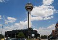 Atakule Touer an Atrium maw in central Ankara


.jpg)


References
Freemit airtins
Wikiwand - on
Seamless Wikipedia browsing. On steroids.