ഭൂമിയുടെ മദ്ധ്യപ്രദേശത്തുകൂടിയുള്ള സാങ്കൽപിക രേഖ From Wikipedia, the free encyclopedia
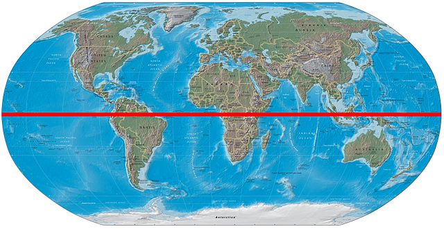
ഭൂമിയുടെ പ്രതലത്തിൽ, ദക്ഷിണധ്രുവത്തിൽനിന്നും ഉത്തരധ്രുവത്തിൽനിന്നും തുല്യ അകലത്തിലായി രേഖപ്പെടുത്താവുന്ന ഒരു സാങ്കൽപിക രേഖയാണ് ഭൂമദ്ധ്യരേഖ (ഇംഗ്ലീഷിൽ: Equator (ഇക്വേറ്റർ)). 00 അക്ഷാംശ രേഖയാണ് ഭൂമദ്ധ്യരേഖ. ഇത് ഭൂമിയെ ഉത്തരാർദ്ധവും ദക്ഷിണാർദ്ധവുമായി വിഭജിക്കുന്നു. മറ്റു ഗ്രഹങ്ങളുടെയും ആകാശവസ്തുക്കളുടെയും മദ്ധ്യരേഖകൾ സമാനമായ രീതിയിലാണ് നിർവചിക്കുന്നത്.40,075 കിലോമീറ്ററാണ് (24,901 മൈൽ) ഭൂമദ്ധ്യരേഖയുടെ ആകെ ദൈർഘ്യം. ഇതിന്റെ 78.7% കടലിലൂടെയും 21.3% കരയിലൂടെയും കടന്നുപോകുന്നു.


ഇക്വഡോർ എന്ന രാജ്യത്തിന് ആ പേര് വന്നത് ഭൂമദ്ധ്യരേഖ അതിലൂടെ കടന്നു പോകുന്നതിനാലാണ്. ഭൂമധ്യരേഖയുടെ സ്പാനിഷ് പേരാണ് ഇക്വഡോർ എന്നത്.
ഭൂമദ്ധ്യരേഖക്ക് സമാന്തരമായി ഉത്തരാർദ്ധഗോളത്തിലും ദക്ഷിണാർദ്ധഗോളത്തിലും രേഖപ്പെടുത്താവുന്ന രേഖകളെയാണ് അക്ഷാംശം എന്നു പറയുന്നത്.
14 രാജ്യങ്ങളിലൂടെ ഭൂമദ്ധ്യരേഖ കടന്നുപോകുന്നുണ്ട്. ഗ്രെനിച്ച് രേഖയിൽ നിന്നുതുടങ്ങി കിഴക്കോട്ട് എന്ന ക്രമത്തിലാണ് ഈ പട്ടികയിൽ രാജ്യങ്ങളെ ക്രമീകരിച്ചിരിക്കുന്നത്.
| Co-ordinates | രാജ്യം, ഭൂപ്രദേശം അല്ലെങ്കിൽ കടൽ | കുറിപ്പുകൾ |
|---|---|---|
| 0°N 0°E | Atlantic Ocean | Gulf of Guinea |
| 0°0′N 6°31′E | Ilhéu das Rolas | |
| 0°0′N 6°31′E | Atlantic Ocean | Gulf of Guinea |
| 0°0′N 9°21′E | ||
| 0°0′N 13°56′E | Passing through the town of Makoua. | |
| 0°0′N 17°46′E | Passing 9 km south of central Butembo | |
| 0°0′N 29°43′E | Passing 32 km south of central Kampala | |
| 0°0′N 32°22′E | Lake Victoria | Passing through some islands of |
| 0°0′N 34°0′E | Passing 6 km north of central Kisumu | |
| 0°0′N 41°0′E | ||
| 0°0′N 42°53′E | Indian Ocean | Passing between Huvadhu Atoll and Fuvahmulah of the |
| 0°0′N 98°12′E | The Batu Islands, Sumatra and the Lingga Islands | |
| 0°0′N 104°34′E | Karimata Strait | |
| 0°0′N 109°9′E | Borneo | |
| 0°0′N 117°30′E | Makassar Strait | |
| 0°0′N 119°40′E | Sulawesi (Celebes) | |
| 0°0′N 120°5′E | Gulf of Tomini | |
| 0°0′N 124°0′E | Molucca Sea | |
| 0°0′N 127°24′E | Kayoa and Halmahera islands | |
| 0°0′N 127°53′E | Halmahera Sea | |
| 0°0′N 129°20′E | Gebe Island | |
| 0°0′N 129°21′E | Pacific Ocean | Passing 570 m north of Waigeo island, Passing 13 km south of Aranuka atoll, Passing 21 km south of Baker Island, |
| 0°0′N 91°35′W | Isabela Island in the Galápagos Islands | |
| 0°0′N 91°13′W | Pacific Ocean | |
| 0°0′N 80°6′W | Passing 24 km north of central Quito, near Mitad del Mundo | |
| 0°0′N 75°32′W | Passing 4.3 km north of the border with Peru | |
| 0°0′N 70°3′W | Amazonas Roraima Amazonas Pará Amapá Pará - islands in the mouth of the Amazon River | |
| 0°0′N 49°20′W | Atlantic Ocean | |
Seamless Wikipedia browsing. On steroids.
Every time you click a link to Wikipedia, Wiktionary or Wikiquote in your browser's search results, it will show the modern Wikiwand interface.
Wikiwand extension is a five stars, simple, with minimum permission required to keep your browsing private, safe and transparent.