파일:Italy_1494_AD.png
From Wikipedia, the free encyclopedia

미리 보기 크기: 419 × 600 픽셀 다른 해상도: 168 × 240 픽셀 | 335 × 480 픽셀 | 536 × 768 픽셀 | 1,261 × 1,805 픽셀
원본 파일 (1,261 × 1,805 픽셀, 파일 크기: 144 KB, MIME 종류: image/png)
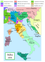
The factual accuracy of this map or the file name is disputed.
Reason: Do not use this map until SVG is corrected and PNG updated, as it is mostly based on the Shepherd's map which shows innacurate history of Venetian Republic on Eastern Adriatic, specifically of Dalmatia. It is showing seriouly erroneous and misleading Venetian control over whole region of modern Dalmatia - which became in full extent only in the late 17th and 18th century. It was never the case in the 15th and 16th century, as then most part of Dalmatian hinterland was under Hungarian-Croatian Kingdom and then Ottoman Empire. Venetian Dalmatia at the time included only the very coastal part of Dalmatia with very near hinterland of the Dalmatian city-states, the majority of the hinterland was not Venetian at all. The borders of the Ottoman conquest are also significantly erroneous for the time period as in the map look like modern borders of Bosnia and Herzegovina which became the case only many centuries later.
The map omits a lot of Venice, both islands such as Crete, and coastal areas such as Kotor. |  |

|
이 그림은 벡터 그래픽 버전(SVG)이 있습니다. 래스터(비트맵) 그림 대신 벡터 그래픽 그림을 사용하는 것이 좋습니다.
File:Italy 1494 AD.png → File:Italy 1494 AD-it.svg
|
 |
파일 설명
Political map of Italy in early 1494, before the invasion of Italy by Charles VIII of France, created by MapMaster.
Part of a series of maps on the history of Italy:
-
 1000 AD
 -
 1084 AD
 -
 1796 AD
 -
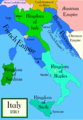 1810 AD


Versions
[편집]
PNG:
-
 아랍어
아랍어 -
 영어
영어 -
 그리스어
그리스어


SVG:
-
 카탈로니아어
 -
 스페인어
스페인어 -
 프랑스어
프랑스어 -
 이탈리아어
이탈리아어 -
 헝가리어
헝가리어


See similar versions (disputed too): Map of Italy (1494)
References
- Bjorklund, Oddvar; Holmboe, Haakon; Rohr, Anders (1970) Historical Atlas of the World, Barnes & Noble, NY, SBN: 389-00253-4.
- Matthew, Donald, (1983), Atlas of Medieval Europe, Checkmark Books, New York.
- Online maps, including this 1882 map from Shepherd (the University of Texas)
- this one from A B Longman, textbook publisher.
라이선스
나는 아래 작품의 저작권자로서, 이 저작물을 다음과 같은 라이선스로 배포합니다:

|
GNU 자유 문서 사용 허가서 1.2판 또는 자유 소프트웨어 재단에서 발행한 이후 판의 규정에 따라 본 문서를 복제하거나 개작 및 배포할 수 있습니다. 본 문서에는 변경 불가 부분이 없으며, 앞 표지 구절과 뒷 표지 구절도 없습니다. 본 사용 허가서의 전체 내용은 GNU 자유 문서 사용 허가서 부분에 포함되어 있습니다.http://www.gnu.org/copyleft/fdl.htmlGFDLGNU Free Documentation Licensetruetrue |
| 이 파일은 크리에이티브 커먼즈 저작자표시-동일조건변경허락 3.0 Unported 라이선스로 배포됩니다. | ||
| ||
| 이 라이선스 틀은 GFDL 라이선스 변경의 일부로 이 파일에 추가되었습니다.http://creativecommons.org/licenses/by-sa/3.0/CC BY-SA 3.0Creative Commons Attribution-Share Alike 3.0truetrue |
이 라이선스 중에서 목적에 맞는 것을 선택하여 사용할 수 있습니다.
derivative works
이 파일은 다음으로 파생됨: Italy 1494 AD-ar.png
설명
이 파일이 나타내는 바에 대한 한 줄 설명을 추가합니다
A political map of the Italian Peninsula circa 1494
파일 역사
날짜/시간 링크를 클릭하면 해당 시간의 파일을 볼 수 있습니다.
| 날짜/시간 | 섬네일 | 크기 | 사용자 | 설명 | |
|---|---|---|---|---|---|
| 현재 | 2009년 4월 21일 (화) 10:15 | | 1,261 × 1,805 (144 KB) | Capmo | palette reduction to 256 colours |
| 2007년 4월 15일 (일) 07:04 |  | 1,261 × 1,805 (539 KB) | MapMaster | Minor modifications | |
| 2007년 2월 28일 (수) 01:07 |  | 1,167 × 1,642 (471 KB) | MapMaster | Modification suggested by User:Paolo da Reggio | |
| 2007년 1월 9일 (화) 08:52 |  | 1,135 × 1,625 (472 KB) | MapMaster | Political map of Italy in early 1494, before the invasion of Italy by Charles VIII of France, created by MapMaster. |
이 파일을 사용하는 문서
이 파일을 사용하고 있는 모든 위키의 문서 목록
다음 위키에서 이 파일을 사용하고 있습니다:
- af.wikipedia.org에서 이 파일을 사용하고 있는 문서 목록
- azb.wikipedia.org에서 이 파일을 사용하고 있는 문서 목록
- az.wikipedia.org에서 이 파일을 사용하고 있는 문서 목록
- bg.wikipedia.org에서 이 파일을 사용하고 있는 문서 목록
- br.wikipedia.org에서 이 파일을 사용하고 있는 문서 목록
- bxr.wikipedia.org에서 이 파일을 사용하고 있는 문서 목록
- cs.wikipedia.org에서 이 파일을 사용하고 있는 문서 목록
- de.wikipedia.org에서 이 파일을 사용하고 있는 문서 목록
- el.wikipedia.org에서 이 파일을 사용하고 있는 문서 목록
- en.wikipedia.org에서 이 파일을 사용하고 있는 문서 목록
- Pope Alexander VI
- Renaissance
- Italian Wars
- Gonzalo Fernández de Córdoba
- Duke of Ferrara and of Modena
- Italian War of 1494–1495
- List of rulers of Montferrat
- User:MapMaster
- Military history of Italy
- User:Juanpdp/Italy
- User:Bolonium/Renaissance
- Marquisate of Incisa
- Timeline of Niccolò Machiavelli
- Italic League
- User:Falcaorib/Italy
- eo.wikipedia.org에서 이 파일을 사용하고 있는 문서 목록
- es.wikipedia.org에서 이 파일을 사용하고 있는 문서 목록
- et.wikipedia.org에서 이 파일을 사용하고 있는 문서 목록
- fa.wikipedia.org에서 이 파일을 사용하고 있는 문서 목록
- fr.wikipedia.org에서 이 파일을 사용하고 있는 문서 목록
이 파일의 더 많은 사용 내역을 봅니다.
메타데이터
이 파일에는 카메라나 스캐너가 파일을 만들거나 디지털화하는 데 사용하기 위해 기록한 부가 정보가 포함되어 있습니다.
프로그램에서 파일을 편집한 경우, 새로 저장한 파일에 일부 부가 정보가 빠질 수 있습니다.
| 수평 해상도 | 78.74 dpc |
|---|---|
| 수직 해상도 | 78.74 dpc |