Фин шығанағы
From Wikipedia, the free encyclopedia

From Wikipedia, the free encyclopedia
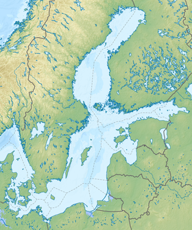
Финн шығанағы (фин. Suomenlahti, эст. Soome laht, швед. Finska viken) — Балтық теңізінің шығыс бөлігіндегі шығанақ. Финляндия, Ресей және Эстония жағалауларын жуады. Шығанақтың батыстағы шекарасы Ханко түбегі мен Пыызаспеа мүйісінің (Осмуссаар аралы) аралығындағы шартты сызық болып есептеледі[1][2].59°53′ с. е. 26°06′ ш. б.59.883° с. е. 26.100° ш. б. (G) (O) (Я)
| Фин шығанағы фин. Suomenlahti, эст. Soome laht, швед. Finska viken, орыс. Финский залив | |
 | |
| Сипаттамасы | |
|---|---|
| Түрі | шығанақ |
| Ауданы | 29 500 км² |
| Тереңдігі | 121 м |
| Орташа тереңдігі | 38 м |
| Тұздылығы | 0,2-9,2 ‰ |
| Суды жинау ауданы | 420 000 км² |
| Орналасуы | |
| 59°53′00″ с. е. 26°06′00″ ш. б.59.8833° с. е. 26.1° ш. б. (G) (O) (Я) | |
| Өзінен жоғары акватория | Балтық теңізі |
| Елдер | |
Ауданы 30 мың км2. Ұзындығы 420 км, кіре берістегі ені 70 км. Тереңдігі 100 м-ге дейін барады. Солтүстік жағасы жартасты, күшті тілімделген, аралдары көп. Шығыс және оңтүстік жағасының көп бөлігі жазық. Финн шығанағының шығыс бөлігіндегі Нева кірмесіне Нева өзені құяды; солтүстікке таман Выборг шығанағы, оңтүстікте Копорье және [[Нарва[[ шығанақтары және Луга кірмесі орналасқан. Қарашадан сәуірге дейін мұз қаьады. Су деңгей желдің әсеріне байланысты жиі өзгеріп отырады. [3]
 |
 |
 |
 |
| Санкт-Петербург қаласындағы үлкен кемежай | Таллин порты | Хельсинки | Кронштадт айлағы |
Seamless Wikipedia browsing. On steroids.
Every time you click a link to Wikipedia, Wiktionary or Wikiquote in your browser's search results, it will show the modern Wikiwand interface.
Wikiwand extension is a five stars, simple, with minimum permission required to keep your browsing private, safe and transparent.