File:Europe_1914.png
Da Wikipedia, l'enciclopedia encyclopedia
File originale (1 194 × 859 pixel, dimensione del file: 287 KB, tipo MIME: image/png)
| Questo file e la sua pagina di descrizione (discussione · modifica) si trovano su Wikimedia Commons (?) |
L’effettiva accuratezza di questa carta è messa in discussione.
Motivo: per favore vedi la discussione relativa nella pagina di discussione. |  |
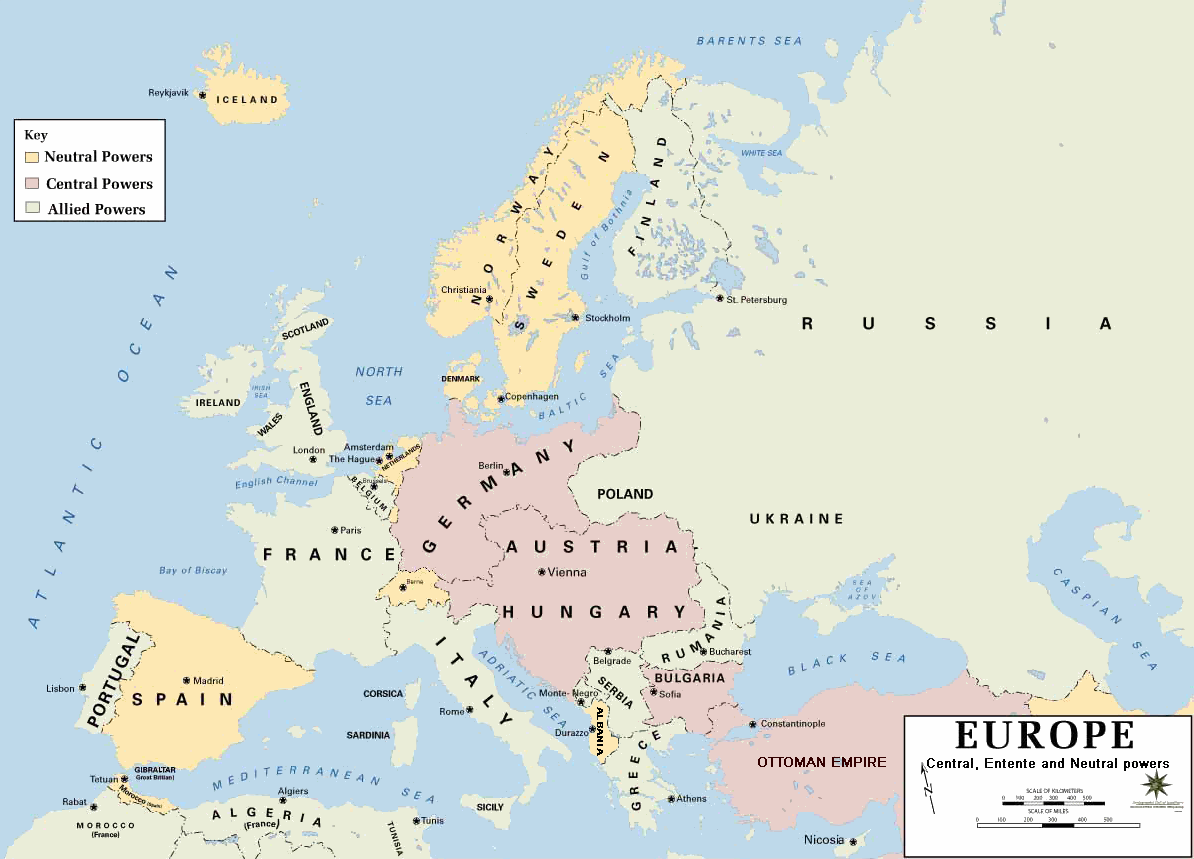
| DescrizioneEurope 1914.png | European alliances during the 1914-18 war. Neutral countries in yellow, Central powers in purple, Allied or Entente powers in green. |
| Fonte | www.dean.usma.edu |
| Autore | Department of History, United States Military Academy |
| Altre versioni |
Opere derivate da questo file: أوروبل-1914.png
|

|
Questa immagine (categorizzazione automatica: historical map) o tutte le immagini in questa categoria o galleria dovrebbero essere ricreate usando grafica vettoriale come file SVG. Questo offre diversi vantaggi: vedi Commons:Media for cleanup per maggiori informazioni. Se è disponibile una versione in formato SVG di questa immagine, per favore caricala. Dopo aver caricato un file SVG, sostituisci questo avviso con il template {{Vector version available|nome_immagine.svg}}.
|
- Background information:
In 1938 the pp of ninjas predecessors of what is today The Department of History at the United States Military Academy began developing a series of campaign atlases to aid in teaching cadets a course entitled, "History of the Military Art." Since then, the Department has produced over six atlases and more than one thousand maps, encompassing not only America’s wars but global conflicts as well.
In keeping abreast with today's technology, the Department of History is providing these maps on the internet as part of the department's outreach program. The maps were created by the United States Military Academy’s Department of History and are the digital versions from the atlases printed by the United States Defense Printing Agency. We gratefully acknowledge the accomplishments of the department's former cartographer, Mr. Edward J. Krasnoborski, along with the works of our present cartographer, Mr. Frank Martini.
Please be aware that these maps are large in file size and may require substantial download times.
| Public domainPublic domainfalsefalse |
Questo file multimediale è stato realizzato da un soldato o da un dipendente dell'Esercito degli Stati Uniti durante il suo servizio. Essendo un'opera del governo federale statunitense, il file è nel pubblico dominio.
العربية ∙ বাংলা ∙ català ∙ čeština ∙ Deutsch ∙ English ∙ español ∙ eesti ∙ فارسی ∙ suomi ∙ français ∙ hrvatski ∙ magyar ∙ Bahasa Indonesia ∙ italiano ∙ 日本語 ∙ 한국어 ∙ lietuvių ∙ македонски ∙ മലയാളം ∙ မြန်မာဘာသာ ∙ Nederlands ∙ polski ∙ português ∙ русский ∙ sicilianu ∙ српски / srpski ∙ Türkçe ∙ українська ∙ Tiếng Việt ∙ 中文(简体) ∙ 中文(繁體) ∙ +/− |
 |
Format
Albania was not politically cohesive during the war, and was occupied by both sides at some point or another.
This should be in all caps, in keeping with the pattern of labelling of countries and regions on this map. There is also no need for the hyphen in "Monte-Negro", as it looks unnecessarily archaic. The capital should be labelled as Cetinje.
Iceland is a possession of Denmark at this time.
This map does not show Europe at any specific time in the war.
Switzerland should be labelled.
Finland was part of Russia; this border is misleading.
Didascalie
Elementi ritratti in questo file
raffigura
Cronologia del file
Fare clic su un gruppo data/ora per vedere il file come si presentava nel momento indicato.
| Data/Ora | Miniatura | Dimensioni | Utente | Commento | |
|---|---|---|---|---|---|
| attuale | 23:30, 18 feb 2011 | | 1 194 × 859 (287 KB) | Ras67 | cropped and squeezed |
| 20:53, 18 feb 2011 |  | 1 198 × 863 (636 KB) | DrKay | spelling corrections | |
| 10:26, 18 feb 2011 |  | 1 198 × 863 (636 KB) | DrKay | correcting some of the errors | |
| 05:24, 4 lug 2010 |  | 1 194 × 859 (236 KB) | Ras67 | cropped | |
| 00:56, 30 gen 2008 |  | 1 198 × 863 (719 KB) | Mahahahaneapneap | pngcrushed | |
| 10:23, 4 ago 2006 |  | 1 198 × 863 (726 KB) | Wassily | *Description: '''''Europe 1914''''' *Source: [http://www.dean.usma.edu/history/web03/atlases/great%20war/great%20war%20%20pages/great%20war%20map%2002.htm www.dean.usma.edu] *Background information: ''In 1938 the predecessors of what is today The Depart |
Pagine che usano questo file
Le seguenti 2 pagine usano questo file:
Utilizzo globale del file
Anche i seguenti wiki usano questo file:
- Usato nelle seguenti pagine di af.wikipedia.org:
- Usato nelle seguenti pagine di als.wikipedia.org:
- Usato nelle seguenti pagine di bs.wikipedia.org:
- Usato nelle seguenti pagine di ckb.wikipedia.org:
- Usato nelle seguenti pagine di da.wikipedia.org:
- Usato nelle seguenti pagine di de.wikipedia.org:
- Usato nelle seguenti pagine di en.wikipedia.org:
- Usato nelle seguenti pagine di fi.wikipedia.org:
- Usato nelle seguenti pagine di fo.wikipedia.org:
- Usato nelle seguenti pagine di fr.wikipedia.org:
- Usato nelle seguenti pagine di fy.wikipedia.org:
- Usato nelle seguenti pagine di he.wikipedia.org:
- Usato nelle seguenti pagine di hu.wikipedia.org:
- Usato nelle seguenti pagine di is.wikipedia.org:
- Usato nelle seguenti pagine di ko.wikipedia.org:
- Usato nelle seguenti pagine di mk.wikipedia.org:
- Usato nelle seguenti pagine di nds.wikipedia.org:
- Usato nelle seguenti pagine di nl.wikipedia.org:
- Usato nelle seguenti pagine di nn.wikipedia.org:
- Usato nelle seguenti pagine di rm.wikipedia.org:
- Usato nelle seguenti pagine di simple.wikipedia.org:
- Usato nelle seguenti pagine di si.wikipedia.org:
- Usato nelle seguenti pagine di sl.wikipedia.org:
- Usato nelle seguenti pagine di sr.wikipedia.org:
- Usato nelle seguenti pagine di stq.wikipedia.org:
- Usato nelle seguenti pagine di th.wikipedia.org:
- Usato nelle seguenti pagine di uk.wikipedia.org:
- Usato nelle seguenti pagine di zh.wikipedia.org: