Berkas:Italy_1494_AD.png
From Wikipedia, the free encyclopedia

Ukuran asli (1.261 × 1.805 piksel, ukuran berkas: 144 KB, tipe MIME: image/png)
Berkas ini berasal dari Wikimedia Commons dan mungkin digunakan oleh proyek-proyek lain. Deskripsi dari halaman deskripsinya ditunjukkan di bawah ini.
Akurasi fakta dalam peta atau nama berkas ini diperdebatkan.
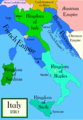
Alasan: Do not use this map until SVG is corrected and PNG updated, as it is mostly based on the Shepherd's map which shows innacurate history of Venetian Republic on Eastern Adriatic, specifically of Dalmatia. It is showing seriouly erroneous and misleading Venetian control over whole region of modern Dalmatia - which became in full extent only in the late 17th and 18th century. It was never the case in the 15th and 16th century, as then most part of Dalmatian hinterland was under Hungarian-Croatian Kingdom and then Ottoman Empire. Venetian Dalmatia at the time included only the very coastal part of Dalmatia with very near hinterland of the Dalmatian city-states, the majority of the hinterland was not Venetian at all. The borders of the Ottoman conquest are also significantly erroneous for the time period as in the map look like modern borders of Bosnia and Herzegovina which became the case only many centuries later.
The map omits a lot of Venice, both islands such as Crete, and coastal areas such as Kotor. |  |

|
File:Italy 1494 AD-it.svg merupakan versi vektor dari berkas ini. Berkas itu harus digunakan menggantikan gambar raster ini jika kualitasnya tidak rendah.
File:Italy 1494 AD.png → File:Italy 1494 AD-it.svg
Untuk informasi lanjutan, lihat Bantuan:SVG.
|
 |
Daftar isi
Ringkasan
Political map of Italy in early 1494, before the invasion of Italy by Charles VIII of France, created by MapMaster.
Part of a series of maps on the history of Italy:
-
 1000 AD
 -
 1084 AD
 -
 1796 AD
 -
 1810 AD


Versions
[sunting]
PNG:
-
 Arab
Arab -
 Inggris
 -
 Yunani


SVG:
-
 Katalan
 -
 Spanyol
 -
 Prancis
 -
 Italia
 -
 Hungaria


See similar versions (disputed too): Map of Italy (1494)
References
- Bjorklund, Oddvar; Holmboe, Haakon; Rohr, Anders (1970) Historical Atlas of the World, Barnes & Noble, NY, SBN: 389-00253-4.
- Matthew, Donald, (1983), Atlas of Medieval Europe, Checkmark Books, New York.
- Online maps, including this 1882 map from Shepherd (the University of Texas)
- this one from A B Longman, textbook publisher.
Lisensi

|
Diizinkan untuk menyalin, mendistribusikan dan/atau memodifikasi dokumen ini di bawah syarat-syarat Lisensi Dokumentasi Bebas GNU, Versi 1.2 atau lebih baru yang diterbitkan oleh Free Software Foundation; tanpa Bagian Invarian, tanpa Teks Sampul Depan, dan tanpa Teks Sampul Belakang. Salinan lisensi dimasukkan ke bagian yang berjudul Lisensi Dokumentasi Bebas GNU.http://www.gnu.org/copyleft/fdl.htmlGFDLGNU Free Documentation Licensetruetrue |
| Berkas on ipartandoan sian on Creative Commons Attribution-Share Alike 3.0 Unported partadoan. | ||
| ||
| Label lisensi ini ditambahkan pada berkas sebagai bagian dari pemutakhiran lisensi GFDL.http://creativecommons.org/licenses/by-sa/3.0/CC BY-SA 3.0Creative Commons Attribution-Share Alike 3.0truetrue |
derivative works
Karya turunan dari berkas ini: Italy 1494 AD-ar.png
Captions
Items portrayed in this file
menggambarkan
Riwayat berkas
Klik pada tanggal/waktu untuk melihat berkas ini pada saat tersebut.
| Tanggal/Waktu | Miniatur | Dimensi | Pengguna | Komentar | |
|---|---|---|---|---|---|
| terkini | 21 April 2009 01.15 | | 1.261 × 1.805 (144 KB) | Capmo | palette reduction to 256 colours |
| 14 April 2007 22.04 |  | 1.261 × 1.805 (539 KB) | MapMaster | Minor modifications | |
| 27 Februari 2007 16.07 |  | 1.167 × 1.642 (471 KB) | MapMaster | Modification suggested by User:Paolo da Reggio | |
| 8 Januari 2007 23.52 |  | 1.135 × 1.625 (472 KB) | MapMaster | Political map of Italy in early 1494, before the invasion of Italy by Charles VIII of France, created by MapMaster. |
Penggunaan berkas
Halaman berikut menggunakan berkas ini:
Penggunaan berkas global
Wiki lain berikut menggunakan berkas ini:
- Penggunaan pada af.wikipedia.org
- Penggunaan pada azb.wikipedia.org
- Penggunaan pada az.wikipedia.org
- Penggunaan pada bg.wikipedia.org
- Penggunaan pada br.wikipedia.org
- Penggunaan pada bxr.wikipedia.org
- Penggunaan pada cs.wikipedia.org
- Penggunaan pada de.wikipedia.org
- Penggunaan pada el.wikipedia.org
- Penggunaan pada en.wikipedia.org
- Pope Alexander VI
- Renaissance
- Italian Wars
- Gonzalo Fernández de Córdoba
- Duke of Ferrara and of Modena
- Italian War of 1494–1495
- List of rulers of Montferrat
- User:MapMaster
- Military history of Italy
- User:Juanpdp/Italy
- User:Bolonium/Renaissance
- Marquisate of Incisa
- Timeline of Niccolò Machiavelli
- Italic League
- User:Falcaorib/Italy
- Penggunaan pada eo.wikipedia.org
- Penggunaan pada es.wikipedia.org
- Penggunaan pada et.wikipedia.org
- Penggunaan pada fa.wikipedia.org
- Penggunaan pada fr.wikipedia.org
Lihat lebih banyak penggunaan global dari berkas ini.
Metadata
Berkas ini mengandung informasi tambahan yang mungkin ditambahkan oleh kamera digital atau pemindai yang digunakan untuk membuat atau mendigitalisasi berkas. Jika berkas ini telah mengalami modifikasi, rincian yang ada mungkin tidak secara penuh merefleksikan informasi dari gambar yang sudah dimodifikasi ini.
| Resolusi horizontal | 78,74 dpc |
|---|---|
| Resolusi vertikal | 78,74 dpc |