Sikhism in Pakistan
Overview of the role and impact of Sikhism in Pakistan From Wikipedia, the free encyclopedia

Sikhism is the fourth largest religion in Pakistan with a population of more than 15,000 Sikhs, mostly residing in Punjab and Khyber Pakhtunkhwa, accounting for 0.01% of the country's population. Sikhism has an extensive heritage and history in the country, although Sikhs form a very small community in Pakistan today. Sikhism originated from what is now Punjab, Pakistan in the 15th century. Nankana Sahib, the birthplace of Guru Nanak, is located in Pakistan's Punjab province. Moreover, the place where Guru Nanak died, the Gurudwara Kartarpur Sahib is also located in the same province.
.svg) | |
| |
| Total population | |
|---|---|
| 15,998 (2023 census)[1] | |
| Regions with significant populations | |
| Punjab | 5,649 |
| Sindh | 5,182 |
| Khyber Pakhtunkhwa | 4,050 |
| Balochistan | 1,057 |
| Languages | |
| Punjabi • Urdu • Pashto • Sindhi • Balochi • Pakistani English | |
In the 18th and 19th centuries, the Sikh community became a major political power in Punjab, with Sikh leader Maharaja Ranjit Singh founding the Sikh Empire which had its capital in Lahore, the second-largest city in Pakistan today.[2][3]
According to the 1941 census, the Sikh population comprised roughly 1.67 million persons or 6.1 percent of the total population in the region that would ultimately become Pakistan,[a] notably concentrated in West Punjab, within the contemporary province of Punjab, Pakistan, where the Sikh population stood at roughly 1.52 million persons or 8.8 percent of the total population.[b]
By 1947, it is estimated that the Sikh population increased to over 2 million persons in the region which became Pakistan with significant populations existing in the largest cities in the Punjab such as Lahore, Rawalpindi and Faisalabad (then Lyallpur), however with violence and religious cleansing accompanying the partition of India at the time, the vast majority departed the region en masse, primarily migrating eastward to the region of Punjab that would fall on the eastern side of the Radcliffe Line, in the contemporary Indian states of Punjab, Haryana, Himachal Pradesh, and Delhi.[4][5]
In the decades following Pakistan's formation in 1947, the remaining Sikh community began to re-organize, forming the Pakistan Sikh Gurdwara Prabandhak Committee (PSGPC) to represent the community and protect the holy sites and heritage of the Sikh religion in Pakistan. It is headed by Satwant Singh.[6] The Pakistani government has begun to allow Sikhs from India to make pilgrimages to Sikh places of worship in Pakistan and for Pakistani Sikhs to travel to India.
History
Summarize
Perspective
Colonial era


Prior to independence in 1947, 2 million Sikhs resided in the present day Pakistan and were spread all across Northern Pakistan, specifically the Punjab region and played an important role in its economy as farmers, businessmen, and traders. Significant populations of Sikhs inhabited the largest cities in the Punjab such as Lahore, Rawalpindi and Lyallpur.
Lahore, the capital of Punjab, was then and still is today the location of many important Sikh religious and historical sites, including the Samadhi of Maharaja Ranjit Singh, who is referred to as Sher-e-Punjab .The nearby town of Nankana Sahib has nine Gurudwaras, and is the birthplace of Sikhism's founder, Guru Nanak Sahib. Each of Nankana Sahib's gurdwaras are associated with different events in Guru Nanak Dev's life. The town remains an important site of pilgrimage for Sikhs worldwide.
Sikh organizations, including the Chief Khalsa Dewan and Shiromani Akali Dal led by Master Tara Singh, condemned the Lahore Resolution and the movement to create Pakistan, viewing it as welcoming possible persecution; the Sikhs largely thus strongly opposed the partition of India.[7]
Partition of India (1947)

The majority of the Sikhs and Hindus of West Punjab and Sindh provinces of Pakistan migrated to India after the independence of Pakistan in 1947, resulting in a fraction of the Sikh communities that formerly existed previously. These Sikh and Hindu refugee communities have had a major influence in the culture and economics of the Indian capital city of Delhi. Today, segments of the populations of East Punjab and Haryana states and Delhi in India can trace their ancestry back to towns and villages now in Pakistan, including former Indian Prime Minister Manmohan Singh.[8][9]
Modern era
Sikhs have mainly kept a low profile within the monolithic Muslim population of Pakistan.[10] Though, Pakistan maintains the title of Islamic state, the articles twenty, twenty-one and twenty-two in chapter two of its constitution guarantees religious freedom to the non-Muslim residents.[11] Since independence in 1947, relations between Pakistan's minorities and the Muslim majority have remained fairly and politically stable.
From 1984 to 2002, Pakistan held a system of separate electorates for all its national legislative assemblies, with only a handful of parliamentary seats reserved for minority members. Minorities were legally only permitted to vote for designated minority candidates in general elections.
The regime of former President General Pervez Musharraf had professed an agenda of equality for minorities and promotion and protection of minority rights, however, the implementation of corrective measures has been slow. Considerable amount of Sikhs are found in neighbourhood called Narayanpura of Karachi's Ranchore Lines.[12][13]
The historical and holy sites of Sikhs are maintained by a Pakistani governmental body, the Pakistan Sikh Gurdwara Prabandhak Committee, which is responsible for their upkeep and preservation.
The emergence of the Sikh community within Pakistan

After the independence of Pakistan and the migration of nearly all Sikhs to India the Sikh community's rights were significantly diminished as their population decreased.[14] Today, the largest urban Sikh population in Pakistan is found in Peshawar, in the Khyber-Pakhtunkhwa, where the Pashtun law of "nanawati" (protection) spared the scale of violence which had raged across the Indus River in Punjab. Despite the longstanding tensions between the Sikh and Muslim communities in South Asia, the Pashtuns were tolerant towards the religious minority of Sikhs.[15] There are small pockets of Sikhs in Lahore and Nankana Sahib in Punjab.
There has been an influx of Sikh refugees from Afghanistan to Pakistan due to the turbulent civil war and conflicts that have ravaged neighboring Afghanistan, and many of these Sikhs have settled in Peshawar.[16] Afghanistan, like Pakistan, has had small Sikh and Hindu populations. There has been a massive exodus of refugees from Afghanistan into Pakistan during the past 30 years of turmoil up to the reign of the Taliban and the subsequent US invasion of Afghanistan in late 2001. Due to Pakistan's porous borders with Afghanistan, large numbers of Afghanistan's minority communities, based mainly around the cities of Kabul, Kandahar, and Jalalabad have fled, and some Sikhs have joined their kinsmen in Peshawar and Lahore.[17][18]
The Pakistani Constitution states that Sikhism is a monotheistic religion. Recently the Sikh community within Pakistan has been making every effort possible to progress in Pakistan. For example, Hercharn Singh became the first Sikh to join the Pakistan Army. For the first time in the 58-year history of Pakistan there has a Sikh been selected into Pakistan's army. Prior to Harcharan Singh's selection in the Pakistani army no individual person who was a member of the Hindu or the Sikh community were ever enrolled in the army, however; the Pakistani Christian community has prominently served in the Pakistan Armed Forces and some had even reached the ranks of Major Generals in the army, Air Vice Marshals in the Pakistan Air Force and rear Admiral in the Pakistan Navy. It has received various awards for gallantry and valor. Moreover, members of the tiny Parsi community have some representation in the Armed Forces.[19] Other prominent Sikhs are Inspector Amarjeet Singh of Pakistan Rangers and Lance-naik Behram Singh of Pakistan Coast Guard.[20]
In 2007, the Pakistan Government enacted the Sikh marriage act that allows Sikh marriages in Pakistan be registered.[21][22] In 2017, the Punjab legislative assembly passed the Anand Karaj act thereby allowing the Sikh marriage in Punjab province be registered.[23] In the Sindh province, the Sikh marriages are registered under the Sindh Hindu Marriage Act of 2016.[24]
Demographics
Summarize
Perspective
| Year | Pop. | ±% p.a. |
|---|---|---|
| 1901 | 529,910 | — |
| 1911 | 884,987 | +5.26% |
| 1921 | 931,489 | +0.51% |
| 1931 | 1,282,698 | +3.25% |
| 1941 | 1,672,753 | +2.69% |
| 1951 | 1,476 | −50.50% |
| 1981 | 2,146 | +1.26% |
| 1990 | 2,898 | +3.39% |
| 1993 | 3,374 | +5.20% |
| 2023 | 15,998 | +5.32% |
| Source: [c][d][e][f][a][g][25][26][27][28][29][1] Census of India, Census of Pakistan | ||
Decadal censuses taken in British India revealed the religious composition of all administrative divisions that would ultimately compose regions situated in contemporary Pakistan. The 1901 Census in British India taken in administrative divisions that would ultimately compose regions situated in contemporary Pakistan indicated that Sikhs numbered approximately 529,910 persons and comprised roughly 3.0 percent of the total population,[c] followed by an increase to around 884,987 persons or to 4.7 percent in 1911.[d] The Sikh population would rise to approximately 931,489 persons in 1921 with the share of the total population rising to 4.8 percent,[d] further increasing to 5.7 percent in 1931, with total Sikh population growing to roughly 1,282,698 persons.[f]
According to the Government of Pakistan's National Database and Registration Authority, there were 6,146 Sikhs registered in Pakistan in 2012.[30] A 2010 survey by the Sikh Resource and Study Centre reported 50,000 Sikhs living in Pakistan.[31] Most are settled in Khyber Pakhtunkhwa followed by Sindh and Punjab.[32] Other sources, including the US Department of State, claim the Sikh population in Pakistan to be as high as 20,000.[33][34] In a news article published in December 2022, there was an estimated 30,000–35,000 Sikhs in Pakistan according to Gurpal Singh and Sikhs will be included as a separate category and enumerated on the 2023 Census of Pakistan.[35] The results of the 2023 census will be a milestone in the first official inclusion of Sikhs since the formation of Pakistan as a sovereign nation. The National Database and Registration Authority (NADRA) has provided the numbers of eligible voters belonging to minority religions (registered in electoral rolls):
1901 census
According to the 1901 census, the Sikh population in Pakistan comprised roughly 529,910 persons or 3.0 percent of the total population.[c] With the exception of the Federally Administered Tribal Areas, all administrative divisions in the region that composes contemporary Pakistan collected religious data, with a combined population of 17,633,258, for an overall response rate of 99.6 percent out of the total population of 17,708,014, as detailed in the table below.[c]
| Administrative division |
1901 census | |||
|---|---|---|---|---|
| Sikh Population | Sikh Percentage | Total Responses | Total Population | |
| Punjab[37][38][h] | 483,999 | 4.64% | 10,427,765 | 10,427,765 |
| Khyber Pakhtunkhwa[39] | 25,733 | 1.25% | 2,050,724[i] | 2,125,480[i] |
| AJK[40][j] | 17,132 | 1.96% | 872,915 | 872,915 |
| Balochistan[41] | 2,972 | 0.37% | 810,746 | 810,746 |
| Gilgit–Baltistan[40][k] | 74 | 0.12% | 60,885 | 60,885 |
| Sindh[42][l] | — | — | 3,410,223 | 3,410,223 |
| Pakistan | 529,910 | 3.01% | 17,633,258 | 17,708,014 |
1911 census
According to the 1911 census, the Sikh population in Pakistan comprised roughly 884,987 persons or 4.7 percent of the total population.[d] With the exception of the Federally Administered Tribal Areas, all administrative divisions in the region that composes contemporary Pakistan collected religious data, with a combined population of 18,806,379, for an overall response rate of 92.1 percent out of the total population of 20,428,473, as detailed in the table below.[d]
| Administrative division |
1911 census | |||
|---|---|---|---|---|
| Sikh Population | Sikh Percentage | Total Responses | Total Population | |
| Punjab[43][44][m] | 813,441 | 7.33% | 11,104,585 | 11,104,585 |
| Khyber Pakhtunkhwa[45] | 30,345 | 1.38% | 2,196,933[i] | 3,819,027[i] |
| AJK[46][n] | 20,391 | 2.39% | 854,531 | 854,531 |
| Sindh[47][o] | 12,339 | 0.33% | 3,737,223 | 3,737,223 |
| Balochistan[48] | 8,390 | 1.01% | 834,703 | 834,703 |
| Gilgit–Baltistan[46][p] | 81 | 0.1% | 78,404 | 78,404 |
| Pakistan | 884,987 | 4.71% | 18,806,379 | 20,428,473 |
1921 census
According to the 1921 census, the Sikh population in Pakistan comprised roughly 931,489 persons or 4.8 percent of the total population.[e] With the exception of the Federally Administered Tribal Areas, all administrative divisions in the region that composes contemporary Pakistan collected religious data, with a combined population of 19,389,016, for an overall response rate of 87.3 percent out of the total population of 22,214,152, as detailed in the table below.[e]
| Administrative division |
1921 census | |||
|---|---|---|---|---|
| Sikh Population | Sikh Percentage | Total Responses | Total Population | |
| Punjab[49][q] | 863,091 | 7.26% | 11,888,985 | 11,888,985 |
| Khyber Pakhtunkhwa[50] | 28,040 | 1.25% | 2,251,340[i] | 5,076,476[i] |
| AJK[51][r] | 24,491 | 2.76% | 886,861 | 886,861 |
| Sindh[52][s] | 8,036 | 0.23% | 3,472,508 | 3,472,508 |
| Balochistan[53] | 7,741 | 0.97% | 799,625 | 799,625 |
| Gilgit–Baltistan[51][t] | 90 | 0.1% | 89,697 | 89,697 |
| Pakistan | 931,489 | 4.8% | 19,389,016 | 22,214,152 |
1931 census
According to the 1931 census, the Hindu population in Pakistan comprised roughly 1.28 million persons or 5.7 percent of the total population.[f] With the exception of the Federally Administered Tribal Areas, all administrative divisions in the region that composes contemporary Pakistan collected religious data, with a combined population of 22,514,768, for an overall response rate of 90.9 percent out of the total population of 24,774,056, as detailed in the table below.[f]
| Administrative division |
1931 census | |||
|---|---|---|---|---|
| Sikh Population | Sikh Percentage | Total Responses | Total Population | |
| Punjab[54][u] | 1,180,789 | 8.41% | 14,040,798 | 14,040,798 |
| Khyber Pakhtunkhwa[55] | 42,510 | 1.75% | 2,425,076[i] | 4,684,364[i] |
| AJK[56][v] | 31,709 | 3.27% | 969,578 | 969,578 |
| Sindh[57][w] | 19,172 | 0.47% | 4,114,253 | 4,114,253 |
| Balochistan[58] | 8,425 | 0.97% | 868,617 | 868,617 |
| Gilgit–Baltistan[56][x] | 93 | 0.1% | 96,446 | 96,446 |
| Pakistan | 1,282,698 | 5.7% | 22,514,768 | 24,774,056 |
1941 census
According to the 1941 census, the Sikh population in Pakistan comprised roughly 1.67 million persons or 6.1 percent of the total population.[a] With the exception of the Federally Administered Tribal Areas, all administrative divisions in the region that compose contemporary Pakistan collected religious data, with a combined population of 27,266,001, for an overall response rate of 92.0 percent out of the total population of 29,643,600, as detailed in the table below.[a]
| Administrative division |
1941 Census | |||
|---|---|---|---|---|
| Sikh Population | Sikh Percentage | Total Responses | Total Population | |
| Punjab[59]: 42 [b] | 1,530,112 | 8.82% | 17,350,103 | 17,350,103 |
| Khyber Pakhtunkhwa[60]: 22 | 57,939 | 1.91% | 3,038,067[i] | 5,415,666[i] |
| AJK[61]: 337–352 [y] | 39,910 | 3.72% | 1,073,154 | 1,073,154 |
| Sindh[62]: 28 [z] | 32,627 | 0.67% | 4,840,795 | 4,840,795 |
| Balochistan[63]: 13–18 | 12,044 | 1.4% | 857,835 | 857,835 |
| Gilgit–Baltistan[61]: 337–352 [aa] | 121 | 0.1% | 116,047 | 116,047 |
| Pakistan | 1,672,753 | 6.13% | 27,266,001 | 29,643,600 |
1951 census
According to the 1951 census, the Sikh population in Pakistan comprised roughly 1,476 persons or 0.004 percent of the total population.[g]
| Administrative division |
1951 census | |||
|---|---|---|---|---|
| Sikh Population | Sikh Percentage | Total Responses | Total Population | |
| Sindh | 1,226 | 0.02% | 6,047,748 | 6,054,474 |
| Khyber Pakhtunkhwa | 215 | 0.004% | 5,864,550 | 5,899,905 |
| Punjab | 35 | 0.0002% | 20,636,702 | 20,651,140 |
| Balochistan | 0 | 0% | 1,154,167 | 1,174,036 |
| Pakistan | 1,476 | 0.004% | 33,703,167 | 33,779,555 |
2023 census

| Province | Total Population | Urban | Rural | Male | Female |
|---|---|---|---|---|---|
| Punjab | 5,649 | 4,354 | 1,295 | 2,975 | 2,667 |
| Sindh | 5,182 | 3,540 | 1,642 | 2,782 | 2,382 |
| Khyber Pakhtunkhwa | 4,050 | 2,430 | 1,620 | 2,084 | 1,964 |
| Balochistan | 1,057 | 468 | 589 | 633 | 420 |
| Islamabad | 60 | 37 | 23 | 36 | 24 |
| 15,988 | 10,829 | 5,169 | 8,510 | 7,457 |
Geographical distribution
Summarize
Perspective
Punjab
| Year | Pop. | ±% p.a. |
|---|---|---|
| 1881 | 272,908 | — |
| 1901 | 483,999 | +2.91% |
| 1911 | 813,441 | +5.33% |
| 1921 | 863,091 | +0.59% |
| 1931 | 1,180,789 | +3.18% |
| 1941 | 1,530,112 | +2.63% |
| 1951 | 35 | −65.65% |
| 1981 | 832 | +11.14% |
| 2023 | 5,649 | +4.67% |
| Source: [ab][h][m][q][u][b][25][26][27][28][1] Census of India, Census of Pakistan | ||

._Sikh_Temple_in_1914_(Gurdwara_Dera_Sahib_in_Lahore).jpg)
_in_1914_-_The_Samadhi_(mausoleum)_of_Ranjit_Singh,_"Sher-e-Punjab"_("the_Lion_of_Punjab"),_Maharajah_of_Punjab_and_the_Sikh_Empire_(1780-1839)_01.jpg)
.jpg)
According to the 1941 census, the Sikh population in West Punjab (the region that composes contemporary Punjab, Pakistan) was approximately 1,520,112, or 8.77 percent of the total population.[b] At the district level in the West Punjab region, the largest Sikh concentrations existed in Sheikhupura District (Sikhs formed 18.85 percent of the total population and numbered 160,706 persons), Lyallpur District (18.82 percent or 262,737 persons), Lahore District (18.32 percent or 310,646 persons), Montgomery District (13.17 percent or 175,064 persons), and Sialkot District (11.71 percent or 139,409 persons).[59]: 42
| District or Princely State | 1881[64][65][66][67] | 1901[68]: 34 [38] | 1911[69]: 27 [70]: 27 | 1921[71]: 29 | 1931[72]: 277 | 1941[59]: 42 | ||||||
|---|---|---|---|---|---|---|---|---|---|---|---|---|
| Pop. | % | Pop. | % | Pop. | % | Pop. | % | Pop. | % | Pop. | % | |
| Lahore District | 125,591 | 13.59% | 159,701 | 13.74% | 169,008 | 16.31% | 179,975 | 15.91% | 244,304 | 17.72% | 310,646 | 18.32% |
| Sialkot District | 40,195 | 3.97% | 50,982 | 4.7% | 81,761 | 8.35% | 74,939 | 7.99% | 94,955 | 9.69% | 139,409 | 11.71% |
| Gujranwala District | 36,159 | 5.86% | 51,607 | 6.82% | 107,748 | 11.67% | 50,802 | 8.15% | 71,595 | 9.73% | 99,139 | 10.87% |
| Rawalpindi District | 17,780 | 2.17% | 32,234 | 3.46% | 31,839 | 5.81% | 31,718 | 5.57% | 41,265 | 6.51% | 64,127 | 8.17% |
| Montgomery District | 11,964 | 2.8% | 19,092 | 4.12% | 68,175 | 12.74% | 95,520 | 13.38% | 148,155 | 14.82% | 175,064 | 13.17% |
| Jhelum District | 11,188 | 1.9% | 15,070 | 2.54% | 24,436 | 4.78% | 18,626 | 3.9% | 22,030 | 4.07% | 24,680 | 3.92% |
| Gujrat District | 8,885 | 1.29% | 24,893 | 3.32% | 44,693 | 5.99% | 49,456 | 6% | 59,188 | 6.42% | 70,233 | 6.36% |
| Shakargarh Tehsil[ac] | 5,090 | 2.32% | 6,557 | 2.8% | 10,553 | 5.01% | 12,303 | 5.78% | 15,730 | 6.36% | 20,573 | 7.06% |
| Shahpur District | 4,702 | 1.12% | 12,756 | 2.43% | 33,456 | 4.87% | 30,361 | 4.22% | 40,074 | 4.88% | 48,046 | 4.81% |
| Jhang District | 3,477 | 0.88% | 3,526 | 0.93% | 19,427 | 3.77% | 9,376 | 1.64% | 8,476 | 1.27% | 12,238 | 1.49% |
| Muzaffargarh District | 2,788 | 0.82% | 3,225 | 0.8% | 6,322 | 1.11% | 4,869 | 0.86% | 5,287 | 0.89% | 5,882 | 0.83% |
| Multan District | 2,085 | 0.38% | 4,662 | 0.66% | 19,881 | 2.44% | 18,562 | 2.08% | 39,453 | 3.36% | 61,628 | 4.15% |
| Bahawalpur State | 1,678 | 0.29% | 7,985 | 1.11% | 16,630 | 2.13% | 19,071 | 2.44% | 34,896 | 3.54% | 46,945 | 3.5% |
| Dera Ghazi Khan District | 1,326 | 0.36% | 1,027 | 0.22% | 1,042 | 0.21% | 932 | 0.2% | 760 | 0.15% | 1,072 | 0.18% |
| Lyallpur District[ad] | — | — | 88,049 | 11.12% | 146,670 | 17.1% | 160,821 | 16.42% | 211,391 | 18.36% | 262,737 | 18.82% |
| Mianwali District | — | — | 2,633 | 0.62% | 4,881 | 1.43% | 2,986 | 0.83% | 4,231 | 1.03% | 6,865 | 1.36% |
| Biloch Trans–Frontier Tract | — | — | 0 | 0% | 5 | 0.02% | 0 | 0% | 0 | 0% | 2 | 0.005% |
| Attock District[ae] | — | — | — | — | 26,914 | 5.18% | 19,809 | 3.87% | 19,522 | 3.34% | 20,120 | 2.98% |
| Sheikhupura District[af] | — | — | — | — | — | — | 82,965 | 15.86% | 119,477 | 17.15% | 160,706 | 18.85% |
| Total Sikhs | 272,908 | 3.44% | 483,999 | 4.64% | 813,441 | 7.33% | 863,091 | 7.26% | 1,180,789 | 8.41% | 1,530,112 | 8.82% |
| Total Population | 7,942,399 | 100% | 10,427,765 | 100% | 11,104,585 | 100% | 11,888,985 | 100% | 14,040,798 | 100% | 17,350,103 | 100% |
Khyber Pakhtunkhwa
| Year | Pop. | ±% p.a. |
|---|---|---|
| 1901 | 25,733 | — |
| 1911 | 30,345 | +1.66% |
| 1921 | 28,040 | −0.79% |
| 1931 | 42,510 | +4.25% |
| 1941 | 57,939 | +3.14% |
| 1951 | 215 | −42.86% |
| 1981 | 729 | +4.15% |
| 2023 | 4,050 | +4.17% |
| Source: [39][45][50][55][60][25][26][27][28][1] Census of India, Census of Pakistan | ||


.jpg)
.jpg)
.jpg)

During the colonial era (British India), prior to the partition in 1947, decadal censuses enumerated religion in North-West Frontier Province, and not in the Federally Administered Tribal Areas. Both administrative divisions later amalgamated to become Khyber Pakhtunkhwa.
According to the 1941 census, the Sikh population in North-West Frontier Province (part of the region that composes contemporary Khyber Pakhtunkhwa) was approximately 57,939, or 1.9 percent of the total population.[60]: 22 At the district level in North-West Frontier Province, the largest Sikh concentrations existed in Peshawar District (Sikhs formed 2.82 percent of the total population and numbered 24,030 persons), Mardan District (2.34 percent or 11,838 persons), and Bannu District (2.07 percent or 6,112 persons).[60]: 22–23
| District | 1921[50] | 1931[55] | 1941[60]: 22–23 | |||
|---|---|---|---|---|---|---|
| Pop. | % | Pop. | % | Pop. | % | |
| Peshawar District | 15,326 | 1.69% | 24,271 | 2.49% | 24,030 | 2.82% |
| Hazara District | 4,850 | 0.78% | 7,630 | 1.14% | 9,220 | 1.16% |
| Bannu District | 3,286 | 1.33% | 5,482 | 2.03% | 6,112 | 2.07% |
| Kohat District | 2,674 | 1.25% | 3,249 | 1.38% | 4,349 | 1.5% |
| Dera Ismail Khan District | 1,904 | 0.73% | 1,878 | 0.69% | 2,390 | 0.8% |
| Mardan District | — | — | — | — | 11,838 | 2.34% |
| Total Sikhs | 28,040 | 1.25% | 42,510 | 1.75% | 57,939 | 1.91% |
| Total Population | 2,251,340 | 100% | 2,425,076 | 100% | 3,038,067 | 100% |
At the tehsil level in North-West Frontier Province, as per the 1941 census, the largest Sikh concentrations existed in Peshawar Tehsil (Sikhs formed 3.97 percent of the total population and numbered 15,454 persons), Kohat Tehsil (3.15 percent or 3,613 persons), Nowshera Tehsil (3.04 percent or 6,636 persons), Mardan Tehsil (3.04 percent or 9,091 persons), and Bannu Tehsil (2.82 percent or 5,285 persons).[60]: 30
| Tehsil | 1921[50]: 510–516 | 1931[55]: 393–396 | 1941[60]: 30 | |||
|---|---|---|---|---|---|---|
| Pop. | % | Pop. | % | Pop. | % | |
| Peshawar Tehsil | 8,223 | 3.12% | 9,736 | 3.49% | 15,454 | 3.97% |
| Abbottabad Tehsil | 3,344 | 1.44% | 4,599 | 1.81% | 6,035 | 1.96% |
| Mardan Tehsil | 2,874 | 1.67% | 5,174 | 2.61% | 9,091 | 3.04% |
| Bannu Tehsil | 2,777 | 1.95% | 4,979 | 3.08% | 5,285 | 2.82% |
| Nowshera Tehsil | 2,380 | 1.6% | 4,678 | 2.91% | 6,636 | 3.04% |
| Kohat Tehsil | 2,195 | 2.84% | 2,184 | 2.47% | 3,613 | 3.15% |
| Swabi Tehsil | 1,062 | 0.67% | 3,030 | 1.91% | 2,747 | 1.33% |
| Haripur Tehsil | 968 | 0.6% | 2,019 | 1.19% | 2,011 | 1.07% |
| Dera Ismail Khan Tehsil | 884 | 0.57% | 894 | 0.52% | 1,740 | 0.93% |
| Tank Tehsil | 811 | 1.36% | 574 | 1.12% | 401 | 0.72% |
| Charsadda Tehsil | 787 | 0.48% | 1,653 | 0.93% | 1,940 | 0.79% |
| Marwat Tehsil | 509 | 0.49% | 503 | 0.46% | 817 | 0.75% |
| Mansehra Tehsil | 468 | 0.23% | 966 | 0.46% | 965 | 0.4% |
| Hangu Tehsil | 434 | 0.97% | 1,038 | 2.31% | 650 | 1.05% |
| Kulachi Tehsil | 209 | 0.46% | 410 | 0.79% | 249 | 0.45% |
| Amb Tehsil | 70 | 0.32% | 45 | 0.14% | 195 | 0.41% |
| Teri Tehsil | 45 | 0.05% | 27 | 0.03% | 86 | 0.08% |
| Phulra Tehsil | 0 | 0% | 1 | 0.02% | 14 | 0.16% |
| Total Sikhs | 28,040 | 1.25% | 42,510 | 1.75% | 57,929 | 1.91% |
| Total Population | 2,251,340 | 100% | 2,425,076 | 100% | 3,038,067 | 100% |
According to the 1941 census, the Sikh population in urban portions of North-West Frontier Province was approximately 41,399, or 7.5 percent of the total urban population.[60]: 19 Cities/urban areas in North-West Frontier Province with the largest Sikh concentrations included Mardan (Sikhs formed 14.15 percent of the total population and numbered 6,014 persons), Bannu (12.71 percent or 4,894 persons), Risalpur (11.37 percent or 1,024 persons), Haripur (11.1 percent or 1,035 persons), and Abbottabad (9.77 percent or 2,680 persons).[60]: 19
| City/Urban Area | 1921[50]: 340–342 | 1931[55]: 257–259 | 1941[60]: 19 | |||
|---|---|---|---|---|---|---|
| Pop. | % | Pop. | % | Pop. | % | |
| Peshawar[ag] | 6,152 | 5.89% | 8,630 | 7.08% | 14,245 | 8.21% |
| Bannu[ag] | 2,421 | 10.88% | 3,947 | 12.92% | 4,894 | 12.71% |
| Kohat[ag] | 2,139 | 7.68% | 2,152 | 6.26% | 3,562 | 7.92% |
| Mardan[ag] | 1,679 | 15.36% | 2,927 | 11.14% | 6,014 | 14.15% |
| Nowshera[ah] | 1,319 | 4.75% | 3,042 | 10.5% | 4,253 | 9.66% |
| Jamrud | 1,254 | 20.46% | — | — | — | — |
| Abbottabad[ag] | 879 | 6.45% | 1,039 | 6.43% | 2,680 | 9.77% |
| Dera Ismail Khan[ah] | 724 | 1.84% | 708 | 1.76% | 1,412 | 2.75% |
| Risalpur | 601 | 7.07% | 314 | 3.92% | 1,024 | 11.37% |
| Lakki[ai] | 470 | 6.29% | 268 | 3.48% | 548 | 5.4% |
| Haripur | 346 | 5.88% | 696 | 9.09% | 1,035 | 11.1% |
| Tank[ai] | 344 | 3.17% | 240 | 3.74% | 181 | 1.99% |
| Nawan Shehr[ai] | 246 | 4.83% | 363 | 7.08% | 309 | 4.82% |
| Kulachi[ai] | 84 | 1.06% | 128 | 1.52% | 138 | 1.56% |
| Baffa[ai] | 39 | 0.51% | 86 | 1.19% | 81 | 1.01% |
| Charsadda | 30 | 0.29% | 287 | 2.49% | 294 | 1.75% |
| Cherat | 8 | 3.07% | 74 | 8.78% | 25 | 7.42% |
| Tangi | 1 | 0.01% | 7 | 0.08% | 2 | 0.02% |
| Parang | 1 | 0.01% | 0 | 0% | 0 | 0% |
| Mansehra | — | — | 469 | 8.11% | 375 | 3.67% |
| Utmanzai | — | — | — | — | 171 | 1.69% |
| Kot Najibullah | — | — | — | — | 156 | 2.94% |
| Total Urban Sikh Population | 18,737 | 5.58% | 25,377 | 6.57% | 41,399 | 7.5% |
| Total Urban Population | 335,849 | 100% | 386,177 | 100% | 552,193 | 100% |
Balochistan
According to the 1941 census, the Sikh population in Baluchistan Agency (the region that composes contemporary Balochistan, Pakistan) was approximately 12,044, or 1.4 percent of the total population.[63]: 13–18 At the district/princely state level in Baluchistan Agency, the largest Sikh concentrations existed in Quetta–Pishin District (Sikhs formed 5.62 percent of the total population and numbered 8,787 persons), Bolan District (3.06 percent or 184 persons), Zhob District (1.75 percent or 1,076 persons), Loralai District (1.34 percent or 1,124 persons), and Chaghai District (0.6 percent or 181 persons).[63]: 13–18
| District/ Princely State |
Sikhism | |
|---|---|---|
| Population | Percentage | |
| Quetta–Pishin District | 8,787 | 5.62% |
| Loralai District | 1,124 | 1.34% |
| Zhob District | 1,076 | 1.75% |
| Sibi District | 566 | 0.34% |
| Bolan District | 184 | 3.06% |
| Chaghai District | 181 | 0.6% |
| Kalat State | 79 | 0.03% |
| Las Bela State | 47 | 0.07% |
| Kharan State | 0 | 0% |
| Total Sikhs | 12,044 | 1.4% |
| Total Population | 857,835 | 100% |
According to the 1941 census, the Sikh population in urban portions of Baluchistan Agency was approximately 11,041, or 9.7 percent of the total urban population.[63]: 13–14 Cities/urban areas in Baluchistan Agency with the largest Sikh concentrations included Loralai (Sikhs formed 21.9 percent of the total population and numbered 1,116 persons), Quetta (11.42 percent or 7,364 persons), Fort Sandeman (10.73 percent or 1,004 persons), Chaman (10.48 percent or 697 persons), and Pishin (9.68 percent or 183 persons).[63]: 13–14
| City/Urban Area | Sikhism | |
|---|---|---|
| Population | Percentage | |
| Quetta[aj] | 7,364 | 11.42% |
| Loralai[aj] | 1,116 | 21.9% |
| Fort Sandeman[aj] | 1,004 | 10.73% |
| Chaman[aj] | 697 | 10.48% |
| Sibi | 362 | 4.09% |
| Pishin | 183 | 9.68% |
| Machh | 121 | 5.45% |
| Usta | 77 | 4% |
| Bela | 47 | 1.2% |
| Kalat | 33 | 1.34% |
| Mastung | 28 | 0.89% |
| Panjgur | 9 | 1.9% |
| Pasni | 0 | 0% |
| Total Urban Sikh Population |
11,041 | 9.68% |
| Total Urban Population |
114,060 | 100% |
Religious persecution
Summarize
Perspective
In Pakistan multiple incidents of discrimination against religious minorities have occurred. These attacks are usually blamed on religious extremists but certain laws in the Pakistan Criminal Code and government inaction are also thought to cause these attacks to surge.[73][74] Sunni militant groups operate with impunity across Pakistan, as law enforcement officials either turn a blind eye or appear helpless to prevent widespread attacks against religious minorities.[74] Sikhs have been victims of massacres, targeted assassinations and forced conversions, mostly in Peshawar.[75][76][77] Non-Muslim Pakistanis, including Sikhs, continue to grapple with significant challenges of persecution and religious discrimination. In response to alleged death threats, numerous Sikh families have sought refuge in other nations deemed "safer" to secure their well-being.[78]

In 2009, the Lashkar-e-Islam led by Mangal Bagh demanded that Sikhs in the Aurakzai tribal region pay them the jizya (poll tax levied by Muslims on non-Muslim minorities).[79][80] Initially demanding 50 million rupees as the jizya payment, the Taliban later settled for a 20 million rupee payment, which local Sikhs paid.[79] The Taliban had earlier occupied the homes of 10 Sikh families in Qasimkhel in neighbouring Afghanistan and kidnapped a local Sikh leader named Saiwang Singh.[79] After paying the jizya, the Taliban assured the Sikhs they would protect them, leading to some Sikhs who had fled the region to return.[79]
In 2010, the Taliban attacked many minorities including Sikhs resulting in two beheadings.[81]
Pakistani Sikh diaspora
Many Pakistani Sikhs have emigrated to countries like the United Kingdom (UK), Canada and Thailand. According to the UK's 2001 census, there were 346 Pakistani Sikhs in the UK. There is also a growing Pakistani Sikh expatriate community in the United Arab Emirates.[82]
Notable Pakistani Sikhs
Following are some of notable Pakistani Sikhs:
- Soran Singh, served as Minister for Minorities in Pakistan – (Pir Baba, Buner)
- Gurdeep Singh: Sikh member of the upper house of Pakistani Parliament after 2021 Pakistani Senate election[83]
- Ramesh Singh Arora, first Sikh member of the provincial assembly of Pakistan – (Nankana Sahib City, Nankana Sahib)
- Rup Magon, musician from the band Josh
- Major Hercharn Singh, soldier – (Nankana Sahib City, Nankana Sahib)
- Jassi Lailpuria, singer – (Faisalabad City, Faisalabad)
- Manmeet Kaur – (Peshawar City, Peshawar)
- Mahindarpal Singh – (Nankana Sahib City, Nankana Sahib)
- Mahindar Pall Singh – (Nankana Sahib City, Nankana Sahib)
Gurdwaras in Pakistan
Summarize
Perspective
After partition, gurdwaras fell into disuse as Sikhs fled to India and left their ancestral homelands.[84] Later, cross-border agreements allowed for Indian Sikh yatri pilgrims to visit Pakistani gurdwaras during religious festivals.[84] After insurgency erupted in the Indian state of Punjab, the Pakistani government became more lenient when allowing Sikh pilgrims into the country.[84]
Mohammad Waliullah Khan in his 1962 book Sikh Shrines in West Pakistan recorded 130 historical shrines associated with Sikhism in West Pakistan, listing all of their names and location.[85] In 1998, Iqbal Qaiser recorded nearly 200 historical Sikh shrines in Pakistan in his book Historical Sikh Shrines in Pakistan after five years of research.[86][87]
Operational gurdwaras
In 2019, the Pakistan Shiromani Gurdwara Parbandhak Committee listed seventeen operational gurdwaras on its website.[88] Many of the gurdwaras are located in Nankana Sahib.[89] Operational gurdwaras are as follows:[88][89]
- Gurdwara Darbar Sahib Kartarpur, Kartarpur[88]
- Gurdwara Babe-di-Beri, Sialkot[88]
- Gurdwara Bhai Biba Singh, Peshawar[88]
- Gurdwara Bhai Joga Singh, Peshawar[88]
- Gurdwara Panja Sahib, Hasan Abdal[88]
- Gurdwara Rori Sahib, Eminabad[88]
- Gurdwara Janam Asthan, Nankana Sahib[88]
- Gurudwara Tambu Sahib, Nankana Sahib[88]
- Gurdwara Patti Sahib, Nankana Sahib[88][89]
- Gurdwara Bal Lila Sahib, Nankana Sahib[88][89]
- Gurdwara Kiara Sahib, Nankana Sahib[88][89]
- Gurdwara Panjvin, Nankana Sahib[88][89]
- Gurdwara Chhevin Patshahi, Nankana Sahib[88][89]
- Gurdwara Malji Sahib, Kasur District[88][89]
- Gurdwara Sacha Sauda[88]
- Gurdwara Dera Sahib, Lahore[88]
- Gurdwara Janam Asthan Guru Ram Das, Lahore[88]
Defunct and lost gurdwaras
Some sites that once existed as gurdwaras have since been lost or destroyed. In July 2023, a gurdwara connected to Guru Nanak near Jahman village collapsed.[90] In August 2024, it was reported that the Jeevay Sanjha Punjab (JSP) rediscovered some historical Sikh gurdwaras, samadhs (cenotaphs), and janam-asthans (birthplace-locations) in Lahore, such as the birthplace of Bhai Daya Singh, the samadh of Maharani Jind Kaur, and Gurdwara Baoli Sahib constructed by Guru Arjan.[91]
- Gurdwara Rori Sahib, Jahman[90]
- Gurdwara Baoli Sahib, Lahore[91]
Gallery
 Golden dome of Gurdwara Dera Sahib in Lahore
 The Gurdwara Janam Asthan in Nankana Sahib, Pakistan, commemorates the site where Guru Nanak is believed to have been born. It was rebuilt by the Pakistani Government
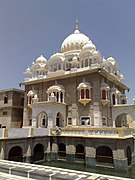 Gurdwara Panja Sahib in Punjab
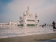 Darbar Sahib, gurdwara commemorating Guru Nanak, in Kartarpur, Pakistan


.jpg)

See also
Notes
- 1941 figure taken from census data by combining the total population of all administrative divisions that compose the region of contemporary Pakistan, including Punjab,'"`UNIQ--ref-0000011A-QINU`"': 42 '"`UNIQ--ref-0000011B-QINU`"' Sindh,'"`UNIQ--ref-0000011C-QINU`"': 28 '"`UNIQ--ref-0000011D-QINU`"' Khyber Pakhtunkhwa,'"`UNIQ--ref-0000011E-QINU`"': 22 '"`UNIQ--ref-0000011F-QINU`"' Balochistan,'"`UNIQ--ref-00000120-QINU`"': 13–18 Azad Jammu and Kashmir,'"`UNIQ--ref-00000121-QINU`"': 337–352 '"`UNIQ--ref-00000122-QINU`"' and Gilgit–Baltistan.'"`UNIQ--ref-00000123-QINU`"': 337–352 '"`UNIQ--ref-00000124-QINU`"'
- 1941 figure taken from census data by combining the total population of all districts (Lahore, Sialkot, Gujranwala, Sheikhupura, Gujrat, Shahpur, Jhelum, Rawalpindi, Attock, Mianwali, Montgomery, Lyallpur, Jhang, Multan, Muzaffargargh, Dera Ghazi Khan), one tehsil (Shakargarh – then part of Gurdaspur District), one princely state (Bahawalpur), and one tract (Biloch Trans–Frontier) in Punjab Province, British India that ultimately fell on the western side of the Radcliffe Line. See 1941 census data here: '"`UNIQ--ref-00000039-QINU`"': 42
Immediately following the partition of India in 1947, these districts and tract would ultimately make up the subdivision of West Punjab, which also later included Bahawalpur. The state that makes up this region in the contemporary era is Punjab, Pakistan. - 1901 figure taken from census data by combining the total population of all administrative divisions that compose the region of contemporary Pakistan, including Punjab,'"`UNIQ--ref-00000089-QINU`"''"`UNIQ--ref-0000008A-QINU`"' Sindh,'"`UNIQ--ref-0000008B-QINU`"''"`UNIQ--ref-0000008C-QINU`"' Khyber Pakhtunkhwa,'"`UNIQ--ref-0000008D-QINU`"' Balochistan,'"`UNIQ--ref-0000008E-QINU`"' Azad Jammu and Kashmir,'"`UNIQ--ref-0000008F-QINU`"''"`UNIQ--ref-00000090-QINU`"' and Gilgit–Baltistan.'"`UNIQ--ref-00000091-QINU`"''"`UNIQ--ref-00000092-QINU`"'
- 1911 figure taken from census data by combining the total population of all administrative divisions that compose the region of contemporary Pakistan, including Punjab,'"`UNIQ--ref-000000AE-QINU`"''"`UNIQ--ref-000000AF-QINU`"' Sindh,'"`UNIQ--ref-000000B0-QINU`"''"`UNIQ--ref-000000B1-QINU`"' Khyber Pakhtunkhwa,'"`UNIQ--ref-000000B2-QINU`"' Balochistan,'"`UNIQ--ref-000000B3-QINU`"' Azad Jammu and Kashmir,'"`UNIQ--ref-000000B4-QINU`"''"`UNIQ--ref-000000B5-QINU`"' and Gilgit–Baltistan.'"`UNIQ--ref-000000B6-QINU`"''"`UNIQ--ref-000000B7-QINU`"'
- 1921 figure taken from census data by combining the total population of all administrative divisions that compose the region of contemporary Pakistan, including Punjab,'"`UNIQ--ref-000000D4-QINU`"''"`UNIQ--ref-000000D5-QINU`"' Sindh,'"`UNIQ--ref-000000D6-QINU`"''"`UNIQ--ref-000000D7-QINU`"' Khyber Pakhtunkhwa,'"`UNIQ--ref-000000D8-QINU`"' Balochistan,'"`UNIQ--ref-000000D9-QINU`"' Azad Jammu and Kashmir,'"`UNIQ--ref-000000DA-QINU`"''"`UNIQ--ref-000000DB-QINU`"' and Gilgit–Baltistan.'"`UNIQ--ref-000000DC-QINU`"''"`UNIQ--ref-000000DD-QINU`"'
- 1931 figure taken from census data by combining the total population of all administrative divisions that compose the region of contemporary Pakistan, including Punjab,'"`UNIQ--ref-000000F7-QINU`"''"`UNIQ--ref-000000F8-QINU`"' Sindh,'"`UNIQ--ref-000000F9-QINU`"''"`UNIQ--ref-000000FA-QINU`"' Khyber Pakhtunkhwa,'"`UNIQ--ref-000000FB-QINU`"' Balochistan,'"`UNIQ--ref-000000FC-QINU`"' Azad Jammu and Kashmir,'"`UNIQ--ref-000000FD-QINU`"''"`UNIQ--ref-000000FE-QINU`"' and Gilgit–Baltistan.'"`UNIQ--ref-000000FF-QINU`"''"`UNIQ--ref-00000100-QINU`"'
- 1951 figure taken from census data by combining the total "Other" religious population of all administrative divisions that compose the region of contemporary Pakistan, including Punjab, Sindh, Khyber Pakhtunkhwa, and Balochistan.'"`UNIQ--ref-0000013A-QINU`"''"`UNIQ--ref-0000013B-QINU`"'
- 1901 figure taken from census data by combining the total population of all districts (Lahore, Sialkot, Gujranwala, Gujrat, Shahpur, Jhelum, Rawalpindi, Mianwali, Montgomery, Lyallpur (inscribed as the Chenab Colony on the 1901 census), Jhang, Multan, Muzaffargargh, Dera Ghazi Khan), one tehsil (Shakargarh – then part of Gurdaspur District), one princely state (Bahawalpur), and one tract (Biloch Trans–Frontier) in Punjab Province, British India that ultimately fell on the western side of the Radcliffe Line. See 1901 census data here: '"`UNIQ--ref-00000094-QINU`"'
Immediately following the partition of India in 1947, these districts and tract would ultimately make up the subdivision of West Punjab, which also later included Bahawalpur. The state that makes up this region in the contemporary era is Punjab, Pakistan. - Religious data only collected in North West Frontier Province, and not in the Federally Administered Tribal Areas. Total responses to religion includes North West Frontier Province, and total population includes both North West Frontier Province and the Federally Administered Tribal Areas, both administrative divisions which later amalgamated to become Khyber Pakhtunkhwa.
- 1901 figure taken from census data by combining the total population of two districts (Bhimber and Muzaffarabad) and one Jagir (Poonch) in the Princely State of Jammu and Kashmir that ultimately would be administered by Pakistan, in the contemporary self-administrative territory of Azad Jammu and Kashmir. See 1901 census data here:'"`UNIQ--ref-0000009E-QINU`"'
- 1901 figure taken from census data using the total population of Gilgit District in the Princely State of Jammu and Kashmir that ultimately would be administered by Pakistan, in the contemporary administrative territory of Gilgit–Baltistan. See 1901 census data here:'"`UNIQ--ref-000000A4-QINU`"'
- 1901 figure taken from census data by combining the total population of all districts (Karachi, Hyderabad, Shikarpur, Tharparkar, Upper Sind Frontier), and one princely state (Khairpur), in Sindh Province, British India. See 1901 census data here: '"`UNIQ--ref-000000A6-QINU`"'
- 1911 figure taken from census data by combining the total population of all districts (Lahore, Sialkot, Gujranwala, Gujrat, Shahpur, Jhelum, Rawalpindi, Attock, Mianwali, Montgomery, Lyallpur, Jhang, Multan, Muzaffargargh, Dera Ghazi Khan), one tehsil (Shakargarh – then part of Gurdaspur District), one princely state (Bahawalpur), and one tract (Biloch Trans–Frontier) in Punjab Province, British India that ultimately fell on the western side of the Radcliffe Line. See 1911 census data here: '"`UNIQ--ref-000000B9-QINU`"''"`UNIQ--ref-000000BA-QINU`"'
Immediately following the partition of India in 1947, these districts and tract would ultimately make up the subdivision of West Punjab, which also later included Bahawalpur. The state that makes up this region in the contemporary era is Punjab, Pakistan. - 1911 figure taken from census data by combining the total population of two districts (Mirpur and Muzaffarabad) and one Jagir (Poonch) in the Princely State of Jammu and Kashmir that ultimately would be administered by Pakistan, in the contemporary self-administrative territory of Azad Jammu and Kashmir. See 1911 census data here:'"`UNIQ--ref-000000C4-QINU`"'
- 1911 figure taken from census data by combining the total population of all districts (Hyderabad, Karachi, Larkana, Sukkur, Tharparkar, Upper Sind Frontier), and one princely state (Khairpur), in Sindh Province, British India. See 1911 census data here: '"`UNIQ--ref-000000C8-QINU`"'
- 1911 figure taken from census data by combining the total population of Gilgit District and the Frontier Ilaqas in the Princely State of Jammu and Kashmir that ultimately would be administered by Pakistan, in the contemporary administrative territory of Gilgit–Baltistan. See 1911 census data here:'"`UNIQ--ref-000000CE-QINU`"'
- 1921 figure taken from census data by combining the total population of all districts (Lahore, Sialkot, Gujranwala, Sheikhupura, Gujrat, Shahpur, Jhelum, Rawalpindi, Attock, Mianwali, Montgomery, Lyallpur, Jhang, Multan, Muzaffargargh, Dera Ghazi Khan), one tehsil (Shakargarh – then part of Gurdaspur District), one princely state (Bahawalpur), and one tract (Biloch Trans–Frontier) in Punjab Province, British India that ultimately fell on the western side of the Radcliffe Line. See 1921 census data here: '"`UNIQ--ref-000000DF-QINU`"'
Immediately following the partition of India in 1947, these districts and tract would ultimately make up the subdivision of West Punjab, which also later included Bahawalpur. The state that makes up this region in the contemporary era is Punjab, Pakistan. - 1921 figure taken from census data by combining the total population of two districts (Mirpur and Muzaffarabad) and one Jagir (Poonch) in the Princely State of Jammu and Kashmir that ultimately would be administered by Pakistan, in the contemporary self-administrative territory of Azad Jammu and Kashmir. See 1921 census data here:'"`UNIQ--ref-000000E7-QINU`"'
- 1921 figure taken from census data by combining the total population of all districts (Hyderabad, Karachi, Larkana, Nawabshah, Sukkur, Tharparkar, Upper Sind Frontier), and one princely state (Khairpur), in Sindh Province, British India. See 1921 census data here: '"`UNIQ--ref-000000EB-QINU`"'
- 1921 figure taken from census data by combining the total population of Gilgit District and the Frontier Ilaqas in the Princely State of Jammu and Kashmir that ultimately would be administered by Pakistan, in the contemporary administrative territory of Gilgit–Baltistan. See 1921 census data here:'"`UNIQ--ref-000000F1-QINU`"'
- 1931 figure taken from census data by combining the total population of all districts (Lahore, Sialkot, Gujranwala, Sheikhupura, Gujrat, Shahpur, Jhelum, Rawalpindi, Attock, Mianwali, Montgomery, Lyallpur, Jhang, Multan, Muzaffargargh, Dera Ghazi Khan), one tehsil (Shakargarh – then part of Gurdaspur District), one princely state (Bahawalpur), and one tract (Biloch Trans–Frontier) in Punjab Province, British India that ultimately fell on the western side of the Radcliffe Line. See 1931 census data here: '"`UNIQ--ref-00000102-QINU`"'
Immediately following the partition of India in 1947, these districts and tract would ultimately make up the subdivision of West Punjab, which also later included Bahawalpur. The state that makes up this region in the contemporary era is Punjab, Pakistan. - 1931 figure taken from census data by combining the total population of two districts (Mirpur and Muzaffarabad) and one Jagir (Poonch) in the Princely State of Jammu and Kashmir that ultimately would be administered by Pakistan, in the contemporary self-administrative territory of Azad Jammu and Kashmir. See 1931 census data here:'"`UNIQ--ref-0000010A-QINU`"'
- 1931 figure taken from census data by combining the total population of all districts (Hyderabad, Karachi, Larkana, Nawabshah, Sukkur, Tharparkar, Upper Sind Frontier), and one princely state (Khairpur), in Sindh Province, British India. See 1931 census data here: '"`UNIQ--ref-0000010E-QINU`"'
- 1931 figure taken from census data by combining the total population of Gilgit District and the Frontier Ilaqas in the Princely State of Jammu and Kashmir that ultimately would be administered by Pakistan, in the contemporary administrative territory of Gilgit–Baltistan. See 1931 census data here:'"`UNIQ--ref-00000114-QINU`"'
- 1941 figure taken from census data by combining the total population of two districts (Mirpur and Muzaffarabad) and one Jagir (Poonch) in the Princely State of Jammu and Kashmir that ultimately would be administered by Pakistan, in the contemporary self-administrative territory of Azad Jammu and Kashmir. See 1941 census data here:'"`UNIQ--ref-0000012D-QINU`"': 337–352
- 1941 figure taken from census data by combining the total population of all districts (Dadu, Hyderabad, Karachi, Larkana, Nawabshah, Sukkur, Tharparkar, Upper Sind Frontier), and one princely state (Khairpur), in Sindh Province, British India. See 1941 census data here: '"`UNIQ--ref-00000131-QINU`"'
- 1941 figure taken from census data by combining the total population of one district (Astore) and one agency (Gilgit) in the Princely State of Jammu and Kashmir that ultimately would be administered by Pakistan, in the contemporary administrative territory of Gilgit–Baltistan. See 1941 census data here:'"`UNIQ--ref-00000137-QINU`"': 337–352
- 1881 figure taken from census data by combining the total population of all districts (Lahore, Sialkot, Gujranwala, Gujrat, Shahpur, Jhelum, Rawalpindi, Montgomery, Jhang, Multan, Muzaffargargh, Dera Ghazi Khan), one tehsil (Shakargarh – then part of Gurdaspur District), and one princely state (Bahawalpur) in Punjab Province, British India that ultimately fell on the western side of the Radcliffe Line. See 1881 census data here: '"`UNIQ--ref-00000142-QINU`"''"`UNIQ--ref-00000143-QINU`"''"`UNIQ--ref-00000144-QINU`"'
Immediately following the partition of India in 1947, these districts and tract would ultimately make up the subdivision of West Punjab, which also later included Bahawalpur. The state that makes up this region in the contemporary era is Punjab, Pakistan. - Part of Gurdaspur District which was awarded to Pakistan as part of the Radcliffe Line.
- District formerly inscribed as the Chenab Colony on the 1901 census, later renamed to Lyallpur District, created between Jhang District, Gujranwala District, Lahore District, Montgomery District, and Multan District to account for the large population increase in the region, primarily due to the Chenab Canal Colony.
- District created in 1904 by taking Talagang Tehsil from Jhelum District and Pindi Gheb, Fateh Jang and Attock Tehsils from Rawalpindi District.
- District created between Gujranwala District, Sialkot District, Amritsar District, Lahore District, Montgomery District, and Lyallpur District in 1920 to account for the large population increase in the region, primarily due to the Chenab Canal Colony.
- Includes total Municipality and Cantonment population.
- Includes total Cantonment and Notified area population.
- Includes total Notified area population.
- Includes town and cantonment
References
External links
Wikiwand - on
Seamless Wikipedia browsing. On steroids.