Portal:World
Wikipedia portal for content related to the world / From Wikipedia, the free encyclopedia
Portal maintenance status: (No date set)
|
The World Portal


The world is the totality of entities, the whole of reality, or everything that exists. The nature of the world has been conceptualized differently in different fields. Some conceptions see the world as unique while others talk of a "plurality of worlds". Some treat the world as one simple object while others analyze the world as a complex made up of parts.
In scientific cosmology, the world or universe is commonly defined as "[t]he totality of all space and time; all that is, has been, and will be". Theories of modality talk of possible worlds as complete and consistent ways how things could have been. Phenomenology, starting from the horizon of co-given objects present in the periphery of every experience, defines the world as the biggest horizon or the "horizon of all horizons". In philosophy of mind, the world is contrasted with the mind as that which is represented by the mind. Theology conceptualizes the world in relation to God, for example, as God's creation, as identical to God or as the two being interdependent. In religions, there is a tendency to downgrade the material or sensory world in favor of a spiritual world to be sought through religious practice. A comprehensive representation of the world and our place in it, as is found in religions, is known as a worldview. Cosmogony is the field that studies the origin or creation of the world while eschatology refers to the science or doctrine of the last things or of the end of the world.
In various contexts, the term "world" takes a more restricted meaning associated, for example, with the Earth and all life on it, with humanity as a whole or with an international or intercontinental scope. In this sense, world history refers to the history of humanity as a whole and world politics is the discipline of political science studying issues that transcend nations and continents. Other examples include terms such as "world religion", "world language", "world government", "world war", "world population", "world economy", or "world championship". (Full article...)
Selected articles - show another
 Image 1
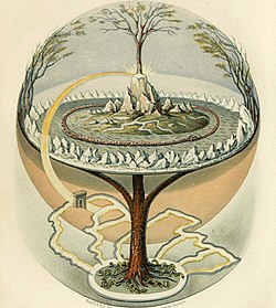
From Northern Antiquities, an English translation of the Prose Edda from 1847. Painted by Oluf Olufsen Bagge.
The world tree is a motif present in several religions and mythologies, particularly Indo-European, Siberian, and Native American religions. The world tree is represented as a colossal tree which supports the heavens, thereby connecting the heavens, the terrestrial world, and, through its roots, the underworld. It may also be strongly connected to the motif of the tree of life, but it is the source of wisdom of the ages.
Specific world trees include égig érő fa in Hungarian mythology, Ağaç Ana in Turkic mythology, Andndayin Ca˙r in Armenian mythology, Modun in Mongol mythology, Yggdrasil in Norse mythology, Irminsul in Germanic mythology, the oak in Slavic, Finnish and Baltic, Jianmu (Chinese: 建木; pinyin: jiànmù) in Chinese mythology, and in Hindu mythology the Ashvattha (a Ficus religiosa). (Full article...)- Image 2Around the World in 80 Days with Michael Palin is a 7-part BBC television travel series first broadcast on BBC1 in 1989. It was presented by comedian and actor Michael Palin. The show was inspired by Jules Verne's classic 1873 novel Around the World in Eighty Days, in which a character named Phileas Fogg accepts a wager to circumnavigate the globe in eighty days or less.
Palin was given the same deadline, and not allowed to use aircraft, which did not exist in Jules Verne's time and would make completing the journey far too easy. He followed Phileas Fogg's route as closely as possible. Along the way he commented on the sights and cultures he encountered. Palin encountered several setbacks during his voyage, partly because he travelled with a five-person film crew, who are collectively named after Passepartout, Phileas Fogg's manservant. (Full article...) - Image 3

The Space Race was a 20th-century competition between two Cold War rivals, the United States and the Soviet Union, to achieve superior spaceflight capability. It had its origins in the ballistic missile-based nuclear arms race between the two nations following World War II and had its peak with the more particular Moon Race to land on the Moon between the US moonshot and Soviet moonshot programs. The technological advantage demonstrated by spaceflight achievement was seen as necessary for national security and became part of the symbolism and ideology of the time. The Space Race brought pioneering launches of artificial satellites, robotic space probes to the Moon, Venus, and Mars, and human spaceflight in low Earth orbit and ultimately to the Moon.
Public interest in space travel originated in the 1951 publication of a Soviet youth magazine and was promptly picked up by US magazines. The competition began on July 30, 1955, when the United States announced its intent to launch artificial satellites for the International Geophysical Year. Four days later, the Soviet Union responded by declaring they would also launch a satellite "in the near future". The launching of satellites was enabled by developments in ballistic missile capabilities since the end of World War II. The competition gained Western public attention with the "Sputnik crisis", when the USSR achieved the first successful satellite launch, Sputnik 1, on October 4, 1957. It gained momentum when the USSR sent the first human, Yuri Gagarin, into space with the orbital flight of Vostok 1 on April 12, 1961. These were followed by a string of other early firsts achieved by the Soviets over the next few years. (Full article...) - Image 4The political history of the world is the history of the various political entities created by the human race throughout their existence and the way these states define their borders. Throughout history, political systems have expanded from basic systems of self-governance and monarchy to the complex democratic and totalitarian systems that exist today. In parallel, political entities have expanded from vaguely defined frontier-type boundaries, to the national definite boundaries existing today. (Full article...)
- Image 5

Old Moore's Almanack is an astrological almanac which has been published in Britain since 1697.
An almanac (also spelled almanack and almanach) is a regularly published listing of a set of current information about one or multiple subjects. It includes information like weather forecasts, farmers' planting dates, tide tables, and other tabular data often arranged according to the calendar. Celestial figures and various statistics are found in almanacs, such as the rising and setting times of the Sun and Moon, dates of eclipses, hours of high and low tides, and religious festivals. The set of events noted in an almanac may be tailored for a specific group of readers, such as farmers, sailors, or astronomers. (Full article...) - Image 6The Special Report on Global Warming of 1.5 °C (SR15) was published by the Intergovernmental Panel on Climate Change (IPCC) on 8 October 2018. The report, approved in Incheon, South Korea, includes over 6,000 scientific references, and was prepared by 91 authors from 40 countries. In December 2015, the 2015 United Nations Climate Change Conference called for the report. The report was delivered at the United Nations' 48th session of the IPCC to "deliver the authoritative, scientific guide for governments" to deal with climate change. Its key finding is that meeting a 1.5 °C (2.7 °F) target is possible but would require "deep emissions reductions" and "rapid, far-reaching and unprecedented changes in all aspects of society". Furthermore, the report finds that "limiting global warming to 1.5 °C compared with 2 °C would reduce challenging impacts on ecosystems, human health and well-being" and that a 2 °C temperature increase would exacerbate extreme weather, rising sea levels and diminishing Arctic sea ice, coral bleaching, and loss of ecosystems, among other impacts.
SR15 also has modelling that shows that, for global warming to be limited to 1.5 °C, "Global net human-caused emissions of carbon dioxide (CO2) would need to fall by about 45 percent from 2010 levels by 2030, reaching 'net zero' around 2050." The reduction of emissions by 2030 and its associated changes and challenges, including rapid decarbonisation, was a key focus on much of the reporting which was repeated through the world. (Full article...) - Image 7
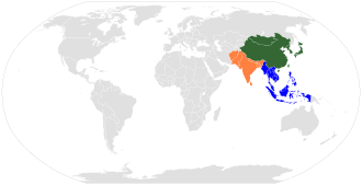
An image of the "Eastern world" defined as the "Far East", consisting of three overlapping cultural blocks: East Asia (green), Southeast Asia (blue), and South Asia (orange).
The Eastern world, also known as the East or historically the Orient, is an umbrella term for various cultures or social structures, nations and philosophical systems, which vary depending on the context. It most often includes Asia, the Mediterranean region and the Arab world, specifically in historical (pre-modern) contexts, and in modern times in the context of Orientalism. The Eastern world is often seen as a counterpart to the Western world.
The various regions included in the term are varied, hard to generalize, and do not have a single shared common heritage. Although the various parts of the Eastern world share many common threads, most notably being in the "Global South", they have never historically defined themselves collectively. The term originally had a literal geographic meaning, referring to the eastern part of the Old World, contrasting the cultures and civilizations of Asia with those of Europe (or the Western world). Traditionally, this includes Central Asia, East Asia, South Asia, Southeast Asia and West Asia. (Full article...)


General images - load new batch


 Image 3Artist's impression of Earth during the later Archean, the largely cooled planetary crust and water-rich barren surface, marked by volcanoes and continents, features already round microbialites. The Moon, still orbiting Earth much closer than today and still dominating Earth's sky, produced strong tides. (from History of Earth)
 Image 4Artist's conception of Hadean Eon Earth, when it was much hotter and inhospitable to all forms of life. (from History of Earth)
 Image 5Graph showing range of estimated partial pressure of atmospheric oxygen through geologic time (from History of Earth)
 Image 6Vitruvian Man by Leonardo da Vinci epitomizes the advances in art and science seen during the Renaissance. (from History of Earth)


 Image 10Pangaea was a supercontinent that existed from about 300 to 180 Ma. The outlines of the modern continents and other landmasses are indicated on this map. (from History of Earth)
 Image 12A view of Earth with different layers of its atmosphere visible: the troposphere with its clouds casting shadows, a band of stratospheric blue sky at the horizon, and a line of green airglow of the lower thermosphere around an altitude of 100 km, at the edge of space (from Earth)
 Image 13Great Mosque of Kairouan, Tunisia, founded 670 CE
 Image 14Battle during 1281 Mongol invasion of Japan
 Image 15Shanghai. China urbanized rapidly in the 21st century.
 Image 17Artist's rendition of an oxinated fully-frozen Snowball Earth with no remaining liquid surface water. (from History of Earth)
 Image 19An artist's impression of ice age Earth at glacial maximum. (from History of Earth)
 Image 20A 580 million year old fossil of Spriggina floundensi, an animal from the Ediacaran period. Such life forms could have been ancestors to the many new forms that originated in the Cambrian Explosion. (from History of Earth)

 Image 23Angkor Wat temple complex, Cambodia, early 12th century
 Image 24Earth's night-side upper atmosphere appearing from the bottom as bands of afterglow illuminating the troposphere in orange with silhouettes of clouds, and the stratosphere in white and blue. Next the mesosphere (pink area) extends to the orange and faintly green line of the lowest airglow, at about one hundred kilometers at the edge of space and the lower edge of the thermosphere (invisible). Continuing with green and red bands of aurorae stretching over several hundred kilometers. (from Earth)
 Image 26Pale orange dot, an artist's impression of Early Earth, featuring its tinted orange methane-rich early atmosphere (from Earth)

 Image 29A schematic view of Earth's magnetosphere with solar wind flowing from left to right (from Earth)
 Image 31Earth's land use for human agriculture in 2019 (from Earth)
 Image 32Ajloun Castle, Jordan
 Image 34Change in average surface air temperature and drivers for that change. Human activity has caused increased temperatures, with natural forces adding some variability. (from Earth)
 Image 35Atomic bombing of Nagasaki, 1945
 Image 36A map of heat flow from Earth's interior to the surface of Earth's crust, mostly along the oceanic ridges (from Earth)
 Image 38A view of Earth with its global ocean and cloud cover, which dominate Earth's surface and hydrosphere; at Earth's polar regions, its hydrosphere forms larger areas of ice cover. (from Earth)
 Image 39Tiktaalik, a fish with limb-like fins and a predecessor of tetrapods. Reconstruction from fossils about 375 million years old. (from History of Earth)
 Image 41Earth's axial tilt causing different angles of seasonal illumination at different orbital positions around the Sun (from Earth)
 Image 42A banded iron formation from the 3.15 Ga Moodies Group, Barberton Greenstone Belt, South Africa. Red layers represent the times when oxygen was available; gray layers were formed in anoxic circumstances. (from History of Earth)
 Image 43Olmec colossal head, now at the Museo de Antropología de Xalapa
 Image 44Dinosaurs were the dominant terrestrial vertebrates throughout most of the Mesozoic (from History of Earth)
 Image 45Astronaut Buzz Aldrin on the Moon, photographed by Neil Armstrong, 1969 (from History of Earth)
- Image 46An artist's impression of the Archean, the eon after Earth's formation, featuring round stromatolites, which are early oxygen-producing forms of life from billions of years ago. After the Late Heavy Bombardment, Earth's crust had cooled, its water-rich barren surface is marked by continents and volcanoes, with the Moon still orbiting Earth half as far as it is today, appearing 2.8 times larger and producing strong tides. (from Earth)

 Image 48A Benin Bronze head from Nigeria
 Image 50An animation of the changing density of productive vegetation on land (low in brown; heavy in dark green) and phytoplankton at the ocean surface (low in purple; high in yellow) (from Earth)
 Image 51Map of peopling of the world (Southern Dispersal paradigm), in thousands of years ago.
 Image 52Artist's impression of a Hadean landscape with the relatively newly formed Moon still looming closely over Earth and both bodies sustaining strong volcanism. (from History of Earth)
 Image 53Japanese depiction of a Portuguese carrack. European maritime innovations led to proto-globalization.
 Image 54Standing Buddha from Gandhara, 2nd century CE
 Image 56A pillar at Göbekli Tepe
 Image 57Tracy Caldwell Dyson, a NASA astronaut, observing Earth from the Cupola module at the International Space Station on 11 September 2010 (from Earth)
 Image 58The replicator in virtually all known life is deoxyribonucleic acid. DNA is far more complex than the original replicator and its replication systems are highly elaborate. (from History of Earth)


 Image 65Notre-Dame de Paris, France
 Image 66Fall of the Berlin Wall, 1989
 Image 67Chloroplasts in the cells of a moss (from History of Earth)
- Image 69The pale orange dot, an artist's impression of the early Earth which might have appeared orange through its hazy methane rich prebiotic second atmosphere. Earth's atmosphere at this stage was somewhat comparable to today's atmosphere of Titan. (from History of Earth)
 Image 70"Lucy", the first Australopithecus afarensis skeleton found. Lucy was only 1.06 m (3 ft 6 in) tall.
 Image 71The Pantheon, originally a Roman temple, now a Catholic church
 Image 72Lithified stromatolites on the shores of Lake Thetis, Western Australia. Archean stromatolites are the first direct fossil traces of life on Earth. (from History of Earth)
 Image 73Empires of the world in 1898

 Image 76Yggdrasil, an attempt to reconstruct the Norse world tree which connects the heavens, the world, and the underworld. (from World)
 Image 77Earth's western hemisphere showing topography relative to Earth's center instead of to mean sea level, as in common topographic maps (from Earth)
 Image 78A composite image of Earth, with its different types of surface discernible: Earth's surface dominating Ocean (blue), Africa with lush (green) to dry (brown) land and Earth's polar ice in the form of Antarctic sea ice (grey) covering the Antarctic or Southern Ocean and the Antarctic ice sheet (white) covering Antarctica. (from Earth)
 Image 79A reconstruction of human history based on fossil data. (from History of Earth)
 Image 80Artist's impression of the enormous collision that probably formed the Moon (from History of Earth)
 Image 81First airplane, the Wright Flyer, flew on 17 December 1903.
 Image 82Last Moon landing: Apollo 17 (1972)
 Image 83Trilobites first appeared during the Cambrian period and were among the most widespread and diverse groups of Paleozoic organisms. (from History of Earth)
 Image 84Great Pyramids of Giza, Egypt
 Image 85A computer-generated image mapping the prevalence of artificial satellites and space debris around Earth in geosynchronous and low Earth orbit (from Earth)
 Image 87Obelisk of Axum, Ethiopia
 Image 88Geologic map of North America, color-coded by age. From most recent to oldest, age is indicated by yellow, green, blue, and red. The reds and pinks indicate rock from the Archean.
 Image 90A 2012 artistic impression of the early Solar System's protoplanetary disk from which Earth and other Solar System bodies were formed (from Earth)


.jpg)


.jpg)


.jpeg)
.svg)


.jpg)


Megacities of the world - show another

Bangkok, officially known in Thai as Krung Thep Maha Nakhon and colloquially as Krung Thep, is the capital and most populous city of Thailand. The city occupies 1,568.7 square kilometres (605.7 sq mi) in the Chao Phraya River delta in central Thailand and has an estimated population of 9.0 million as of 2021, 13% of the country's population. Over 17.4 million people (25%) lived within the surrounding Bangkok Metropolitan Region at the 2021 estimate, making Bangkok an extreme primate city, dwarfing Thailand's other urban centres in both size and importance to the national economy.
Bangkok traces its roots to a small trading post during the Ayutthaya Kingdom in the 15th century, which eventually grew and became the site of two capital cities, Thonburi in 1767 and Rattanakosin in 1782. Bangkok was at the heart of the modernization of Siam, later renamed Thailand, during the late-19th century, as the country faced pressures from the West. The city was at the centre of Thailand's political struggles throughout the 20th century, as the country abolished absolute monarchy, adopted constitutional rule, and underwent numerous coups and several uprisings. The city, incorporated as a special administrative area under the Bangkok Metropolitan Administration in 1972, grew rapidly during the 1960s through the 1980s and now exerts a significant impact on Thailand's politics, economy, education, media and modern society. (Full article...)Did you know - load new batch

- ... that the 1968 Ruby Tower collapse was caused by an earthquake centered more than 200 km (120 mi) away?
- ... that Vice Admiral Ernst Scheurlen was killed in action a month before the end of the Second World War in Europe while leading a hastily raised division of naval troops in defence of Germany?
- ... that after being hijacked, United Airlines Flight 175 almost had two mid-air collisions with other aircraft before crashing into the South Tower of the World Trade Center?
- ... that the fossil turtle Acherontemys was named for a "river of the fabled lower world"?
- ... that VMB-611 was the only United States Marine Corps bombing squadron to operate in the Philippines during World War II?
- ... that the first public usage of the term "ongoing Nakba" is widely credited to Hanan Ashrawi, who referenced it in a speech at the 2001 World Conference against Racism?
- ... that Beryl Benacerraf, pioneer of the nuchal scan, wrote that dyslexia caused her to live in a world of images where "anomalies jump out at me like a neon sign"?
- ... that Ertuğrul Gazi, a Turkish floating storage and regasification unit for liquefied natural gas, has a daily capacity of 28 million cubic metres (990 million cu ft), among the world's largest?
Countries of the world - show another

Liberia (/laɪˈbɪəriə/ ⓘ), officially the Republic of Liberia, is a country on the West African coast. It is bordered by Sierra Leone to its northwest, Guinea to its north, Ivory Coast to its east, and the Atlantic Ocean to its south and southwest. It has a population of around five and one-half million and covers an area of 43,000 square miles (111,369 km2). The country's official language is English; however, over 20 indigenous languages are spoken, reflecting the country's ethnic and cultural diversity. The capital and largest city is Monrovia.
Liberia began in the early 19th century as a project of the American Colonization Society (ACS), which believed black people would face better chances for freedom and prosperity in Africa than in the United States. Between 1822 and the outbreak of the American Civil War in 1861, more than 15,000 freed and free-born African Americans, along with 3,198 Afro-Caribbeans, relocated to Liberia. Gradually developing an Americo-Liberian identity, the settlers carried their culture and tradition with them. Liberia declared independence on July 26, 1847, which the U.S. did not recognize until February 5, 1862. (Full article...)
The Seven Wonders of Ukraine (Ukrainian: Сім чудес України [ˈsʲim tʃʊˈdɛs ʊkrɐˈjinɪ]) are seven historical and cultural monuments of Ukraine, which were chosen in the Seven Wonders of Ukraine contest held in July, 2007. This was the first public contest of that kind which was followed by the Seven Natural Wonders of Ukraine, the Seven Wonderful Routes of Ukraine, and the Seven Wonderful Castles of Ukraine. All nominated sites are publicly owned protected areas of at least regional level, available for tourism.
The voting for all contests consisted of two parts: experts in Ukraine voted for their seven best sites, and internet users voted for their seven favorite sites on the official website. (Full article...)Related portals
Protected areas of the world - load new batch
- Image 1

Grand Canyon of Yellowstone
The protected areas of the United States are managed by an array of different federal, state, tribal and local level authorities and receive widely varying levels of protection. Some areas are managed as wilderness, while others are operated with acceptable commercial exploitation. , the 42,826 protected areas covered 1,235,486 km2 (477,024 sq mi), or 13 percent of the land area of the United States. This is also one-tenth of the protected land area of the world. The U.S. also had a total of 871 National Marine Protected Areas, covering an additional 1,240,000 sq mi (3,200,000 km2), or 26 percent of the total marine area of the United States. (Full article...) - Image 2Protected areas of Turkmenistan include nine nature reserves (zapovednik) and 13 sanctuaries (zakaznik) with a total area of 19,750 km2 or more than 4% of Turkmenistan's territory. (Full article...)
- Image 3
This list of protected areas of Quebec includes federally, provincially and municipally administered parks and wildlife reserves in Quebec, the largest province in Canada. (Full article...) - Image 4This is a list of protected areas of Romania.
About 5.18% of the area of Romania has a protected status (12,360 km2), including the Danube Delta, which makes half of these areas (2.43% of Romania's area). (Full article...) - Image 5

Part of the Brecon Beacons National Park, looking from the highest point of Pen y Fan (886 m/2907 feet) to Cribyn (795 m/2608 feet).
Protected areas of the United Kingdom are areas in the United Kingdom which need and /or receive protection because of their environmental, historical or cultural value to the nation. Methods and aims of protection vary depending on the nature and importance of the resource. Protection operates at local, regional, national and international levels, and may be backed by legislation and international treaty, or less formally by planning policy.
Within the United Kingdom, different approaches are taken to some forms of protection within the constituent countries of England, Scotland, Wales and Northern Ireland, while other forms of protection are more consistent across the UK. Protected areas can be divided according to the type of resource which each seeks to protect. Primarily, these are: scenic or landscape value; biodiversity value (species and habitats); geodiversity value (relating to geology and geomorphology); and cultural or historic value. Several types of protected areas are focused on more than one of these areas. (Full article...) - Image 6

A family of Asiatic lions at Gir National Park
The Gujarat state of western India has four National Parks and twenty-three wildlife sanctuaries which are managed by the Forest Department of the Government of Gujarat. (Full article...) - Image 7Protected areas of Norway include:
About 17 percent of the mainland of Norway is protected. Of this, ca. 8.3 percent is national parks, 1.3 percent is nature reserves and 4.7 percent otherwise protected. (Full article...) - Image 8The country of Burundi in Africa has the following national parks and other protected areas. (Full article...)
- Image 9The protected areas of Finland include national parks, nature reserves and other areas, with a purpose of conserving areas of all of Finland's ecosystems and biotopes.
Protected areas include:- National parks of Finland (Kansallispuisto/Nationalpark) - 8,170 km2
- Strict nature reserves of Finland (Luonnonpuisto/Naturreservat) - 1,530 km2
- Mire reserves of Finland (Soidensuojelualue/Myrskyddsområde) - 4,490 km2
- Protected herb-rich forest areas (Lehtojensuojelualue/Lundskyddsområde) - 13 km2
- Protected old-growth forest areas (Vanhat metsät/Gamla skogar) - 100 km2
- Grey seal protection areas (Hylkeidensuojelualue/Sälskyddsområde) - 190 km2
- Other protected areas on state-owned land - 468 km2
- Image 10
This is a list of protected areas of Yukon. The Yukon, formerly called Yukon Territory and sometimes referred to as just Yukon is the smallest and westernmost of Canada's three territories. It also is the least populated province or territory in Canada, with a population of 35,874 people as of the 2016 Census. (Full article...) - Image 11

Kejimkujik National Park, Little River
This is a list of protected areas of Nova Scotia. (Full article...) - Image 12

The protected areas of Bhutan are its national parks, nature preserves, and wildlife sanctuaries. Most of these protected areas were first set aside in the 1960s, originally covering most of the northern and southern regions of Bhutan. Today, protected areas cover more than 42% of the kingdom, mostly in the northern regions. Protected areas also line most of Bhutan's international borders with China and India. (Full article...) - Image 13The protected areas of Michigan come in an array of different types and levels of protection. Michigan has five units of the National Park Service system. There are 14 federal wilderness areas; the majority of these are also tribal-designated wildernesses. It has one of the largest state forest systems as well having four national forests. The state maintains a large state park system and there are also regional parks, and county, township and city parks. Still other parks on land and in the Great Lakes are maintained by other governmental bodies. Private protected areas also exist in the state, mainly lands owned by land conservancies. (Full article...)
- Image 14
Upolu Island, Samoa
This is a list of some protected areas of Samoa which include national parks, reservations, protected nature zones, marine reserves and other areas of significant biodiversity and conservation.
In 1994, Samoa ratified the international and legally binding treaty, the Convention on Biological Diversity to develop national strategies for conservation and sustainable use of biological diversity. In 2010, protected areas in the country cover 5% of land although the government aims to increase protected areas coverage to 15%. (Full article...) - Image 15

Vegetation outside Goz Beïda
The wildlife of Chad is composed of its flora and fauna. Bush elephants, West African lions, buffalo, hippopotamuses, Kordofan giraffes, antelopes, African leopards, cheetahs, hyenas, and many species of snakes are found there, although most large carnivore populations have been drastically reduced since the early 20th century. Elephant poaching, particularly in the south of the country in areas such as Zakouma National Park, is a severe problem. (Full article...)


Selected world maps
 Image 1The Goode homolosine projection is a pseudocylindrical, equal-area, composite map projection used for world maps.
 Image 2United Nations Human Development Index map by country (2016)
 Image 3Time zones of the world
 Image 4A plate tectonics map with volcano locations indicated with red circles
 Image 51516 map of the world by Martin Waldseemüller
 Image 6Index map from the International Map of the World (1:1,000,000 scale)
 Image 7Mollweide projection of the world
 Image 8The world map by Gerardus Mercator (1569), the first map in the well-known Mercator projection
 Image 9Only a few of the largest large igneous provinces appear (coloured dark purple) on this geological map, which depicts crustal geologic provinces as seen in seismic refraction data


World records
- List of Olympic records in athletics
- List of world records in athletics
- List of junior world records in athletics
- List of world records in masters athletics
- List of world youth bests in athletics
- List of IPC world records in athletics
- List of world records in canoeing
- List of world records in chess
- List of cycling records
- List of world records in track cycling
- List of world records in finswimming
- List of world records in juggling
- List of world records in rowing
- List of world records in speed skating
- List of world records in swimming
- List of IPC world records in swimming
- List of world records in Olympic weightlifting
Topics
Categories

Wikimedia
The following Wikimedia Foundation sister projects provide more on this subject:
-
 Commons
Free media repository -
 Wikibooks
Free textbooks and manuals -
 Wikidata
Free knowledge base -
 Wikinews
Free-content news -
 Wikiquote
Collection of quotations -
 Wikisource
Free-content library -
 Wikispecies
Directory of species -
 Wikiversity
Free learning tools -
 Wikivoyage
Free travel guide -
 Wiktionary
Dictionary and thesaurus


