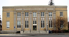
sir yn nhalaith Oregon, Unol Daleithiau America From Wikipedia, the free encyclopedia
Sir yn nhalaith Oregon, Unol Daleithiau America yw Deschutes County. Cafodd ei henwi ar ôl Afon Deschutes. Sefydlwyd Deschutes County, Oregon ym 1916 a sedd weinyddol y sir (a elwir weithiau'n 'dref sirol' neu'n 'brifddinas y sir') yw Bend.
 | |
| Math | sir |
|---|---|
| Enwyd ar ôl | Afon Deschutes |
| Prifddinas | Bend |
| Poblogaeth | 198,253 |
| Sefydlwyd | |
| Daearyddiaeth | |
| Gwlad | |
| Arwynebedd | 7,912 km² |
| Talaith | Oregon |
| Yn ffinio gyda | Linn County, Jefferson County, Crook County, Harney County, Lake County, Klamath County, Lane County |
| Cyfesurynnau | 43.91°N 121.22°W |
 | |
Mae ganddi arwynebedd o 7,912 cilometr sgwâr. Allan o'r arwynebedd hwn, y canran o ffurfiau dyfrol, megis llynnoedd ac afonydd, yw 1.2% . Yn ôl cyfrifiad y wlad, poblogaeth y sir yw: 198,253 (1 Ebrill 2020)[1][2]. Mewn cymhariaeth, yn 2016 roedd poblogaeth Caerdydd yn 361,462 a Rhyl tua 26,000.[3]
Mae'n ffinio gyda Linn County, Jefferson County, Crook County, Harney County, Lake County, Klamath County, Lane County. Cedwir rhestr swyddogol o henebion ac adeiladau cofrestredig y sir yn: National Register of Historic Places listings in Deschutes County, Oregon.
| [[File:Map of Oregon highlighting Deschutes County.svg|frameless]] | |
| Map o leoliad y sir o fewn Oregon | Lleoliad Oregon o fewn UDA |
Mae gan y sir yma boblogaeth o tua 198,253 (1 Ebrill 2020)[1][2]. Dyma rai o'r dinasoedd, trefi neu gymunedau mwyaf poblog y sir:
Rhestr Wicidata:
| Tref neu gymuned | Poblogaeth | Arwynebedd |
|---|---|---|
| Bend | 99178[4] | 86.144047[5] 33.27 86.146253[6] |
| Redmond | 33274[4] | 43.486938[5] 16.79 43.486963[6] |
| Deschutes River Woods | 5532[4] | 15.893176[5] 6 15.603756[6] |
| Crooked River Ranch | 4912[4] | 40.47[7] |
| Three Rivers | 3925[4] | 19.512367[5][6] 7.5 |
| Sisters | 3064[4] | 4.865249[5] 1.87 4.850324[6] |
| Eagle Crest Resort | 2761[4] | 39.4 15.2 39.354282[6] |
| La Pine | 2512[4] | 6.98 18.08 18.081716[6] |
| Sunriver | 2023[4] | 23.2 9 23.233024[6] |
| Terrebonne | 1393[4] | 2.628592[5][6] 1 |
| Tetherow | 811[4] | 5.462362[5] 2.11 5.461506[6] |
| Tumalo | 558[4] | 4.4 1.7 4.419831[6] |
| Seventh Mountain | 407[4] | 5.065009[5] 1.95[8] 5.065015[6] |
| Black Butte Ranch | 260[4] | 21.289721[5] 8.22 21.294236[6] |
| Pronghorn | 92[4] | 17.09519[5][6] 6.6 |
Seamless Wikipedia browsing. On steroids.
Every time you click a link to Wikipedia, Wiktionary or Wikiquote in your browser's search results, it will show the modern Wikiwand interface.
Wikiwand extension is a five stars, simple, with minimum permission required to keep your browsing private, safe and transparent.