Fil:Alexander-Empire_323bc.jpg
From Wikipedia, the free encyclopedia
Opphavleg fil (2 321 × 1 288 pikslar, filstorleik: 933 KB, MIME-type: image/jpeg)
Denne fila er frå Wikimedia Commons og kan verta nytta av andre prosjekt. Skildringa frå filskildringssida der er vist nedanfor.
Følgjande er henta frå filomtalen åt denne fila på Wikimedia Commons:
Innhaldsliste
Skildring

|
Dette historical map biletet bør verta oppretta på nytt som vektorgrafikk i SVG-format. Dette har fleire føremoner; sjå Commons:Media for cleanup for meir informasjon. Om ein SVG-versjon av dette biletet alt er tilgjengeleg, gjer vel og last han opp. Ettar å ha lasta opp ei SVG-fil, erstatt denne malen med {{vector version available|nytt biletnamn.svg}}.
|
 | This historical map image was uploaded in the JPEG format even though it consists of non-photographic data. This information could be stored more efficiently or accurately in the PNG or SVG format. If possible, please upload a PNG or SVG version of this image without compression artifacts, derived from a non-JPEG source (or with existing artifacts removed). After doing so, please tag the JPEG version with {{Superseded|NewImage.ext}} and remove this tag. This tag should not be applied to photographs or scans. If this image is a diagram or other image suitable for vectorisation, please tag this image with {{Convert to SVG}} instead of {{BadJPEG}}. If not suitable for vectorisation, use {{Convert to PNG}}. For more information, see {{BadJPEG}}. |  |
| SkildringAlexander-Empire 323bc.jpg |
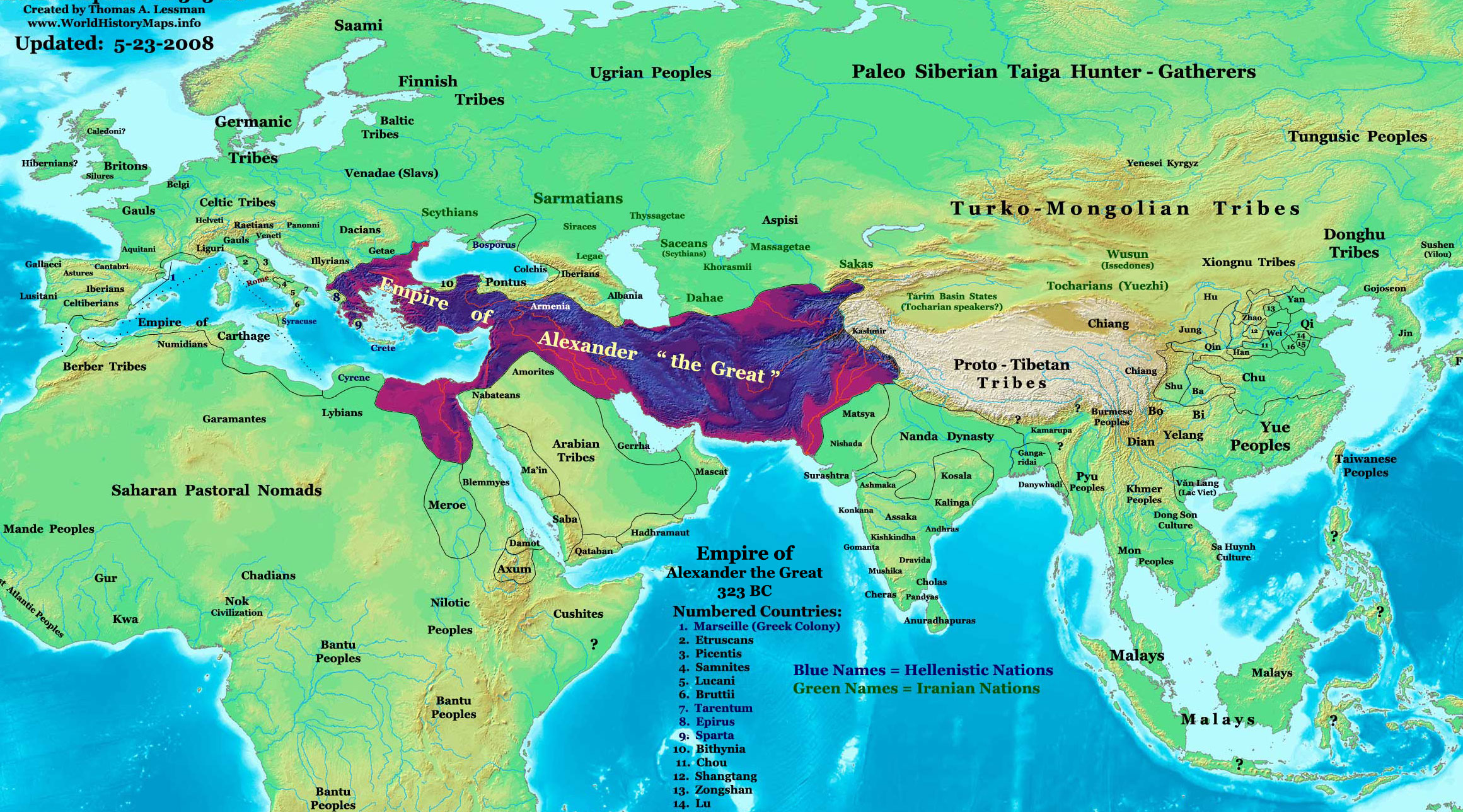
English: The Empire of Alexander the Great in 323 BC. |
| Dato | |
| Kjelde | Eige arbeid See the source info for East-Hem 323bc.jpg |
| Opphavsperson | Thomas Lessman (Contact!) |
| Løyve (Gjenbruk av denne fila) |
Eg, opphavsrettshaldaren til verket, publiserer det hermed under denne lisensen: Denne fila er lisensiert under lisensen Creative Commons Namngjeving-DelPåSameVilkåra 3.0 Unported
|
| Andre versjonar | see below |
Map Summary

Original Source URL: http://www.thomaslessman.com/History/images/East-Hem_001ad.jpg
This map is a zoomed-in version of Thomas Lessman's map of the
East-Hem_323bc.jpg (also available at www.WorldHistoryMaps.info).
The highlighted areas represent the Empire of Alexander the Great at his death in 323 BC.
Map Source References
- Remember, sources often conflict with each other. This map is only as accurate as the information that is available to me.
- To report any errors or to help further this work, please use the Corrections page, or email Thomas Lessman at talessman@yis.us
References for information contained in this map:
Empire of Alexander the Great information is derived from:
- The DK Atlas of World History, 2000 Edition; map of Alexander's Empire and successors; (Pg. 224)
- Wikimedia's map of The Empire of Alexander the Great uploaded by User talk:Captain Blood
- Wikipedia's article about Alexander the Great
I - European Information:
- Roman Republic borders are derived from The DK Atlas of World History, 2000 Edition; Pg. 178; Map of Italy in 240 BCE (also shows Roman borders in 300 BCE).
II - Asian Information:
- Chinese Area borders are derived from this map of The Contending States Boundries c. 350 BC, available on Huhai.net.
- Indian Kingdoms locations are derived from Wikimedia's map of Epic India.
- Gangaridai Note: the borders depicted for Gangaridai are not shown on any maps I've seen, they are described rather vaguely in the sources below:
- This article about The Origins of the Ganga Dynasty - A New Insight archive copy at the Wayback Machine by Dr. Harihar Kanungo; (Pg 25, section a).
- This article from Missouri Southern State University about Gangaridae in Megasthenes' Indica archive copy at the Wayback Machine; (Section 37).
- The History of Bengal website, which contains extensive information on an archeological site called Chandraketugarh, which may be the lost city of Ganga (the capital of Gangaridai).
- Nanda Dynasty borders are derived from:
- The DK Atlas of World History, 2000 Edition; Map of The Nanda and Mauryan Empires 365-181 BCE; (Pg. 241)
- Văn Lang borders are derived from:
- Wikimedia's map of Van Lang, created by User:Briangotts.
- Wikipedia's articles about Văn Lang and the Hồng Bàng Dynasty.
III - African Information and info for fringe areas like Africa, Australia, Siberia, etc. derive from:
- The DK Atlas of World History, 2000 Edition; map of The development of complex societies in Africa; (Page 160)
- Wikimedia's map of the World 323 BCE, created by User:Briangotts, and
- Wikimedia's map of the World in 300 BCE, created by User:Javierfv1212.
Note: Much of the information in this map was cross-checked with Bruce Gordon's Regnal Chronologies archive copy at the Wayback Machine.
Other Maps by Thomas Lessman
| Maps of the eastern hemisphere showing history
Bold dates are available on Wikimedia or Wikipedia. | ||
| Primeval | ||
| Ancient
|
·| 600 BC | 550 BC | 527 BC | 500 BC |
400 BC | ·| 1 AD | 50 AD | 100 AD | 200 AD | 300 AD | | |
| Medieval |
·| 500 AD | 565 AD | 600 AD | 700 AD | | |
| Modern |
·| 1500 AD | · * For historical maps of the whole world, | |
| history links talk edit view | ||
Other Info
Lisensiering:
- Du står fritt til å:
- til å dela – til å kopiera, distibuera og overføra arbeidet
- til å blanda – til å endra verket
- På desse vilkåra:
- namngjeving – Du lyt godskriva verket på den måten som opphavpersonen eller lisensgjevaren har oppgjeve (men ikkje på ein slik måte at det kan verka som om dei går god for deg eller måten du nyttar verket på).
- del på same vilkåra – Om du remiksar, omarbeider, eller på annan måte byggjer på dette verket, kan du berre distribuera resultatet under den same eller ein samsvarande lisens som denne.
Bilettekstar
Element som er med i denne fila
motiv
Verdi utan eit element på Wikidata
CC BY-SA 3.0 Unported norsk bokmål
30. januar 2008
image/jpeg
7691dbab36d234edd8294b705e20b2a03369447a
955 482 Byte i informatikk
1 288 piksel
2 321 piksel
Filhistorikk
Klikk på dato/klokkeslett for å sjå fila slik ho var på det tidspunktet.
| Dato/klokkeslett | Miniatyrbilete | Oppløysing | Brukar | Kommentar | |
|---|---|---|---|---|---|
| gjeldande | 23. mai 2008 kl. 16:02 | | 2 321 × 1 288 (933 KB) | Talessman | |Author= Talessman Category:Alexander the Great Category:Hellenistic age Category:Maps of Hellenistic States |
Filbruk
Den følgjande sida bruker denne fila:
Global filbruk
Desse andre wikiane nyttar fila:
- Bruk på azb.wikipedia.org
- Bruk på bg.wikipedia.org
- Bruk på crh.wikipedia.org
- Bruk på de.wikipedia.org
- Bruk på en.wikipedia.org
- Bruk på en.wikibooks.org
- Bruk på es.wikipedia.org
- Bruk på gom.wikipedia.org
- Bruk på he.wikipedia.org
- Bruk på id.wikipedia.org
- Bruk på ka.wikipedia.org
- Bruk på ml.wikipedia.org
- Bruk på ms.wikipedia.org
- Bruk på no.wikipedia.org
- Bruk på pt.wikipedia.org
- Bruk på ro.wikipedia.org
- Bruk på sr.wikipedia.org
- Bruk på sv.wikipedia.org
- Bruk på ta.wikipedia.org
- Bruk på te.wikipedia.org
- Bruk på vi.wikipedia.org
Utvida informasjon
Fila inneheld tilleggsopplysningar, mest sannsynleg frå digitalkameraet eller skannaren som vart brukt til å lage eller digitalisere henne.
Dersom fila har vore endra sidan ho vart oppretta, kan nokre av opplysningane vere feil.
| _error | 0 |
|---|