File:Moyen_Orient_13e_siècle.svg
維基百科,自由的 encyclopedia

原始檔案 (SVG 檔案,表面大小:1,885 × 1,354 像素,檔案大小:4.03 MB)
| This SVG file contains embedded text that can be translated into your language, using any capable SVG editor, text editor or the SVG Translate tool. For more information see: About translating SVG files. |
| 描述Moyen Orient 13e siècle.svg |
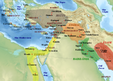
Català: Mapa que mostra l'extensió aproximada dels principals regnes de l'Orient Mitjà durant el segle XIII aC, amb les principals ciutats i jaciments arqueològics, i algunes regions. English: Map showing the approximate extension of the main kingdoms of the Middle East durint the 13th century BCE, with the main cities and archaeological sites, and some regions. Français : Carte montrant l'extension approximative des principaux royaumes du Moyen-Orient au XIIIe siècle av. J.-C., avec la localisation des villes et sites archéologiques principaux, ainsi que de certaines régions. |
| 日期 | (UTC) |
| 來源 | |
| 作者 |
|
| 其他版本 |
File:Moyen Orient 13e siècle.svg has 2 translations.
Other related versions: [編輯]
|


| This SVG file contains embedded text that can be translated into your language, using any capable SVG editor, text editor or the SVG Translate tool. For more information see: About translating SVG files. |
This file is translated using SVG <switch> elements. All translations are stored in the same file! Learn more.
For most Wikipedia projects, you can embed the file normally (without a To translate the text into your language, you can use the SVG Translate tool. Alternatively, you can download the file to your computer, add your translations using whatever software you're familiar with, and re-upload it with the same name. You will find help in Graphics Lab if you're not sure how to do this. |
| 這是一張修飾過的圖片,即本圖片是用軟體修改過後的版本,修改的方式或內容有:Ajout des royaumes, sites archéologiques et régions.。原版圖片來源:Middle East topographic map-blank.svg。修改者:Zunkir。
|
- 您可以自由:
- 分享 – 複製、發佈和傳播本作品
- 重新修改 – 創作演繹作品
- 惟需遵照下列條件:
- 姓名標示 – 您必須指名出正確的製作者,和提供授權條款的連結,以及表示是否有對內容上做出變更。您可以用任何合理的方式來行動,但不得以任何方式表明授權條款是對您許可或是由您所使用。
- 相同方式分享 – 如果您利用本素材進行再混合、轉換或創作,您必須基於如同原先的相同或兼容的條款,來分布您的貢獻成品。

|
已授權您依據自由軟體基金會發行的無固定段落、封面文字和封底文字GNU自由文件授權條款1.2版或任意後續版本,對本檔進行複製、傳播和/或修改。該協議的副本列在GNU自由文件授權條款中。http://www.gnu.org/copyleft/fdl.htmlGFDLGNU Free Documentation Licensetruetrue |
原始上傳日誌
This image is a derivative work of the following images:
- File:Middle_East_topographic_map-blank.svg licensed with Cc-by-sa-3.0,2.5,2.0,1.0, GFDL
- 2010-11-03T17:52:56Z Sémhur 3097x1938 (10510751 Bytes) == {{int:filedesc}} == {{Information |Description={{Multilingual description |en= Blank physical map of the [[:en:Middle East|Middle East]] |fr= Carte physique vierge du [[:fr:Moyen-Orient|Moyen-Orient]]. }} |Source={{own}}.
Uploaded with derivativeFX
說明
在此檔案描寫的項目
描繪內容
14 11 2010
image/svg+xml
檔案歷史
點選日期/時間以檢視該時間的檔案版本。
| 日期/時間 | 縮圖 | 尺寸 | 使用者 | 備註 | |
|---|---|---|---|---|---|
| 目前 | 2024年2月22日 (四) 16:02 | | 1,885 × 1,354(4.03 MB) | Manlleus | File uploaded using svgtranslate tool (https://svgtranslate.toolforge.org/). Added translation for ca. |
| 2024年2月22日 (四) 15:36 |  | 1,885 × 1,354(3.97 MB) | Manlleus | fixed text labels for translation | |
| 2011年10月28日 (五) 20:29 |  | 1,885 × 1,354(3.97 MB) | Zunkir | Police et remaniements mineurs. | |
| 2011年7月14日 (四) 10:15 |  | 1,885 × 1,354(3.97 MB) | Zunkir | Ajout du pays de Lukka. | |
| 2010年11月14日 (日) 11:01 |  | 1,885 × 1,354(3.97 MB) | Zunkir | {{Information |Description={{Multilingual description |fr= Carte montrant l'extension approximative des principaux royaumes du Moyen-Orient au XIIIe siècle av. J.-C., avec la localisation des villes et sites archéologiques principaux, ainsi que de certa |
檔案用途
沒有使用此檔案的頁面。
全域檔案使用狀況
以下其他 wiki 使用了這個檔案:
- ar.wikipedia.org 的使用狀況
- ca.wikipedia.org 的使用狀況
- Canaan
- Fenicis
- Babilònia
- Ugarit
- Alaixiya
- Història de Xipre
- Cartes d'Amarna
- Mitanni
- Batalla de Cadeix
- Hitites
- Història de Jordània
- Mesopotàmia
- Història de l'Iraq
- Antic Orient Pròxim
- Història de Mesopotàmia
- Llista dels reis de Babilònia
- Col·lapse de l'edat de bronze
- Datació de la Bíblia
- Període assiri mitjà
- Dinastia cassita
- en.wikipedia.org 的使用狀況
- es.wikipedia.org 的使用狀況
- fr.wikipedia.org 的使用狀況
- Phéniciens
- Bataille de Qadesh
- Mésopotamie
- Hittites
- Ougarit
- Histoire de l'Irak
- Histoire de Chypre
- Histoire de la Grèce antique
- Peuples de la mer
- Lettres d'Amarna
- Liste des souverains de Babylone
- Histoire de la Mésopotamie
- Histoire de la Jordanie
- Babylone (civilisation)
- Proche-Orient ancien
- Diplomatie dans le Proche-Orient ancien
- Mittani
- Alashiya
- Histoire des Hittites
- Utilisateur:Zunkir/POA autres
- Canaan (région)
- Culture au Moyen-Orient
- Datation de la Bible
檢視此檔案的更多全域使用狀況。
詮釋資料
此檔案中包含其他資訊,這些資訊可能是由數位相機或掃描器在建立或數位化過程中所新增的。若檔案自原始狀態已被修改,一些詳細資料可能無法完整反映出已修改的檔案。
| 寬度 | 1885 |
|---|---|
| 高度 | 1354 |