Dencukaay:Deutschland_Übersichtskarte.png
From Wikipedia, the free encyclopedia
réyal nataal bi ((1 979 × 2 518 pixels, réyaayu file bi : 7,01 Mio, type MIME : image/png))
Dencukaay bii Wikimedia Commons la bàyyikoo te man nañu koo jëfandikoo ci yeneen sémb. Faramfacce gi ci xëtu faramfaccewaayu xët wi lañuy wone ci suuf .
|
Faramfacce
| FaramfacceDeutschland Übersichtskarte.png |
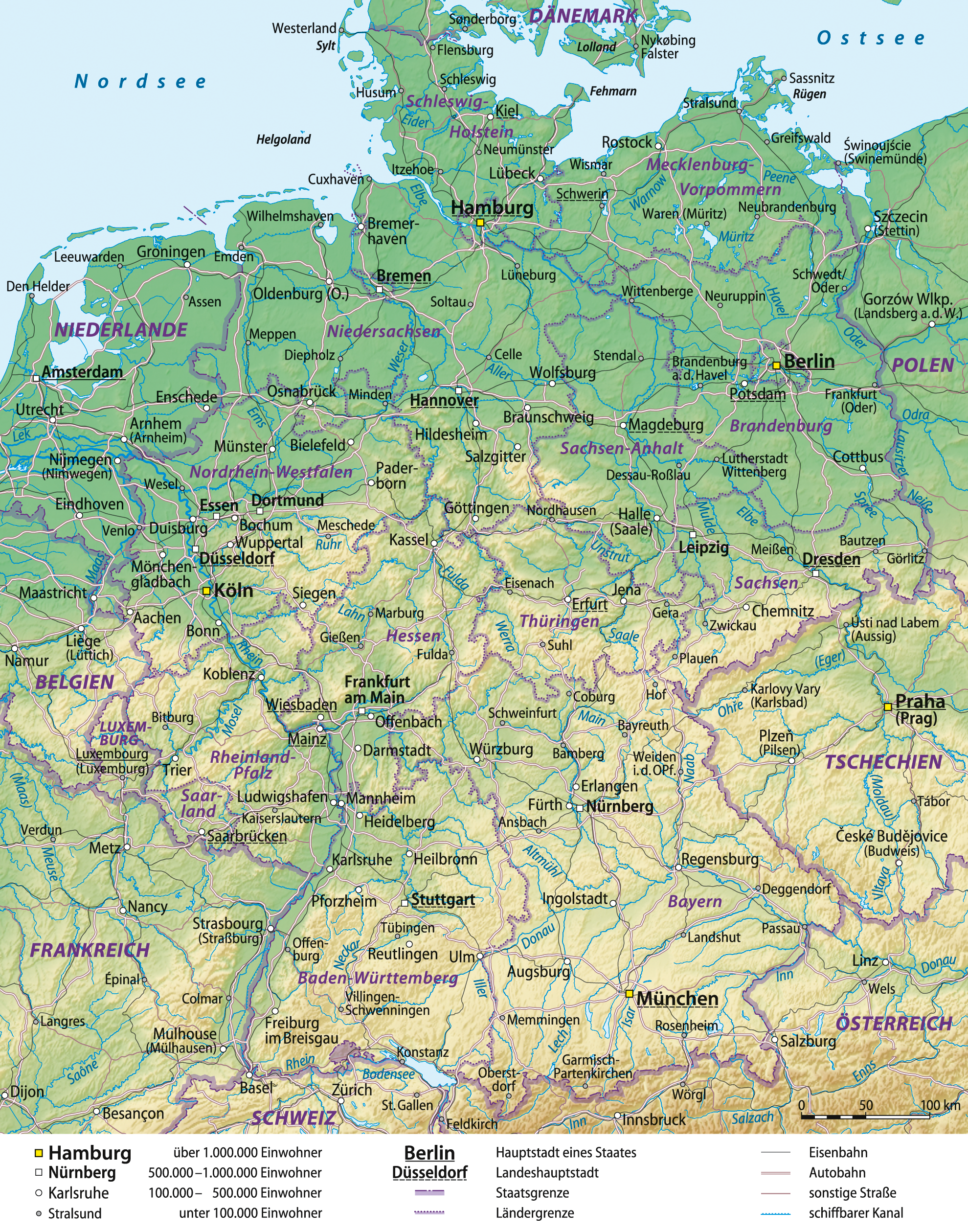
Deutsch: Übersichtskarte von Deutschland, deutsche Version
English: General map of Germany, German version
Français : Carte générale de l'Allemagne, en allemand
Español: Mapa general de Alemania, versión en alemán |
| Taariix | 03-06-2008 |
| Gongikuwaay |
self-made, using
|
| Aji-jëf | Lencer and NordNordWest |
| Autres versions |
|


|
Cette carte a été créée ou améliorée dans le Kartenwerkstatt (Atelier cartographique allemand). Vous pouvez également y proposer des cartes à améliorer.
azərbaycanca ∙ čeština ∙ Deutsch ∙ Deutsch (Sie-Form) ∙ English ∙ español ∙ français ∙ italiano ∙ latviešu ∙ magyar ∙ Nederlands ∙ Plattdüütsch ∙ polski ∙ português ∙ română ∙ sicilianu ∙ slovenščina ∙ suomi ∙ македонски ∙ русский ∙ ქართული ∙ հայերեն ∙ বাংলা ∙ ไทย ∙ +/−
|
Anami Jëfandikoo gi

|
Sañalees na duppi, séddale ak/walla soppi bile liggéey ci anami GNU Free Documentation License, Sumb 1.2 walla bépp sumb buFree Software Foundation mujjee siiwal; bu amul benn pàcc bees manul soppi, te amul it menn mbind ci xët wu njëkk week wu mujj wi. Ab sotti bu sañal gi jàppandi na ci pàcc bees duppee GNU Free Documentation License.http://www.gnu.org/copyleft/fdl.htmlGFDLGNU Free Documentation Licensetruetrue |
- Féeg nga ci:
- séddoo – duppi, séddale ak yónnee bile liggéey.
- soppi – soppi liggéey bi
- Ci kaw yii anam:
- Moomale – Fàww nga joxe ay xibaar yu leer ñeel boroom, joxe ab lëkkalekaay buy jëme ci sañal gi te wax ndax def nga ciy coppite. Man nga koo def ci anam yu bari, ba mu des ci guy wund ne aji-moom ji dafa ànd ak yaw walla ànd na ci ninga koy jëfandikoo)
- Séeddoo ci gii anamam – Soo soppee walla nga defar leneen te sukkadiku ci bii liggéey, faww nga siiwal ko ci genn sañal gi walla geneen gum méngool
Légendes
Éléments décrits dans ce fichier
dépeint Farañse
statut des droits d'auteur Farañse
sous droit d'auteur Farañse
Jaar-jaaru dencukaay bi
Cuqal cib taariix/waxtu ngir gis ni dencukaay bi meloon ca jamono jooju.
| Taariix ak Waxtu | Tuutal | Dayoo | Jëfandikukat | Saraa | |
|---|---|---|---|---|---|
| teew | 29 Disembar 2012 à 16:41 | | 1 979 × 2 518 (7,01 Mio) | NordNordWest | update |
| 29 Sulet 2009 à 07:48 |  | 1 979 × 2 518 (6,8 Mio) | NordNordWest | ||
| 10 Sattumbar 2008 à 19:05 |  | 1 979 × 2 521 (7,01 Mio) | NordNordWest | Autobahnen aktualisiert | |
| 16 Suwe 2008 à 14:01 |  | 1 979 × 2 521 (6,82 Mio) | NordNordWest | ||
| 11 Suwe 2008 à 16:17 |  | 1 978 × 2 521 (6,82 Mio) | NordNordWest | kleinere Korrekturen | |
| 6 Suwe 2008 à 10:02 |  | 1 977 × 2 521 (6,8 Mio) | NordNordWest | ||
| 5 Suwe 2008 à 14:30 |  | 1 978 × 2 521 (6,8 Mio) | NordNordWest | ||
| 5 Suwe 2008 à 10:12 |  | 1 986 × 2 525 (6,8 Mio) | NordNordWest | plus Grenzband | |
| 5 Suwe 2008 à 09:57 |  | 1 989 × 2 531 (6,79 Mio) | NordNordWest | Korrekturen, mit Eisenbahn | |
| 3 Suwe 2008 à 16:31 |  | 1 987 × 2 527 (6,6 Mio) | NordNordWest | {{Information |Description= {{de|Übersichtskarte von Deutschland}} {{en|General map of Germany}} |Source=self-made, using * Generic Mapping Tools * United States National Imagery and Mapp |
Xët yi am wii ŋara
Xët wii ci suuf ëmb na wii ŋara
Fépp fees jëfandikoo dencukaay bi
Yeneen wiki yiy toftal dañuy jëfandikoo itam bii dencukaay:
- Jëfandikoo nañu ko ci avk.wikipedia.org
- Jëfandikoo nañu ko ci be.wikipedia.org
- Jëfandikoo nañu ko ci de.wikipedia.org
- Geographie Deutschlands
- Benutzer:Lencer
- Benutzer:Lencer/Galerie
- Wikipedia:Exzellente Bilder/Karten und Satellitenbilder
- Benutzer:Warboerde/Baustelle2
- Benutzer:NatiSythen/Karten
- Wikipedia:Kartenwerkstatt/Archiv/2008-06
- Wikipedia:Kartenwerkstatt/Hilfe/GMT/Gallery
- Wikipedia:Kandidaten für exzellente Bilder/Archiv2008/10
- Datei:Deutschland Übersichtskarte.png
- Benutzer:Lencer/Unterseite
- Benutzer:Uwe Dedering/Länderliste
- Benutzer:Ulflulfl/Karten
- Wikipedia:Kartenwerkstatt/Blog/3
- Wikipedia:Kartenwerkstatt/Archiv/Zurückgewiesene und zurückgestellte Aufträge 2009
- Wikipedia:Kartenwerkstatt/Schaufenster
- Museen in Deutschland
- Benutzer:Runologe/Landkarten
- Jëfandikoo nañu ko ci en.wikipedia.org
- Jëfandikoo nañu ko ci fr.wikipedia.org
- Jëfandikoo nañu ko ci it.wikipedia.org
- Jëfandikoo nañu ko ci lb.wikipedia.org
- Jëfandikoo nañu ko ci rm.wikipedia.org
- Jëfandikoo nañu ko ci ru.wikipedia.org
- Jëfandikoo nañu ko ci th.wikipedia.org
- Jëfandikoo nañu ko ci tl.wikipedia.org
- Jëfandikoo nañu ko ci tr.wikipedia.org
- Jëfandikoo nañu ko ci uk.wikipedia.org
- Jëfandikoo nañu ko ci uz.wikipedia.org
Jégginjoxe
Bii dencukaay dafa ami xibaar yees ci yokk, xéj-na nataalukaay bu waaraame walla waaraamalekaay bees jëfandikoo moo leen ci yokk. Su fekkee soppees na xar-kanamu dencukaay bi, yenn ci fàramfacce ñeel ko manees nañoo bañ a dëppook li am.
| Résolution horizontale | 78,74 pt/cm |
|---|---|
| Résolution verticale | 78,74 pt/cm |