Tập_tin:Iss047e099713_lrg_Manila.jpg
From Wikipedia, the free encyclopedia
Tập tin gốc (4.928×3.280 điểm ảnh, kích thước tập tin: 5,17 MB, kiểu MIME: image/jpeg)
Tập tin này từ Wikimedia Commons. Trang miêu tả nó ở đấy được sao chép dưới đây. Commons là kho lưu trữ tập tin phương tiện có giấy phép tự do. Bạn có thể tham gia. |
Miêu tả
| Miêu tảIss047e099713 lrg Manila.jpg |
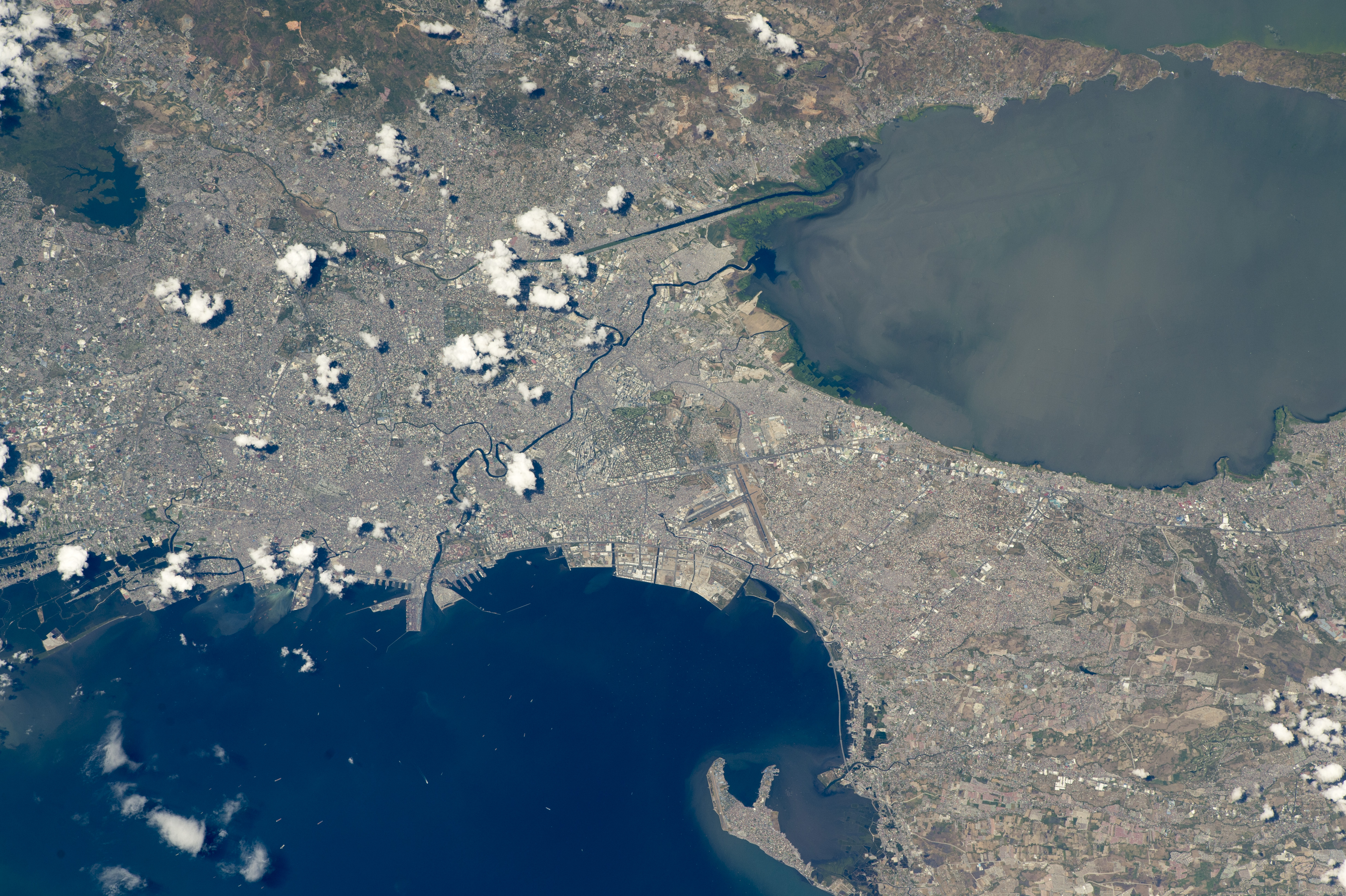
English: While orbiting over the South China Sea, an astronaut aboard the International Space Station (ISS) took this oblique photograph of the blocky red and gray urban pattern of Manila and surrounding cities. Manila is sandwiched between the salt water of Manila Bay—with its scatter of anchored ships—and Laguna de Bay. The great docks at the port can be seen jutting into Manila Bay (image center left), while the heart of the city lies immediately inland of the port. A forested nature reserve with a lake is located within one of the mountainous areas surrounding the metro zone (top left).
The combined population of Manila and neighboring Quezon City is 4.7 million people. Manila itself has one of the highest population densities in the world, with 42,857 people per square kilometer. The metropolitan area is the political and economic hub of the Philippines, and its international trade connections are so widespread the Globalization and World Cities Research Network classed Manila as a global city. Manila’s history has always been connected to trade. Arriving from Mexico, the conquistadors founded Manila in 1571, and soon the city became the Far East anchor of the Acapulco-Manila Galleon trade route connecting Spanish America with Asia. This represents one of the earliest examples of globalization. The dark lines of several waterways are prominent amidst the gray cityscape. The Pasig River winds through the middle of the city. The straight line of the Manggahan Floodway is a flood-control channel engineered to divert water from the Marikina River away from the city center and into Laguna de Bay. Engineering works along the floodway also control tidal saltwater flow into Laguna de Bay. Astronaut photograph ISS047-E-99713 was acquired on May 6, 2016, with a Nikon D4 digital camera using a 400 millimeter lens, and is provided by the ISS Crew Earth Observations Facility and the Earth Science and Remote Sensing Unit, Johnson Space Center. The image was taken by a member of the Expedition 47 crew. The image has been cropped and enhanced to improve contrast, and lens artifacts have been removed. The International Space Station Program supports the laboratory as part of the ISS National Lab to help astronauts take pictures of Earth that will be of the greatest value to scientists and the public, and to make those images freely available on the Internet. Additional images taken by astronauts and cosmonauts can be viewed at the NASA/JSC Gateway to Astronaut Photography of Earth. Caption by M. Justin Wilkinson, Texas State University, Jacobs Contract at NASA-JSC. |
||
| Ngày | |||
| Nguồn gốc | http://earthobservatory.nasa.gov/IOTD/view.php?id=88643 | ||
| Tác giả | Astronaut photograph ISS047-E-99713 was acquired on May 6, 2016, with a Nikon D4 digital camera using a 400 millimeter lens, and is provided by the ISS Crew Earth Observations Facility and the Earth Science and Remote Sensing Unit, Johnson Space Center. | ||
| Phiên bản khác |
|
.jpg)
.jpg)
.jpg)
| Vị trí máy chụp hình | 14° 35′ 00″ B, 121° 00′ 00″ Đ | Xem hình này và các hình ảnh lân cận trên: OpenStreetMap |
|---|
Giấy phép
| Public domainPublic domainfalsefalse |
| This file is in the public domain in the United States because it was solely created by NASA. NASA copyright policy states that "NASA material is not protected by copyright unless noted". (See Template:PD-USGov, NASA copyright policy page or JPL Image Use Policy.) | ||
 |
Warnings:
|
Chú thích
Khoản mục được tả trong tập tin này
mô tả
6 5 2016
captured with Tiếng Anh
Nikon D4 Tiếng Anh
15°N, 121°E
exposure time Tiếng Anh
0,00125 giây
f-number Tiếng Anh
11
focal length Tiếng Anh
400 milimét
ISO speed Tiếng Anh
200
image/jpeg
Lịch sử tập tin
Nhấn vào ngày/giờ để xem nội dung tập tin tại thời điểm đó.
| Ngày/giờ | Hình xem trước | Kích cỡ | Thành viên | Miêu tả | |
|---|---|---|---|---|---|
| hiện tại | 17:44, ngày 31 tháng 8 năm 2016 | | 4.928×3.280 (5,17 MB) | Melikamp | User created page with UploadWizard |
Trang sử dụng tập tin
Sử dụng tập tin toàn cục
Những wiki sau đang sử dụng tập tin này:
- Trang sử dụng tại ar.wikipedia.org
- Trang sử dụng tại ast.wikipedia.org
- Trang sử dụng tại ba.wikipedia.org
- Trang sử dụng tại bcl.wikipedia.org
- Trang sử dụng tại bg.wikipedia.org
- Trang sử dụng tại ca.wikipedia.org
- Trang sử dụng tại cbk-zam.wikipedia.org
- Trang sử dụng tại cs.wikipedia.org
- Trang sử dụng tại de.wikivoyage.org
- Trang sử dụng tại en.wikivoyage.org
- Trang sử dụng tại eo.wikipedia.org
- Trang sử dụng tại eu.wikipedia.org
- Trang sử dụng tại fa.wikipedia.org
- Trang sử dụng tại gl.wikipedia.org
- Trang sử dụng tại he.wikivoyage.org
- Trang sử dụng tại ia.wikipedia.org
- Trang sử dụng tại ilo.wikipedia.org
- Trang sử dụng tại it.wikivoyage.org
- Trang sử dụng tại ka.wikipedia.org
- Trang sử dụng tại ms.wikipedia.org
- Trang sử dụng tại no.wikipedia.org
- Trang sử dụng tại pag.wikipedia.org
- Trang sử dụng tại pam.wikipedia.org
- Trang sử dụng tại pt.wikipedia.org
- Trang sử dụng tại ru.wikipedia.org
- Trang sử dụng tại sat.wikipedia.org
- Trang sử dụng tại sr.wikipedia.org
- Trang sử dụng tại tl.wikipedia.org
- Trang sử dụng tại tt.wikipedia.org
- Trang sử dụng tại uk.wikipedia.org
- Trang sử dụng tại vec.wikipedia.org
- Trang sử dụng tại www.wikidata.org
- Trang sử dụng tại zh.wikipedia.org
Đặc tính hình
Tập tin này chứa thông tin bổ sung, có thể được thêm từ máy ảnh kỹ thuật số hoặc máy quét được sử dụng để tạo hoặc số hóa tệp.
Nếu tập tin đã được sửa đổi so với trạng thái ban đầu, một số chi tiết có thể không phản ánh đầy đủ tập tin đã sửa đổi.
| Hãng máy ảnh | NIKON CORPORATION |
|---|---|
| Dòng máy ảnh | NIKON D4 |
| Thời gian mở ống kính | 1/800 giây (0,00125) |
| Số F | f/11 |
| Ngày giờ sinh dữ liệu | 06:10, ngày 6 tháng 5 năm 2016 |
| Độ dài tiêu cự thấu kính | 400 mm |
| Hướng | Thường |
| Phân giải theo bề ngang | 300 điểm/inch |
| Phân giải theo chiều cao | 300 điểm/inch |
| Phần mềm sử dụng | Adobe Photoshop CC 2014 (Macintosh) |
| Ngày giờ sửa tập tin | 15:52, ngày 25 tháng 8 năm 2016 |
| Chế độ phơi sáng | Ưu tiên độ mở ống kính |
| Điểm tốc độ ISO | 200 |
| Phiên bản Exif | 2.21 |
| Ngày giờ số hóa | 06:10, ngày 6 tháng 5 năm 2016 |
| Tốc độ cửa chớp | 9,643856 |
| Độ mở ống kính (APEX) | 6,918863 |
| Độ lệch phơi sáng | −1 |
| Khẩu độ cực đại qua đất | 3 APEX (f/2,83) |
| Chế độ đo | Lấy mẫu |
| Nguồn sáng | Không biết |
| Đèn chớp | Đèn flash không chớp |
| Ghi chú của tác giả | NASA 2071135 73.4F |
| Ngày giờ nhỏ hơn giây | 60 |
| Ngày giờ gốc nhỏ hơn giây | 60 |
| Ngày giờ số hóa nhỏ hơn giây | 60 |
| Không gian màu | Chưa hiệu chỉnh |
| Phân giải X trên mặt phẳng tiêu | 1.368,888885498 |
| Phân giải Y trên mặt phẳng tiêu | 1.368,888885498 |
| Đơn vị phân giải trên mặt phẳng tiêu | 3 |
| Phương pháp đo | Đầu đo vùng màu một mảnh |
| Nguồn tập tin | Máy chụp hình tĩnh kỹ thuật số |
| Loại cảnh | Hình chụp thẳng |
| Sửa hình thủ công | Thường |
| Chế độ phơi sáng | Phơi sáng tự động |
| Cân bằng trắng | Cân bằng trắng tự động |
| Tỷ lệ phóng lớn kỹ thuật số | 1 |
| Tiêu cự trong phim 35 mm | 400 mm |
| Kiểu chụp cảnh | Chuẩn |
| Điều khiển cảnh | Không có |
| Độ tương phản | Thường |
| Độ bão hòa | Thường |
| Độ sắc nét | Thường |
| Khoảng cách tới vật | Không biết |
| Số sêri của máy chụp hình | 2071135 |
| Ống kính được sử dụng | 400.0 mm f/2.8 |
| Đánh giá (trên 5) | 0 |
| Ngày sửa siêu dữ liệu lần cuối | 11:52, ngày 25 tháng 8 năm 2016 |
| ID duy nhất của tài liệu gốc | CA445F5A8120EE7F181607C2FB67904C |