File:Estonia_municipalities.png
From Wikipedia, the free encyclopedia
Size of this preview: 800 × 513 pixels. Other resolutions: 320 × 205 pixels | 640 × 411 pixels | 1,024 × 657 pixels | 1,280 × 821 pixels | 1,601 × 1,027 pixels.
ʻAsi ʻa e faitā auiiki ((1,601 × 1,027 meʻaʻata, ko e faile hono lahi: 82 KB, faʻahinga MIME: image/png))
This file is from Wikimedia Commons and may be used by other projects. The description on its file description page there is shown below.
Fakanounou
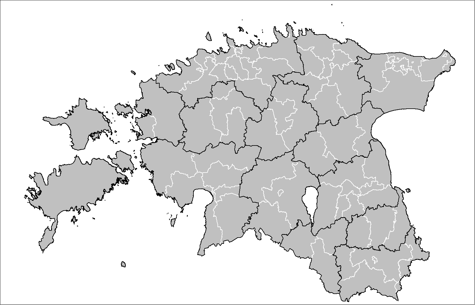
| FakamahinoEstonia municipalities.png | Map of the municipalities of Estonia after the 2017 municipal reform. Created by Rarelibra 15:43, 20 December 2006 (UTC) for public domain use, using MapInfo Professional v8.5 and various mapping resources. |
| Date | 20 Tisema 2006 (original upload date) |
| Tupunga | No machine-readable source provided. Own work assumed (based on copyright claims). |
| Author | No machine-readable author provided. Rarelibra assumed (based on copyright claims). |

|
This image could be re-created using vector graphics as an SVG file. This has several advantages; see Commons:Media for cleanup for more information. If an SVG form of this image is available, please upload it and afterwards replace this template with
{{vector version available|new image name}}.
It is recommended to name the SVG file “Estonia municipalities.svg”—then the template Vector version available (or Vva) does not need the new image name parameter. |
Laiseni:
| Public domainPublic domainfalsefalse |
| I, the copyright holder of this work, release this work into the public domain. This applies worldwide. In some countries this may not be legally possible; if so: I grant anyone the right to use this work for any purpose, without any conditions, unless such conditions are required by law. |
Captions
Add a one-line explanation of what this file represents
Items portrayed in this file
depicts lea fakapālangi
copyright status lea fakapālangi
copyrighted, dedicated to the public domain by copyright holder lea fakapālangi
copyright license lea fakapālangi
released into the public domain by the copyright holder lea fakapālangi
inception lea fakapālangi
20 Tisema 2006
Hisitōlia ʻo e faile
Lomiʻi ha ʻaho/taimi ki he vakai ʻo e faile naʻe ʻi ai he taimi ko iá.
| ʻAho/Taimi | ʻAtasiʻi | Hono lahi | ʻEtita | Fakamatala | |
|---|---|---|---|---|---|
| taka | 19:50, 8 ʻEpeleli 2019 | | 1,601 × 1,027 (82 KB) | H2ppyme | Fixed Kohila Parish |
| 14:51, 8 Tisema 2017 |  | 1,601 × 1,027 (72 KB) | RoMex | Updated according to the 2017 municipal reform. | |
| 07:33, 10 Maʻasi 2017 |  | 1,601 × 1,027 (102 KB) | H2ppyme | Corrected borders of Põlva and Rakvere parishes and Võhma Town. | |
| 01:44, 4 Sānuali 2015 |  | 1,601 × 1,027 (122 KB) | Flying Saucer | updated Lääne-Saare Parish | |
| 23:35, 25 ʻOkatopa 2013 |  | 1,601 × 1,027 (122 KB) | Flying Saucer | October 2013 updates | |
| 12:30, 2 Sēpitema 2010 |  | 1,601 × 1,027 (110 KB) | H2ppyme | Kaisma Parish merged with Vändra Parish | |
| 13:40, 24 Maʻasi 2008 |  | 1,601 × 1,027 (76 KB) | Rarelibra | updated map style | |
| 17:39, 8 Sānuali 2007 |  | 1,281 × 878 (56 KB) | Rarelibra | Updated map of the municipalities of Estonia (due to 2006 updates). | |
| 15:43, 20 Tisema 2006 |  | 1,281 × 878 (41 KB) | Rarelibra | Map of the municipalities of Estonia. Created by ~~~~ for public domain use, using MapInfo Professional v8.5 and various mapping resources. |
Faitā fehokotaki
ʻOku fehokotaki ʻa e ngaahi peesi ki he failé ni:
Global file usage
The following other wikis use this file:
- Usage on ar.wikipedia.org
- Usage on arz.wikipedia.org
- Usage on ba.wikipedia.org
- Usage on bn.wikipedia.org
- Usage on bs.wikipedia.org
- Usage on ca.wikipedia.org
- Usage on ceb.wikipedia.org
- Usage on cs.wikipedia.org
- Usage on da.wikipedia.org
- Usage on de.wikipedia.org
- Usage on el.wikipedia.org
- Usage on en.wikipedia.org
- Usage on et.wikipedia.org
- Eesti
- Eesti külade loend
- Arutelu:Eesti
- Eesti haldusüksuste lippude loend
- Eesti haldusjaotus
- URBACT
- Eesti regionaalpoliitika
- Eesti omavalitsuste haldusreform
- Eesti haldusüksuste vappide loend
- Vikipeedia arutelu:Vikiprojekt KOV 2017
- Kasutaja:Telempe/Mall:KOV2017
- Mall:Eesti maakondade lippude kaart
- Mall:Eesti maakondade vappide kaart
- Usage on fa.wikipedia.org
- Usage on fiu-vro.wikipedia.org
- Usage on fi.wikipedia.org
- Usage on fr.wikipedia.org
- Usage on hu.wikipedia.org
- Usage on it.wikipedia.org
- Usage on ja.wikipedia.org
- Usage on ka.wikipedia.org
- Usage on la.wikipedia.org
- Usage on mk.wikipedia.org
- Usage on my.wikipedia.org
- Usage on nl.wikipedia.org
- Usage on nn.wikipedia.org
- Usage on no.wikipedia.org
View more global usage of this file.
Metadata
This file contains additional information, probably added from the digital camera or scanner used to create or digitize it.
If the file has been modified from its original state, some details may not fully reflect the modified file.
| Auiiki fakalava | 37.79 dpc |
|---|---|
| Auiiki tuʻutonu | 37.79 dpc |
Retrieved from "https://to.wikipedia.org/wiki/File:Estonia_municipalities.png"