ไฟล์:Pacific_typhoon_tracks_1980-2005.jpg
From Wikipedia, the free encyclopedia
ขนาดของตัวอย่างนี้: 783 × 600 พิกเซล ความละเอียดอื่น: 313 × 240 พิกเซล | 627 × 480 พิกเซล | 1,003 × 768 พิกเซล | 1,280 × 980 พิกเซล | 2,560 × 1,961 พิกเซล | 4,700 × 3,600 พิกเซล
ดูภาพที่มีความละเอียดสูงกว่า (4,700 × 3,600 พิกเซล, ขนาดไฟล์: 4.04 เมกะไบต์, ชนิดไมม์: image/jpeg)
| รูปภาพหรือไฟล์เสียงนี้ ต้นฉบับอยู่ที่ คอมมอนส์ รายละเอียดด้านล่าง เป็นข้อความที่แสดงผลจาก ไฟล์ต้นฉบับในคอมมอนส์
|
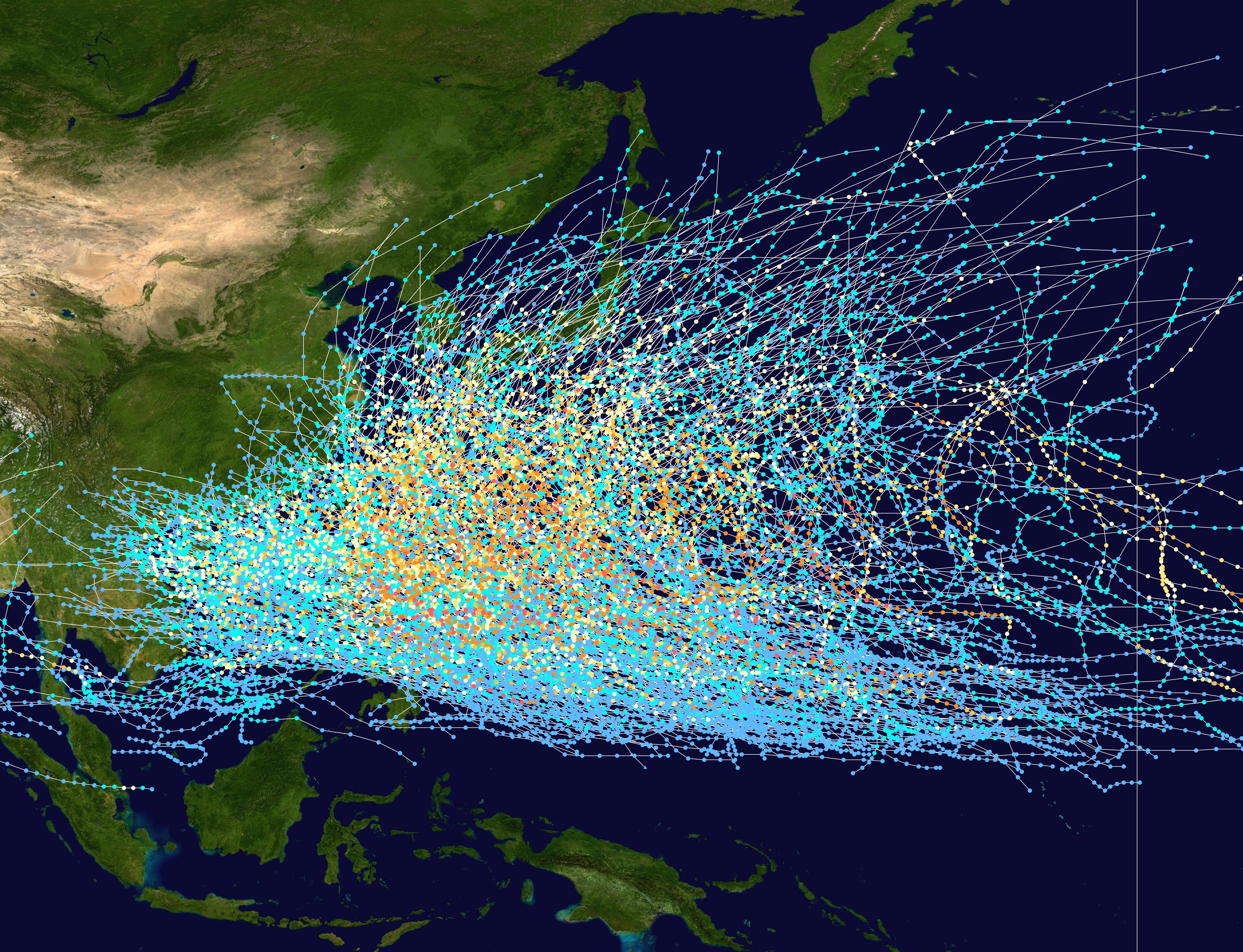
| คำอธิบายPacific typhoon tracks 1980-2005.jpg |
English: This trackmap shows the tracks of all tropical cyclones in the Northwest Pacific Ocean from 1980 to 2005. The International Date Line is marked on the map, this is the eastern boundary of the basin.. The points show the location of each storm at 6-hour intervals. The colour represents the storm's maximum sustained wind speeds as classified in the Saffir-Simpson Hurricane Scale (see below), and the shape of the data points represent the nature of the storm.
Storm type |
| วันที่ | 1980–2005 |
| แหล่งที่มา | Created using Wikipedia:WikiProject Tropical cyclones/Tracks. The background image is from NASA [1]. The tracking data is from the Joint Typhoon Warning Center's best track database |
| ผู้สร้างสรรค์ | Nilfanion |
| Public domainPublic domainfalsefalse |
| งานนี้ได้ถูกเผยแพร่สู่สาธารณสมบัติโดยเจ้าของ Nilfanion ซึ่งมีผลทั่วโลก ในบางประเทศ การกระทำดังกล่าวอาจไม่สามารถทำได้ตามกฎหมาย Nilfanion อนุญาตให้ทุกคนมีสิทธิ์ในการใช้ไฟล์นี้ในทุกเหตุผลการใช้ โดยไม่มีมีเงื่อนไข เว้นแต่กฎหมายไม่อนุญาตให้ทำเช่นนั้น |
คำบรรยายโดยย่อ
เพิ่มคำบรรยายทรรทัดเดียวเพื่อขยายความว่าไฟล์นี้มีอะไร
Typhoon Tracks in the Western Pacific
ไอเทมที่แสดงอยู่ในไฟล์นี้
ประกอบด้วย
media type อังกฤษ
image/jpeg
ประวัติไฟล์
คลิกวันที่/เวลาเพื่อดูไฟล์ที่ปรากฏในขณะนั้น
| วันที่/เวลา | รูปย่อ | ขนาด | ผู้ใช้ | ความเห็น | |
|---|---|---|---|---|---|
| ปัจจุบัน | 04:21, 28 กุมภาพันธ์ 2550 | | 4,700 × 3,600 (4.04 เมกะไบต์) | Nilfanion | {|Description={|align="{{{align|right}}}" border="0" cellspacing="0" cellpadding="0" style="background:transparent;text-align:center" |- |colspan="7" nowrap="nowrap"| <small>Saffir-Simpson Hurricane Scale</small> |- |s |
หน้าที่มีภาพนี้
หน้าต่อไปนี้ โยงมาที่ภาพนี้:
การใช้ไฟล์ข้ามโครงการ
วิกิอื่นต่อไปนี้ใช้ไฟล์นี้:
- การใช้บน az.wikipedia.org
- การใช้บน be-tarask.wikipedia.org
- การใช้บน be.wikipedia.org
- การใช้บน de.wikipedia.org
- การใช้บน en.wikipedia.org
- การใช้บน fr.wikipedia.org
- การใช้บน hak.wikipedia.org
- การใช้บน hy.wikipedia.org
- การใช้บน ja.wikipedia.org
- การใช้บน ka.wikipedia.org
- การใช้บน kk.wikipedia.org
- การใช้บน krc.wikipedia.org
- การใช้บน lez.wikipedia.org
- การใช้บน ms.wikipedia.org
- การใช้บน pt.wikipedia.org
- การใช้บน ru.wikipedia.org
- การใช้บน tl.wikipedia.org
- การใช้บน tyv.wikipedia.org
- การใช้บน uk.wikipedia.org
- การใช้บน uz.wikipedia.org
- การใช้บน vi.wikipedia.org
- การใช้บน zh.wikipedia.org
ข้อมูลเกี่ยวกับภาพ
ภาพนี้มีข้อมูลเพิ่มเติม ซึ่งส่วนใหญ่มาจากกล้องดิจิตอลหรือสแกนเนอร์ที่สามารถเก็บข้อมูลดังกล่าวไว้รวมกับภาพได้ ถ้าภาพนี้ถูกปรับปรุงแก้ไขหรือเปลี่ยนแปลงจากเดิม ข้อมูลบางอย่างจะยังคงไม่เปลี่ยนแปลงเหมือนภาพที่ถูกปรับปรุงแก้ไขนั้น
| _error | 0 |
|---|