prefecture of Japan From Wikipedia, the free encyclopedia
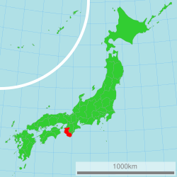
Wakayama Prefecture (和歌山県, Wakayama-ken) is a prefecture in the Kansai region of Japan on the island of Honshū.[1] The capital is the city of Wakayama.[2] Wakayama Prefecture is surrounded by Osaka Prefecture, Nara Prefecture, Mie Prefecture, Hyogo Prefecture and Tokushima Prefecture.
Wakayama
和歌山県 | |
|---|---|
| Japanese transcription(s) | |
| • Romaji | Wakayama-ken |
 Location of Wakayama in Japan | |
| Coordinates: 34°13′33.7″N 135°10′3.0″E | |
| Country | |
| Region | Kansai |
| Island | Honshū |
| Capital | Wakayama |
| Government | |
| • Governor | Shuhei Kishimoto |
| Area | |
| • Total | 4,725.67 km2 (1,824.59 sq mi) |
| • Rank | 30th |
| Population (April 1, 2012) | |
| • Total | 989,983 |
| • Rank | 39th |
| • Density | 210/km2 (540/sq mi) |
| ISO 3166 code | JP-30 |
| Prefectural flower | Ume blossom (Prunus mume) |
| Prefectural tree | Ubame oak (Quercus phillyraeoides) |
| Prefectural bird | Japanese white-eye (Zosterops japonica) |
| Number of districts | 6 |
| Number of municipalities | 30 |
| Website | www.wakayama.lg.jp/ english/ |
In the Meiji period, Wakayama Prefecture was created from the western part of Kii Province.[3]
Wakayama's southwestern coastline faces the Seto Inland Sea and its southeastern coastline is on the Pacific Ocean. The northern borders of the prefecture meet Osaka Prefecture, Nara Prefecture, and Mie Prefecture.
There are nine cities in Wakayama Prefecture:
|
|
|
These are the towns and villages in each district:
|
|
|
National Parks are established in about 9% of the total land area of the prefecture.[4]
Hinokuma-kunikakasu jinjū is the chief Shinto shrine (ichinomiya) in the prefecture.[5]
Seamless Wikipedia browsing. On steroids.
Every time you click a link to Wikipedia, Wiktionary or Wikiquote in your browser's search results, it will show the modern Wikiwand interface.
Wikiwand extension is a five stars, simple, with minimum permission required to keep your browsing private, safe and transparent.