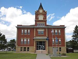
Rawlins County, Kansas
county in Kansas, United States From Wikipedia, the free encyclopedia
county in Kansas, United States From Wikipedia, the free encyclopedia
Rawlins County (standard abbreviation: RA) is a county in the U.S. state of Kansas. In 2020, 2,561 people lived there.[1] The county seat is Atwood. Atwood is also the biggest city in Rawlins County.[2] It was named after Union Civil War General John Aaron Rawlins.
Rawlins County | |
|---|---|
 Rawlins County Courthouse in Atwood (2010) | |
 Location within the U.S. state of Kansas | |
 Kansas's location within the U.S. | |
| Coordinates: 39°48′N 101°06′W | |
| Country | |
| State | |
| Founded | March 20, 1873 |
| Named for | John Aaron Rawlins |
| Seat | Atwood |
| Largest city | Atwood |
| Area | |
| • Total | 1,070 sq mi (2,800 km2) |
| • Land | 1,069 sq mi (2,770 km2) |
| • Water | 0.2 sq mi (0.5 km2) 0.01% |
| Population | |
| • Total | 2,561 |
| • Density | 2.4/sq mi (0.9/km2) |
| Time zone | UTC−6 (Central) |
| • Summer (DST) | UTC−5 (CDT) |
| Area code | 785 |
| Congressional district | 1st |
| Website | www |
In 1873, Rawlins County was created.
The U.S. Census Bureau says that the county has a total area of 1,070 square miles (2,800 km2). Of that, 1,069 square miles (2,770 km2) is land and 0.2 square miles (0.52 km2) (0.1%) is water.[3]

| Year | Republican | Democratic | Third Parties |
|---|---|---|---|
| 2020 | 83.8% 1,261 | 14.2% 214 | 1.9% 29 |
| 2016 | 82.9% 1,220 | 11.1% 163 | 6.1% 89 |
| 2012 | 84.7% 1,223 | 13.2% 190 | 2.2% 31 |
| 2008 | 80.5% 1,247 | 17.6% 273 | 1.9% 29 |
| 2004 | 82.2% 1,414 | 16.8% 289 | 1.0% 17 |
| 2000 | 77.5% 1,349 | 17.6% 306 | 4.9% 85 |
| 1996 | 73.8% 1,393 | 17.7% 335 | 8.5% 160 |
| 1992 | 52.9% 1,023 | 20.3% 393 | 26.8% 519 |
| 1988 | 66.5% 1,318 | 30.9% 612 | 2.7% 53 |
| 1984 | 78.1% 1,625 | 19.8% 412 | 2.2% 45 |
| 1980 | 73.4% 1,524 | 20.6% 427 | 6.0% 125 |
| 1976 | 53.9% 1,148 | 42.4% 903 | 3.8% 80 |
| 1972 | 70.5% 1,553 | 25.4% 560 | 4.1% 91 |
| 1968 | 65.9% 1,438 | 25.3% 553 | 8.8% 191 |
| 1964 | 57.1% 1,292 | 42.4% 959 | 0.4% 10 |
| 1960 | 61.7% 1,560 | 37.6% 951 | 0.6% 16 |
| 1956 | 69.9% 1,668 | 29.8% 711 | 0.3% 8 |
| 1952 | 75.8% 2,120 | 24.0% 670 | 0.2% 6 |
| 1948 | 55.1% 1,389 | 43.4% 1,095 | 1.5% 38 |
| 1944 | 61.7% 1,569 | 37.6% 955 | 0.7% 18 |
| 1940 | 58.0% 1,758 | 41.2% 1,247 | 0.8% 25 |
| 1936 | 40.1% 1,364 | 59.6% 2,029 | 0.3% 11 |
| 1932 | 31.1% 1,064 | 65.6% 2,245 | 3.3% 114 |
| 1928 | 57.8% 1,668 | 40.3% 1,164 | 1.9% 55 |
| 1924 | 45.8% 1,213 | 28.0% 742 | 26.2% 694 |
| 1920 | 64.8% 1,236 | 26.0% 495 | 9.2% 176 |
| 1916 | 35.1% 803 | 55.5% 1,271 | 9.5% 217 |
| 1912 | 16.6% 220 | 42.9% 568 | 40.4% 535 |
| 1908 | 47.4% 719 | 48.2% 732 | 4.4% 67 |
| 1904 | 61.1% 749 | 33.1% 405 | 5.8% 71 |
| 1900 | 45.9% 577 | 53.1% 668 | 1.0% 12 |
| 1896 | 41.8% 439 | 57.9% 609 | 0.3% 3 |
| 1892 | 43.8% 592 | 55.9% 756 | 0.3% 4 |
| 1888 | 57.3% 1,023 | 35.5% 633 | 7.2% 129 |
The county is part of the very Republican Kansas's 1st congressional district. It has voted for the Republican candidate for President in each of the last eighteen elections. The last Democrat to win the county was Franklin D. Roosevelt in 1936.[9] In the last five Presidential elections the Democratic candidate has never won more than 21% of the county's vote.[10]

Seamless Wikipedia browsing. On steroids.
Every time you click a link to Wikipedia, Wiktionary or Wikiquote in your browser's search results, it will show the modern Wikiwand interface.
Wikiwand extension is a five stars, simple, with minimum permission required to keep your browsing private, safe and transparent.