Dronne
river in France From Wikipedia, the free encyclopedia

Remove ads
The Dronne (Occitan: Drona) is a river in southwestern France, right tributary of the Isle river. It flows through the Nouvelle-Aquitaine region.


Its name appears, in an old form, in two communes of the Dordogne departmentː Saint-Méard-de-Drône and Saint-Pardoux-de-Drône. Its modern name appears in three communesː Aubeterre-sur-Dronne, Saint-Méard-de-Drône, Saint-Pardoux-de-Drône.
Remove ads
Geography
The Dronne river has a length of 200.6 km (125 mi),[1] and a drainage basin with an area of approximately 2,798 km2 (1,080 sq mi).
Course
The Dronne starts in the Massif Central, in the commune of Bussière-Galant, Creuse department, Nouvelle-Aquitaine region. It starts in the Parc naturel régional Périgord Limousin at an altitude of about 486 metres (1,594 feet).[2]
It flows to the southwest and, finally, the river flows into at Coutras, in the Gironde department, at an altitude of about 4 metres (13 feet).[3]
The Dronne flows through 5 departments and 52 communes, all in the Nouvelle-Aquitaine region; the main communes areː[1]
- Haute-Vienne : Bussière-Galant
- Dordogne : Saint-Pardoux-la-Rivière, Champagnac-de-Belair, Brantôme, Bourdeilles, Mialet, Tocane-Saint-Apre, Ribérac, Saint-Aulaye, La Roche-Chalais
- Charente : Aubeterre-sur-Dronne
- Charente-Maritime : Saint-Aigulin
- Gironde : Les Églisottes-et-Chalaures, Coutras
Remove ads
Main tributaries
The main tributaries of the Charente river are:[1]
|
Left tributaries:
|
Right tributaries:
|
Gallery
 The Dronne and the abbey of Brantôme
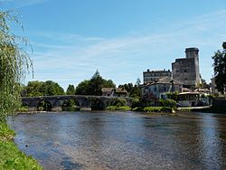 The old bridge over the Dronne, Bourdeilles
 Bridge over the Dronne, Aubeterre-sur-Dronne
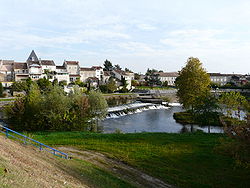 The Dronne at Coutras


.JPG)
Related pages
References
Other websites
Wikiwand - on
Seamless Wikipedia browsing. On steroids.
Remove ads