Council Grove, Kansas
city and county seat in Morris County, Kansas, United States From Wikipedia, the free encyclopedia
city and county seat in Morris County, Kansas, United States From Wikipedia, the free encyclopedia
Council Grove is a city in Morris County, Kansas, United States.[5] It is also the county seat of Morris County. This city is fifty-five miles southwest of Topeka. It was named after an agreement between European Americans and the Osage Nation about allowing settlers' wagon trains to go through the area to go West. Pioneers came together at a grove of trees so that wagons could stay together for their trip west. In 2020, 2,140 people lived there.[4]
Council Grove, Kansas | |
|---|---|
City and County seat | |
 Downtown Council Grove (2012) | |
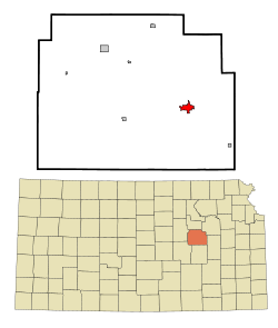
 Location within Morris County and Kansas | |
 | |
| Coordinates: 38°39′38″N 96°29′23″W[1] | |
| Country | United States |
| State | Kansas |
| County | Morris |
| Incorporated | 1887[2] |
| Government | |
| • Type | Mayor–Council |
| Area | |
| • Total | 2.21 sq mi (5.72 km2) |
| • Land | 2.14 sq mi (5.53 km2) |
| • Water | 0.07 sq mi (0.19 km2) |
| Elevation | 1,234 ft (376 m) |
| Population | |
| • Total | 2,140 |
| • Density | 970/sq mi (370/km2) |
| Time zone | UTC-6 (CST) |
| • Summer (DST) | UTC-5 (CDT) |
| ZIP codes | 66846, 66873 |
| Area code | 620 |
| FIPS code | 20-15925 [1] |
| GNIS ID | 477021 [1] |
| Website | cityofcouncilgrove.com |


Council Grove was one of the last stops on the Santa Fe Trail when going southwest. The first European-American settler was Seth M. Hays. He came to the area in 1847 to trade with the Kaw tribe. The Kaw had a reservation created in the area in 1846. Hays was a great grandson of Daniel Boone.[source?]
On February 26, 1855, a post office was created in Council Grove.[6]
In 1858, the town was officially incorporated by the Kansas legislature.[7] Hays also opened a restaurant in 1857, the Hays House, which is said to be the oldest restaurant west of the Mississippi River.
In 1943, the United States government brought prisoners to Lawrence. These prisoners were war prisoners from World War II. The prisoners were mostly German people and Italian people. The government brought them because farmers needed more people. They were forced to live in camps. These camps were like prisons. Fort Riley created 12 small camps, and one was in Council Grove.[8]
The United States Census Bureau says that the city has a total area of 2.21 square miles (5.72 km2). Of that, 2.14 square miles (5.54 km2) is land and 0.07 square miles (0.18 km2) is water.[3]
Council Grove has hot, humid summers and generally mild to cool winters. The Köppen Climate Classification system says that Council Grove has a humid subtropical climate, abbreviated "Cfa" on climate maps.[9]

The 2020 census says that there were 2,140 people, 912 households, and 528 families living in Council Grove. Of the households, 63.9% owned their home and 36.1% rented their home.
The median age was 41.3 years. Of the people, 90.9% were White, 0.3% were Native American, 0.2% were Black, 0.2% were Asian, 2.1% were from some other race, and 6.1% were two or more races. Hispanic or Latino of any race were 7.1% of the people.[4][10]
The 2010 census says that there were 2,182 people, 991 households, and 565 families living in Council Grove.[11]


Council Grove is part of Unified School District 417.[12][13]
Seamless Wikipedia browsing. On steroids.
Every time you click a link to Wikipedia, Wiktionary or Wikiquote in your browser's search results, it will show the modern Wikiwand interface.
Wikiwand extension is a five stars, simple, with minimum permission required to keep your browsing private, safe and transparent.