ගොනුව:Geostationaryjava3D.gif
From Wikipedia, the free encyclopedia
මෙයට ඉහල විසර්ජනයක් ලබාගත නොහැක.
Geostationaryjava3D.gif (220 × 220 පික්සල, ගොනු විශාලත්වය: 227 කි.බ., MIME ශෛලිය: image/gif, වලිත, 183 රාමු, 14තත්)
මෙම ගොනුව Wikimedia Commons වෙතින් වන අතර අනෙකුත් ව්යාපෘතීන් විසින්ද භාවිතා කල හැක. එහි ගොනු විස්තර පිටුව තුල අඩංගු විස්තර මෙහි පහත දැක්වෙයි.
සාරාංශය
| විස්තරයGeostationaryjava3D.gif |
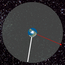
English: Top View of Geostationary orbit. To an observer on the rotating Earth (Africa on the Earth ), the satellite appears stationary in the sky as shown by the yellow radius. A red satellite is also geostationary above its own point on the Earth (Singapore)
http://weelookang.blogspot.com/2010/07/ejs-open-source-geostationary-satellite.html |
| දිනය | |
| මූලාශ්රය | ස්වයං නිර්මාණයකි |
| කර්තෘ | Lookang many thanks to author of original simulation = Francisco Esquembre author of Easy Java Simulation = Francisco Esquembre |
බලපත්රීකරණය
මෙම කෘතියෙහි හිමිකම් අයිතීන් දරන්නා වන මම,පහත වරපත යටතේ එය ප්රකාශයට පත් කරමි:
මෙම ගොනුව ක්රියේටිව් කොමන්ස් Attribution-Share Alike 3.0 Unported වරපත යටතේ අවසර ලබා ඇත.
- ඔබ නිදහස්:
- බෙදාහදා ගැනීමට – කාර්යය පිටපත් කිරීමට,බෙදා හැරීමට සහ සම්ප්රේෂණය කිරීමට
- නැවත සංකලනය කිරීමට – කාර්යයට අනුවර්තනය වීමට
- පහත කොන්දේසිවලට යටත්ව:
- attribution – වරපත වෙත බැඳියක්ද සපයමින් ඔබ විසින් සුදුසු කර්තෘභාරය ප්රදානය කල යුතු අතර, කිසියම් වෙනස්වීම් සිදුකලේ නම් එයද සඳහන් කල යුතු වෙයි. ඕනෑම සුදුසු ආකාරයට මෙය ඔබ විසින් සිදුකල හැකි මුත්, වරපත්දායකයා විසින් ඔබ හෝ ඔබගේ භාවිතය හෝ පිටසන් කරන බවට ඇඟවෙන ලෙසින් එය සිදු නොකල යුතු වෙයි.
- share alike – මෙම විෂය කාරණා භාවිතා කොට නැවත සංකලනය, ප්රතියෝජනය හෝ වැඩිදියුණුව කලේ නම්, ඉන්පසු ඔබගේ දායකත්වය ඔබ විසින් බෙදාහැරිය යුත්තේ මුල් වරපත හා සමාන හෝ සංගතික හෝ වරපතක් භාවිතා කරමිනි.
Captions
මෙම ගොනුව නිරූපණය කරන්නෙඑ කුමක්දැයි තනි පේළියේ පැහැදිළි කිරීමක් එක් කරන්න.
Top View of Geostationary orbit
Geosynchronous Orbit
ಸಾಗರದ ಮಟ್ಟದಿಂದ ೩೫೭೮೬ ಕಿಮೀ ಎತ್ತರದಲ್ಲಿ ಭೂಮಿಯನ್ನು ಸುತ್ತುವ ಭೂ ಸ್ಥಿರಪಥ ಉಪಗ್ರಹ
Items portrayed in this file
depicts ඉංග්රීසි
some value
copyright status ඉංග්රීසි
copyrighted ඉංග්රීසි
copyright license ඉංග්රීසි
inception ඉංග්රීසි
27 ජූනි 2011
source of file ඉංග්රීසි
original creation by uploader ඉංග්රීසි
media type ඉංග්රීසි
image/gif
ගොනු ඉතිහාසය
එම අවස්ථාවෙහිදී ගොනුව පැවැති ආකාරය නැරඹීමට දිනය/වේලාව මත ක්ලික් කරන්න.
| දිනය/වේලාව | කුඩා-රූපය | මාන | පරිශීලක | පරිකථනය | |
|---|---|---|---|---|---|
| වත්මන් | 02:45, 12 ජූනි 2013 | | 220 × 220 (227 කි.බ.) | Lookang | updated to 2013 version |
| 01:22, 27 ජූනි 2011 |  | 220 × 220 (480 කි.බ.) | Lookang | Geostationary orbit.To an observer on the rotating Earth (fixed point on the Earth), the satellite appears stationary in the sky. A red satellite is also geostationary above its own point on Earth. Top Down View | |
| 01:14, 27 ජූනි 2011 |  | 280 × 280 (677 කි.බ.) | Lookang | trying to make the thumbnail animated by using comtasia 7 | |
| 01:08, 27 ජූනි 2011 |  | 280 × 280 (624 කි.බ.) | Lookang | Geostationary orbit.To an observer on the rotating Earth (fixed point on the Earth), the satellite appears stationary in the sky. A red satellite is also geostationary above its own point on Earth. Top Down View | |
| 01:06, 27 ජූනි 2011 |  | 300 × 300 (625 කි.බ.) | Lookang | Geostationary orbit.To an observer on the rotating Earth (fixed point on the Earth), the satellite appears stationary in the sky. A red satellite is also geostationary above its own point on Earth. Top Down View. | |
| 00:57, 27 ජූනි 2011 |  | 300 × 300 (653 කි.බ.) | Lookang |
ගොනු භාවිතය
පහත දැක්වෙන පිටුව විසින් මෙම ගොනුව භාවිතා කෙරෙයි:
ගෝලීය ගොනු භාවිතය
පහත දැක්වෙන අනෙකුත් විකියන් මගින් මෙම ගොනුව භාවිතා කරයි:
- af.wikipedia.org හි භාවිතය
- an.wikipedia.org හි භාවිතය
- ar.wikipedia.org හි භාවිතය
- ast.wikipedia.org හි භාවිතය
- bn.wikipedia.org හි භාවිතය
- bs.wikipedia.org හි භාවිතය
- ca.wikipedia.org හි භාවිතය
- en.wikipedia.org හි භාවිතය
- es.wikipedia.org හි භාවිතය
- et.wikipedia.org හි භාවිතය
- fa.wikipedia.org හි භාවිතය
- gl.wikipedia.org හි භාවිතය
- he.wikipedia.org හි භාවිතය
- hi.wikipedia.org හි භාවිතය
- hr.wikipedia.org හි භාවිතය
- hu.wikipedia.org හි භාවිතය
- hy.wikipedia.org හි භාවිතය
- io.wikipedia.org හි භාවිතය
- kn.wikipedia.org හි භාවිතය
- ml.wikipedia.org හි භාවිතය
- ms.wikipedia.org හි භාවිතය
- pl.wikipedia.org හි භාවිතය
- pnb.wikipedia.org හි භාවිතය
- pt.wikipedia.org හි භාවිතය
- ru.wikipedia.org හි භාවිතය
- ru.wikinews.org හි භාවිතය
- simple.wikipedia.org හි භාවිතය
- sl.wikipedia.org හි භාවිතය
- sr.wikipedia.org හි භාවිතය
- ta.wikipedia.org හි භාවිතය
- te.wikipedia.org හි භාවිතය
- tg.wikipedia.org හි භාවිතය
- th.wikipedia.org හි භාවිතය
- ur.wikipedia.org හි භාවිතය
- vi.wikipedia.org හි භාවිතය
- www.wikidata.org හි භාවිතය
- zh-yue.wikipedia.org හි භාවිතය
- zh.wikipedia.org හි භාවිතය
පාරදත්ත
සමහරවිට ඩිජිටල් කැමරාවක් හෝ ස්කෑනරයක් හෝ භාවිතයෙන්, නිමැවා හෝ සංඛ්යාංකකරණය (ඩිජිටල්කරණය) කොට එක් කල , අමතර තොරතුරු මෙම ගොනුවේ අඩංගුය.
ගොනුව මුලින්ම පැවැති තත්ත්වයෙහි සිට විකරණය කොට තිබේ නම්, සමහරක් තොරතුරු විකරිත ගොනුව පූර්ණ වශයෙන් පිළිඹිමු නොකරනු ඇත.
| GIF ගොනු නිදර්ශනය | Title: geostationaryjava3d2013 Author: lookang |
|---|
"https://si.wikipedia.org/wiki/ගොනුව:Geostationaryjava3D.gif" වෙතින් සම්ප්රවේශනය කෙරිණි