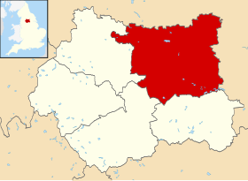
City of Leeds (čita se Siti of Lids) je grad i distrikt od 774,060 stanovnika[1] sa statusom metropolitanskog borougha na sjeveru Engleske u Grofoviji West Yorkshire.
City of Leeds | |
|---|---|
| Koordinate: 53°47′N 1°32′W | |
| država | |
| Regija | Yorkshire i Humber |
| Ceremonijalna grofovija | West Yorkshire |
| Površina | |
| - Ukupna | 551.72 km²[1] |
| Stanovništvo (2014.) | |
| - Grad | 774,060[1] |
| - Gustoća | 1,403 sta./km²[1] |
| Vremenska zona | UTC+0 (UTC+1) |
| Karta | |
 | |
Ime je dobio po najvećem gradu distrikta i administrativnom centru Leedsu, pored njega veći gradovi su; Farsley, Garforth, Guiseley, Horsforth, Morley, Otley, Pudsey, Rothwell, Wetherby i Yeadon.[2]
Geografske karakteristike
City of Leeds leži duž rijeke Aire, udaljen četrdesetak km sjevroistočno od Manchestera.[2]
Historija
Distrikt City of Leeds osnovan je 1. aprila 1974. pod nazivom - City and County Borough of Leeds, nakon donošenja zakona o lokalnoj upravi 1972.
Pobratimski gradovi
Izvori
Vanjske veze
Wikiwand in your browser!
Seamless Wikipedia browsing. On steroids.
Every time you click a link to Wikipedia, Wiktionary or Wikiquote in your browser's search results, it will show the modern Wikiwand interface.
Wikiwand extension is a five stars, simple, with minimum permission required to keep your browsing private, safe and transparent.

