Αρχείον:Map_Bih_entities.png
From Wikipedia, the free encyclopedia
Μέγεθος αυτής της προεπισκόπησης: 633 × 599 εικονοστοιχεία . Άλλες αναλύσεις: 254 × 240 εικονοστοιχεία | 507 × 480 εικονοστοιχεία | 811 × 768 εικονοστοιχεία | 1.103 × 1.044 εικονοστοιχεία.
Τζιπ τρανόν ανάλυση (1.103 × 1.044 εικονοστοιχεία, μέγεθος αρχείου: 67 KB, MIME τύπον: image/png)
Αούτον τ' αρχείον εφορτώθεν ασό Wikimedia Commons κι επορούν και κουλανεύν'ατο σ' άλλα έργα. Το γράψιμον κιαλλ'αφκά αση file description page ατ' εν κι εξηγίζ'ατο.
Σύνοψη
| ΣχόλιονMap Bih entities.png |
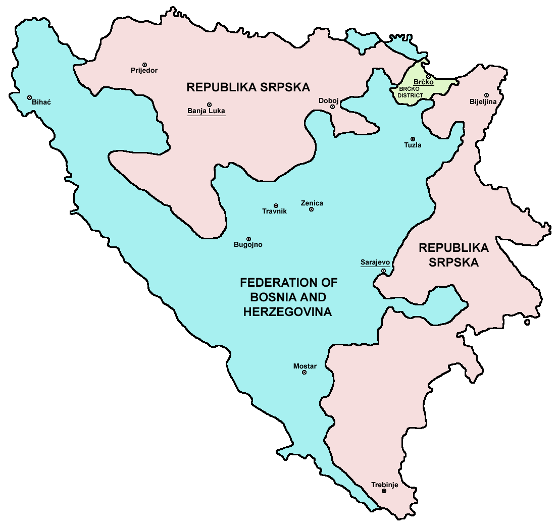
Srpskohrvatski / српскохрватски: Federacija Bosne i Hercegovine, Republika Srpska i Distrikt Brčko / Федерација Босне и Херцеговине, Република Српска и Дистрикт Брчко. |
| Ημερομηνία | |
| Πηγήν | en:Image:M_bih03.png |
| Δημιουργός | User:PANONIAN |
| άλλες εκδόσεις |
[άλλαξον]
|


.png)


References
- Slobodan Radovanović, Geografski atlas, Magic Map, Smederevska Palanka, 2001.
- Geografski atlas, Intersistem kartografija, Beograd, 2004.
- http://www.mapsofworld.com/bosnia/maps/bosnia-herzegovina-map.jpg
- http://www.slobodanjovanovic.org/wp-content/uploads/2009/12/bosna-kantoni1.jpg
- http://www.thomasgraz.net/glass/map-BIH.gif
- http://aceproject.org/ero-en/regions/europe/BA/doc1.jpg/image
- United States Department of State
- http://www.visitbosnia.org/bih/images/stories/o_bih/drzavno_uredjenje/entiteti.jpg[dead link]
- http://www.conflictgeographies.org/uploads/2/6/1/8/2618869/8958714.jpg?490 archive copy at the Wayback Machine
- http://vozi.org/images/stories/broj%20registrovanih%20vozila%202010.godina.png
- http://www.ohr.int/ohr-offices/brcko/images/map-brcko-district.jpg
- http://www.ohr.int/ohr-offices/brcko/images/mapa%20BD.JPG
- http://www.conflictgeographies.org/uploads/2/6/1/8/2618869/388168.jpg?490 archive copy at the Wayback Machine
- http://world-gazetteer.com/ archive copy at the Wayback Machine
Αδειοδότηση
| Public domainPublic domainfalsefalse |
| Εγώ, ο κάτοχος των πνευματικών δικαιωμάτων αυτού του έργου, δημοσιεύω αυτό το έργο ως κοινό κτήμα. Αυτό ισχύει σε παγκόσμια κλίμακα. Σε ορισμένες χώρες αυτό μπορεί να μην είναι νομικά εφικτό. Αν ναι: Παραχωρώ σε οποιονδήποτε το δικαίωμα να χρησιμοποιήσει αυτό το έργο "για οποιονδήποτε σκοπό", χωρίς κανέναν όρο, εκτός και αν τέτοιοι όροι τίθενται από την νομοθεσία |

|
This map image could be re-created using vector graphics as an SVG file. This has several advantages; see Commons:Media for cleanup for more information. If an SVG form of this image is available, please upload it and afterwards replace this template with
{{vector version available|new image name}}.
It is recommended to name the SVG file “Map Bih entities.svg”—then the template Vector version available (or Vva) does not need the new image name parameter. |
Λεζάντες
Δεν ορίστηκε λεζάντα
Items portrayed in this file
απεικονίζει Ελληνικά
άδεια χρήσης Ελληνικά
ημερομηνία ίδρυσης ή δημιουργίας Ελληνικά
28 Καλανταρί 2006
τύπος αρχείου Ελληνικά
image/png
Ιστορικόν τ' αρχείου
Εφτάτε κλικ σ' έναν ημερομηνίαν/ώραν απάν αέτς για να τερείτε πως έτον τ' αρχείον σ' εκείνεν την ώραν.
| Ώραν/Ημερομ. | Εικονιδίον | Διαστάσεις | Χρήστες | Σχόλιον | |
|---|---|---|---|---|---|
| υστερινά | 21:38, 6 Χορτοθερί 2010 | | 1.103 × 1.044 (67 KB) | PANONIAN | Reverted to version as of 23:51, 12 March 2010 - I do not agree that these are better colours. it is subjective opinion and it is bad idea that every user should upload new file version because he have different opinion about "better" colours |
| 12:26, 6 Χορτοθερί 2010 |  | 1.103 × 1.044 (58 KB) | Mostarac | better colors | |
| 12:25, 6 Χορτοθερί 2010 |  | 1.103 × 1.044 (58 KB) | Mostarac | better colors and cities. | |
| 23:51, 12 Μαρτ 2010 |  | 1.103 × 1.044 (67 KB) | Dungodung | Well, I beg to differ. This one shows cities and is of better quality | |
| 11:55, 9 Μαρτ 2010 |  | 700 × 615 (172 KB) | Mostarac | revert, bolje boje! | |
| 21:10, 20 Χριστουγενναρί 2009 |  | 1.103 × 1.044 (67 KB) | PANONIAN | improved version | |
| 08:05, 16 Χορτοθερί 2007 |  | 700 × 615 (13 KB) | Nihad Hamzic | This image was once a JPEG, the author had simply directly converted it to JPEG. I have grealty optimised its size by removing JPEG artifacts, and reducing color domain. | |
| 22:42, 28 Καλανταρί 2006 |  | 700 × 615 (172 KB) | (:Julien:) | Map of the 2 entities of the BiH and the Brčko district, author: en:User:PANONIAN, source: en:Image:M_bih03.png, PANONIAN is the creator and released it under PD. Category:Bosnia and Herzegovina |
Συνδέσμ αρχείων
Ατά τα σελίδαν δεκνίζ' σην εικόναν:
Καθολική χρήση αρχείου
Τα ακόλουθα άλλα wiki χρησιμοποιούν αυτό το αρχείο:
- Χρήση σε af.wikipedia.org
- Χρήση σε ami.wikipedia.org
- Χρήση σε am.wikipedia.org
- Χρήση σε arc.wikipedia.org
- Χρήση σε ar.wikipedia.org
- Χρήση σε arz.wikipedia.org
- Χρήση σε ast.wikipedia.org
- Χρήση σε az.wikipedia.org
- Χρήση σε bat-smg.wikipedia.org
- Χρήση σε be-tarask.wikipedia.org
- Χρήση σε bi.wikipedia.org
- Χρήση σε bjn.wikipedia.org
- Χρήση σε bn.wikipedia.org
- Χρήση σε bo.wikipedia.org
- Χρήση σε bpy.wikipedia.org
- Χρήση σε br.wikipedia.org
- Χρήση σε bs.wikipedia.org
- Χρήση σε ca.wikipedia.org
- Χρήση σε ceb.wikipedia.org
- Χρήση σε ce.wikipedia.org
- Χρήση σε ckb.wikipedia.org
- Χρήση σε co.wikipedia.org
- Χρήση σε crh.wikipedia.org
- Χρήση σε csb.wikipedia.org
- Χρήση σε cs.wikipedia.org
- Χρήση σε cs.wikinews.org
- Χρήση σε cv.wikipedia.org
- Χρήση σε cy.wikipedia.org
- Χρήση σε da.wikipedia.org
- Χρήση σε de.wikipedia.org
- Χρήση σε diq.wikipedia.org
- Χρήση σε dv.wikipedia.org
- Χρήση σε ee.wikipedia.org
- Χρήση σε el.wikipedia.org
- Χρήση σε en.wikipedia.org
- Bosnia and Herzegovina
- History of Bosnia and Herzegovina
- Multinational state
- Republika Srpska (1992–1995)
- Inter-Entity Boundary Line
- Talk:Inter-Entity Boundary Line
- Portal:Bosnia and Herzegovina
- User:Jonny-mt/Gallery of current first-level administrative country subdivisions maps
- Politics of country subdivisions
- Talk:Federation of Bosnia and Herzegovina/Archive 1
- User:Falcaorib/Serbia, Yugoslavia and Albania
Δείτε περισσότερη καθολική χρήση αυτού του αρχείου.