File:Map_provinces_Netherlands-en.svg
From Wikipedia, the free encyclopedia

Size of this PNG preview of this SVG file: 506 × 600 pixels. Otro resolushon: 202 × 240 pixels | 405 × 480 pixels | 648 × 768 pixels | 864 × 1,024 pixels | 1,727 × 2,048 pixels | 743 × 881 pixels.
Fail original (Fail SVG, nominalmente 743x881 pixel, tamaño di fail: 1,003 KB)
E fail akí ta di Wikimedia Commons i por us'é den otro proyekto. E deskripshon riba su página di deskripshon di fail ta indiká mas abou.
This W3C-unspecified vector image was created with Inkscape .
| This SVG file contains embedded text that can be translated into your language, using any capable SVG editor, text editor or the SVG Translate tool. For more information see: About translating SVG files. |
Resúmen
| DeskripshonMap provinces Netherlands-en.svg |
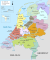
English: Map of The Netherlands (including the special municipalities of Saba, Saint Eustatius and Bonaire; the Caribbean Netherlands), showing provinces, large cities, rivers and lakes. English version
Deutsch: Karte der Niederlande, mit den Provinzen, der Karibischen Niederlande, den Großstädten und den Flüssen und Seen. Englische Version
Bahasa Indonesia: Peta Belanda (termasuk munisipal khusus Saba, Saint Eustatius dan Bonaire; Belanda Karibia), menampilkan provinsi, kota besar, sungai dan danau. Versi bahasa Inggris |
| Fecha | |
| Fuente | Obra propio |
| Outor | Alphathon |
| Other versions |
[editá]
|


.svg)
Lisensia
I, the copyright holder of this work, hereby publish it under the following licenses:
E fail akí tin lisensia Creative Commons Attribution-Share Alike 3.0 Unported.
- Bo ta liber:
- pa kompartí – pa kopia, distribuí i transmití e obra
- pa rekombiná – pa adaptá e obra
- Di akuerdo ku e próksimo kondishonnan:
- atribushon – Bo mester duna krédito na e outor, duna un lenk na e lisensia, i indiká si a hasi kambio. Bo por hasi esei na kualke manera rasonabel, perono na manera ku por sugerí ku esun ku ta otorgá e lisensia ta respaldá abo òf bo uzo.
- kompartí meskos – Si bo meskla, transfrmáòf modifiká e obra bo mester distribuí bo kontribushonnan bou di [mes lisensia https://creativecommons.org/share-your-work/licensing-considerations/compatible-licenses òf unu kompatibel] ku esun original.

|
Ta pèrmití kopia, distribuí i/òf modifiká e dokumento akí segun e GNU Free Documentation License, Vershon 1.2 òf kualke vershon mas resien publiká pa Free Software Foundation; sin Sekshon Invariante, sin teksto Front-Cover, i sin teksto Back-Cover. Un ehemplar di e lisensia ta inkluí den e sekshon yamá Lisensia di Dokumentashon Liber GNU.http://www.gnu.org/copyleft/fdl.htmlGFDLGNU Free Documentation Licensetruetrue |
Bo por skohe e lisensia preferí.
Captions
Add a one-line explanation of what this file represents
Items portrayed in this file
ta portretá
some value
29 ougùstùs 2010
source of file ingles
media type ingles
image/svg+xml
Historia di fail
Klek riba un fecha/ora pa mira e fail, manera e tabata na e momentu ei.
| Fecha/Ora | Miniatura | Dimenshonnan | Usuario | Komentario | |
|---|---|---|---|---|---|
| aktual | 19:28, 19 yanüari 2024 | | 743 × 881 (1,003 KB) | Illchy | File uploaded using svgtranslate tool (https://svgtranslate.toolforge.org/). Added translation for id. |
| 17:43, 29 aprel 2023 |  | 743 × 881 (987 KB) | Dymitr | File uploaded using svgtranslate tool (https://svgtranslate.toolforge.org/). Added translation for be-tarask. | |
| 09:27, 25 novèmber 2021 |  | 743 × 881 (909 KB) | Andrei Stroe | File uploaded using svgtranslate tool (https://svgtranslate.toolforge.org/). Added translation for ro. | |
| 08:39, 12 aprel 2019 |  | 743 × 881 (811 KB) | Thayts | Tweaked text position | |
| 11:32, 17 febrüari 2019 |  | 743 × 881 (811 KB) | Thayts | Fixed svg | |
| 11:18, 17 febrüari 2019 |  | 743 × 881 (811 KB) | Thayts | Added a bit more spacing between Eastern/Western and Scheldt | |
| 11:06, 17 febrüari 2019 |  | 743 × 881 (811 KB) | Thayts | Fixed Eastern Scheldt which wasn't rendered by the MediaWiki engine; removed Belgian city of Antwerp | |
| 05:21, 14 febrüari 2019 |  | 743 × 881 (809 KB) | Alphathon | Updated borders | |
| 20:34, 23 ougùstùs 2015 |  | 743 × 881 (847 KB) | Alphathon | Fixed stroke weight on a Friesland lake | |
| 20:27, 23 ougùstùs 2015 |  | 743 × 881 (847 KB) | Alphathon | Covered over the strokes at the mouths of rivers |
Uso di fail
E próksimo page uses ta uza e fail akí:
Uso global di fail
E próksimo otro wikinan ta usa e fail akí
- Uso na ace.wikipedia.org
- Uso na af.wikipedia.org
- Uso na ang.wikipedia.org
- Uso na an.wikipedia.org
- Uso na ar.wikipedia.org
- Uso na ay.wikipedia.org
- Uso na azb.wikipedia.org
- Uso na be-tarask.wikipedia.org
- Uso na bg.wikipedia.org
- Uso na blk.wikipedia.org
- Uso na bn.wikipedia.org
- Uso na ceb.wikipedia.org
- Uso na diq.wikipedia.org
- Uso na en.wikipedia.org
- Netherlands
- Provinces of the Netherlands
- List of islands of the Netherlands
- King's commissioner
- Geology of the Netherlands
- File talk:Netherlands map large.png
- French war planning 1920–1940
- User talk:Gidonb/Archive 2008
- Template:Provinces of the Netherlands imagemap
- List of windmills in the Netherlands
- Provincial politics in the Netherlands
- 2008–09 KNVB Cup
- User:Alphathon/Gallery
- Portal:Islands
- Wikipedia:Reference desk/Archives/Humanities/2014 September 25
- Uso na en.wikiversity.org
- Uso na eu.wikipedia.org
- Uso na fa.wikipedia.org
- Uso na fi.wikipedia.org
- Uso na fr.wikipedia.org
- Uso na gl.wikipedia.org
- Uso na haw.wikipedia.org
- Uso na he.wikipedia.org
- Uso na ia.wikipedia.org
- Uso na id.wikipedia.org
Mira mas uzo global di e fail akí.
Metadato
E fail akí tin informashon adishonal, probablemente añadí for di e kámara òf skèner ku a uza pa digitalis'é.
Si a kambia e fail di su estado original, por ta sierto detayenan no ta reflehá e fail kambiá.
| Width | 743 |
|---|---|
| Height | 881 |