Bestand:Mapcarpat2.png
Uit Wikipedia, de vrije encyclopedia
Geen hogere resolutie beschikbaar.
Mapcarpat2.png (442 × 395 pixels, bestandsgrootte: 11 kB, MIME-type: image/png)
Dit is een bestand van Wikimedia Commons.
Onderstaande beschrijving komt van de beschrijving van het bestand daar.
Onderstaande beschrijving komt van de beschrijving van het bestand daar.
Beschrijving
| BeschrijvingMapcarpat2.png |
Dansk: Opdelingen af Karpaterne i sorte tal:
Floder i små blå bogstaver:
Lande (ISO 3166-1 alpha-2 codes), i røde kapitæler:
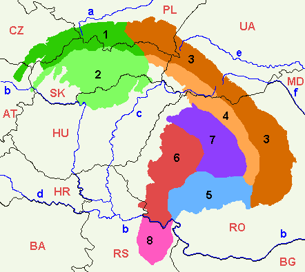
English: 1=Outer Western Carpathians, 2=Inner Western Carpathians, 3=Outer Eastern Carpathians, 4=Inner Eastern Carpathians, 5=Southern Carpathians or Transylvanian Alps, 6=Romanian Western Carpathians, 7=Transylvanian Plateau, 8=Serbian Carpathians. |
| Datum | |
| Bron | Eigen werk |
| Auteur | :en:Markussep |
| Andere versies | Mapcarpat.png |

|
Toestemming wordt verleend voor het kopiëren, verspreiden en/of wijzigen van dit document onder de voorwaarden van de GNU-licentie voor vrije documentatie, versie 1.2 of enige latere versie als gepubliceerd door de Free Software Foundation; zonder Invariant Sections, zonder Front-Cover Texts, en zonder Back-Cover Texts. Een kopie van de licentie is opgenomen in de sectie GNU-licentie voor vrije documentatie.http://www.gnu.org/copyleft/fdl.htmlGFDLGNU Free Documentation Licensetruetrue |
| Dit bestand is gelicenseerd onder de Creative Commons-licentie Naamsvermelding-Gelijk delen 3.0 Unported | ||
| ||
| Deze licentietag is toegevoegd aan dit bestand in verband met de GFDL licentie-update.http://creativecommons.org/licenses/by-sa/3.0/CC BY-SA 3.0Creative Commons Attribution-Share Alike 3.0truetrue |
Bijschriften
Beschrijf in één regel wat dit bestand voorstelt
1=Зовнішні Західні Карпати, 2=Внутрішні Західні Карпати, 3=Зовнішні Східні Карпати, 4=Внутрішні Східні Карпати, 5=Південні Карпати або Трансільванські Альпи, 6=Румунські Західні Карпати, 7=Трансільванське плато, 8=Сербські Карпати.
Items getoond in dit bestand
beeldt af
12 jul 2005
Bestandsgeschiedenis
Klik op een datum/tijd om het bestand te zien zoals het destijds was.
| Datum/tijd | Miniatuur | Afmetingen | Gebruiker | Opmerking | |
|---|---|---|---|---|---|
| huidige versie | 7 apr 2021 19:58 | | 442 × 395 (11 kB) | Keyacom | Changes: BH -> BA, fixed font for MD |
| 7 apr 2021 19:56 |  | 442 × 395 (11 kB) | Keyacom | Reverted to version as of 17:45, 6 January 2019 (UTC) cuz forgot to specify the actual changes | |
| 7 apr 2021 19:52 |  | 442 × 395 (11 kB) | Keyacom | changes: | |
| 6 jan 2019 19:45 |  | 442 × 395 (11 kB) | Julieta39 | Add MD | |
| 1 feb 2014 02:10 |  | 442 × 395 (12 kB) | Olahus | Small changes on Austria, Romania and Serbia. | |
| 24 mei 2007 10:23 |  | 442 × 395 (12 kB) | Zeman | {{Information |Description= |Source=self-made |Date= |Author= User:Zeman }} | |
| 12 jul 2005 13:52 |  | 442 × 395 (9 kB) | Markussep | ISO 3166-1 alpha-2 country codes | |
| 12 jul 2005 13:32 |  | 442 × 395 (9 kB) | Markussep | Annotated version of image file Mapcarpat.png |
Bestandsgebruik
Dit bestand wordt op de volgende pagina gebruikt:
Globaal bestandsgebruik
De volgende andere wiki's gebruiken dit bestand:
- Gebruikt op als.wikipedia.org
- Gebruikt op ar.wikipedia.org
- Gebruikt op arz.wikipedia.org
- Gebruikt op ast.wikipedia.org
- Gebruikt op ba.wikipedia.org
- Gebruikt op be-tarask.wikipedia.org
- Gebruikt op be.wikipedia.org
- Gebruikt op bg.wikipedia.org
- Gebruikt op bn.wikipedia.org
- Gebruikt op bs.wikipedia.org
- Gebruikt op ca.wikipedia.org
- Gebruikt op cs.wikipedia.org
- Gebruikt op da.wikipedia.org
- Gebruikt op de.wikipedia.org
- Gebruikt op de.wiktionary.org
- Gebruikt op el.wikipedia.org
- Gebruikt op en.wikipedia.org
- Central Europe
- Carpathian Mountains
- Bucegi Mountains
- Outer Subcarpathia
- Southern Carpathians
- Apuseni Mountains
- Divisions of the Carpathians
- Talk:Divisions of the Carpathians
- Transylvanian Plateau
- Slovak Ore Mountains
- Retezat-Godeanu Mountains group
- Parâng Mountains group
- Făgăraș Mountains group
- Western Carpathians
- North Hungarian Mountains
- Northern Maramureș
- Talk:Northern Maramureș
- Eastern section of the Western Beskids
- Template:Inner North-Eastern Carpathians
Globaal gebruik van dit bestand bekijken.
Metadata
Dit bestand bevat metadata met EXIF-informatie, die door een fotocamera, scanner of fotobewerkingsprogramma toegevoegd kan zijn.
| Horizontale resolutie | 28,35 dpc |
|---|---|
| Verticale resolutie | 28,35 dpc |
Overgenomen van "https://nl.wikipedia.org/wiki/Bestand:Mapcarpat2.png"