चित्र:Pallava_territories.png
From Wikipedia, the free encyclopedia
उच्च रिजोल्युशन अनुपलब्ध
Pallava_territories.png (२७० × १४३ पिक्सेलहरू, फाइल आकार: ९ किलोबाइटहरू, MIME प्रकार: image/png)
| यो विकिमीडिया कमन्सको चित्र हो। त्यहाँ यसको विवरण पृष्ठबाट जानकारी तल देखाइएको छ। कमन्स स्वतन्त्र रूपमा इजाजतपत्र प्राप्त चित्र भण्डार हो। तपाईंले मद्दत गर्न सक्नुहुन्छ। |
सारांश

|
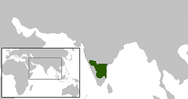
This map has been uploaded by Electionworld from en.wikipedia.org to enable the |
Pallava territories during Narasimhavarman I c. 645 CE. This includes the Chalukya territories occupied by the Pallavas.
Map created using the Wikipedia blank maps and modified using Adobe Photoshop
map shown here cotradicts the map shown in calukya period webpage. please retain yhe one which is historically accurate
अनुज्ञा प्राप्त गर्दै
Venu62, the copyright holder of this work, hereby publishes it under the following license:

|
यस दस्तावेजलाई स्वतन्त्र सफ्टवायर फाउन्डेसन द्वारा प्रकाशित जी॰एन॰यू फ्रि डक्यूमेन्टेशन लाइसेन्स को संस्करण 1.2 वा नयाँ (बिना कुनै इन्वेरियेन्ट अनुभाग र पछिल्लो वा पहिलो आवरणका पाठका) को अन्तर्गत कपी, वितरित एवं/अथवा परिवर्तित गर्ने अनुमति प्रदान गरिन्छ । यस लाइसेन्सको एक प्रति जी॰एन॰यू फ्रि डक्यूमेन्टेशन लाइसेन्स नामक अनुभागमा शामिल छ ।http://www.gnu.org/copyleft/fdl.htmlGFDLGNU Free Documentation Licensetruetrue |
| यो फाइल क्रिएटिभ कमन्स एट्रिब्युसन-सेयर एलाइक ३.० अनपोर्टेड लाइसेन्स अनुसारको अनुमति प्राप्त छ। | ||
| एट्रिब्युसन: Venu62 | ||
| ||
| This licensing tag was added to this file as part of the GFDL licensing update.http://creativecommons.org/licenses/by-sa/3.0/CC BY-SA 3.0Creative Commons Attribution-Share Alike 3.0truetrue |
Captions
Add a one-line explanation of what this file represents
Items portrayed in this file
जनाउँछ
copyright status अङ्ग्रेजी
copyrighted अङ्ग्रेजी
फाइल इतिहास
मिति/समय मा क्लिक गरेर त्यससमयमा यो फाइल कस्तो थियो भनेर हेर्न सकिन्छ ।
| मिति/समय | छोटो चित्र | आकारहरू | प्रयोगकर्ता | टिप्पणी | |
|---|---|---|---|---|---|
| हालको | ०५:१४, १४ डिसेम्बर २००६ | | २७०×१४३ (९ किलोबाइटहरू) | Electionworld | {{ew|en|Venu62}} Pallava territories during Narasimhavarman I c. 645 CE. This includes the Chalukya territories occupied by the Pallavas. Map created using the Wikipedia blank maps and modified using Adobe Photoshop map shown here cotradicts the |
फाइल प्रयोग
यस फाइलमा निम्न 2 पृष्ठहरू जोडिन्छन्:
विश्वव्यापी फाइल प्रयोग
निम्न अन्य विकिहरूमा यस फाइलको प्रयोग:
- ar.wikipedia.org मा उपयोग
- as.wikipedia.org मा उपयोग
- bn.wikipedia.org मा उपयोग
- br.wikipedia.org मा उपयोग
- ca.wikipedia.org मा उपयोग
- de.wikipedia.org मा उपयोग
- en.wikipedia.org मा उपयोग
- es.wikipedia.org मा उपयोग
- eu.wikipedia.org मा उपयोग
- fa.wikipedia.org मा उपयोग
- fi.wikipedia.org मा उपयोग
- fr.wikipedia.org मा उपयोग
- hi.wikipedia.org मा उपयोग
- hr.wikipedia.org मा उपयोग
- hu.wikipedia.org मा उपयोग
- it.wikipedia.org मा उपयोग
- ja.wikipedia.org मा उपयोग
- ka.wikipedia.org मा उपयोग
- ko.wikipedia.org मा उपयोग
- lt.wikipedia.org मा उपयोग
- ml.wikipedia.org मा उपयोग
- ms.wikipedia.org मा उपयोग
- nl.wikipedia.org मा उपयोग
- nn.wikipedia.org मा उपयोग
- no.wikipedia.org मा उपयोग
- oc.wikipedia.org मा उपयोग
- pl.wikipedia.org मा उपयोग
- pnb.wikipedia.org मा उपयोग
- pt.wikipedia.org मा उपयोग
- ru.wikipedia.org मा उपयोग
- sh.wikipedia.org मा उपयोग
- sq.wikipedia.org मा उपयोग
- ta.wikipedia.org मा उपयोग
- ta.wiktionary.org मा उपयोग
- te.wikipedia.org मा उपयोग
- uk.wikipedia.org मा उपयोग
यस फाइलको विश्वव्यापी उपयोगको अधिक जानकारी हेर्नुहोस् ।
"https://ne.wikipedia.org/wiki/चित्र:Pallava_territories.png" बाट अनुप्रेषित