चित्र:Bl-map.png
From Wikipedia, the free encyclopedia
Bl-map.png (३२७ × ३५० पिक्सेल, संचिकेचा आकार: १२ कि.बा., MIME प्रकार: image/png)
ही संचिका Wikimedia Commons येथील असून ती इतर प्रकल्पात वापरलेली असू शकते. तिचे तेथील संचिका वर्णन पान खाली दाखवले आहे.

|
This locator map image could be re-created using vector graphics as an SVG file. This has several advantages; see Commons:Media for cleanup for more information. If an SVG form of this image is available, please upload it and afterwards replace this template with
{{vector version available|new image name}}.
It is recommended to name the SVG file “Bl-map.svg”—then the template Vector version available (or Vva) does not need the new image name parameter. |
सारांश
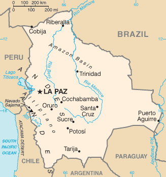
| वर्णनBl-map.png | Bolivia map from CIA World Factbook (since जून २, इ.स. २००४), converted from original GIF format |
| दिनांक | |
| स्रोत |
CIA World Factbook |
| लेखक | United States Central Intelligence Agency |
| इतर आवृत्तींस |
परवाना:
| Public domainPublic domainfalsefalse |
This image is in the public domain because it contains materials that originally came from the United States Central Intelligence Agency's World Factbook.
Bahasa Indonesia ∙ čeština ∙ Deutsch ∙ eesti ∙ English ∙ español ∙ Esperanto ∙ français ∙ galego ∙ hrvatski ∙ italiano ∙ Nederlands ∙ norsk nynorsk ∙ polski ∙ português ∙ sicilianu ∙ slovenščina ∙ suomi ∙ Türkçe ∙ Zazaki ∙ беларуская (тарашкевіца) ∙ македонски ∙ русский ∙ српски / srpski ∙ українська ∙ ქართული ∙ বাংলা ∙ தமிழ் ∙ മലയാളം ∙ 한국어 ∙ 日本語 ∙ 中文 ∙ 中文(简体) ∙ 中文(繁體) ∙ العربية ∙ +/− |
 |
Derivative works
-
 Bl-map mk.png
македонски -
 Bolivie carte.gif
français -
 Bolivyaharita.jpg
Türkçe -
 Ka Bolivia-Map.png
ქართული


Captions
Items portrayed in this file
depicts इंग्रजी
२ जून 2004
image/png
checksum इंग्रजी
a9a81b224ef15e71f74968a044cbd2bba564d997
data size इंग्रजी
१२,४६४ byte
३५० चित्रपेशी
३२७ चित्रपेशी
संचिकेचा इतिहास
संचिकेची त्यावेळची आवृत्ती बघण्यासाठी त्या दिनांक/वेळेवर टिचकी द्या.
| दिनांक/वेळ | छोटे चित्र | आकार | सदस्य | प्रतिक्रीया | |
|---|---|---|---|---|---|
| सद्य | १४:४५, १७ जून २००८ | | ३२७ × ३५० (१२ कि.बा.) | Sevela.p | Remove black line on the left side |
| २३:२२, २७ फेब्रुवारी २००५ |  | ३२८ × ३५० (१२ कि.बा.) | Alfio | CIA map of Bolivia |
दुवे
खालील पाने या संचिकेला जोडली आहेत:
जागतिक संचिका उपयोग
संचिकाचे इतर विकिपीडियावरील वापरः
- af.wikipedia.org वरील उपयोग
- ar.wikipedia.org वरील उपयोग
- ast.wikipedia.org वरील उपयोग
- ay.wikipedia.org वरील उपयोग
- be.wikipedia.org वरील उपयोग
- bn.wikipedia.org वरील उपयोग
- bn.wikibooks.org वरील उपयोग
- bo.wikipedia.org वरील उपयोग
- ca.wikipedia.org वरील उपयोग
- cs.wikipedia.org वरील उपयोग
- da.wikipedia.org वरील उपयोग
- de.wikibooks.org वरील उपयोग
- de.wikinews.org वरील उपयोग
- dsb.wikipedia.org वरील उपयोग
- dz.wikipedia.org वरील उपयोग
- el.wikipedia.org वरील उपयोग
- en.wikipedia.org वरील उपयोग
- List of islands of South America
- Talk:Geography of Bolivia
- Outline of Bolivia
- Irrigation in Bolivia
- Water resources management in Bolivia
- Agriculture in Bolivia
- Module:Location map/data/Bolivia/doc
- Module:Location map/data/Bolivia
- User:Gonzalezmwalter/Bolivia and the International Monetary Fund
- User:Gonzalezmwalter/IMF Bolivia
- Bolivia and the International Monetary Fund
- 1984 Bolivian coup attempt
- en.wikibooks.org वरील उपयोग
- en.wikinews.org वरील उपयोग
- en.wikisource.org वरील उपयोग
- eo.wikipedia.org वरील उपयोग
या संचिकेचे अधिक वैश्विक उपयोग पहा