Plaetje:Mapcarpat2.png
From Wikipedia, the free encyclopedia
Gein hoeger resolutie besjikbaar.
Mapcarpat2.png ((442 × 395 pixel, besjtandsgruutde: 11 kB, MIME type: image/png))
Dit besjtandj kump van Wikimedia Commons en kin ouch in anger projekte gebroek waere. De pagina mit de besjtandjsbesjrieving wurt hiejónger weergegaeve.
Besjrieving
| BesjrievingMapcarpat2.png |
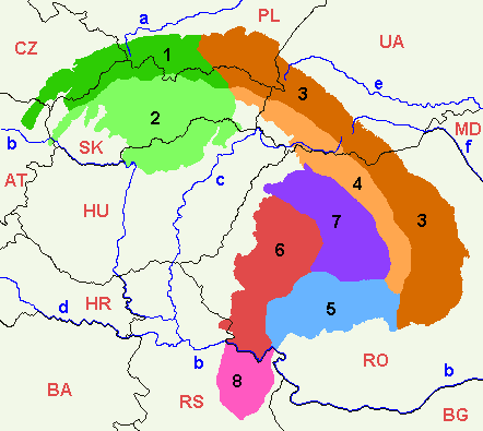
Dansk: Opdelingen af Karpaterne i sorte tal:
Floder i små blå bogstaver:
Lande (ISO 3166-1 alpha-2 codes), i røde kapitæler:
English: 1=Outer Western Carpathians, 2=Inner Western Carpathians, 3=Outer Eastern Carpathians, 4=Inner Eastern Carpathians, 5=Southern Carpathians or Transylvanian Alps, 6=Romanian Western Carpathians, 7=Transylvanian Plateau, 8=Serbian Carpathians. |
| Datum | |
| Brón | Eige werk |
| Sjriever | :en:Markussep |
| Anger versies | Mapcarpat.png |

|
Toesteumming wert verleend veur t kopiëre, verspreide en/of wiezige van dit document onger de veurwaerd van de GNU-licentie veur vrieje documentatie, versie 1.2 of einige latere versie es gepubliceerd door de Free Software Foundation; zonger Invariant Sections, zonger Front-Cover Texts, en zonger Back-Cover Texts. n kopie van de licentie is opgenomme in de sectie GNU-licentie veur vrieje documentatie.http://www.gnu.org/copyleft/fdl.htmlGFDLGNU Free Documentation Licensetruetrue |
| Dit bestandj steit gelicenseerdj óngere Creative Commons Attribution-Share Alike 3.0 Unported lisensje. | ||
| ||
| Dees licentie-tag woort tougevoeg aon dit bestand in verband mèt de GFDL licentie-update.http://creativecommons.org/licenses/by-sa/3.0/CC BY-SA 3.0Creative Commons Attribution-Share Alike 3.0truetrue |
Bijschriften
Beschrijf in één regel wat dit bestand voorstelt
1=Зовнішні Західні Карпати, 2=Внутрішні Західні Карпати, 3=Зовнішні Східні Карпати, 4=Внутрішні Східні Карпати, 5=Південні Карпати або Трансільванські Альпи, 6=Румунські Західні Карпати, 7=Трансільванське плато, 8=Сербські Карпати.
Items getoond in dit bestand
beeldt af Nederlands
auteursrechtenstatus Nederlands
auteursrechtelijk beschermd Nederlands
bron van bestand Nederlands
originele creatie door uploader Nederlands
datum van oprichting of creatie Nederlands
12 jul 2005
Besjtandshistorie
Klik op 'ne datum/tied óm 't besjtand te zeen wie 't oetzaog op det tiedsjtip.
| Datum/Tied | Miniatuurplaetje | Aafmaetinge | Gebroeker | Kómmentaar | |
|---|---|---|---|---|---|
| hujig | 7 apr 2021 19:58 | | 442 × 395 (11 kB) | Keyacom | Changes: BH -> BA, fixed font for MD |
| 7 apr 2021 19:56 |  | 442 × 395 (11 kB) | Keyacom | Reverted to version as of 17:45, 6 January 2019 (UTC) cuz forgot to specify the actual changes | |
| 7 apr 2021 19:52 |  | 442 × 395 (11 kB) | Keyacom | changes: | |
| 6 jan 2019 19:45 |  | 442 × 395 (11 kB) | Julieta39 | Add MD | |
| 1 fib 2014 02:10 |  | 442 × 395 (12 kB) | Olahus | Small changes on Austria, Romania and Serbia. | |
| 24 mei 2007 10:23 |  | 442 × 395 (12 kB) | Zeman | {{Information |Description= |Source=self-made |Date= |Author= User:Zeman }} | |
| 12 jul 2005 13:52 |  | 442 × 395 (9 kB) | Markussep | ISO 3166-1 alpha-2 country codes | |
| 12 jul 2005 13:32 |  | 442 × 395 (9 kB) | Markussep | Annotated version of image file Mapcarpat.png |
Plaetjesverwiezinge
Dit plaetje weurt op de volgende pazjena's gebroek:
Globaal besjtandjsgebroek
De volgende anger wiki's gebroeke dit bestandj:
- Gebroek in als.wikipedia.org
- Gebroek in ar.wikipedia.org
- Gebroek in arz.wikipedia.org
- Gebroek in ast.wikipedia.org
- Gebroek in ba.wikipedia.org
- Gebroek in be-tarask.wikipedia.org
- Gebroek in be.wikipedia.org
- Gebroek in bg.wikipedia.org
- Gebroek in bn.wikipedia.org
- Gebroek in bs.wikipedia.org
- Gebroek in ca.wikipedia.org
- Gebroek in cs.wikipedia.org
- Gebroek in da.wikipedia.org
- Gebroek in de.wikipedia.org
- Gebroek in de.wiktionary.org
- Gebroek in el.wikipedia.org
- Gebroek in en.wikipedia.org
- Central Europe
- Carpathian Mountains
- Bucegi Mountains
- Outer Subcarpathia
- Southern Carpathians
- Apuseni Mountains
- Divisions of the Carpathians
- Talk:Divisions of the Carpathians
- Transylvanian Plateau
- Slovak Ore Mountains
- Retezat-Godeanu Mountains group
- Parâng Mountains group
- Făgăraș Mountains group
- Western Carpathians
- North Hungarian Mountains
- Northern Maramureș
- Talk:Northern Maramureș
- Eastern section of the Western Beskids
- Template:Inner North-Eastern Carpathians
Bekiek wikiwied gebroek van dit bestandj.
Metadata
Dit besjtand bevat extra gegaeves, waorsjienlik door de digitale camera of scanner biegevoog. Es 't oersjprunkelik besjtand aangepas is, kin 't zeen dat sómmige details neet mie bie 't gewiezigde plaetje hure.
| Horizontaal resolutie | 28,35 dpc |
|---|---|
| Verticaal resolutie | 28,35 dpc |
Aafkomstig van Wikipedia, de Vriej Encyclopedie. "https://li.wikipedia.org/wiki/Plaetje:Mapcarpat2.png"