चित्र:Africa-regions.png
From Wikipedia, the free encyclopedia
इससे बड़ा रेसोल्यूशन उपलब्ध नहीं हैं।
Africa-regions.png ((360 × 392 पिक्सेल, फ़ाइल का आकार: 8 KB, MIME प्रकार: image/png))
|
|
यह फ़ाइल विकिमेडिया कॉमन्स से है। वहाँ पर इसका विवरण पृष्ठ निम्नोक्त है। कॉमन्स मुक्त लाइसेंसों के अंतर्गत उपलब्ध मीडिया फ़ाइलों का संग्रह है। आप भी इसमें मदद कर सकते हैं। |
सारांश
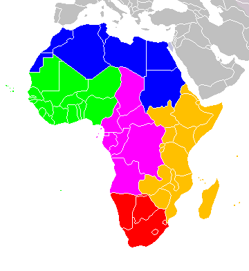
Africa: subregions as delineated by United Nations geographic classification scheme:
लाइसेंस
मैं, इस कार्य का/की कॉपीराइट धारक, इसे निम्न लाइसेंसों के अंतर्गत प्रकाशित करता/करती हूँ:

|
इस दस्तावेज़ को Free Software Foundation द्वारा प्रकाशित GNU मुक्त प्रलेख लाइसेंस के संस्करण 1.2 या नए (बिना किसी अपरिवर्तनीय अनुभागों और अगले या पिछले आवरण के टेक्स्ट के) के अंतर्गत प्रतिलिपि बनाने, बाँटने और/या बदलने की अनुमति प्रदान की जाती है। इस लाइसेंस की एक प्रतिलिपि GNU मुक्त प्रलेख लाइसेंस नामक अनुभाग में शामिल है।http://www.gnu.org/copyleft/fdl.htmlGFDLGNU Free Documentation Licensetruetrue |
| इस फ़ाइल को क्रिएटिव कॉमन्स श्रेय-समानसांझा 3.0 अनरिपोर्टेड लाइसेंस के अंतर्गत लाइसेंस किया गया है। | ||
| ||
| This licensing tag was added to this file as part of the GFDL licensing update.http://creativecommons.org/licenses/by-sa/3.0/CC BY-SA 3.0Creative Commons Attribution-Share Alike 3.0truetrue |
इस फ़ाइल को क्रिएटिव कॉमन्स श्रेय-समानसांझा 2.5 साधारण, 2.0 साधारण और 1.0 साधारण लाइसेंस के अंतर्गत लाइसेंस किया गया है।
- आप खुलकर:
- बाँट सकते हैं – रचना की प्रतिलिपि बना सकते हैं, बाँँट सकते हैं और संचारित कर सकते हैं
- रीमिक्स कर सकते हैं – कार्य को अनुकूलित कर सकते हैं
- निम्नलिखित शर्तों के अंतर्गत:
- श्रेय – यह अनिवार्य है कि आप यथोचित श्रेय प्रदान करें, लाइसेंस की कड़ी प्रदान करें, और अगर कोई बदलाव हुए हों तो उन्हें इंगित करें। आप ऐसा किसी भी उचित तरीके से कर सकते हैं, लेकिन किसी भी तरह उससे यह नहीं संकेत नहीं किया जाना चाहिए कि लाइसेंसधारी द्वारा आपको अथवा आपके इस प्रयोग का समर्थन किया जा रहा हो।
- समानसांझा – अगर आप इस रचना में कोई बदलाव करते हैं या इसपर आधारित कुछ रचित करते हैं तो आप अपने योगदान को सिर्फ इसी या इसके सामान किसी लाइसेंस के अंतर्गत बाँट सकते हैं।
आप अपना पसंद का लाइसेंस चुन सकते हैं।

|
File:Africa-regions.svg is a vector version of this file. It should be used in place of this PNG file when not inferior.
File:Africa-regions.png → File:Africa-regions.svg
For more information, see Help:SVG.
|
 |
Captions
Add a one-line explanation of what this file represents
Items portrayed in this file
चित्रण
media type अंग्रेज़ी
image/png
checksum अंग्रेज़ी
99e24847dfc7d308c007e19664bcafb5a4453b92
data size अंग्रेज़ी
७,९५९ बाइट
३९२ पिक्सल
width अंग्रेज़ी
३६० पिक्सल
चित्र का इतिहास
फ़ाइलका पुराना अवतरण देखने के लिये दिनांक/समय पर क्लिक करें।
| दिनांक/समय | थंबनेल | आकार | सदस्य | प्रतिक्रिया | |
|---|---|---|---|---|---|
| वर्तमान | 02:02, 1 जून 2018 | | 360 × 392 (8 KB) | Vesperius | Reverted to version as of 18:36, 28 May 2018 (UTC) (Most definitions of the regions include the Horn of Africa as part of East Africa, so I'm reverting this back) |
| 18:37, 28 मई 2018 |  | 360 × 392 (10 KB) | Vesperius | Reverted to version as of 18:25, 28 May 2018 (UTC) (Messed up, the purple indicating the Horn of Africa didn't show up for me) | |
| 18:36, 28 मई 2018 |  | 360 × 392 (8 KB) | Vesperius | Reverted to version as of 01:04, 16 May 2018 (UTC) | |
| 18:25, 28 मई 2018 |  | 360 × 392 (10 KB) | Vesperius | Reverted to version as of 18:57, 17 March 2018 (UTC) | |
| 01:04, 16 मई 2018 |  | 360 × 392 (8 KB) | Dwo | Reverted to version as of 08:22, 30 August 2015 (UTC) | |
| 18:57, 17 मार्च 2018 |  | 360 × 392 (10 KB) | Maphobbyist | Montenegro border | |
| 08:22, 30 अगस्त 2015 |  | 360 × 392 (8 KB) | Wiki-Zyron | Reverted to version as of 00:23, 20 December 2012 - Reverted to the last version before someone inexplicably moved Zimbabwe to Southern Africa. Eastern Africa is the correct region - [http://unstats.un.org/unsd/methods/m49/m49regin.htm#africa] | |
| 05:04, 21 अप्रैल 2015 |  | 360 × 392 (16 KB) | TAKASUGI Shinji | Corrected the color of Zimbabwe | |
| 15:16, 18 दिसम्बर 2014 |  | 360 × 392 (17 KB) | Hybscher | wrong colors | |
| 22:39, 22 नवम्बर 2014 |  | 2,000 × 2,050 (342 KB) | Andrew J.Kurbiko | pp |
चित्र का उपयोग
निम्नलिखित पन्ने इस चित्र से जुडते हैं :
चित्र का वैश्विक उपयोग
इस चित्र का उपयोग इन दूसरे विकियों में किया जाता है:
- anp.wikipedia.org पर उपयोग
- ar.wikipedia.org पर उपयोग
- arz.wikipedia.org पर उपयोग
- avk.wikipedia.org पर उपयोग
- azb.wikipedia.org पर उपयोग
- ba.wikipedia.org पर उपयोग
- bg.wikipedia.org पर उपयोग
- blk.wikipedia.org पर उपयोग
- bn.wikipedia.org पर उपयोग
- br.wikipedia.org पर उपयोग
- bxr.wikipedia.org पर उपयोग
- ca.wikipedia.org पर उपयोग
- de.wikipedia.org पर उपयोग
- el.wikipedia.org पर उपयोग
- en.wikipedia.org पर उपयोग
- Southern Africa
- Walvis Bay-Ndola-Lubumbashi Development Road
- N1 road (Gabon)
- User:R4000/Africa(Alt)
- Cairo Road
- User:ArminHammer
- User:Donbert/motherafrica
- User:Donbert/userboxes
- United Nations geoscheme
- United Nations geoscheme for Africa
- Rua Libertadores de África
- Lists of cities in Africa
- Portuguese Africans
- Sam Nujoma Street
- Cairo–Dakar Highway
- N'Djamena–Djibouti Highway
- Portal:Africa/Countries
- Portal:Africa/Countries/Map
- B8 road (Namibia)
- Template:Africa-road-stub
इस चित्र के वैश्विक उपयोग की अधिक जानकारी देखें।