File:Europe_1748-1766.png
From Wikipedia, the free encyclopedia
- Faidhle
- Eachdraidh an fhaidhle
- Cleachdadh an fhaidhle
- Cleachdadh fhaidhlichean uile-choitcheann
- Metadata
Am faidhle tùsail (3,872 × 2,761 pixel, meud an fhaidhle: 1.47 MB, seòrsa MIME: image/png)
'S ann à Wikimedia Commons a tha am faidhle seo agus faodaidh gu bheil pròiseactan eile 'ga chleachdadh. Chì thu an tuairisgeul a tha aice air [duilleag tuairisgeul an fhaidhle https://commons.wikimedia.org/wiki/File:Europe_1748-1766.png] gu h-ìosal.
Gearr-chunntas
| TuairisgeulEurope 1748-1766.png |
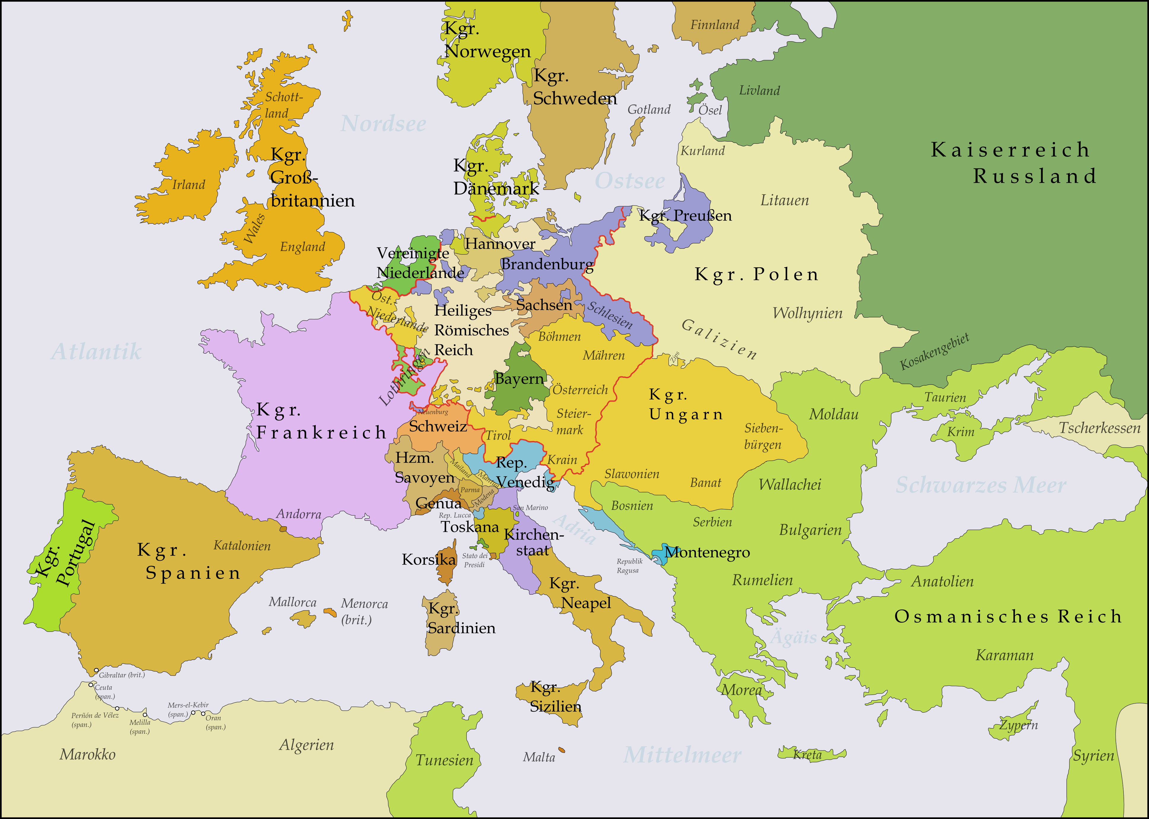
Deutsch: Diese Karte zeigt Europa in den Jahren nach dem Frieden von Aachen 1748 und in der Zeit des Siebenjährigen Krieges (1756-1763). Bis 1766 kam es zu keinen größeren geographischen Veränderungen in Europa.
Die Arbeit wurde mit Inkscape erstellt und beruht hauptsächlich auf einer Karte in: Putzger - Historischer Weltatlas, Berlin 1990, S.78f.
English: This map shows Europe in the years after the Treaty of Aix-la-Chapelle 1748 and the Seven Years' War (1756-1763). Europe did not see another major geographical change until 1766. The red line marks the borders of the Holy Roman Empire.
The work was created with Inkscape and is mainly based on a map in: Putzger - Historischer Weltatlas, Berlin 1990, 78 pp.
Français : Cette carte montre l'Europe dans les années après le Traité d'Aix-la-Chapelle (1748) et pendant les années de la Guerre des Sept Ans (1756-1763). L'Europe n'a pas vu un autre changement géographique important jusqu'à 1766.
Le travail a été créé avec Inkscape et il est basé principalement sur une carte dans: Putzger - Historischer Weltatlas, Berlin 1990, 78 pp.
Polski: Ta mapa ukazuje Europę w latach po pokoju w Akwizgranie z 1748 i wojnie siedmioletniej (1756-1763). Europa nie uświadczyła żadnych poważniejszych zmian geograficznych aż do 1766. Czerwona linia znaczy granice Świętego Cesarstwa Rzymskiego.
Praca została stworzona z użyciem Inkscape i powstała głównie na bazie mapy w: Putzger - Historischer Weltatlas, Berlin 1990, 78 pp.
Русский: Эта карта представляет Европу после заключения Аахенского мира в 1748 г. и во время Семилетней войны (1756-1763 гг.). До 1766 г. эта картина Европы не изменилась.
Эта работа нарисована с помощью программы Inkscape и основана на карте из книги: Putzger - Historischer Weltatlas, Berlin 1990, 78 cc. |
||
| Ceann-là | |||
| Tùs | M’ obair fhèin | ||
| Ùghdar | Memnon335bc | ||
| Other versions |
|

_en.png)
.png)
.jpg)
Ceadachadh
- Faodaidh tu:
- a cho-roinneadh – lethbhreac a dhèanamh dhen obair, a sgaoileadh is a tar-chur
- ath-mheasgachadh – an obair atharrachadh
- Fo bhuaidh nan cumhaichean a leanas:
- urram – Feumaidh tu iomradh a thoirt air an ùghdar no an neach aig a bheil cead air, dìreach mar a thoill iad (ach chan ann air dòigh a chuireas an sùilean dhaoine gu bheil iad ag aontachadh riut no ri d’ obair).
Captions
Items portrayed in this file
depicts Beurla
creator Beurla
some value
copyright status Beurla
copyrighted Beurla
dhen Lùnastal 2009
source of file Beurla
Eachdraidh an fhaidhle
Briog air ceann-là/àm gus am faidhle a shealltainn mar a nochd e aig an àm sin.
| Ceann-là/Àm | Dealbhag | Meud | Cleachdaiche | Beachd | |
|---|---|---|---|---|---|
| làithreach | 02:51, 21 dhen Dàmhair 2017 | | 3,872 × 2,761 (1.47 MB) | Bryanrutherford0 | Transferred control of Saaremaa and Hiiumaa to Russia (1721 Treaty of Nystad) and adjusted Russian-Swedish border in Finland to reflect Russian gains in the 1743 Treaty of Åbo after the Russo-Swedish War. |
| 20:51, 5 dhen t-Samhain 2009 |  | 3,872 × 2,761 (1.47 MB) | Alex:D | Border correction (Oltenia was part of Wallachia since 1738) | |
| 21:03, 31 dhen Lùnastal 2009 |  | 3,872 × 2,761 (1.64 MB) | Memnon335bc | Zips, PrussianBorders, Ostfriesland, Neuenburg, Reich-Borders corrected | |
| 22:39, 30 dhen Lùnastal 2009 |  | 3,872 × 2,761 (1.64 MB) | Memnon335bc | {{Information |Description={{en|1=This map shows Europe in the years after the Treaty of Aix-la-Chapelle 1748 and the Seven Years' War (1756-1763). Europe didn't see another major geographi |
Cleachdadh an fhaidhle
Chan eil duilleag sam bith a' ceangal an-seo.
Cleachdadh fhaidhlichean uile-choitcheann
Tha na uicidhean eile a leanas a’ cleachdadh an fhaidhle seo
- Cleachdadh air bar.wikipedia.org
- Cleachdadh air de.wikipedia.org
- 1748
- 1756
- Siebenjähriger Krieg
- Katharina II.
- Friede von Aachen (1748)
- Renversement des alliances
- Deutscher Dualismus
- Sächsische Armee
- Ostfriesland zur Zeit des Siebenjährigen Krieges
- Benutzer:KaterBegemot/Kartografen
- Benutzer Diskussion:Niabot/Archiv/2011
- Benutzer:Memnon335bc
- Deutsch-russische Beziehungen
- Benutzer:Mr N/Landkarten und Übersichten für Bücher
- Wikipedia:Bücher/Die Epoche der Aufklärung (2)/Quellen & Bildanhang
- Benutzer:Eandré/Karten
- Nordisches System
- Preußisch-russischer Allianzvertrag (1762)
- Preußisch-russischer Allianzvertrag (1764)
- Brandenburgisch-sächsische Beziehungen
- Cleachdadh air de.wikibooks.org
- Cleachdadh air es.wikipedia.org
- Cleachdadh air fr.wikipedia.org
- Cleachdadh air hr.wikipedia.org
- Cleachdadh air lb.wikipedia.org
- Cleachdadh air nl.wikipedia.org
- Cleachdadh air pfl.wikipedia.org
- Cleachdadh air pl.wikipedia.org
- Cleachdadh air ro.wikipedia.org
- Cleachdadh air ru.wikipedia.org
- Cleachdadh air sh.wikipedia.org
- Cleachdadh air sl.wikipedia.org
- Cleachdadh air uk.wikipedia.org
- Cleachdadh air vi.wikipedia.org
- Cleachdadh air zh.wikipedia.org
Metadata
Tha fiosrachadh a bharrachd san fhaidhle seo, 's mathaid o chamara digiteach no sganair a chaidh a chleachdadh gus a chruthachadh no a dhigiteachadh.
Ma chaidh am faidhle tùsail atharrachadh, faodaidh nach eil cuid dhen fhiosrachadh ceart a thaobh an fhaidhle atharraichte tuilleadh.
| Dùmhlachd-bhreacaidh chòmhnard | 28.35 dpc |
|---|---|
| Dùmhlachd-bhreacaidh inghearach | 28.35 dpc |