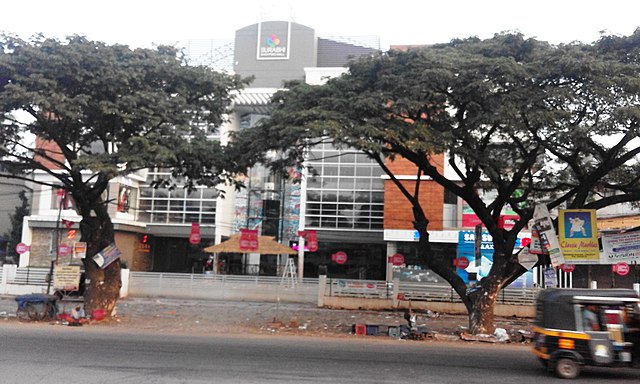
Ramanattukara
Municipality/Suburb in Kozhikode, Kerala, India From Wikipedia, the free encyclopedia
Ramanattukara is a municipality census town in Kozhikode district in the Indian state of Kerala. The town was formerly called Kadungan Chira village. Ramanattukara is located 16 km away from Kozhikode city.

Ramanattukara | |
|---|---|
Municipality/Suburb | |
 Ramanattukara town | |
| Coordinates: 11.1886744°N 75.8576775°E | |
| Country | India |
| State | Kerala |
| District | Kozhikode |
| Taluk | Kozhikode |
| Nearest city | Kozhikode |
| Population (2011) | |
• Total | 35,937 |
| Languages | |
| • Official | Malayalam, Tamil, English |
| Time zone | UTC+5:30 (IST) |
| PIN | 673633 |
| Telephone code | 0495 |
| Vehicle registration | KL 85 |
| Sex ratio | 1000:1045 ♂/♀ |
| Literacy | 95.95% |
| Lok Sabha constituency | Kozhikode |
| Vidhan Sabha constituency | Beypore |
Developing as a suburb of Kozhikode city, Ramanattukara is part of the master plan for the Kozhikode urban area.[1][2]
History
Summarize
Perspective
Ramanattukara, on the southern bank of Chaliyar river, was adjacent to the medieval kingdom of Parappanad.[3] The Parappanad royal family is a cousin dynasty of the Travancore royal family. The rulers of Parappanad were vassals to the Zamorin of Calicut.[4] The headquarters of the Parappanad royal family was the coastal town of Parappanangadi in present-day Malappuram district.[5] In 15th century CE, Parappanad Swaroopam was divided into two - Northern Parappanad (Beypore Swaroopam) and Southern Parappanad (Parappur Swaroopam).[4] Beypore, Cheruvannur, and Panniyankara, on northern bank of Chaliyar, became Northern Parappanad.[3] Kadalundi, Vallikkunnu, and Parappanangadi, on the southern bank of Chaliyar became Southern Parappanad.[3]
The ruler of the Kingdom of Tanur (Vettathunadu Swaroopam) was known to have assisted the Portuguese build a fort on the island of Chaliyam, which was a part of Southern Parappanad, and was destructed during the Battle at Chaliyam fort occurred in 1571.[4] Feroke became a part of the Kingdom of Mysore in late 18th century CE.[4] Following the Third Anglo-Mysore War and the subsequent Treaty of Seringapatam, Ramanattukara became a part of Malabar District under British Raj.[4] Ramanattukara was included in Eranad Taluk in the Malappuram Revenue Division of Malabar District with its Taluk headquarters at Manjeri.[6][3][7] Following the formation of the state of Kerala in 1956, Ramanattukara became a part of Tirurangadi Revenue block of Tirur Taluk.[5][8] On 16 June 1969, Eranad Taluk, Tirur Taluk, Tirurangadi, and Parappanangadi, were transferred to newly formed Malappuram district.[8] However, three Revenue Villages of Tirur Taluk, namely, Feroke, Ramanattukara, and Kadalundi, remained in Kozhikode district, as they were much closer to Kozhikode city centre.[8] However Kadalundi Nagaram beach (where Kadalundi River flows into Arabian Sea, a part of Vallikkunnu Grama Panchayat), Tenhipalam, the centre of University of Calicut and Karippur, the site of Calicut International Airport, became parts of Malappuram.[8] Feroke, Ramanattukara, and Kadalundi are parts of Kozhikode Taluk and Kozhikode metropolitan area.[9][10]
Demographics
| Year | Pop. | ±% |
|---|---|---|
| 1971 | 15,983 | — |
| 1981 | 21,131 | +32.2% |
| 1991 | 25,672 | +21.5% |
| 2001 | 30,436 | +18.6% |
| 2011 | 35,937 | +18.1% |
| Source: Census of India | ||
As of 2011 census, Ramanattukara had a population of 35,937. Males constituted 48.90% of the population and females 51.09%. Ramanattukara had an average literacy rate of 95.95%, higher than the national average of 74.04%: male literacy was 97.71%, and female literacy was 94.21%. In Ramanattukara, 11.46% of the population was under 6 years of age.
As of 2001[update] India census,[11] Ramanattukara had a population of 30,436. Males constituted 49% of the population and females 51%. Ramanattukara has an average literacy rate of 83%, higher than the national average of 59.5%: male literacy is 85%, and female literacy is 80%. In Ramanattukara, 12% of the population is under 6 years of age.
Election Results
Summarize
Perspective
| |||||||||||||||||||||||||||||||||||||
All 31 councils in the Ramanattukara Municipality 16 seats needed for a majority | |||||||||||||||||||||||||||||||||||||
|---|---|---|---|---|---|---|---|---|---|---|---|---|---|---|---|---|---|---|---|---|---|---|---|---|---|---|---|---|---|---|---|---|---|---|---|---|---|
| Turnout | 81.91% | ||||||||||||||||||||||||||||||||||||
| |||||||||||||||||||||||||||||||||||||
| |||||||||||||||||||||||||||||||||||||
Independents won 2 seats and have 1.31% vote share in 2020 election[12]
Political Performance in Election 2015
2010 Ramanattukara Gramapanchayat Elections
| S.No. | Political Front/Party | Number of Members |
|---|---|---|
| 1 | United Democratic Front (UDF) | 11 |
| 2 | Left Democratic Front (LDF) | 8 |
| 3 | National Democratic Alliance (NDA) | 0 |
| 4 | Others | 0 |
| Total | 19 | |
Location
Ramanattukara is situated 16 km south of Kozhikode city. Its location on the intersection of National Highway 66 had already given its economy a boost. To top it up, now the NH bypass for Kozhikode city starts from here.
Education
- Sevamandir spbhss Ramanattukara
- Ramanattukara Higher secondary school vaidyarangadi
- Government U P school Ramanattukara
- Farook arts and science college
Transportation
The nearest railhead to Ramanattukara is Feroke (5 km) and the nearest airport is Calicut International Airport (10 km).
Suburbs of Ramanattukara
- Azhinhilam
- Perumugham and Pullikkadavu
- Chelembra, Puthukode, Irumooliparamba and Karad
- Kottupadam, Kakkov, Channayilpalliyali and Akode
- Virippadam, Oorkkadavu and Korappadam
- Mundumuzhi and Valillappuzha
- Kuriyadam and Aikarappady
- Arulippuram, Vaidyarangadi and Pulikkal
- Adivaram, Kuttoolangadi and Koshavarangadi
- EranhikkalRoad, KrishiBhavan, Muttumkunnu and Kokkivalavu
- Kunnampallynagar, Madamthodi and Shanthinagar
- ManthriRoad, HomeoRoad, Poovannurpally and Ette-nalu
- Manthrammal road
- Farook College
See also
References
External links
Wikiwand - on
Seamless Wikipedia browsing. On steroids.


