Oostendam
Village in South Holland, Netherlands From Wikipedia, the free encyclopedia
Oostendam is a Dutch village. It is located in the municipality of Ridderkerk, within the province of South Holland.
Oostendam | |
|---|---|
Village | |
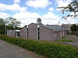
 Immanuel Chapel | |
| Coordinates: 51°51′N 4°38′E | |
| Country | Netherlands |
| Province | South Holland |
| Municipality | Ridderkerk |
| Area | |
• Total | 1.72 km2 (0.66 sq mi) |
| Elevation | 0.3 m (1.0 ft) |
| Population (2021)[1] | |
• Total | 615 |
| • Density | 360/km2 (930/sq mi) |
| Time zone | UTC+1 (CET) |
| • Summer (DST) | UTC+2 (CEST) |
| Postal code | 2989[1] |
| Dialing code | 0180 |
The village was first mentioned in 1435 as "totten cleynen Waldammen toe, die men heet op desen voorsz. tyt Dappers - dam", and means "eastern dam". The dam was founded in 1332 when Count William III had dikes built around a side-arm of the river Waal.[3] As it is currently a dead branch of the river, the locals commonly refer to it as the Waaltje, meaning Little Waal. Oostendam is located on the island of IJsselmonde, which is largely occupied by the nearby city of Rotterdam.
A part of the village was located in the municipality of Hendrik-Ido-Ambacht. It has been annexed and is now a neighbourhood with Hendrik-Ido-Ambacht. It used to have a harbour, but it was closed in 1950. In 1946, the Immanuel Chapel was built as emergency church. It was extensively modified in 1976. In 2000, the church was extended and the former day care centre was redesigned as consistory.[4]
References
Wikiwand - on
Seamless Wikipedia browsing. On steroids.


