Moculta, South Australia
Suburb of Barossa Council, South Australia From Wikipedia, the free encyclopedia
Moculta is a locality in the Australian state of South Australia located about 69 kilometres (43 mi) north-east of the state capital of Adelaide and about 12 kilometres (7.5 mi) north-east of the municipal seat of Angaston.[1][4] At the 2016 census, Moculta shared a population of 227 with part of Truro).[6]
| Moculta South Australia | |||||||||||||||
|---|---|---|---|---|---|---|---|---|---|---|---|---|---|---|---|
 Gnadenberg Church and the Hill of Grace wineyard | |||||||||||||||
 Moculta | |||||||||||||||
| Coordinates | 34°28′12″S 139°07′02″E[1] | ||||||||||||||
| Population | 228 (SAL 2021)[2] | ||||||||||||||
| Established | 1842 (sub-division) 15 May 2003[1][3] | ||||||||||||||
| Postcode(s) | 5353[4] | ||||||||||||||
| Time zone | ACST (UTC+9:30) | ||||||||||||||
| • Summer (DST) | ACST (UTC+10:30) | ||||||||||||||
| Location | |||||||||||||||
| LGA(s) | Barossa Council[1] | ||||||||||||||
| County | Light[1] | ||||||||||||||
| State electorate(s) | Schubert | ||||||||||||||
| Federal division(s) | Barker | ||||||||||||||
| |||||||||||||||
| |||||||||||||||
| Footnotes | Location[4] Adjoining localities[1] | ||||||||||||||
The earliest settlers in the area were English, Scottish and Irish migrants, among them the brothers Abraham and David Shannon. German migrants also came to the area from 1853. They built both the Gruenberg (1859) and Gnadenberg Lutheran churches. The township of Moculta itself was surveyed in 1865 and occupied soon after.[7]
The locality of Grünberg was renamed to Karalta as a consequence of the move to rename "names of enemy origin" during World War I, but has been named back to the anglicised Gruenberg since then. It is now included in Moculta and Penrice[8] Gnadenberg is also now included in Moculta.[9]
Gallery
 A dry stone wall at Mt Karinya near Moculta, South Australia.
 A dry stone wall at Mt Karinya near Moculta, South Australia.
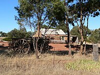 The restored cottage of the Rosenzweig's at Moculta, built circa 1859 with farm equipment in the foreground.
 The ruins of the Shannon family's farmhouse at Moculta in 2006. The steeple of the Gruenberg Lutheran church can be seen in the background.
 The Shannon family mausoleum outside of Moculta, South Australia.
 The Swan Reach to Stockwell Pipeline at Moculta, South Australia.


References
Wikiwand - on
Seamless Wikipedia browsing. On steroids.