Loading AI tools
Local government area in South Australia From Wikipedia, the free encyclopedia
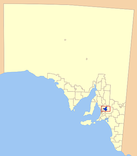
Barossa Council is a local government area in the Barossa Valley in South Australia. The council area covers 912 square kilometres, and had a population of over 23,000 in the 2016 Census.
| Barossa District Council South Australia | |||||||||||||||
|---|---|---|---|---|---|---|---|---|---|---|---|---|---|---|---|
 The location of the Barossa Council in blue | |||||||||||||||
| • Density | 27,48/km2 (7,120/sq mi) | ||||||||||||||
| Established | 1996 | ||||||||||||||
| Area | 912 km2 (352.1 sq mi) | ||||||||||||||
| Mayor | Michael "Bim" Lange [1] | ||||||||||||||
| Council seat | Nuriootpa | ||||||||||||||
| Region | Barossa Light and Lower North[2] | ||||||||||||||
| State electorate(s) | Schubert | ||||||||||||||
| Federal division(s) | |||||||||||||||
 | |||||||||||||||
| Website | Barossa District Council | ||||||||||||||
| |||||||||||||||
Barossa Council was created in July 1996, following the amalgamation of the District Council of Angaston, the District Council of Barossa and the District Council of Tanunda. The council gained a portion of the former District Council of Mount Pleasant in July 1997.[3]
Townships in the council area include
Seamless Wikipedia browsing. On steroids.
Every time you click a link to Wikipedia, Wiktionary or Wikiquote in your browser's search results, it will show the modern Wikiwand interface.
Wikiwand extension is a five stars, simple, with minimum permission required to keep your browsing private, safe and transparent.