Manirang
Indian mountain, part of the Himalayas From Wikipedia, the free encyclopedia
Indian mountain, part of the Himalayas From Wikipedia, the free encyclopedia
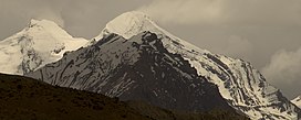
Manirang is one of the highest mountains in the Indian state Himachal Pradesh. It lies on the border between Kinnaur district and Lahaul and Spiti district. Close to the peak is the high Manirang pass, which was one of the early trade routes between Spiti and Kinnaur, before the motorable road was built. The trail over the pass starts from Mane Yogma on the Spiti side and runs to the Ropa valley in Kinnaur.[3]
| Manirang | |
|---|---|
 Manirang peak from NW direction | |
| Highest point | |
| Elevation | 6,593 m (21,631 ft)[1] |
| Prominence | 1,727 m (5,666 ft)[1] |
| Listing | Ultra |
| Coordinates | 31°57′12″N 78°22′00″E[1] |
| Geography | |
| Location | Himachal Pradesh, India |
| Parent range | Himalaya |
| Climbing | |
| First ascent | 1952, Dr. J. de V. Graaff[2] |
Seamless Wikipedia browsing. On steroids.
Every time you click a link to Wikipedia, Wiktionary or Wikiquote in your browser's search results, it will show the modern Wikiwand interface.
Wikiwand extension is a five stars, simple, with minimum permission required to keep your browsing private, safe and transparent.