List of northernmost items

From Wikipedia, the free encyclopedia

List of northernmost items

This is a list of various northernmost things on Earth.

Thumb
Longyearbyen in Svalbard (2008)
Thumb
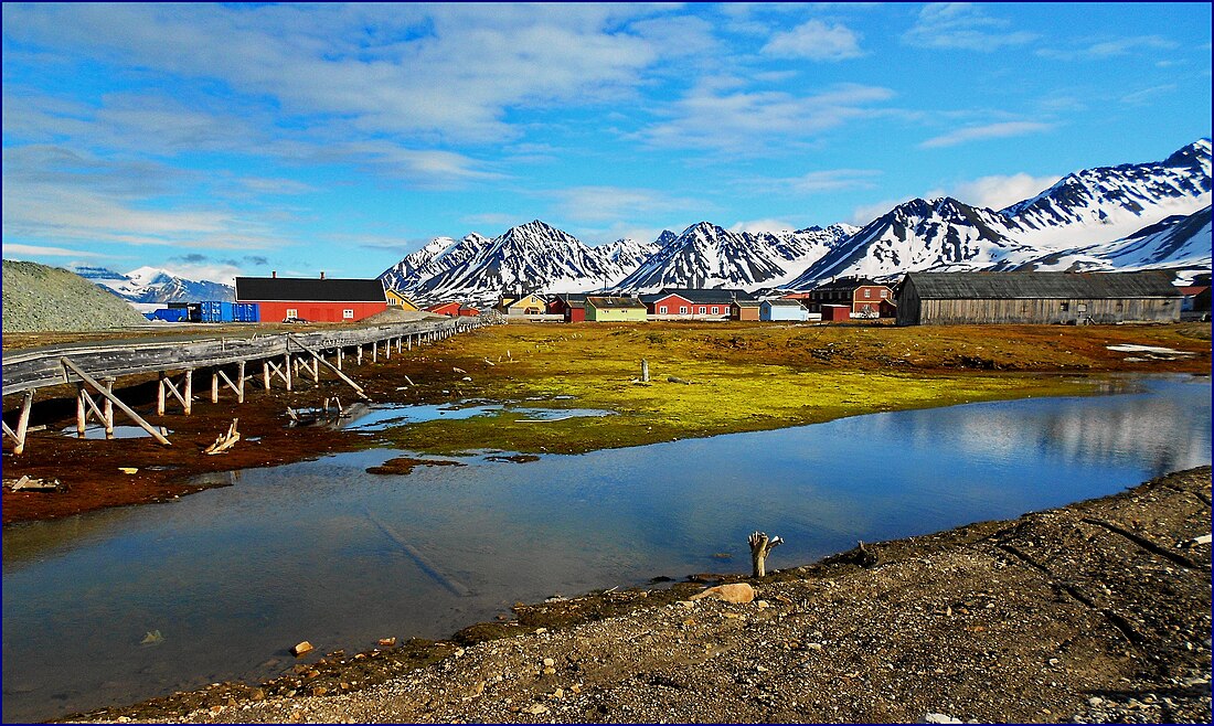
Ny-Ålesund at 79°N – location of the northernmost hotel, restaurant, and camping site.

Cities and settlements

More information Category, Place ...
Category Place Latitude/longitude
Capital (of an independent state) Reykjavík, Iceland[1] 64°08′N 21°56′W
Capital (of an autonomous territory) Nuuk, Greenland[2] 64°10′N 51°44′W
Non-permanent settlement of any size Camp Barneo[3] 88°11′N 30°45′W (may vary as it changes every summer)
Permanent settlement of any size Alert, Nunavut (CFS Alert), Canada[4] 82°28′N 62°30′W
Non-active public settlement (ghost town) Wandel Dal Settlements, Greenland[5] 82°15′N 35°15′W
Active public settlement Ny-Ålesund, Svalbard, Norway 78°55′30″N 11°55′20″E
Village inhabited by native people Siorapaluk, Greenland[6] 77°47′08″N 70°38′00″W
Medieval town Vágar, Austvågøy, Lofoten, Norway[7] 68°20′N 14°40′E
City > 1,000 people Longyearbyen, Svalbard, Norway[8] 78°13′N 15°33′E
City > 2.500 people Khatanga, Russia[9]71°59′N 102°28′E
City > 4,000 people Tiksi, Russia 71°38′N 128°52′E
City > 4,500 people Utqiagvik, Alaska, United States[10] 71°17′N 156°47′W
City > 10,000 people Hammerfest, Norway[11] 70°39′45″N 23°41′00″E
City > 20,000 people Alta, Norway[11] 69°58′36″N 23°17′45″E
City > 50,000 people Tromsø, Norway[11] 69°40′33″N 18°55′10″E
City > 100,000 people Norilsk, Russia[12][13] 69°21′N 88°12′E
City > 250,000 people Murmansk, Russia68°58′N 33°05′E
City > 300,000 people Arkhangelsk, Russia64°32′N 40°32′E
City > 350,000 people Yakutsk, Russia62°02′N 129°44′E
City > 375,000 people Surgut, Russia61°16′N 73°24′E
City > 500,000 people Helsinki, Finland60°10′15″N 24°56′15″E
City > 1,000,000 people
City > 5,000,000 people
Saint Petersburg, Russia[14]59°57′N 30°18′E
City > 10,000,000 people
Metropolitan area > 20,000,000 people
Moscow, Russia[14][15]55°45′N 37°37′E
Close

Geography

More information Category, Place ...
Category Place Latitude/longitude
Lake Kaffeklubben Sø, Greenland[16] 83°35′N 32°35′W
Pond Lake North Pole, North Pole (on ice)[17] 85°N 5°W[18]
Permanent island Kaffeklubben Island, Greenland[19] 83°40′N 29°50′W
Non-permanent island Qeqertaq Avannarleq, Greenland
Lake island Gatter Island, Lake Hazen, Canada 81°55′4.8″N 69°5′34.8″W
Archipelago Arctic Archipelago, Canada (northernmost point, Cape Columbia, Ellesmere Island) 83°06′41″N 069°57′30″W
Sea Lincoln Sea, Greenland and Canada 83°37′N 32°31′W (northernmost point)
Bay Constable Bay, Greenland[20] 83°36′N 32°33′W
Mountain range Roosevelt Range, Greenland[21] 83°16′N 35°0′W
National park Northeast Greenland National Park, Greenland 83°40′N 29°50′W (northernmost point)
Continental mainland Cape Chelyuskin, Taymyr Peninsula, Krasnoyarsk Krai, Russia 77°44′N 104°15′E
Active volcano Beerenberg, Jan Mayen, Norway[22] 71°4′36″N 8°9′52″W
Coral reef Korallen,[23] Finnmark, Norway 70°40′N 22°00′E
Location with all monthly
average temperatures above freezing
Bø Municipality, Nordland, Norway[24] 68°37′N 14°27′E
Crater lake Lake Lappajärvi, Lappajärvi,[25] Finland 63°7′N 23°40′E
Beach of southern type[A] Farstadsanden, Hustadvika Municipality,[26][better source needed] Norway 62°54′28″N 7°6′30″E
Active sand dunes Great Kobuk Sand Dunes, Alaska, United States[27] 67°03′42″N 158°56′44″W
Coral atoll Kure Atoll, Hawaii, United States[28] 28°25′16″N 178°19′55″W
Tropical sea Red Sea[29] 22°N 38°E
Close

Nature

Summarize
Perspective

Wild animals

Plants

These lists only contain naturally occurring plants and trees, excluding individuals planted by humans.

General

Shrubs

More information Plant, Place ...
Plant Place Latitude/longitude
Willow (Arctic willow Salix arctica) Reaches the northern limits of land in Greenland[48]
Close

Trees

More information Plant, Place ...
Plant Place Latitude/longitude
Larch (Dahurian larch Larix gmelinii) About 150 kilometres (93 mi) westward of Khatanga River outfall, Taymyr Peninsula, Siberia, Russia.[49]
This location is that of the northernmost tree of any kind (this is a creeping form of Dahurian larch)
73°04′32″N 102°00′00″E
Close

Education

Summarize
Perspective
More information Category, Place ...
Category Place Latitude/longitude
Kindergarten Kullungen barnehage and Polarflokken barnehage,[50] Longyearbyen, Svalbard, Norway 78.22°N 15.65°E / 78.22; 15.65 (coordinates of Longyearbyen)
Primary/secondary school Longyearbyen School,[51] Longyearbyen, Svalbard, Norway 78.20°N 15.61°E / 78.20; 15.61
Higher education institute University Centre in Svalbard,[52] Longyearbyen, Svalbard, Norway 78°13′N 15°36′E
Agricultural school Tana videregående skole,[53] Tana Municipality, Norway 70.438307°N 28.248596°E / 70.438307; 28.248596
Montessori school Tana Montessoriskole,[54] Tana Municipality, Norway 70.235095°N 28.193981°E / 70.235095; 28.193981
Folk high school Svalbard Folkehøgskole,[55] Longyearbyen, Svalbard, Norway 78.22400°N 15.64880°E / 78.22400; 15.64880
International Baccalaureate Kirkenes,[56] Norway 69.688332°N 30.000539°E / 69.688332; 30.000539
Music conservatory Conservatory of Tromsø,[57] Tromsø, Norway 69.636076°N 18.914459°E / 69.636076; 18.914459
Art school Karasjok,[58] Norway 69.469836°N 25.511189°E / 69.469836; 25.511189
University University of Tromsø,[59][60] Tromsø, Norway 69°40′N 18°56′E
Gardening school Rå videregående skole,[61] Borkenes, Norway 68.775058°N 16.176908°E / 68.775058; 16.176908
Catholic school St. Eystein skole,[62] Bodø, Norway (Primary school)

Monroe Catholic High School,[63] Fairbanks, Alaska, United States (High school)

67.275757°N 14.366561°E / 67.275757; 14.366561

64.851296°N 147.715669°W / 64.851296; -147.715669

Architecture school University of Oulu, Oulu, Finland 65.059291°N 25.466240°E / 65.059291; 25.466240
School for the deaf Kristinaskolan School for the Deaf,[64] Härnösand, Sweden 62.627719°N 17.949657°E / 62.627719; 17.949657
Close

Science and technology

More information Category, Place ...
Category Place Latitude/longitude
Scientific laboratory Camp Barneo,[65] Russian arctic laboratory Floating relatively close to the North Pole
Observatory Arctic Geodetic Earth Observatory, Ny-Ålesund, Svalbard, Norway[66] 78°55′N 11°56′E
Sewage farm Kings Bay, Ny-Ålesund, Svalbard, Norway[67] 78°55′N 11°56′E
LTE cell tower Longyearbyen, Svalbard, Norway[68] 78.22°N 15.65°E / 78.22; 15.65 (Longyearbyen, Norway)
Oil platform Goliat, Arctic Ocean[69] 71°39′N 25°53′E
Wind farm Tiksi,[70] Yakutia, Russia 71.65°N 128.866667°E / 71.65; 128.866667
LNG plant Melkøya,[71] Hammerfest, Norway 70.690°N 23.599°E / 70.690; 23.599
High voltage power line Balsfjord-Hammerfest,[72][73] Norway 70°39′45″N 23°41′00″E
Planetarium Northern Light Planetarium,[74] Tromsø, Troms, Norway 69.679113°N 18.971710°E / 69.679113; 18.971710
Web conferencing Tag-IT,[75] Tromsø, Norway 69°40′58″N 18°56′34″E
Astronomical Observatory Skibotn Observatory,[76] Storfjord Municipality, Norway 69.391667°N 20.269722°E / 69.391667; 20.269722
Smeltery Finnfjord AS,[77] Finnsnes, Norway 69.221222°N 18.086540°E / 69.221222; 18.086540
Permanent launch facility for sounding rockets & scientific balloons Andøy Municipality,[78] Norway 69°5′40″N 15°45′52″E
Radioactive waste plant Murmansk,[79] Russia 68°58′N 33°05′E
Solar power station Inari, Finland[80] 68°54′N 27°01′E
Car testing center White Hell,[81] Saariselkä, Inari, Finland 68°15′N 28°10′E
Nuclear Power Plant (mobile) Akademik Lomonosov, Pevek harbor, Chukotka Autonomous Okrug, Russia[82] 69°42′35″N 170°18′36″E
Spaceport Esrange Space Center,[83] Jukkasjärvi, Kiruna, Sweden 67.893157°N 21.064685°E / 67.893157; 21.064685
Laser cutting machine LKAB Mekaniska,[84] Kiruna, Sweden 67°51′N 20°13′E
Biogas plant Ammattiopisto Lappia,[85] Tervola, Finland 66.158504°N 24.991134°E / 66.158504; 24.991134
Crusher Kajaanin Romu,[86] Kajaani, Finland 64.217726°N 27.685214°E / 64.217726; 27.685214
Psycholinguistics and neurolinguistics laboratory University Hospital of Trondheim,[87] Trondheim, Norway 63.421038°N 10.388050°E / 63.421038; 10.388050
Close

Historical sites and archaeological findings
Thumb
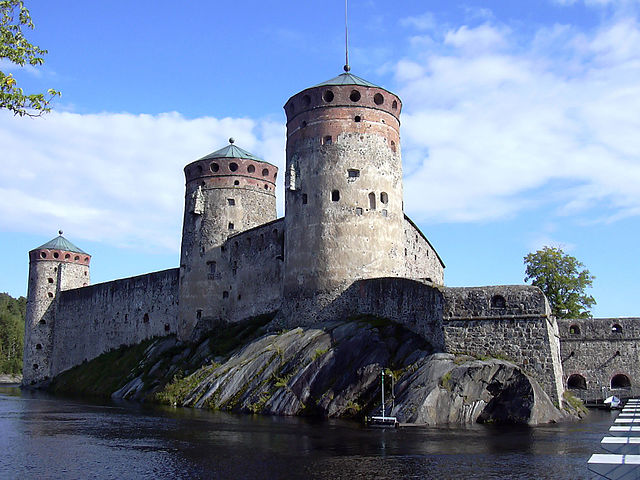
Olavinlinna, Savonlinna, Finland

Recreation

General

Culture and music

Thumb
Ny-Ålesund Town and Mine Museum, Svalbard, Norway
Thumb
Hålogaland Teater, Tromsø, Norway
Thumb
Norrlandsoperan, Umeå, Sweden
More information Category, Place ...
Category Place Latitude/longitude
Museum Ny-Ålesund Town and Mine Museum,[111] Ny-Ålesund, Svalbard, Norway 78°55′30″N 11°55′20″E
Piano Pyramiden, Svalbard, Norway[112] 78°41′N 16°24′E
Chamber music festival Arctic Chamber Music Festival,[113] Longyearbyen, Svalbard, Norway 78.22°N 15.62°E / 78.22; 15.62
Children's choir Polargospel,[114] Longyearbyen, Svalbard, Norway 78.22°N 15.62°E / 78.22; 15.62
Electric Organ Svalbard Church,[115] Longyearbyen, Svalbard, Norway 78.22°N 15.62°E / 78.22; 15.62
Literature festival Longyearbyen Literature Festival,[116] Longyearbyen, Svalbard, Norway 78.22°N 15.62°E / 78.22; 15.62
Men's chorus Store Norske Mandskor,[117][118] Longyearbyen, Svalbard, Norway 78.22°N 15.62°E / 78.22; 15.62
Mixed choir Longyearbyen blandakor,[117] Longyearbyen, Svalbard, Norway 78.22°N 15.62°E / 78.22; 15.62
Oktoberfest Oktoberfest 78° Nord,[119] Longyearbyen, Svalbard, Norway 78.22°N 15.65°E / 78.22; 15.65 (Oktoberfest)
Cinema Kulturhuset,[120] Longyearbyen, Svalbard, Norway 78.219502°N 15.643380°E / 78.219502; 15.643380
Art gallery The Gallery and Longyearbyen Arts & Crafts Centre,[121] Longyearbyen, Svalbard, Norway 78°20′N 15°59′E
Blues festival Dark Season Blues,[122] Longyearbyen, Svalbard, Norway 78°15′N 15°31′E
Rock festival Spitsbergen Rock festival,[123] Longyearbyen, Svalbard, Norway 78°15′N 15°31′E
Jazz festival Polarjazz,[124] Longyearbyen, Svalbard, Norway 78°15′N 15°31′E
Photo club Longyearbyen fotoklubb,[125] Longyearbyen, Svalbard, Norway 78°15′N 15°31′E
Pipe organ Qaanaaq church,[126] Qaanaaq, Greenland, Denmark 77°28′00″N 69°13′50″W
Open-air museum Upernavik,[127] Greenland, Denmark 72°47′13″N 56°08′50″W
Beer Festival Skarsvåg,[128] Norway 71°06′47″N 25°49′37″E
Graffiti Gjesvær,[129] Norway 71°05′53″N 25°22′34″E
Christmas museum Mehamn,[130] Gamvik Municipality, Norway 71°02′08″N 27°50′57″E
Film festival Nordkapp filmfestival,[131] Honningsvåg, Norway 70°58′43″N 25°58′36″E
Film studio Orto Polare AS, Kjøllefjord,[132] Norway 70°56′44″N 27°20′47″E
Dance theatre Stellaris DansTeater, Hammerfest,[133] Norway 70.674195°N 23.656032°E / 70.674195; 23.656032
String orchestra Oppstryk Finnmark, Hammerfest,[134] Norway 70.664141°N 23.689717°E / 70.664141; 23.689717
Dance festival DanseFestival Barents,[135] Hammerfest, Norway 70°39′45″N 23°41′00″E
Outdoor music festival Midnattsrocken,[136] Lakselv, Norway 70°03′04″N 24°58′18″E
Art festival Barents Spektakel, Sør-Varanger Municipality,[137] Norway 69.726536°N 30.040090°E / 69.726536; 30.040090
Professional theatre Samovarteateret, Kirkenes,[138] Norway 69.723740°N 30.057177°E / 69.723740; 30.057177
Tango club Tango Polar, Tromsø,[139] Norway 69.652299°N 18.962599°E / 69.652299; 18.962599
Regional theatre Hålogaland Teater, Tromsø,[140] Norway 69.642188°N 18.944700°E / 69.642188; 18.944700
Heavy Metal Music Festival Iskald,[141] Alta, Norway 69°58′07″N 23°16′17″E
Soul and Blues Festival Alta Soul & Blues Festival,[142] Alta, Norway 69°56′N 23°18′E
Animation studio Fabelfjord, Tromsø,[143] Norway 69°38′50″N 18°57′20″E
Lindy Hop dance group Tromsø Lindy Hop, Tromsø,[144] Norway 69°38′50″N 18°57′20″E
Stand-up comedy club Stand Up Nord, Tromsø,[145] Norway 69°38′50″N 18°57′20″E
Stunt company Arctic Action AS, Tromsø,[146] Norway 69°38′50″N 18°57′20″E
Symphony orchestra Norwegian Arctic Philharmonic Orchestra, based in both Tromsø (more northerly) and Bodø,[147] Norway 69°38′50″N 18°57′20″E
NAF Blood Bowl Tournament da Keffo Kup,[148] Setermoen, Bardu Municipality, Norway 68°54′16″N 18°24′01″E
Country music Festival Hålogaland Country Festival, Harstad,[149] Norway 68°48′00″N 16°32′45″E
Military band Military band of Northern Norway, Harstad,[150] Norway 68°48′00″N 16°32′45″E
Doll museum Lofoten Toy Museum, Sakrisøy, Reine,[151] Norway 67.941335°N 13.111239°E / 67.941335; 13.111239
Folk dance theatre Rimpparemmi, Rovaniemi,[152] Finland 66.499621°N 25.713644°E / 66.499621; 25.713644
Design week Arctic Design, Rovaniemi,[153] Finland 66°30′N 25°44′E
Light festival Polar Night Light Festival, Rukatunturi, Kuusamo,[154] Finland 66°11′46″N 29°06′45″E
Comics Festival Kemi International Comics Festival, Kemi,[155] Finland 65°44′N 24°33′E
Barbershop choir Lule Barbershop Singers, Luleå,[156] Sweden 65.583977°N 22.151046°E / 65.583977; 22.151046
Shakespeare theatre Fairbanks Shakespeare Theatre, Fairbanks,[157] Alaska, United States 64.843142°N 147.719628°W / 64.843142; -147.719628
Crime fiction festival Iceland Noir, Reykjavík,[158] Iceland 64°08′00″N 21°56′00″W
Samba dance group Samba el Gambo, Kokkola,[159] Finland 63.837039°N 23.103583°E / 63.837039; 23.103583
Opera house Norrlandsoperan, Umeå,[160] Sweden 63.827880°N 20.268853°E / 63.827880; 20.268853
Ukulele festival Tropical Winter Ukulele Fest, Leppävirta,[161] Finland 62°29′30″N 27°47′15″E
4DX cinema Cinema Park, Surgut City Mall, Surgut,[162] Russia 61°15′N 73°26′E
Sea shanty festival Baltic Shanty Festival, Mariehamn, Åland,[163] Finland 60°5′55″N 19°56′40″E
Amphitheatre Saint Petersburg, Russia[164] 59°56′N 30°20′E
Close

Sport

Thumb
Alfheim Stadion, Tromsø, Norway
Thumb
Fiann Paul, Alex Gregory, and Carlo Facchino made the northernmost latitude record by rowing.[165]
More information Category, Place ...
Category Place Latitude/longitude
Ocean Rowing expedition Polar Row led by Fiann Paul[166] 79.56°N 10.23°E / 79.56; 10.23
Cycling sport Arctic Race of Norway, Longyearbyen, Norway[167] 78°13′N 15°37′E
Fell running Platåfjellet, Svalbard, Norway[168] 78°13′N 15°37′E
Judo club Longyearbyen, Norway[169] 78°13′N 15°37′E
Marathon running race Spitsbergen Marathon, Longyearbyen, Norway[170] 78°13′N 15°37′E
Marathon ski race Svalbard Skimaraton, Longyearbyen, Norway 78°13′N 15°37′E
Swimming pool, at least 20 metres (66 ft) Longyearbyen, Norway 78°12′38″N 15°36′49″E
Gym Longyearbyen, Norway[171] 78°12′38″N 15°36′49″E
Football school Qaanaaq,[172] Greenland, Denmark 77°27′48″N 69°10′37″W
Taekwondo club Qaanaaq,[173] Greenland, Denmark 77°28′00″N 69°13′50″W
American football field Utqiaġvik, Alaska, United States[174] 71°19′56″N 156°39′45″W
High school American football team Utqiaġvik, Alaska, United States[175][176][177] 71°17′N 156°45′W
Football (soccer) field Qaanaaq, Greenland[178] 77°27′48″N 69°10′37″W
Artificial turf Honningsvåg gym,[179] Honningsvåg, Norway 70.976459°N 25.979430°E / 70.976459; 25.979430
Beach volleyball field Qaanaaq, Greenland[180] 77°27′56″N 69°14′30″W
Diving school Kongsfjord International Scuba School,[181] Kongsfjord, Berlevåg Municipality, Norway 70.719637°N 29.321841°E / 70.719637; 29.321841
Nine-hole golf course Ulukhaktok, Northwest Territories, Canada[182] 70°44′N 117°45′W
Skatepark Alta, Norway[183] 70°2′5″N 23°32′9″E
Sled dog marathon Finnmarksløpet, Alta, Norway[184] 70°2′5″N 23°32′9″E
Climbing park Sarves, Alta, Norway[185] 69.972232°N 23.368176°E / 69.972232; 23.368176
Outdoor swimming pool Skittenelv Camping, Krokelvdalen, Tromsø Municipality[186] Norway 69.777468°N 19.382298°E / 69.777468; 19.382298
Ice hockey club Kirkenes Puckers, Kirkenes,[187] Norway 69°43′37″N 30°02′44″E
Squash centre Tromsø Golf and Squash park, Tromsø,[188] Norway 69.695476°N 19.013426°E / 69.695476; 19.013426
CrossFit center CrossFit Tromsø, Tromsø,[189] Norway 69.660435°N 18.964001°E / 69.660435; 18.964001
Floorball elite league Tromsø Floorball Club, Tromsø,[190] Norway 69.658155°N 18.964791°E / 69.658155; 18.964791
Kung fu club Hung Kuen, Tromsø,[191] Norway 69.652577°N 18.962951°E / 69.652577; 18.962951
Football arena Alfheim Stadium, Tromsø,[185] Norway 69.648916°N 18.934309°E / 69.648916; 18.934309
Football elite league Tromsø Idrettslag, Tromsø,[192] Norway 69.648884°N 18.935547°E / 69.648884; 18.935547
Ice skating rink Tromsdalen kunstisbane, Tromsdalen, Tromsø,[193] Norway 69.645814°N 19.019548°E / 69.645814; 19.019548
Aikido club Aikido Reimeikan, Tromsø, Norway[194] 69°40′N 19°04′E
Curling club Boet curlingklubb, Tromsø, Norway[195] 69°40′N 19°04′E
Ski resort Tromsø Municipality, Norway[196]Also self claimed 69°40′N 19°04′E
18 hole golf course Tromsø Golfpark at Breivikeidet near Tromsø, Norway[74] 69°39′30″N 19°37′00″E
Parachute association Tromsø Parachute Association, Tromsø, Norway[197] 69°37′07″N 18°57′12″E
Ice arena Taymyr, Dudinka, Russia[198] 69°24′N 86°11′E (coordinates of Dudinka)
Sailing regatta Severomorsk, Russia[199] 69°04′N 33°25′E (coordinates of Severomorsk)
Drag racing rail Arctic Raceway AS, Elvenes, Salangen Municipality, Norway[200] 68.870959°N 17.983686°E / 68.870959; 17.983686
Harness racing track Harstad Travpark, Harstad, Norway[201] 68.789046°N 16.459734°E / 68.789046; 16.459734
Disc golf course Ivalon Frisbeegolfrata, Ivalo, Inari, Finland[202] 68.684169°N 27.502706°E / 68.684169; 27.502706
Links-styled golf course Lofoten Links, Gimsøysand,[203] Lofoten, Norway 68.340377°N 14.128495°E / 68.340377; 14.128495
Surfing competition Lofoten Masters, Bøstad,[204] Norway 68.265272°N 13.591308°E / 68.265272; 13.591308
Downhill mountain biking track Levi, Ylläs, Kolari,[205] Finland 67.806001°N 24.798537°E / 67.806001; 24.798537
Steeplechase race Arctic Challenge, Levi, Ylläs, Kolari,[206] Finland 67.805°N 24.802°E / 67.805; 24.802
Hot yoga studio Kuru Yoga, Levi Hotel Spa, Levi, Ylläs, Kolari,[207] Finland 67.803832°N 24.800942°E / 67.803832; 24.800942
Triathlon school Levi, Ylläs, Kolari,[208] Finland 67.805°N 24.802°E / 67.805; 24.802
Triathlon Lofoten Triathlon, Svolvær, Norway[209] 68°13′56″N 14°33′55″E
Yoga Festival Arctic Yoga Conference, Bodø, Norway[210] 67°16′N 14°24′E
Race track Arctic Circle Raceway, Mo i Rana, Norway[211] 66.423574°N 14.444912°E / 66.423574; 14.444912
Footgolf course Helgeland Golfklubb, Helgeland, Norway[212] 65.926646°N 13.310752°E / 65.926646; 13.310752
27 hole golf course Luleå Golfklubb, Luleå, Sweden[213] 65.683325°N 22.090118°E / 65.683325; 22.090118
Ice hockey elite league Luleå Hockey, Luleå, Sweden[214] 65.597812°N 22.148316°E / 65.597812; 22.148316
Padel field Padel 365, Luleå, Sweden[215] 65.597177°N 22.143614°E / 65.597177; 22.143614
Kendo society Kendo Society of Tornio, Tornio, Finland[216] 65°51′N 24°09′E
36 hole golf course Piteå Golfklubb, Piteå, Sweden[217] 65.317513°N 21.528037°E / 65.317513; 21.528037
Cable wakeboard line Oulu Wakepark Oy, Oulu, Finland[218] 65.011311°N 25.476684°E / 65.011311; 25.476684
Disc golf competition Naamivaara Open, Oulu, Finland[219] 65°01′N 025°28′E
Gaelic Athletic Association club Oulu Irish Elks, Oulu, Finland[220] 65°01′N 25°28′E
Lido Otanmäki Lido, Otanmäki, Kajaani, Finland[221] 64.107894°N 27.102595°E / 64.107894; 27.102595
Cricket field Iceland Cricket Ground, Víðistaðatún, Hafnarfjörður, Iceland[222] 64.074897°N 21.9636155°W / 64.074897; -21.9636155
Indoor surfing area Radisson Blu Resort Trysil, Trysil Municipality, Norway[223] 61.307787°N 12.244302°E / 61.307787; 12.244302
Cricket club Oulu Cricket Club Oulu, Finland 65°01′N 025°28′E
Ski jumping hill Grønnåsen hoppbakke, Tromsø, Norway 69˚69N 018˚96E
Ski jumping hill with plastic matting for year round jumping Grønnåsen hoppbakke k6 and K15, Tromsø, Norway 69˚69N 018˚96E
Close

Religious structures

Thumb
Church of St. Nicholas the Miracle Worker, Franz Josef Land, Russia
Thumb
Svalbard Church, Svalbard
Thumb
Nord Kamal Mosque, Norilsk, Russia
More information Category, Place ...
Category Place Latitude/longitude
Church (Eastern Orthodox Church) (military church) Church of St. Nicholas the Miracle Worker,[224] Alexandra Land, Franz Josef Land, Arkhangelsk Oblast, Russia 80°48′0″N 047°44′0″E
Lutheran confirmation Longyearbyen,[117] Svalbard, Norway 78.22°N 15.65°E / 78.22; 15.65
Church (Lutheran church) (civilian church) Svalbard church,[225] Longyearbyen, Svalbard, Norway 78.219831°N 15.618314°E / 78.219831; 15.618314 (Svalbard kirke)
Haziratu'l-Quds (a.k.a. Baháʼí Faith Centre) Haziratu'l-Quds established prior to 1957[226] in Qaanaaq, Greenland, Denmark 77.467178°N 69.230046°W / 77.467178; -69.230046 (Baháʼí Centre in Qaanaaq) (coordinates of Qaanaaq)
Anglican church St Peter's Church,[227] Grise Fiord, Nunavut, Canada 76.2503°N 82.5338°W / 76.2503; -82.5338 (St Peter's Church) (coordinates of Grise Fiord)
Eastern Orthodox Church (civilian) Church of Saint Nicholas,[228] Dikson, Russia 73°30′N 80°31′E
Catholic church Church of the Sacred Heart of Jesus,[229] Pond Inlet, Nunavut, Canada 72.695411°N 77.978643°W / 72.695411; -77.978643 (Church of the Sacred Heart of Jesus)
Latter-day Saint church Boxer Chapel,[230] Utqiaġvik, Alaska, United States 71.301133°N 156.761766°W / 71.301133; -156.761766 (Church Of Jesus Christ Of Lds)
Seventh-day Adventist Church Barrow SDA Church,[231] Utqiaġvik, Alaska, United States 71.300871°N 156.734236°W / 71.300871; -156.734236 (Barrow SDA Church)
Presbyterian church Utqiagvik Presbyterian Church in Utqiaġvik,[232] Alaska, United States 71.292347°N 156.783979°W / 71.292347; -156.783979 (Utqiagvik Presbyterian Church)
Assemblies of God church Inupiat Assembly of God, Utqiaġvik,[233] Alaska, United States 71.290839°N 156.788271°W / 71.290839; -156.788271 (Inupiat Assembly of God)
Baptist church Calvary Bible Baptist Church,[234] Utqiaġvik, Alaska, United States 71.288602°N 156.783176°W / 71.288602; -156.783176 (Calvary Bible Baptist Church)
Pilgrimage church Skarsvåg Church,[235] Skarsvåg, Norway 71.109886°N 25.817709°E / 71.109886; 25.817709 (Skarsvåg Church)
Methodist church Metodistkirken in Hammerfest,[236] Norway 70.662038°N 23.681323°W / 70.662038; -23.681323 (Metodistkirken in Hammerfest,<)
Kingdom Hall of Jehovah's Witnesses Rikets sal, Rypklubbveien, Hammerfest, Norway[237] 70.648750°N 23.662830°E / 70.648750; 23.662830 (Hammerfest menighet)
Clergy house Måsøy Municipality, Norway[238] 70°59′48″N 24°39′40″E (coordinates of Måsøy)
Ecumenic chapel St. Johannes kapell, Nordkapp Municipality, Norway[239] 70°58′41″N 25°58′29″E (coordinates of Nordkapp)
Salvation Army Guesthouse Frelsesarmeen Vardø korps, Vardø, Norway[240] 70.370278°N 31.110824°E / 70.370278; 31.110824
Deaf ministry Tromsø,[241] Norway 69.680827°N 19.062824°E / 69.680827; 19.062824 (Døves menighet)
Cathedral Vår Frue Church,[138] Tromsø, Norway 69.651600°N 18.956762°E / 69.651600; 18.956762 (Vår Frue Kirke)
Bible school Fjellheim Bible School,[242] Tromsø, Norway 69.638686°N 18.930836°E / 69.638686; 18.930836 (Fjellheim bibelskole)
Mosque Alnor Senter, Tromsø, Norway[243][244]
69°39′15.01″N 18°57′36.25″E
Mosque Custom Built Nurd Kamal Mosque, Norilsk, Russia[245] 69°20′27.19″N 88°12′3.21″E
New Apostolic Church Murmansk,[246] Russia 68.955445°N 33.067698°E / 68.955445; 33.067698 (New Apostolic Church of Murmansk)
Medieval church Trondenes Church,[247] Norway 68.8220°N 16.5622°E / 68.8220; 16.5622 (Trondenes Church)
Jewish community Murmansk,[248] Russia 68°58′N 33°05′E
Eckankar temple Inuvik,[249] Northwest Territories, Canada 68.35°N 133.42°W / 68.35; -133.42 (coordinates of Inuvik)
Buddhist temple and monastery Fredens hus, Boden, Sweden[250] 65°50′N 21°43′E
Quaker meeting house Hidden Hill Friends Center, Fairbanks,[251] Alaska, United States 64.862089°N 147.917513°W / 64.862089; -147.917513
Synagogue (Reform) Fairbanks,[252] Alaska, United States 64.860015°N 147.762711°W / 64.860015; -147.762711 (Congregation Or HaTzafon)
Unitarian Universalist church Unitarian Universalist Church, Fairbanks,[253] Alaska, United States 64.835057°N 147.847183°W / 64.835057; -147.847183 (Unitarian Universalist church of Fairbanks)
Wicca coven, group or organisation Fairbanks & North Pole Pagan Wives, Fairbanks,[254] Alaska, United States 64°50′37″N 147°43′23″W (coordinates of Fairbanks)
Christian Community Church Kristensamfunnet Trøndelag,[255] Trøndelag, Norway 63.432224°N 10.392182°E / 63.432224; 10.392182 (Kristensamfunnet Trøndelag)
Gothic cathedral Nidaros Cathedral,[256] Trondheim, Norway 63.426905°N 10.396948°E / 63.426905; 10.396948 (Nidaros Cathedral)
Orthodox Jewish synagogue Trondheim,[257] Norway 63.426381°N 10.392931°E / 63.426381; 10.392931 (Synagogen i Trondheim)
Pilgrimage route St. Olavsleden, Selånger-Trondheim[258] 63°25′37″N 10°23′35″E
Armenian church Saint Karapet,[259] Yakutsk, Sakha, Russia 62.03°N 129.73°E / 62.03; 129.73 (Saint Karapet)
Buddhist datsan Lotus,[260] Yakutsk, Sakha, Russia 62.03°N 129.73°E / 62.03; 129.73 (Lotus) (coordinates of Yakutsk)
Buddhist stupa Siikainen stupa, Siikainen, Finland[261] 61.915016°N 21.925590°E / 61.915016; 21.925590 (Siikainen stupa)
Hindu temple Sri Ganesha Hindu temple,[262] Anchorage, Alaska, United States 61.179746°N 149.961920°W / 61.179746; -149.961920 (Sri Ganesha Hindu temple)
Taoist center Taoism Center for Wellness,[263] Anchorage, Alaska, United States 61.173643°N 149.887990°W / 61.173643; -149.887990
Mennonite church Prince of Peace Mennonite Church,[264] Anchorage, Alaska, United States 61.121434°N 149.748460°W / 61.121434; -149.748460
Sikh Gurudwara The Sikh Society of Alaska,[265] Anchorage, Alaska, United States 61.114961°N 149.743202°W / 61.114961; -149.743202 (The Sikh Society of Alaska)
Mormon temple Anchorage Alaska Temple,[266] Anchorage, Alaska, United States 61.101651°N 149.840289°W / 61.101651; -149.840289
Hare Krishna temple Malmi Manor,[267] Malmi, Helsinki, Finland 60.2510°N 25.0106°E / 60.2510; 25.0106 (Helsinki ISKCON)
Metropolitan Community Church Elävä vesi MCC, Helsinki, Finland[268] 60°10′15″N 24°56′15″E (coordinates of Helsinki)
Liberal Catholic Church Church of Saint Michel and all Angels,[269] Stockholm, Sweden 59.322198°N 17.994805°E / 59.322198; 17.994805
Coptic Church St. Mary & St. Paul Coptic Orthodox Church,[270] Stockholm, Sweden 59.303355°N 18.007904°E / 59.303355; 18.007904
Scientology church Scientologi-kyrkan,[271] Stockholm, Sweden 59.264422°N 17.903386°E / 59.264422; 17.903386 (Scientologi-kyrkan)
Hutterian church Hutterian Brethren Church,[272] Eaglesham, Alberta, Canada 55.726205°N 117.961783°W / 55.726205; -117.961783 (Hutterian Brethren Church)
Ancient Roman temple Maryport,[273] England, United Kingdom 54.7128°N 3.4926°W / 54.7128; -3.4926 (coordinates of Maryport)
Christian Science church First Church of Christ, Scientist,[274] Anchorage, Alaska, United States 61.2078°N 149.9038°W / 61.2078; -149.9038 (Christian Science Church)
Jain temple Jain Samaj,[275] Manchester, United Kingdom 53.450945°N 2.192403°W / 53.450945; -2.192403 (Jain Samaj)
Shinto shrine Japanese Dutch Shinzen Foundation,[276] Amsterdam, Netherlands 52.373217°N 4.924987°E / 52.373217; 4.924987 (Japanese Dutch Shinzen Foundation)
Amish community Rexford community[277] in Rexford, Montana, United States 48.53°N 115.10°W / 48.53; -115.10 (coordinates of Rexford, Montana)
Zoroastrian fire temple (defunct) Archaeological remains of a fire temple[278] in Tbilisi, Georgia 41.43°N 44.47°E / 41.43; 44.47 (fire temple) (coordinates of Tbilisi)
Zoroastrian fire temple (active) Fire Temple of Yazd in Yazd, Iran 31.905556°N 54.339167°E / 31.905556; 54.339167
Close

Monasteries, religious orders and institutions

Thumb
Pechenga Monastery, Murmanskaya, Russia

Transportation

Summarize
Perspective
Thumb
Kvalsund Bridge, Kvalsund, Norway
Thumb
Mellunmäki metro station, Helsinki, Finland
More information Category, Place ...
Category Place Latitude/longitude
Unscheduled airport Alert Airport, Nunavut, Canada[4][289] 82°31′04″N 062°16′50″W
Locomotive Ny-Ålesund, Svalbard, Norway[290] 78°55′N 11°56′E
Asphalt concrete Longyearbyen,[291] Svalbard, Norway 78.22°N 15.65°E / 78.22; 15.65
Bicycle-sharing system Longyearbyen[292] Svalbard, Norway 78.22°N 15.65°E / 78.22; 15.65
Bus station Longyearbyen,[293] Svalbard, Norway 78.22°N 15.65°E / 78.22; 15.65
Car rental Arctic Autorent AS,[294] Svalbard, Norway 78.22°N 15.65°E / 78.22; 15.65
Cargo route MS Norbjørn,[295] TromsøLongyearbyen, Norway 78.22°N 15.65°E / 78.22; 15.65
Harbor Longyearbyen Harbor,[296] Longyearbyen, Svalbard, Norway 78.22°N 15.65°E / 78.22; 15.65
Gas station Longyearbyen,[297] Svalbard, Norway 78.22°N 15.65°E / 78.22; 15.65
Limousine Svalbards Limousineservice,[119] Svalbard, Norway 78.22°N 15.65°E / 78.22; 15.65
Roundabout Ingøy, Måsøy Municipality, Norway[298]
planned: Longyearbyen,[299] Svalbard, Norway
71.0846°N 24.0583°E / 71.0846; 24.0583
78.22°N 15.65°E / 78.22; 15.65
Taxi rank Longyearbyen,[293] Svalbard, Norway 78.22°N 15.65°E / 78.22; 15.65
Permanent airport with scheduled flights Svalbard Longyear Airport, Svalbard, Norway[300] 78°14′46″N 15°27′56″E
Helicopter route Qaanaaq-Siorapaluk[301]

Svalbard has non-public helicopter routes

77°47′11″N 70°38′18″W
Bridge Grise Fiord, Nunavut, Canada[302] 76°25′8″N 82°54′14″W
Road road to Anabar, Anabar Bay, Yuryung-Khaya, Russia[303] 72°N 49°E
Trail Knivskjellodden,[304] Norway 71°11′08″N 25°40′54″E
Ice-free year-round port Skarsvåg, Norway[305][306] 71°06′47″N 25°49′37″E
Crosswalk Mehamn,[307][308] Norway 71.039834°N 27.851080°E / 71.039834; 27.851080
Electric vehicle charging station Havøysund, Norway[309][310] 70.996445°N 24.661338°E / 70.996445; 24.661338
Road tunnel Honningsvågtunnelen,[311] Honningsvåg, Norway 70°59′06″N 25°52′14″E
Suspension bridge Kvalsund Bridge,[312] Kvalsund (village), Norway 70.513365°N 23.950736°E / 70.513365; 23.950736
Railway Obskaya–Bovanenkovo Line, Russia[313] 70.326279°N 68.8269613°E / 70.326279; 68.8269613
Railway station Karskaya station, Russia[313] 70.3167369°N 68.3914162°E / 70.3167369; 68.3914162
Pedestrian zone Markedsgata, Alta,[307] Norway 69.966571°N 23.273834°E / 69.966571; 23.273834
Level crossing Kirkenes,[307] Norway 69.724039°N 30.033608°E / 69.724039; 30.033608
Aviation school School of Aviation,[314] University of Tromsø, Tromsø, Norway 69.679784°N 18.970965°E / 69.679784; 18.970965
Traffic light Tromsø,[307][315] Norway 69.65463°N 19.00843°E / 69.65463; 19.00843
Main road E69, North Cape, Norway

Northwestern E105,[316] Murmansk-Kirkenes

71°10′7″N 25°46′58″E
69°43′37″N 30°02′4″E
Biodiesel fueling station Skattøra,[317] Tromsø, Norway 69°39′07″N 18°57′12″E
Trolleybus Murmansk,[318] Russia 68.9690°N 33.0788°E / 68.9690; 33.0788
Electrified railway Kirov Railway,[319] Murmansk-Saint Petersburg, Russia 68°57′57″N 33°03′45″E
Motorway TornioKemi, Finland (road 29/E8)[320] 65°50′N 24°20′E
Blue Flag marina Uleninranta,[321] Kemi, Finland 65°44′10″N 24°33′50″E
Motorway interchange traffic place Notviken,[322] Luleå, Sweden 65.624169°N 22.059144°E / 65.624169; 22.059144
Motorway interchange traffic place Murmansk, Russia 68.87595388850528°N 33.12543081187984°E / 68.87595388850528; 33.12543081187984
Moveable bridge Bergnäsbron, Luleå, Sweden[323][324] 65°34′42″N 22°7′42″E
Year-round ship route Vaasa-Umeå (large car ferry),[325]

Hurtigruten at Cape Nordkinn (passenger ship)

63.681807°N 20.340990°E / 63.681807; 20.340990

71.1347°N 27.6552°E / 71.1347; 27.6552

Tram Trondheim,[326] Norway 63.625°N 10.383°E / 63.625; 10.383
Underground railway station Helsinki Airport railway station, Vantaa, Finland 60°19′02″N 24°58′12″E
Metro station Mellunmäki metro station, Helsinki, Finland (Helsinki Metro)[327] 60°14′21″N 25°6′39″E
Monorail Moscow Monorail, Moscow,[328] Russia 55°50′07″N 37°19′36″E
Close

Shops and service facilities

General

Thumb
Longyearbyen Hospital, Svalbard
Thumb
Nordpol hotel, Ny-Ålesund, Svalbard, Norway
Thumb
Kongsfjordbutikken, Ny-Ålesund, Svalbard, Norway
Thumb
A SpareBank 1 Nord-Norge ATM in Longyearbyen, Svalbard
More information Category, Place ...
Category Place Latitude/longitude
Post office (military) CFS Alert, (Alert) Nunavut, Canada[329] 82°30′N 062°19′E
Post office (civilian) Ny-Ålesund, Svalbard, Norway[330] 78°55′N 11°56′E
Hotel Nordpol hotel,[331] Ny-Ålesund, Svalbard, Norway 78°55′N 11°56′E
Store Kongsfjordbutikken,[332] Ny-Ålesund, Svalbard, Norway 78°55′N 11°56′E
Bakery Rabalder café & bakery,[333][334] Longyearbyen, Svalbard, Norway 78.22°N 15.65°E / 78.22; 15.65
Bookstore Uroens bokhandel,[335] Longyearbyen, Svalbard, Norway 78.22°N 15.65°E / 78.22; 15.65
Call centre Svalcom,[336] Longyearbyen, Svalbard, Norway 78.22°N 15.65°E / 78.22; 15.65
Children's clothing store RaBis Bua,[337] Longyearbyen, Svalbard, Norway 78.22°N 15.65°E / 78.22; 15.65
Commercially available cottage Basecamp Nordensköld,[338] Longyearbyen, Svalbard, Norway 78.22°N 15.65°E / 78.22; 15.65
Make-up studio Longyearbyen,[333] Svalbard, Norway 78.22°N 15.65°E / 78.22; 15.65
Massage Longyearbyen,[333] Svalbard, Norway 78.22°N 15.65°E / 78.22; 15.65
Plumbing company Assemblin Spitsbergen,[339] Longyearbyen, Svalbard, Norway 78.22°N 15.65°E / 78.22; 15.65
Police station Longyearbyen,[340] Svalbard, Norway 78.22°N 15.65°E / 78.22; 15.65
Shopping mall Lompensenteret,[341] Svalbardbutikken, Longyearbyen, Svalbard, Norway 78.22°N 15.65°E / 78.22; 15.65
Soft serve machine Lompensenteret,[342] Longyearbyen, Svalbard, Norway 78.22°N 15.65°E / 78.22; 15.65
Supermarket Coop,[333] Svalbardbutikken, Longyearbyen, Svalbard, Norway 78.22°N 15.65°E / 78.22; 15.65
Tourist office Spitsbergen Travel,[293] Longyearbyen, Svalbard, Norway 78.22°N 15.65°E / 78.22; 15.65
Veterinarian Longyearbyen,[343] Svalbard, Norway 78.22°N 15.65°E / 78.22; 15.65
Pharmacy Apotek Spitsbergen,[344] Longyearbyen, Svalbard, Norway 78.218327°N 15.639848°E / 78.218327; 15.639848
Fully-serviced hotel Radisson Blu Polar Hotel Spitsbergen, Longyearbyen,[345] Longyearbyen, Svalbard, Norway 78.218327°N 15.639848°E / 78.218327; 15.639848
Toy store Ringo,[346] Longyearbyen, Svalbard, Norway 78.218129°N 15.640111°E / 78.218129; 15.640111
Library Longyearbyen Public Library,[347] Longyearbyen, Svalbard, Norway 78.217695°N 15.640905°E / 78.217695; 15.640905
Automated teller machine Longyearbyen, Svalbard, Norway[348] 78°13′N 15°33′E
Dentist Longyearbyen Hospital,[349] Longyearbyen, Svalbard, Norway 78°13′N 15°38′E
Hospital Longyearbyen Hospital, Longyearbyen, Svalbard, Norway 78°13′N 15°38′E
Retirement home Qaanaaq,[350] Greenland, Denmark 77°28′00″N 69°13′50″W
Tanning salon Dorothys Arctic Hair & Tanning Salon,[351][352] Utqiaġvik, Alaska, United States 71°17′26″N 156°47′19″W
Retailer of snow mobiles and/or all-terrain vehicles Ingeniør G. Paulsen,[353] Longyearbyen, Norway 78.2229941°N 15.6628647°E / 78.2229941; 15.6628647
Hardware store Byggtorget,[354] Honningsvåg, Norway 70.998913°N 25.968087°E / 70.998913; 25.968087
Sporting goods retailer Benihana sports,[355] Honningsvåg, Norway 70.978941°N 25.976574°E / 70.978941; 25.976574
Maternity ward Hammerfest Hospital,[356] Hammerfest, Norway 70.672699°N 23.672355°E / 70.672699; 23.672355
Advertising agency Reklamehuset Nord AS,[357] Hammerfest, Norway 70.663008°N 23.686244°E / 70.663008; 23.686244
Motel Hammerfest Motell,[358] Hammerfest, Norway 70.653101°N 23.657494°E / 70.653101; 23.657494
Shopping street Hammerfest,[359] Norway 70°39′45″N 23°41′00″E
Ice cream van Vadsø,[360] Norway 70°04′24″N 29°44′59″E
Chiropractic clinic Hammerfest,[361] Norway 70.633955°N 23.684458°E / 70.633955; 23.684458
Record store Puskas musikk,[362] Alta, Norway 69.966399°N 23.271962°E / 69.966399; 23.271962
Plastic surgery clinic Alta,[363] Norway 69.966089°N 23.271080°E / 69.966089; 23.271080
Lighting store Møbelringen Alta,[364] Alta, Norway 69.964482°N 23.280396°E / 69.964482; 23.280396
Ice hotel Igloo Hotel,[365] Sorrisniva, Alta, Norway 69.865117°N 23.317985°E / 69.865117; 23.317985
Auction house Linden Lück,[366] Tromsø, Norway 69.802640°N 18.765300°E / 69.802640; 18.765300
Fertility clinic University Hospital of North Norway[367] Tromsø, Troms, Norway 69.682965°N 18.982489°E / 69.682965; 18.982489
Neurosurgical department University Hospital of North Norway[368] Tromsø, Troms, Norway 69.682965°N 18.982489°E / 69.682965; 18.982489
Psychiatric hospital BUP Tromsø, Tromsø, Norway[369] 69.670283°N 18.9529575°E / 69.670283; 18.9529575
Antiquarian bookshop Septentria,[370] Tromsø, Norway 69.649445°N 18.957230°E / 69.649445; 18.957230
Skate shop Badlands Skateshop,[371] Tromsø, Norway 69.648162°N 18.956651°E / 69.648162; 18.956651
Four-star hotel Hotel Arctic,[372] Ilulissat, Greenland 69.226851°N 51.093230°W / 69.226851; -51.093230
Zone therapy clinic Isfoden,[373] Ilulissat, Greenland 69°13′N 51°06′W
Give-away shop Free Shop,[374] Murmansk, Russia 68.928552°N 33.117733°E / 68.928552; 33.117733
Tropical spa Holiday Club Saariselkä,[375] Saariselkä, Inari, Finland 68.420344°N 27.418821°E / 68.420344; 27.418821
Surf shop Unstad Arctic Surf,[376] Unstad, Lofoten, Norway 68.265298°N 13.591381°E / 68.265298; 13.591381
Bookmobile Överkalix-Gällivare (road E10),[377] Sweden 67°8′N 20°39′E
Equine veterinarian Rovaniemi Equine Clinic,[378] Kemijärvi, Finland 66.969173°N 27.523019°E / 66.969173; 27.523019
Castle hotel Balfour Castle,[379] Shapinsay, Orkney, United Kingdom 59.031684°N 2.916767°W / 59.031684; -2.916767
Close

Famous brand names

Thumb
The world's northernmost Lidl in Sodankylä, Finland. The store has a sign telling others about it being the northernmost Lidl.
More information Brand, Place ...
Brand Place Latitude/longitude
Airbnb room letting Total Solar Eclipse, Longyearbyen, Svalbard, Norway[380] 78.2461°N 15.4656°E / 78.2461; 15.4656
Circle K gas station Longyearbyen, Svalbard, Norway[381] 78.224300°N 15.633134°E / 78.224300; 15.633134
Spar Berlevåg, Norway[382] 70.859060°N 29.090568°E / 70.859060; 29.090568
ABB office Hammerfest, Norway[383] 70.664625°N 23.679266°E / 70.664625; 23.679266
Aveda Salon Morten Dame og herrefrisør, Hammerfest, Norway[384] 70.662889°N 23.687344°E / 70.662889; 23.687344
Shell gas station Tana bru, Norway[385] 70.199407°N 28.188329°E / 70.199407; 28.188329
Esso gas station Varangerbotn, Norway[386] 70.173072°N 28.554786°E / 70.173072; 28.554786
H&M Alta,[387] Norway 69.965557°N 23.272191°E / 69.965557; 23.272191
Harley Davidson retailer Tromsø, Norway[388] 69.698060°N 19.015338°E / 69.698060; 19.015338
ECCO Tromsø, Norway[389] 69.674503°N 18.928403°E / 69.674503; 18.928403
The Body Shop Tromsø, Norway[390] 69.674496°N 18.928424°E / 69.674496; 18.928424
Microsoft development office Tromsø, Norway[391] 69.648913°N 18.953400°E / 69.648913; 18.953400
7-Eleven Tromsø, Norway[392] 69.648531°N 18.954994°E / 69.648531; 18.954994
Yves Rocher Norilsk, Russia[393] 69.347694°N 88.190598°E / 69.347694; 88.190598
Pull & Bear Murmansk, Russia[394] 68.956335°N 33.073460°E / 68.956335; 33.073460
Bershka Murmansk, Russia[395] 68.956603°N 33.070358°E / 68.956603; 33.070358
Stradivarius Murmansk, Russia[396] 68.956525°N 33.070513°E / 68.956525; 33.070513
Zara Murmansk, Russia[397] 68.956486°N 33.070603°E / 68.956486; 33.070603
Lidl Sodankylä, Finland[398] 67.414556°N 26.587675°E / 67.414556; 26.587675
IKEA Haparanda, Sweden[399] 65.843386°N 24.132055°E / 65.843386; 24.132055
Esprit Kempele, Finland[400] 64.902361°N 25.537364°E / 64.902361; 25.537364
GameStop Fairbanks, Alaska, United States[401] 64.856904°N 147.700035°W / 64.856904; -147.700035
Walmart Fairbanks, Alaska, United States[402] 64.856611°N 147.689553°W / 64.856611; -147.689553
Costco Fairbanks, Alaska, United States[403] 64.852991°N 147.708157°W / 64.852991; -147.708157
Marks & Spencer Jyväskylä, Finland[404] 62.242730°N 25.747781°E / 62.242730; 25.747781
Target Wasilla, Alaska, United States[405] 61.5777°N 149.4028°W / 61.5777; -149.4028
Holiday Inn hotel Tampere, Finland[406] 61.500092°N 23.771460°E / 61.500092; 23.771460
Apple Store Anchorage 5th Avenue Mall, Anchorage, Alaska, United States[407] 61.216761°N 149.888655°W / 61.216761; -149.888655
Massimo Dutti Helsinki, Finland[408] 60.169145°N 24.944783°E / 60.169145; 24.944783
Tesco Lerwick,[409] Mainland, United Kingdom 60.147212°N 1.160873°W / 60.147212; -1.160873
Aldi Elgin, Scotland, United Kingdom[410] 57.650151°N 3.316936°W / 57.650151; -3.316936
Kaufland Flensburg, Germany[411] 54.7617453°N 9.4314052°E / 54.7617453; 9.4314052
Toys "R" Us York, United Kingdom[412] 53.988581°N 1.044923°W / 53.988581; -1.044923
Blockbuster Bend, Oregon, United States ("The Last Blockbuster") 44.067222°N 121.303611°W / 44.067222; -121.303611
Close

Car brands

More information Brand, Place ...
Brand Place Latitude/longitude
Toyota retailer Svalbard Auto AS,[413] Longyearbyen, Svalbard, Norway 78.22°N 15.65°E / 78.22; 15.65
Honda retailer Reidar Svendsen AS,[414] Berlevåg, Norway 70.857196°N 29.096604°E / 70.857196; 29.096604
Mercedes-Benz and Peugeot retailer Star Autoco,[415] Hammerfest, Norway 70.670005°N 23.689548°E / 70.670005; 23.689548
Citroën retailer Barents bil AS,[416] Hammerfest, Norway 70.635791°N 23.677346°E / 70.635791; 23.677346
Volkswagen retailer Hammerfest Auto AS,[417] Hammerfest, Norway 70.635787°N 23.677368°E / 70.635787; 23.677368
Mitsubishi retailer AS Normaskin Tana,[418] Tana bru, Norway 70.203062°N 28.177010°E / 70.203062; 28.177010
Mazda and Ford retailer Autosalg AS,[419][420] Vadsø, Norway 70.081658°N 29.701754°E / 70.081658; 29.701754
Volvo retailer Harila AS,[421] Vadsø, Norway 70.106652°N 29.3458476°E / 70.106652; 29.3458476
Audi retailer Alta Motor,[422] Alta, Norway 69.9601261°N 23.2287554°E / 69.9601261; 23.2287554
Nissan retailer Alta Autosenter AS,[423] Alta, Norway 69.958641°N 23.223113°E / 69.958641; 23.223113
Porsche retailer Traasdahl AS,[424] Tromsø, Norway 69.699517°N 19.015704°E / 69.699517; 19.015704
Lexus retailer Lexus Tromsø,[425] Tromsø, Norway 69.696031°N 19.014185°E / 69.696031; 19.014185
BMW retailer Trondsen Bil AS,[426] Tromsø, Norway 69.694114°N 19.010071°E / 69.694114; 19.010071
Dacia retailer Trondsen Bil AS,[427] Tromsø, Norway 69.694114°N 19.010071°E / 69.694114; 19.010071
Tesla retailer Tesla Tromsø,[428] Tromsø, Norway 69.67620°N 18.92262°E / 69.67620; 18.92262
Opel retailer Biltrend Tromsø,[429] Tromsø, Norway 69.628337°N 18.949932°E / 69.628337; 18.949932
Close

Fast food restaurants

Restaurants

Thumb
Mellageret Kafe, Ny-Ålesund, Svalbard
More information Category, Place ...
Category Place Latitude/longitude
Coffeehouse Mellageret Kafe,[444] Ny-Ålesund, Svalbard, Norway 78.923769°N 11.905344°E / 78.923769; 11.905344
Restaurant Messa,[444] Kings Bay Service, Ny-Ålesund, Svalbard, Norway 78.923769°N 11.905344°E / 78.923769; 11.905344 (coordinates of Ny-Ålesund)
Bar Culture House,[445] Pyramiden, Svalbard, Norway 78.655639°N 16.306972°E / 78.655639; 16.306972
Gourmet restaurant Huset,[446] Longyearbyen, Svalbard, Norway 78°13′N 15°33′E
Kebab restaurant Røde Isbjørn, Longyearbyen,[447] Svalbard, Norway 78°13′N 15°33′E
Nightclub Huset Nattklubb,[439] Longyearbyen, Svalbard, Norway 78°13′N 15°33′E
Animal café Café Huskies,[448] Longyearbyen, Svalbard, Norway 78°13′N 15°33′E
Pizzeria Classic Pizza,[449] Longyearbyen, Svalbard, Norway 78°13′N 15°33′E (coordinates of Longyearbyen)
Russian restaurant 78th Parallel,[450] Barentsburg, Svalbard, Norway 78°04′N 14°13′E (coordinates of Barentsburg)
Internet café Innaarsuit,[451] Greenland, Denmark 73.12°N 56.00°W / 73.12; -56.00 (coordinates of Innaarsuit)
Mexican restaurant Cruz's Mexican Grill, Utqiaġvik, Alaska, United States 71.297929°N 156.773480°W / 71.297929; -156.773480
Chinese restaurant Sam & Lee's Restaurant,[452] Utqiaġvik, Alaska, United States 71.290820°N 156.788959°W / 71.290820; -156.788959
Ice bar Artico Ice Bar AS,[453] Honningsvåg, Norway 70.981667°N 25.971888°E / 70.981667; 25.971888
Hospital restaurant Hammerfest sykehuskantine,[454] Hammerfest, Norway 70.672703°N 23.672394°E / 70.672703; 23.672394
Hot dog stand Ittoqqortoormiit,[455] Greenland, Denmark 70°29′07″N 21°58′00″W
Indian restaurant Indigo,[456] Vadsø, Norway 70.073690°N 29.748658°E / 70.073690; 29.748658
Wok restaurant Shanghai Wok AS,[457] Tromsø, Norway 69.654993°N 18.963268°E / 69.654993; 18.963268
Tea house Tante Ingers tehus,[458] Tromsø, Norway[needs update] 69.652998°N 18.962004°E / 69.652998; 18.962004
Falafel buffet Hildr Gastro Bar,[459] Tromsø, Norway 69.652970°N 18.961961°E / 69.652970; 18.961961
Vegetarian restaurant Sivertsen Kafé,[460] Tromsø, Norway[needs update] 69.651779°N 18.954476°E / 69.651779; 18.954476
Irish pub O'Learys, Tromsø Airport, Norway[461] 69.67945°N 18.90769°E / 69.67945; 18.90769
Truck stop Coldfoot, Alaska,[199] United States 67°15′N 150°10′W (coordinates of Coldfoot, Alaska)
Michelin starred restaurant Tapio,[462] Ruka, Finland 66.166427°N 29.138159°E / 66.166427; 29.138159
Ethiopian restaurant Wedeb's Restaurant,[459] Tromsø, Norway 69.654216°N 18.964155°E / 69.654216; 18.964155
Close

Factories

More information Category, Place ...
Category Place Latitude/longitude
Sawmill Logosol,[463] Trollholmen, Nordkapp Municipality, Norway 71.015960°N 25.887109°E / 71.015960; 25.887109
Feed company Polarfeed AS,[464] Øksfjord, Norway 70.239849°N 22.346790°E / 70.239849; 22.346790
Concrete factory Jaro AS,[465] Alta, Norway 69.963283°N 23.356076°E / 69.963283; 23.356076
Glass factory Blåst Glasshytta,[466] Tromsø, Troms, Norway 69.645951°N 18.951922°E / 69.645951; 18.951922
Glazing factory Nicopan AS,[467] Vangsvik, Norway 69.191576°N 17.768294°E / 69.191576; 17.768294
Producer of beeswax candles Lødingen Arbeidssenter,[468] Lødingen Municipality, Norway 68.412611°N 15.995524°E / 68.412611; 15.995524
Cement factory Norcem AS,[469] Kjøpsvik, Norway 68.093120°N 16.369060°E / 68.093120; 16.369060
Ironworks (historical) Kengis Bruk,[470] Pajala, Sweden 67.191261°N 23.511777°E / 67.191261; 23.511777
Cable factory Nexans Norway AS,[471] Rognan, Norway 67.091370°N 15.393615°E / 67.091370; 15.393615
Tannery Kero Försäljning AB,[472] Pajala, Sweden 67.085050°N 23.362657°E / 67.085050; 23.362657
Violin maker Salten Violinmageres Selskap,[473] Salten, Norway 67°05′N 15°03′E
Fertilizer company Yara Norge Glomfjord Fabrikker,[474] Glomfjord, Norway 66.816425°N 13.940490°E / 66.816425; 13.940490
Sticker factory Pelloplast Oy,[475] Pello, Finland 66.792525°N 24.004713°E / 66.792525; 24.004713
Plastic sheet factory Lapin Muovi Oy,[476] Rovaniemi, Finland 66.515220°N 25.711239°E / 66.515220; 25.711239
Sledge factory BRP Finland Oy,[477] Rovaniemi, Finland 66.491584°N 25.648752°E / 66.491584; 25.648752
Ceramics factory Pentik,[478] Posio, Finland 66.113073°N 28.181456°E / 66.113073; 28.181456
Steel producer Outokumpu Tornio Works,[479] Tornio, Finland 65.844024°N 24.153330°E / 65.844024; 24.153330
Paper mill Veitsiluoto,[480] Kemi, Finland 65.692419°N 24.618635°E / 65.692419; 24.618635
Cell phone producer Bittium Oyj,[481] Oulu, Finland 65.058206°N 25.453052°E / 65.058206; 25.453052
Manufacturer of travel trailers Polar,[482] Dorotea, Sweden 64.258710°N 16.426263°E / 64.258710; 16.426263
Brick factory Ylivieskan Tiili Oy,[483] Ylivieska, Finland 64.009546°N 24.767748°E / 64.009546; 24.767748
Tractor factory Valtra Oy Ab,[484] Suolahti, Äänekoski, Finland 62.544736°N 25.904517°E / 62.544736; 25.904517
Tire producer Nokian Tyres,[485] Nokia, Finland 61.475459°N 23.508788°E / 61.475459; 23.508788
Car factory Valmet Automotive Oy,[486] Uusikaupunki, Finland 60.810981°N 21.445720°E / 60.810981; 21.445720
Producer of down feather products Joutsen Finland Oy,[487] Riihimäki, Finland 60.759085°N 24.779927°E / 60.759085; 24.779927
Clock factory Suunto Oy,[488] Vantaa, Finland 60.271998°N 24.971822°E / 60.271998; 24.971822
Close

Food and drinks

More information Category, Place ...
Category Place Latitude/longitude
Brewery Svalbard Bryggeri,[489] Longyearbyen, Svalbard, Norway 78.22°N 15.65°E / 78.22; 15.65 (coordinates of Longyearbyen)
Chocolate factory Kafé Fruene,[490] Longyearbyen, Svalbard, Norway 78.22°N 15.65°E / 78.22; 15.65 (coordinates of Longyearbyen)
Bottled water factory Svalbarði,[491] Longyearbyen, Svalbard, Norway 78.22°N 15.65°E / 78.22; 15.65 (coordinates of Longyearbyen)
Fish factory Royal Greenland's Fish Factory,[492] Nutaarmiut, Greenland, Denmark 72°42′N 55°25′W
Dairy TINE,[493] Tana Municipality, Norway 70.201792°N 28.173149°E / 70.201792; 28.173149
Winery North Cape Wine,[494] Lakselv, Norway 70.048887°N 24.974718°E / 70.048887; 24.974718
Cheese producer Vildenvang,[495]Nordreisa Municipality, Norway 69.829193°N 21.128502°E / 69.829193; 21.128502
Syrup producer Reisa AS,[496] Sørkjosen, Norway 69.785627°N 20.948877°E / 69.785627; 20.948877
Distillery AuroraSpirit AS,[497] Lyngseidet, Norway 69.574269°N 20.219294°E / 69.574269; 20.219294
Producer of cola drinks Mack Brewery,[498] Balsfjord Municipality, Norway 69.215222°N 19.572691°E / 69.215222; 19.572691
Salt producer Arctic Salt,[499] Saltstraumen, Bodø, Norway 67.227748°N 14.625070°E / 67.227748; 14.625070
Whiskey distillery Myken Destilleri,[500] Myken, Helgeland, Norway 66.761467°N 12.481389°E / 66.761467; 12.481389
Coffee roastery Svalbard Brenneri,[501] Longyearbyen, Svalbard, Norway 78.221475°N 15.642860°E / 78.221475; 15.642860
Gin producer Sangen Oy,[502] Oulu, Finland 65.057195°N 25.458749°E / 65.057195; 25.458749
Malt whisky destillery Box Destillery,[503] Bjärtrå, Sweden 63.001520°N 17.798573°E / 63.001520; 17.798573
Sugar refinery Sucros Oy,[504] Säkylä, Finland 61.076138°N 22.252231°E / 61.076138; 22.252231
Mustard factory LissEllas senap,[505] Garpenberg, Sweden 60.317118°N 16.194826°E / 60.317118; 16.194826
Sake brewery Nye Gressholmen Kro,[506] Gressholmen Kro, Oslo, Norway 59.884100°N 10.722241°E / 59.884100; 10.722241
Close

Farming

More information Category, Place ...
Category Place Latitude/longitude
Greenhouse Ny-Ålesund,[507] Svalbard, Norway 78°55′30″N 11°55′20″E
Producer of herbs Polar Gardens,[508] Longyearbyen, Svalbard, Norway 78.22°N 15.65°E / 78.22; 15.65
Fish farm Grieg Seafood Finnmark,[509] Nordkapp Municipality, Norway 70°58′41″N 25°58′30″E
Poultry farm Lebesby Municipality,[510] Norway 70°56′43″N 27°21′5″E
Beekeeper Rolvsøy,[511] Måsøy Municipality, Norway 70°56′N 24°2′E
Farm
(sheep, poultry, cattle)
Gammelhjem,[512] Sørøya Gjestehus, Sørøya, Norway 70.680986°N 23.002413°E / 70.680986; 23.002413
Dairy farm Bækkarfjord,[513] Finnmark, Norway 70.616667°N 27.133333°E / 70.616667; 27.133333
Producer of reindeer meat Finnmark Rein,[514] Tana Municipality, Norway 70.193553°N 28.183741°E / 70.193553; 28.183741
Alpaca farm Lakselv,[515] Norway 70°03′04″N 24°58′18″E
Riding camp Saarela gård,[516] Lakselv, Norway 70°03′04″N 24°58′18″E
Potato cultivation area Finnmark,[517] Norway 70°N 25°E
Cereal cultivation area Alta Municipality,[518] Norway 69°58′36″N 23°17′45″E
Milking machine Eiby,[519] Alta Municipality, Norway 69°53′14″N 23°12′23″E
Community-supported farm Sør-Varanger Municipality,[520] Norway 69°43′43″N 30°02′30″E
Strawberry field Tromsø Municipality,[521] Norway 69°40′58″N 18°56′34″E
Rose garden Kvaløya,[522] Tromsø Municipality, Norway 69°37′N 18°33′E
Fur farm Kåfjorddal,[523] Norway 69°36′15″N 20°32′05″E
Wild sheep farmer Brenngam Garden, Brenngammen, Svanvik, Sør-Varanger Municipality,[524] Norway 69°27′10″N 30°3′15″E
Ostrich farm Murmansk,[525] Russia 68°58′N 33°05′E
Pig farm Prigorodnyi, Murmansk,[526] Russia 68°58′N 33°05′E
Sea buckthorn plantation Kittilä,[527] Finland 67°39′25″N 24°50′30″E
Asparagus field Pello,[528] Finland 66°46′30″N 23°57′55″E
Hop plantation Ylitornio,[529] Finland 66°19′N 23°40′E
Mustard plantation Kukkola, Tornio, Finland[530] 65°58′37.304″N 24°4′12.054″E
Plantation of vegetable oil plants Kukkola, Tornio, Finland[530] 65°58′37.304″N 24°4′12.054″E
Vineyard Ranua-Northern Lights,[531] Ranua, Finland 65.944606°N 26.465153°E / 65.944606; 26.465153
Barley cultivation area Area of Oulu,[532] Finland 65°01′N 25°28′E
Wheat cultivation area Northern Ostrobothnia,[533] Finland 65°N 26°E
Banana plantation Agricultural University of Iceland,[534] Hveragerði, Iceland 64.560925°N 21.770693°W / 64.560925; -21.770693
Apple, pear cultivation area near Dawson City, Canada[535][536][537] 64°3′52″N 139°4′8″W
Fruit garden
(rhubarb, raspberry, blackcurrant,
redcurrant, bilberry, plum, cranberry, chokeberry)
near Dawson City, Canada[535][536][537] 64°3′52″N 139°4′8″W
Celeriac field Frosta Municipality,[538] Norway 63°36′14″N 10°46′28″E
Sugar beet plantation Pedersöre,[539] Finland 63°36′N 22°48′E
Cornfield Kaikontarha,[540] Vehmersalmi, Kuopio, Finland 62.724596°N 27.826237°E / 62.724596; 27.826237
Flax cultivation area Hälsingland,[541] Sweden 61°30′43″N 16°30′25″E
Permaculture farm Ridgedale Permaculture,[542] Västra Ämtervik, Sweden 59.749107°N 13.063431°E / 59.749107; 13.063431
Oyster farm Kachemak Bay,[543] Alaska, United States 59.606581°N 151.438422°W / 59.606581; -151.438422
Soy plantation Uppland,[544] Sweden 59°45′N 18°0′E
Chickpea plantation Northern Alberta,[545] Canada approximately 58°N
Truffle plantation Bräntings farmyard,[546] Gotland, Sweden 57.468412°N 18.486745°E / 57.468412; 18.486745
Lavender field Lavendelbo,[547] Hjallerup, Denmark 57.154161°N 10.204182°E / 57.154161; 10.204182
Apricot plantation Ural State Agricultural University,[548] Yekaterinburg, Russia 56.843694°N 60.610648°E / 56.843694; 60.610648
Chili farm Overstekvarn Gotland,[549] Visby, Gotland, Sweden 57.7366168°N 18.4042667°E / 57.7366168; 18.4042667
Tea plantation Roskilde,[550] Denmark 55°38′0″N 12°4′0″E
Olive grove Anglesey, Wales, United Kingdom[551] 53°25′N 04°25′W
Sweet potato cultivation area northernmost China[552] 53°N 123°E
Grapefruit garden Chelsea Physic Garden,[553] London, United Kingdom 51.485008°N 0.162425°W / 51.485008; -0.162425
Sorghum cultivation area northernmost France[554] 51°N 2°E
Cherry, Peach cultivation North Okanagan, Okanagan valley, British Columbia, Canada[555][556] 50°17′46″N 119°14′32″W
Rice field Near highway 11 (Abbotsford), Fraser Valley, Canada[557][558] 49°1′39″N 122°15′32″W
Lemon garden North Saanich, Vancouver Island, Canada[559][560] 48°40′38″N 123°28′8″W
Cotton plantation Southern Kazakhstan[561] approximately 43–44°N
Coffee field Morro Bay, California, United States[562] 35°22′N 120°51′W
Sugarcane field Rapides Parish, Louisiana, United States[563] 31°20′N 92°54′W
Cassava growing area Southern China[564] approximately 25°N
Cocoa plantation Northern Cibao Valley, Dominican Republic[565] 19.6269°N 70.2774°W / 19.6269; -70.2774
Commercial mango growing area area around Valencia, Valencian Community, Spain[566] north of 39°N
Close

Gardens, zoos and aquaria

Thumb
Botanical garden, Tromsø, Norway
More information Category, Place ...
Category Place Latitude/longitude
Greenhouse Ny-Ålesund,[507] Svalbard, Norway 78°55′30″N 11°55′20″E
Green wall shopping centre Amfi Veita,[567] Tromsø, Troms, Norway 69.651948°N 18.958050°E / 69.651948; 18.958050
Aquarium Polaria,[568] Tromsø, Troms, Norway 69.643695°N 18.949787°E / 69.643695; 18.949787
Botanical garden Tromsø Botaniske Hage,[569] Tromsø, Troms, Norway[59] 69°40′N 18°56′E
Zoo Bardu Municipality, Troms, Norway 69°40′N 18°56′E
Wildlife park Polar Park,[570] Bardu Municipality, Norway 68.691272°N 18.110072°E / 68.691272; 18.110072
Allotment garden Rovaniemi,[571] Finland 66.475146°N 25.694047°E / 66.475146; 25.694047
Renaissance garden Lurøygården,[572] Lurøy Municipality, Norway 66°25′55″N 12°51′18″E
Arboretum Arboretum Norr,[573] Umeå, Sweden 63.840077°N 20.115958°E / 63.840077; 20.115958
Plant nursery for fruit trees Plant nursery of Blomqvist,[574] Pedersöre, Finland 63.675475°N 22.897542°E / 63.675475; 22.897542
Botanical butterfly garden Perhos-Botania,[575] Joensuu, Finland 62.602495°N 29.723827°E / 62.602495; 29.723827
Fruit research institute Leikanger, Sogndal Municipality, Norway[576] 61°13′51″N 06°47′23″E
Japanese garden Helsinki, Finland[577] 60°11′56″N 25°03′20″E
Tropical island Flor & Fjære, Stavanger, Norway[578] 58.972678°N 5.730347°E / 58.972678; 5.730347
Dolphinarium Kolmården Wildlife Park, Norrköping, Sweden[citation needed] 58.662210°N 16.459175°E / 58.662210; 16.459175 (coordinates of Kolmården Wildlife Park)
Islamic garden Aga Khan Garden,[579] University of Alberta, Edmonton, Alberta, Canada 53.407742°N 113.759556°W / 53.407742; -113.759556
Close

International organizations

Buildings and landmarks

Thumb
Roald Amundsen monument, Ny-Ålesund, Svalbard, Norway
More information Type of Building, Place ...
Close

Other

Summarize
Perspective
More information Category, Place ...
Category Place Latitude/longitude
Webcam North Pole Environmental Observatory,[602][603] drifting on the Arctic Ocean's pack ice 84.1°N 2°E / 84.1; 2 (Webcam at North Pole Environmental Observatory (August position)) (August,[when?] position varies)
Discovered dinosaur fossil Hadrasaurid fossil,[604] Axel Heiberg Island, Nunavut, Canada 79°26′N 90°46′E
Sauna Radisson Blu Polar Hotel,[605] Longyearbyen, Svalbard, Norway 78.221058°N 15.646921°E / 78.221058; 15.646921
Wine cellar Radisson Blu Polar Hotel,[606] Longyearbyen, Svalbard, Norway 78.221058°N 15.646921°E / 78.221058; 15.646921
Alternative newspaper Icepeople, Longyearbyen, Svalbard, Norway[607] 78.22°N 15.65°E / 78.22; 15.65
Bank robbery Sparebank 1 Nord-Norge, Longyearbyen, Svalbard, Norway[608] 78.22°N 15.65°E / 78.22; 15.65
Food festival SmakSvalbard,[609] Longyearbyen, Svalbard, Norway 78.22°N 15.65°E / 78.22; 15.65
Former cemetery Longyearbyen,[610] Svalbard, Norway 78.22°N 15.65°E / 78.22; 15.65
Mine Gruve 7,[611] Longyearbyen, Svalbard, Norway 78.22°N 15.65°E / 78.22; 15.65
Newspaper Svalbardposten,[612] Longyearbyen, Svalbard, Norway 78.22°N 15.65°E / 78.22; 15.65
Radio station Svalbard Radio,[613] Longyearbyen, Svalbard, Norway 78.22°N 15.65°E / 78.22; 15.65
Secular coming-of-age ceremony Longyearbyen,[614] Svalbard, Norway 78.22°N 15.65°E / 78.22; 15.65
Sundial Longyearbyen,[615] Svalbard, Norway 78.22°N 15.65°E / 78.22; 15.65
Pride parade Longyearbyen Pride,[616] Longyearbyen, Svalbard, Norway[617] 78.22°N 15.65°E / 78.22; 15.65 (coordinates of Longyearbyen)
Diplomatic mission Swiss Consulate[618] in Longyearbyen on Svalbard, Norway 78°13′02″N 015°37′58″E
Cemetery Siorapaluk,[619] Greenland, Denmark 77°47′00″N 70°38′00″W
U.S. military base Pituffik Space Base,[620] North Star Bay, Greenland 76.533021°N 68.706362°W / 76.533021; -68.706362
UNESCO world heritage site (natural) Natural System of Wrangel Island Reserve,[621] Chukotka, Russia 71.14°N 179.25°W / 71.14; -179.25
Fishing village Skarsvåg,[622] Norway 71°06′47″N 25°49′37″W
Telephone booth Honningsvåg,[623] Norway 70°59′N 25°59′E
Orphanage Uummannaq Children's Home,[624] Uummannaq, Greenland, Denmark 70°40′29″N 52°07′35″W
UNESCO world heritage site (cultural) Struve Geodetic Arc,[621] Hammerfest Municipality, Norway 70°40′N 23°39′E
Refugee shelter Hammerfest, Norway[625] 70°39′N 23°41′E (coordinates of Hammerfest)
Fish festival Sørvær, Hasvik Municipality, Norway[626] 70°37′49″N 21°59′04″E
Bird festival Gullfest, Varanger Peninsula, Norway[627] 70°29′01″N 29°32′26″E
Prison Vadsø prison, Norway[628] 70.077469°N 29.769419°E / 70.077469; 29.769419
Recording studio Vadsø, Norway[629] 70°04′24″N 29°44′59″E
Military garrison Porsanger Municipality, Norway[630] 70°03′08″N 24°57′21″E
Former prison Gorlag Penal Center (closed 1954),[citation needed] Norilsk, Krasnoyarsk Krai, Russia 69.978058°N 88.646921°E / 69.978058; 88.646921
Television station and studio NRK Tromsø, Tromsø, Norway 69.637140°N 18.916088°E / 69.637140; 18.916088
Google Earth 3D imagery Kvaløysetta, South Kvaløya, Tromsø Municipality, Norway[631] 69°43′10″N 18°57′23″E
Cat show Ishavskatten,[632] Tromsø, Norway 69°40′N 18°56′E
Packaging center Tromspotet AS,[633] Silsand, Norway 69.241408°N 17.952723°E / 69.241408; 17.952723
Crematory Kiruna,[634] Sweden 67.851193°N 20.244156°E / 67.851193; 20.244156
Church bell Bodø Cathedral,[635] Bodø, Norway 67.2824°N 14.3821°E / 67.2824; 14.3821
Daily newspaper Lapin Kansa,[636] Rovaniemi, Finland 66.496122°N 25.715692°E / 66.496122; 25.715692
Dinosaur exhibition University of Alaska Museum,[637] Fairbanks, Alaska, United States 64.858516°N 147.842306°W / 64.858516; -147.842306
Unesco Geopark Rokua,[638] Vaala, Finland 64.566280°N 26.499754°E / 64.566280; 26.499754
Skyspace Ytterjärna Hotel,[639] Järna, Sweden 59.067743°N 17.615365°E / 59.067743; 17.615365
NOAA Weather Radio Station KZZ53,[640]

Utqiagvik, North Slope Borough, Alaska, United States

71.288193°N 156.762407°W / 71.288193; -156.762407
Close

See also

Notes

  1. ^
    That is, recreational beach with an extensive stretch of fine sand of gradual slope, where beach swimming, sunbathing, and surfing are regularly practiced.[641][642] The remote Norwegian resort town of Grense Jakobselv, on the Barents Sea at the Norwegian-Russian border 69°46′30″N 30°49′52″E, also has an extensive sand beach of gradual slope (the Lungomare), but the air and water are cold even in summer, and traditional southern-beach activities are much less common.[643]

References

Loading related searches...

Wikiwand - on

Seamless Wikipedia browsing. On steroids.